Showing 109 items matching "navigation systems"
-
 Moorabbin Air Museum
Manual - Aircraft navigation systems, Very Low Frequency Navigation Systems
... Aircraft navigation systems...Very Low Frequency Navigation Systems...Hyperbolic navigation systems...Moorabbin Air Museum Moorabbin Airport 12 First Street Moorabbin melbourne Hyperbolic navigation systems Navigation terms GNS-500A series 3 maintenance Collection of hand written & printed notes on low frequency navigation systems, circa 1985 3 ring folder Very Low Frequency Navigation Systems Manual Aircraft navigation systems ...Collection of hand written & printed notes on low frequency navigation systems, circa 19853 ring foldernon-fictionCollection of hand written & printed notes on low frequency navigation systems, circa 1985hyperbolic navigation systems, navigation terms, gns-500a series 3 maintenance -
Moorabbin Air Museum
Manual (Item) - US CH-35E Helicopter Navigation Systems, Organizational Maintenance Navigation Systems Navy Model CH-53E
... US CH-35E Helicopter Navigation Systems...Organizational Maintenance Navigation Systems Navy Model CH-53E...Moorabbin Air Museum Moorabbin Airport 12 First Street Moorabbin melbourne Commonwealth Aircraft Corporation Library Organizational Maintenance Navigation Systems Navy Model CH-53E Manual US CH-35E Helicopter Navigation Systems ...Commonwealth Aircraft Corporation Library -
Moorabbin Air Museum
Manual (Item) - Carousel Inertial navigation systems - Pilot's Guide
... Carousel Inertial navigation systems - Pilot's Guide...Carousel Inertial navigation systems - Pilot's Guide...Moorabbin Air Museum Moorabbin Airport 12 First Street Moorabbin melbourne Carousel Inertial navigation systems - Pilot's Guide Manual Carousel Inertial navigation systems - Pilot's Guide ... -
Moorabbin Air Museum
Manual (Item) - RTCA - Minimum Operational Characteristics-Airborne Area Navigation Systems, Minimum Operational Characteristics-Airborne Area Navigation Systems
... RTCA - Minimum Operational Characteristics-Airborne Area Navigation Systems...Minimum Operational Characteristics-Airborne Area Navigation Systems...Moorabbin Air Museum Moorabbin Airport 12 First Street Moorabbin melbourne Document No.DO-140 Minimum Operational Characteristics-Airborne Area Navigation Systems Manual RTCA - Minimum Operational Characteristics-Airborne Area Navigation Systems ...Document No.DO-140 -
Moorabbin Air Museum
Manual (Item) - RAAF - Macchi MB326-H Aircraft General And Technical Information Radio Communications And Navigation Systems, Macchi MB326-H Aircraft General And Technical Information Radio Communications And Navigation Systems
... RAAF - Macchi MB326-H Aircraft General And Technical Information Radio Communications And Navigation Systems...Macchi MB326-H Aircraft General And Technical Information Radio Communications And Navigation Systems...Moorabbin Air Museum Moorabbin Airport 12 First Street Moorabbin melbourne AAP 7212-001-2-7 Macchi MB326-H Aircraft General And Technical Information Radio Communications And Navigation Systems Manual RAAF - Macchi MB326-H Aircraft General And Technical Information Radio Communications And Navigation Systems ...AAP 7212-001-2-7 -
Moorabbin Air Museum
Document (Item) - TAA Pilots Lecture Notes DC9 - Contents , Navigation , Auto - Flight Control Systems
... TAA Pilots Lecture Notes DC9 - Contents , Navigation , Auto - Flight Control Systems...TAA Pilots Lecture Notes DC9 - Contents , Navigation , Auto - Flight Control Systems...Moorabbin Air Museum Moorabbin Airport 12 First Street Moorabbin melbourne TAA Pilots Lecture Notes DC9 - Contents , Navigation , Auto - Flight Control Systems Document TAA Pilots Lecture Notes DC9 - Contents , Navigation , Auto - Flight Control Systems ... -
Moorabbin Air Museum
Manual (Item) - Porter Aircraft Communications And Radio Navigation Systems Maintenance Manual
... Porter Aircraft Communications And Radio Navigation Systems Maintenance Manual...Manual Porter Aircraft Communications And Radio Navigation Systems Maintenance Manual ...Description: Published 1/5/61. Published by Piper Aircraft Corporation. 256 pages. Piper PA23 Apache Aircraft Service Manual Level of Importance: World. -
Moorabbin Air Museum
Manual (Item) - (SP) Maintenance Manual Radiocommunication And Navigation Systems Emb-110 Bandeirante
... (SP) Maintenance Manual Radiocommunication And Navigation Systems Emb-110 Bandeirante...Manual (SP) Maintenance Manual Radiocommunication And Navigation Systems Emb-110 Bandeirante ...Description: T.P. 110/195 Level of Importance: . -
 Moorabbin Air Museum
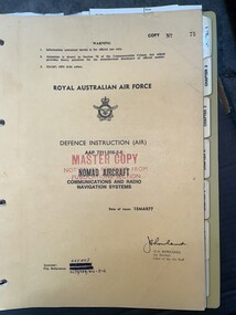
Manual (item) - (SP) AAP 7211.016-2-6 Nomad Aircraft Communications and Radio Navigation Systems
... (SP) AAP 7211.016-2-6 Nomad Aircraft Communications and Radio Navigation Systems...Moorabbin Air Museum Moorabbin Airport 12 First Street Moorabbin melbourne Manual (SP) AAP 7211.016-2-6 Nomad Aircraft Communications and Radio Navigation Systems ... -
Moorabbin Air Museum
Manual (item) - Collection of Pilot's Handbooks for Various Navigation Systems
... Collection of Pilot's Handbooks for Various Navigation Systems...One manual has a name, D Kipman, on the front page Five soft-cover booklets bound with plastic rings Manual Collection of Pilot's Handbooks for Various Navigation Systems ...Contains handbooks for: Omega CMA-740, Tracor 7640, Bendix Omega ONS-25-4, LTN-72, LTN-201 systems. One manual has a name, D Kipman, on the front page -
Moorabbin Air Museum
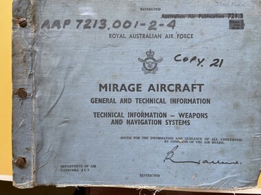
Manual (Item) - Mirage Aircraft General And Technical Information - Weapons And Navigation Systems
... Mirage Aircraft General And Technical Information - Weapons And Navigation Systems...Manual Mirage Aircraft General And Technical Information - Weapons And Navigation Systems ...Description: 350 pages. Published by RAAF. Published January 1982. AAP 7213.002-4-5, Chapter 2 Section 4-6 Level of Importance: World. -
 Moorabbin Air Museum
Manual (Item) - (SP) AAP 7213.001-2-4 RAAF Pub 721:3 Mirage aircraft general and technical information weapons and navigation systems Volume 1 Part 2 Book 1
... (SP) AAP 7213.001-2-4 RAAF Pub 721:3 Mirage aircraft general and technical information weapons and navigation systems Volume 1 Part 2 Book 1...Moorabbin Air Museum Moorabbin Airport 12 First Street Moorabbin melbourne Manual (SP) AAP 7213.001-2-4 RAAF Pub 721:3 Mirage aircraft general and technical information weapons and navigation systems Volume 1 Part 2 Book 1 ... -
Moorabbin Air Museum
Manual - RAAF flying manuals, Royal Australian Air Force Flying - Volume 3 Radio and Radar
... ...Hyperbolic navigation systems...RAAF Flying manuals Communications Communications procedures Hyperbolic navigation systems Doppler navigation systems Airborne search radar Approach & landing aids Part of 10 volume general reference on flying , circa 1960 Royal Australian Air Force Flying - Volume 3 Radio and Radar Manual RAAF flying manuals ...Part of 10 volume general reference on flying , circa 1960non-fictionPart of 10 volume general reference on flying , circa 1960communications, communications procedures, hyperbolic navigation systems, doppler navigation systems, airborne search radar, approach & landing aids -
 Wangaratta RSL Sub Branch
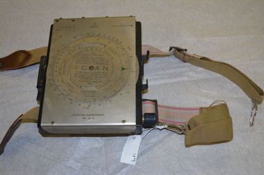
Instrument - Aircraft Navigation Computer
... RAAF Computer Navigational system MK. III. D. Serial No WG 2833...The instrument was made by White and Gillespie (Melbourne) Pty Ltd c 1940 for the RAAF and used during WW2. navigation raaf computer aircraft ww2 1940 RAAF Computer Navigational system MK. III. D. Serial No WG 2833 Black metal box with silver metal flap top cover affixed with rotating circular rule . ...The navigational computer was a circular slide rule used for calculating height and air speed corrections when flying an aircraft. The front cover lifts to reveal a further calculator used to solve vector triangles and plot course alterations. The device was intended to be strapped to a pilot's leg. The instrument was made by White and Gillespie (Melbourne) Pty Ltd c 1940 for the RAAF and used during WW2.Black metal box with silver metal flap top cover affixed with rotating circular rule . Two adjustable belts are affixed to the base of black box. A small spiral bound note book is contained beneath the flap top. RAAF Computer Navigational system MK. III. D. Serial No WG 2833navigation, raaf, computer, aircraft, ww2, 1940 -
Moorabbin Air Museum
Manual - RAAF training manuals, Royal Australian Air Force Flying - Volume 4 Aircraft Instruments & Instrument Systems
... ...Inertial navigation systems...Moorabbin Air Museum Moorabbin Airport 12 First Street Moorabbin melbourne RAAF Training Manuals Air data instruments Computing principles & circuits Inertial navigation systems Astronomical instruments Miscellaneous instruments Overview of aircraft instruments & instrument system for RAAF trainees, circa 1969 Royal Australian Air Force Flying - Volume 4 Aircraft Instruments & Instrument Systems Manual RAAF training manuals ...Overview of aircraft instruments & instrument system for RAAF trainees, circa 1969non-fictionOverview of aircraft instruments & instrument system for RAAF trainees, circa 1969air data instruments, computing principles & circuits, inertial navigation systems, astronomical instruments, miscellaneous instruments -
Moorabbin Air Museum
Book - Airbus A300 manuals, Airbus A300 Operating Manual
... system...Hydrauilics...Ice & rain...Landing gear...Navigation...Moorabbin Air Museum Moorabbin Airport 12 First Street Moorabbin melbourne Airbus A300 manuals Air conditioning & pressurization Automatic flight Auxiliary power unit Communications Electrical Emergency equipment Fire protection Flight controls Flight instruments Fuel system Hydrauilics Ice & rain Landing gear Navigation systems Pneumatics Power plant Water & waste systems Warning systems Technical overview of all systems on Airbus A300, circa 1979 - 1982ic Airbus A300 Operating Manual Book Airbus A300 manuals ...Technical overview of all systems on Airbus A300, circa 1979 - 1982icnon-fictionTechnical overview of all systems on Airbus A300, circa 1979 - 1982icair conditioning & pressurization, automatic flight, auxiliary power unit, communications, electrical, emergency equipment, fire protection, flight controls, flight instruments, fuel system, hydrauilics, ice & rain, landing gear, navigation systems, pneumatics, power plant, water & waste systems, warning systems -
Moorabbin Air Museum
Manual - TAA Trans Australia Airline Boeing 727 Training Manual, TAA Training Manual Boeing 727 Nav/AFCS Book No.1
... Navigation techniques & systems...Moorabbin Air Museum Moorabbin Airport 12 First Street Moorabbin melbourne TAA Boeing 727 Navigation techniques & systems Navigation training manual for TAA Boeing 727 airliner. circa 1982 TAA Training Manual Boeing 727 Nav/AFCS Book No.1 Manual TAA Trans Australia Airline Boeing 727 Training Manual ...Navigation training manual for TAA Boeing 727 airliner. circa 1982non-fictionNavigation training manual for TAA Boeing 727 airliner. circa 1982navigation techniques & systems -
Moorabbin Air Museum
Manual - Trans Australia Airlines training manuals, TAA Training Manual DC-9 Chapter 34 Navigation 22 Autopilot
... Navigation...Airliner systems & autopilot...Moorabbin Air Museum Moorabbin Airport 12 First Street Moorabbin melbourne TAA Training Navigation Airliner systems & autopilot Overvew of Douglas DC - 9 navigation & autopilot systems circa 1981 Spiral bound manual TAA Training Manual DC-9 Chapter 34 Navigation 22 Autopilot Manual Trans Australia Airlines training manuals ...Overvew of Douglas DC - 9 navigation & autopilot systems circa 1981Spiral bound manualnon-fictionOvervew of Douglas DC - 9 navigation & autopilot systems circa 1981navigation, airliner systems & autopilot -
Moorabbin Air Museum
Manual - Ansett Boeing 727 operating manuals, Boeing 727 Operating Manual Section 7 Part 2 Avionics Systems April 1986
... Navigation...Warning systems...Moorabbin Air Museum Moorabbin Airport 12 First Street Moorabbin melbourne Ansett Boeing 727 operating manuals Automatic flight Communications Electrical Flight instruments Navigation Warning systems Overview of Boeing 727 avionics systems circa 1986 Spiral bound book style manual Boeing 727 Operating Manual Section 7 Part 2 Avionics Systems April 1986 Manual Ansett Boeing 727 operating manuals ...Overview of Boeing 727 avionics systems circa 1986Spiral bound book style manualnon-fictionOverview of Boeing 727 avionics systems circa 1986automatic flight, communications, electrical, flight instruments, navigation, warning systems -
 Bendigo Military Museum
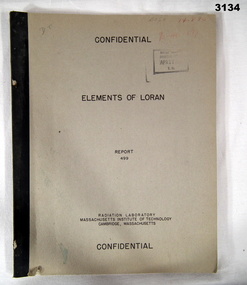
Manual - RADIO NAVIGATION, Radiator Laboratory, Massachusetts Institute of Technology, Elements of LORAN, Report 499, 1944
... LORAN is a radio navigation system....Bendigo Military Museum 37 - 39 Pall Mall Bendigo goldfields LORAN is a radio navigation system. books reference/military/manuals radio Some random numbers written on front top right. ...LORAN is a radio navigation system.Marked Confidential. Khaki coloured soft cover book with black print. Illustrated with drawings, charts, mathematics, 45 pages.Some random numbers written on front top right.books reference/military/manuals, radio -
Moorabbin Air Museum
Document (Item) - Mirage Iii O Tg12-4
... Description: MIRAGE AVIONICS WEAPONS AND NAVIGATIONAL SYSTEMS 20 PAGES Level of Importance: . ...Moorabbin Air Museum Moorabbin Airport 12 First Street Moorabbin melbourne Description: MIRAGE AVIONICS WEAPONS AND NAVIGATIONAL SYSTEMS 20 PAGES Level of Importance: . ...Description: MIRAGE AVIONICS WEAPONS AND NAVIGATIONAL SYSTEMS 20 PAGES Level of Importance: . -
Moorabbin Air Museum
Manual (Item) - (SP) Technical Manual Illustrated Parts Breakdown Electrical System Aircraft: Bandeirante T.O.Emb110 P1-4
... Description: Radio communications Navigation Systems EMB 110P1 Publisher: Embraer Level of Importance: World. ...Moorabbin Air Museum Moorabbin Airport 12 First Street Moorabbin melbourne Description: Radio communications Navigation Systems EMB 110P1 Publisher: Embraer Level of Importance: World. ...Description: Radio communications Navigation Systems EMB 110P1 Publisher: Embraer Level of Importance: World. RAAF -
Moorabbin Air Museum
Manual - Trans Australia Airlines Airbus A300, TAA Training Manual A300 Loading Fire Navigation Communications AFCS Pilots Book No..4
... systems...Navigation...Moorabbin Air Museum Moorabbin Airport 12 First Street Moorabbin melbourne TAA Airbus A300 Loading Fire systems Navigation Communications AFCS Summary and graphic overview of Airbus A300 loading, fire, navigation , communications systems & AFCS, circa 1982 Spiral bound manual TAA Training Manual A300 Loading Fire Navigation Communications AFCS Pilots Book No..4 Manual Trans Australia Airlines Airbus A300 ...Summary and graphic overview of Airbus A300 loading, fire, navigation , communications systems & AFCS, circa 1982Spiral bound manualnon-fictionSummary and graphic overview of Airbus A300 loading, fire, navigation , communications systems & AFCS, circa 1982loading, fire systems, navigation, communications, afcs -
Moorabbin Air Museum
Manual (Item) - Overhaul & Repair Manual For Wirraway
... Published May 1977. Carousel Navigation System Pilot's Guide. Level of Importance: World. ...Published May 1977. Carousel Navigation System Pilot's Guide. Level of Importance: World. ...Description: 44 pages. Published by Delco Electronics. Published May 1977. Carousel Navigation System Pilot's Guide. Level of Importance: World. -
 Moorabbin Air Museum
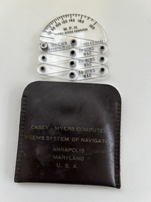
Instrument (Item) - Casey-Myers Computer Weems System Of Navigation
... Casey-Myers Computer Weems System Of Navigation....Casey-Myers Computer Weems System Of Navigation....Casey-Myers Computer Weems System Of Navigation....Moorabbin Air Museum Moorabbin Airport 12 First Street Moorabbin melbourne Casey-Myers Computer Weems System Of Navigation. Casey-Myers Computer Weems System Of Navigation. ... -
Moorabbin Air Museum
Manual (Item) - Wasp Junior R935 Engines Manual
... McDonnell Douglas F-4E Inertial Navigation Bombing System Handbook Level of Importance: World. ...McDonnell Douglas F-4E Inertial Navigation Bombing System Handbook Level of Importance: World. ...Description: 150 pages. Published by Litton Industries Inc. Published January 1969. McDonnell Douglas F-4E Inertial Navigation Bombing System Handbook Level of Importance: World. -
 Melbourne Tram Museum
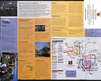
Map, Swanston Trams, "Trams put Melbourne at your fingertips.", c1999
... Provides a pocket size Map of central Melbourne, Australia, detailing Inner City Attractions, including points of interest, shopping, restaurants, and train stations, with a grid reference system for navigation. Published by Swanston Trams c1999. ...Provides a pocket size Map of central Melbourne, Australia, detailing Inner City Attractions, including points of interest, shopping, restaurants, and train stations, with a grid reference system for navigation. Published by Swanston Trams c1999. ...Provides a pocket size Map of central Melbourne, Australia, detailing Inner City Attractions, including points of interest, shopping, restaurants, and train stations, with a grid reference system for navigation. Published by Swanston Trams c1999. Has a photo of tram 2097 in The Met livery on the cover.Demonstrates a pocket sized map published by Swanston Trams.Map - pocket - 18 fold - printed in full colour with light card cover sections.tramways, melbourne, tram services, swanston trams, map, b2 class, tram 2097 -
 Bendigo Military Museum
Photograph - Royal Australian Survey Corps Aerial Surveys, c1980
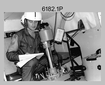
... Introduced in 1974–1975, the Magnavox AN/PRR-14 portable Doppler satellite (US Navy Navigation Satellite System – TRANSIT) receivers and computing system provided independent three-dimensional point positions anywhere in the world, anytime, in any weather accurate to about 1.5metres with precise satellite ephemerides. ...Introduced in 1974–1975, the Magnavox AN/PRR-14 portable Doppler satellite (US Navy Navigation Satellite System – TRANSIT) receivers and computing system provided independent three-dimensional point positions anywhere in the world, anytime, in any weather accurate to about 1.5metres with precise satellite ephemerides. ...This is a set of nine photographs of technicians from the Royal Australian Survey Corps operating aerial surveys equipment c1980s. In photo .1P, CPL Steve Gloster was operating a RC10 air survey camera mounted in an Australian Army Pilatus Porter aircraft. The Wild RC10 super wide-angle air survey cameras were first introduced in 1971, were equipped with virtual distortion free lenses for supplementary, spot and special photography. In photo .2P, Roger Rees was operating Air Profile Recorder (APR) equipment. it was possibly taken during OP NERVOSE 84, sometime between June – August 1984 when based in Ngukurr, Northern Territory. The APR was operated at this time in unison with an RC10 camera. In 1963 the Royal Australian Survey Corps introduced the radar airborne profile recorder (Canadian Applied Research Ltd, Mark V, Airborne Profiler Recorder) was introduced for 1:100,000 mapping to replace terrain heighting by aneroid barometry. Later in 1974-1975, the Australian developed WREMAPS II airborne laser terrain profile recorder was introduced. In photo .3P, Neil Jones appears at the door of Airsearch Beechcraft Queen Air aircraft, Registration / Serial VH-MWX. This aircraft was typically used by RA Svy on air survey operations flying mission with Aerodist, APR and RC10 camera equipment. The Australian Army’s Pilatus Porter (short take-off and landing turbo propeller) was also equipped with a Wild RC10 aerial mapping camera for identification photography. The Pilatus Porter was also used on RA Svy’s map field checking operations. Photo .9P was taken at a survey station at an unknown location. In this photo an Australian Army Kiowa Light Observation Helicopter (LOH) is supporting a field survey party undertaking Magnavox AN/PRR-14 portable Doppler satellite observations. The satellite receiver’s antenna is plumbed over the survey ground mark surrounded by white plastic panels. The panels were used to identify the survey station on aerial photography. Introduced in 1974–1975, the Magnavox AN/PRR-14 portable Doppler satellite (US Navy Navigation Satellite System – TRANSIT) receivers and computing system provided independent three-dimensional point positions anywhere in the world, anytime, in any weather accurate to about 1.5metres with precise satellite ephemerides. The Bell OH-58 Kiowa LOH was a family of military helicopters used for observation, utility, and direct fire support. It was identified by RA Svy in the mid-1970s that considerable time was lost in replacing unserviceable remote equipment by road. Therefore Aerodist operations (pre-dating satellite receiver operations) were fully supported by Army’s Kiowa LOH aircraft. This is a set of nine photographs of technicians from the Royal Australian Survey Corps operating aerial surveys equipment c1980s. .1P to .3P, .5P to .9P - Colour and black and white photos on photographic paper and scanned at 300 dpi. .4P - Colour photo on 35mm slide film and scanned at 96 dpi. .1) & .2) - Photo, black & white, c1980s, CPL Steve Gloster operating an RC10 air camera. .3) - Photo, colour, 1984, Roger Rees operating Air Profile Recorder (APR) equipment. .4) - Photo, colour, c1980s, Neil Jones at the door of an Airsearch Beechcraft Queen Air aircraft, typically used by RA Svy on air survey operations. .5) - Photo, colour, c1980s. A Beechcraft King Air aircraft, also used by RA Svy on air survey operations. .6) - Photo, colour, c1980s. An Australian Army Pilatus Porter, used by RA Svy on air survey and map field checking operations. SGT Peter Mustart is possibly in the foreground. .7) to .8) - Photo, colour, c1980s. An Australian Army Pilatus Porter and unidentified personnel, used by RA Svy on air survey and map field checking operations. .9) - Photo, colour, c1980s. An Australian Army Kiowa helicopter supporting a field survey party undertaking Magnavox AN/PRR-14 portable Doppler satellite observations. There are biro marks on photos .4P to .9Proyal australian survey corps, rasvy, army survey regiment, asr, fortuna, aerial surveys -
 Nhill Aviation Heritage Centre
Black and white photograph, Local photograph. Original of this scan held by Nhill Historical Society, Aeradio Building c1937
... The building and its equipment were part of a comprehensive system of radio towers, signalling and meteorology equipment aimed at providing safer navigation for aircraft travelling throughout Australia. ...The building and its equipment were part of a comprehensive system of radio towers lights and signalling equipment aimed at providing safer navigation for aircraft travelling throughout Australia. ...The building and its equipment were part of a comprehensive system of radio towers lights and signalling equipment aimed at providing safer navigation for aircraft travelling throughout Australia. ...This building is still intact at the Nhill Aerodrome. Some of the infrastructure is also in place or can be evidenced by its foundations.The Aeradio building was built on the present aerodrome in 1937. This was one of only sixteen buildings of this type built across Australia and it housed radio communications and guidance equipment. The building and its equipment were part of a comprehensive system of radio towers, signalling and meteorology equipment aimed at providing safer navigation for aircraft travelling throughout Australia. The facility closed in the 1960sThis photo is significant due to it having been taken soon after the building was constructed. It is the earliest known photograph taken on an open to the public day before the receiver aerials were erected.The Aeradio building was built on the present (2012) aerodrome in 1937 or 1938. This was one of only fifteen buildings of this type built across Australia and it housed radio communications and guidance equipment. The building and its equipment were part of a comprehensive system of radio towers lights and signalling equipment aimed at providing safer navigation for aircraft travelling throughout Australia. The facility closed in the 1960sphoto, aeradio, early, civil aviation, dca, dept of civil aviation -
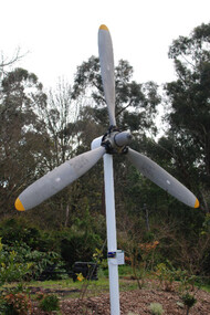 Running Rabbits Military Museum operated by the Upwey Belgrave RSL Sub Branch
Propeller for a DHC-4 Caribou light transport
... It was the last piston-engined aircraft in the Air Force and was our only aircraft to employ the Low Altitude Parachute Extraction System (LAPES), where up to 2000kg of sled-mounted cargo is extracted from the aircraft by a parachute from a metre above the ground. The Caribou is equipped with GPS satellite navigation ...DHC-4 Caribou light transport The Royal Australian Air Force DHC-4 Caribou was a versatile tactical light transport aircraft . Its main operational role was tactical air transport in support of the Australian Army. The Caribou was last operated by No 38 Squadron from RAAF Base Townsville in December 2009. The Caribou is a twin-engined high-wing monoplane with full-span double-slotted Fowler flaps and fully-reversible propellers, which allow it to achieve its trademark steep approach with very short take-offs and landings on unprepared runways. The high wing and distinctive high placement of the tail provide easy access to a large cargo compartment, while the low-pressure tyres permit operation on unprepared runways. It was the last piston-engined aircraft in the Air Force and was our only aircraft to employ the Low Altitude Parachute Extraction System (LAPES), where up to 2000kg of sled-mounted cargo is extracted from the aircraft by a parachute from a metre above the ground. The Caribou is equipped with GPS satellite navigation and night-vision equipment, giving it the capability to operate in any weather, day or night, to either land or drop soldiers and equipment by parachute with pinpoint accuracy. The Caribou is not pressurised and is not fitted with auto-pilot or weather radar. The first Caribou arrived in Australia in April 1964 and they were deployed to Vietnam from July 1964 to February 1972 and carried over 600,000 passengers and a huge quantity of cargo while they were there. Since 1997 the Caribou participated in famine-relief operations in Papua New Guinea and Irian Jaya during Operations SIERRA, PLES DRAI and AUSINDO JAYA, as well as the tsunami-relief operation in PNG in 1999 and operations in East Timor and the Solomon Islands since 1999. Their service life was over 40 years. raaf caribou aircraft