Showing 11 items matching "navigational calculations"
-
 Flagstaff Hill Maritime Museum and Village
Book - Mariner's Pocket Book, Captain John Budge Murray, circa 1881 - 1887
... ...navigational calculations...It is 119 pages long and contains a mix of detailed navigational calculations and lessons, diary entries, drill commands for soldiers "On Parade" and personal jottings. ...It is 119 pages long and contains a mix of detailed navigational calculations and lessons, diary entries, drill commands for soldiers "On Parade" and personal jottings. ...This is a small pocketbook owned by Master Mariner John Budge Murray. It is 119 pages long and contains a mix of detailed navigational calculations and lessons, diary entries, drill commands for soldiers "On Parade" and personal jottings. The dates in the notebook span the years from 1881 to 1887 and mention trips from Hong Kong to Singapore, Galle, Colombo, the Suez Canal, Aden, Port Said, Malta, Gibraltar and London. Two of the ships mentioned include the S. S. Bangalore and the S. S. Assam - both belonged to the "Peninsula and Oriental Steam Navigation Company" (later known as the P&O Line). John Budge Murray was born in 1847 at Olrig, Caithness in Scotland. During the course of his career, he was a merchant marine employed by the Peninsula and Oriental Steam Navigation Company (better known as P&O) and also became a master mariner and Captain serving in the Chinese Naval Service. When he married in 1888, his marriage certificate listed his occupation as "Captain in the Chinese Naval Service". Family records show his sister describing him as "commanding three frigates in the South China Sea - allegedly chasing pirates!" His obituary in the "John O'Groat Journal" in 1910 said he was "one of the original contingent of Britons who served as officers in the Chinese Fleet ...it was they who cleared the Chinese seas of the pirates who infected them." It went on to say "Captain Murray was brave even to the most reckless exposure of his life and ... the Chinese crews had explicit faith in him." John Murray and his wife Jessie had four children and by 1901 were living on a farm at Aucorn in Caithness. One of his sons (also called John Budge Murray) immigrated to Australia and joined the 8th Battalion, AIF (Australia Imperial Force) in 1915 and was killed in France in August 1918. Captain Murray died at Olrig in 1910. In 1840 the Peninsula Steam Navigation Company won a contract for the mail service between the U.K. and Egypt. They expanded their operations to include mail contracts to Alexandria, from Suez to Ceylon, Madras and Calcutta and in 1845 further expanded their operations to Shanghai. Steam communication with Australia was inaugurated in 1852 and in 1854 the Bombay Mail Service passed from the East India Company to P&O. By 1884 P&O's fleet contained fifty ships including the S.S. Assam and S.S. Bangalore - both are mentioned in Captain Murray's pocketbook. In 1882 the S.S. Bangalore was operating in the Bombay / Far East mail service and had made several trips in 1876 between Bombay and Melbourne. In 1875, the Qing Dynasty began to establish a modern Imperial Navy. They ordered a series of warships from Britain and Germany. Two of these ships (the Chaoyong and the Yangwoi) were built at the Tyne shipyards and sailed to China in 1881. They also needed to improve the skills of their naval personnel, and some skilled officers were recruited from Britain. This pocketbook is a significant example of a Master Mariner's everyday working pocketbook. It is also an important object as it belonged to a Scottish Master Mariner who held the unusual position as an officer in the Chinese Naval Fleet.A Master Mariner's small pocket-sized notebook. It has a black cover, 119 pages and contains a mix of navigational records, personal addresses, diary type entries and personal jottings in ink and pencil.First page - "John Budge Murray/Aucorn /Bower/ J. B. Murray/John B/ John B Murray/ Aucorn"flagstaff hill maritime museum and village, great ocean road, captain john budge murray, captain murray, master mariner, navigational calculations, ships log, pocketbook, peninsula and oriental steam navigation company, p&o, s.s. bangalore, s.s. assam, drill commands, chinese naval service, qing dynasty, south china sea -
 Flagstaff Hill Maritime Museum and Village
Book
... Joachim Popp Hamburg Trigonometric navigational calculations at an advance level. In German....Flagstaff Hill Maritime Museum and Village 89 Merri Street Warrnambool great-ocean-road Joachim Popp Hamburg Trigonometric navigational calculations at an advance level. In German. flagstaff hill warrnambool shipwrecked-coast flagstaff-hill flagstaff-hill-maritime-museum maritime-museum shipwreck-coast flagstaff-hill-maritime-village navigation navigation school book book Navigation School Book Book ...Joachim Popp Hamburg Trigonometric navigational calculations at an advance level. In German.Navigation School Bookflagstaff hill, warrnambool, shipwrecked-coast, flagstaff-hill, flagstaff-hill-maritime-museum, maritime-museum, shipwreck-coast, flagstaff-hill-maritime-village, navigation, navigation school book, book -
 Queenscliffe Maritime Museum
Instrument - Barometer and Clock mounted on a timber cabinet and 10 associated items from the TSS Nairana, 1915
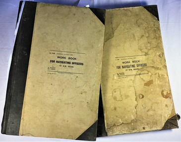
... Spence containing the navigation calculations for the journey from Plymouth to Melbourne. .05 Huddart Parker hat badge [Capt. ...Spence containing the navigation calculations for the journey from Plymouth to Melbourne. .05 Huddart Parker hat badge [Capt. ...Bass Strait passenger ship Nairana. Built for Bass Strait ferry operator Huddart Parker & Co. Ltd. of Melbourne during World War One, the Nairana was requisitioned by the Royal Navy and completed as a seaplane carrier, HMS Nairana. Serving from 1917 to 1920 participating in the capture of Archangel during the Bolshevik Revolution. After 1920 she was decommissioned as a seaplane carrier and returned to her Australian owners crossing Bass Strait until she was laid up in 1948. Just off Port Phillip Heads on April 12 1936, a strong wave struck the Nairana, tipping her over for two minutes before she righted herself again. During the horrifying two minutes, four people were drowned, and eight people were injured. The ship was reportedly carrying roughly one tonne of concrete in the hull when she tipped. Reports from the local papers said that it was a tidal wave meanwhile others were saying it was either an earthquake or a total lie. A later paper said that the ship had been caught in a rip at the mouth of the bay, causing the tragedy. The S.S Nairana, was sold for £4,000 (over $170,200 in today’s money!) in 1951 after two years of being stranded on the beach at Port Melbourne, when the moorings broke one night during a storm and drifted ashore, causing her to wreck.Items associated with the TSS/HMS Nairana in its military and civilian roles and items relating to Capt. JF Spence, navigation Officer and possibly later the captain who sailed with the Nairana out of Plymouth after WWI. .01 Barometer and Clock from Dining Saloon .02 Commemorative plaque describing the HMS Nairana's WWI service with timber mount for plaque with information sheet attached. .03 Clock Key .04 Two 2 Log books owned by Capt. Spence containing the navigation calculations for the journey from Plymouth to Melbourne. .05 Huddart Parker hat badge [Capt. JF Spence].Barometer and Clock from dining saloon, TSS Nairana 1917 - 1951 Clock Key - 4 50-No9 Hat badge - HPtss nairana, wwi, bass strait, huddart parker, capt. spence -
 Bendigo Military Museum
Map - EASTER NEW GUINEA NAVIGATION CHART, RAAF, Aug 1943
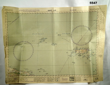
... The map on side 1 has numerous navigation tracks and calculations in pencil. i.e. LAE, KOKODA, PORT MORESBY....WW2 RAAF New Guinea The map on side 1 has numerous navigation tracks and calculations in pencil. i.e. LAE, KOKODA, PORT MORESBY. ...From the collection of "Maxwell Lennox Matheson" No.418447 RAAF. Enlisted 22/5/1942 Aged 19. Discharged 19/2/1948 - Rank FLTLT.This map is in colour. It is made of a stiff paper and has a map printed on both sides. Side1 - scale 1:2,315,000. 31.72 Nautical miles = 1 inch. It shows Eastern half of New Guinea. It also shows New Britain and New Ireland. Manus Island is at the top. Side 2 - Scale 1:1,000,000 - this shows Manus Island on right side, top of New Guinea at bottom edge (Wewak) and some other little islands. The map on side 1 has numerous navigation tracks and calculations in pencil. i.e. LAE, KOKODA, PORT MORESBY.ww2, raaf, new guinea -
 Flagstaff Hill Maritime Museum and Village
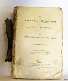
Book - Technical Reference, Henry Raper, Lieut. R.N, The Practice of Navigation and Nautical Astronomy, 1891
... It includes topics on nautical navigation, astronomy, navigation charts, calculations and mathematical tables, time, tides, ships, longitude, and position at sea. ...It includes topics on nautical navigation, astronomy, navigation charts, calculations and mathematical tables, time, tides, ships, longitude, and position at sea. ...This technical textbook is the nineteenth edition of the book by Henry Raper, Lieutenant in the Royal Navy with awards that include F.R.A.S. (Fellow of the Royal Astronomical Society) and F.R.G.S. (Friend of the Royal Geographical Society). The book is dedicated in honour of Rear-Admiral Sir Francis Beaufort K.C.B., Hydrographer to the Admiralty. He was awarded the title K.C.B. (King's Commander) as a Member of the Order of Bath, an order of British Chivalry, The book was first published in 1840 and soon became a resource for navigation students. It includes topics on nautical navigation, astronomy, navigation charts, calculations and mathematical tables, time, tides, ships, longitude, and position at sea. Thomas A. Hull, who revised and expanded this edition, was a Commander in the Royal Navy and had previously been Superintendent of Admiralty Charts used for navigation worldwide by seamen from many walks of life. The publisher, J D Potter of London, was at that time the sole agent for the Admiralty Charts produced by the Royal Navy. Printer Spottswoode and Co.,. was established by William Strachan in 1738. In 1819 his nephews A and R Spottswoode took over the business and bought premises in New-Street Square and Shoe Lane. In 1850 over 200 workers were employed by the firm. and five years later the business became Spottswoode & Co. Andrew Spottswoode invented the Spottswoode Press.This technical book was very popular as a textbook for students of maritime navigation, written and updated by members of the British Royal Navy and relied upon for accurate advice and information. The first edition was published in 1840, this edition was updated, expanded and published in 1891 when ports around the world were filling with travellers, merchants and business people. Title: The Practice of Navigation and Nautical Astronomy Author: Henry Raper, Lieut, R.N., F.R.A.S., F.R.G.S. Nineteenth Edition, revised and enlarged by Commander Thomas A. Hull, R.N., Late Superintendant of Admiralty Charts Dedication: To Rear-Admiral Sir Francis Beaufort K.C.B. Publisher: J D Potter, London, sole agent for the sale of Admiralty Charts Printer: Spottswoode and Co. New-Street Square, London Date: 1891 Small leather hardcover book with gold embossed text and lines on the spine. The Dedication in the book is as follows: - "To Rear-Admiral Sir Francis Beaufort K.C.B. Hydrographer to the Admiralty. Sir, The eminent station which you occupy in the naval scientific world renders it highly gratifying to me to dedicate the following Work to you as a testimony of my regard and esteem; while the general accordance of my views on the subject with those of your more experienced judgement, gives me the greater confidence in laying my labours before the Public. I have the honour to be, Sir, Your obedient servant, HENRY RAPER"flagstaff hill maritime museum, maritime museum, shipwreck coast, flagstaff hill, warrnambool, flagstaff hill maritime village, book, navigation, nautical astronomy, hydrography, nautical charts, nautical navigation, astronomical navigation, admiralty charts, henry raper, thomas a. hull, royal navy, j d potter, royal astronomical society, royal geographical society, calculations, mathematical tables, longitude, latitude, nautical time, location at sea, position at sea, maritime, practical navigation, spottswoode and co., sir francis beaufort, k.c.b., rear-admiral sir francis beaufort, hydrographer to the admiralty, scientific book, naval science -
 Nhill Aviation Heritage Centre
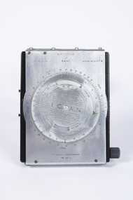
Navigation Computer
... calculations of Air Speed and Wind Drift. Indent No. G6B/145 RAAF Serial No. WG/2967* I.C.A.N. in center of front dial COMPUTER NAVIGATIONAL Ml. ...This type of instrument typically used by pilots and navigators for quick calculations of Air Speed and Wind Drift.hand operated navigation computer. Rotating scale on the front panel and a scroll type scale on the inner panel with a winder knob on the right side. Front panel is hinged at the top and bottom has two curved thigh pads.Indent No. G6B/145 RAAF Serial No. WG/2967* I.C.A.N. in center of front dial COMPUTER NAVIGATIONAL Ml. III D. -
 Flagstaff Hill Maritime Museum and Village
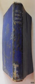
Book - Technical Reference, James Tait, Extra Master and Author et al, Tait's Home Trade Guide to the Board of Trade Examinations for Mates and Masters, 1943
... Includes tables and maps, diagrams and formulas, and navigational information. The inside covers of this book contain handwritten calculations, diagrams and notes that refer to navigation. ...Includes tables and maps, diagrams and formulas, and navigational information. The inside covers of this book contain handwritten calculations, diagrams and notes that refer to navigation. ...The book includes navigational information, tables and maps, diagrams and formulas. It was written for Examiners and Students studying for their nautical Mates and Masters marine qualifications— notes have been handwritten inside the front and back covers. Notes in point form: 1. I have seen the back of a torpedo EBoat or UBoat in my starboard side 2. I _ _ _ to - - - - - - - - - Port side 3. at a distance ----------- 4. Enemy surface vessel in sight __________ 5. suspicious vessel in sight 6. enemy (undecipherable) 7. I have cut a _ _ _ adrift with my _ _ 8. FI_ _ WISE _ _ _ 9. STARWISE 0. OPEN FIREThis relatively rare book provided up-to-date navigational information during World War II. It was to be used by Examiners to assess whether students qualified to be a Ship's Mate or Ship's Master. The contents of the book were based on maritime knowledge gained over centuries. It is an aid to understanding the navigational methods of the time and the changes and improvements in more recent history.Title: Tait's Home Trade Guide: to the Board of Trade Examinations for Mates and Masters Author: James Tait, Extra Master Publisher: Brown, Son and Ferguson, Ltd. Glasgow, Great Britain Date: Revised Edition 1943 Further Information: Fourteenth Edition 1941, Reprinted Edition 1943. Revised and brought up to date by Captain H. T. Jefferys, Extra Master Printed by Nautical Press, Brown, Son & Ferguson, Limited, 52-58 Darnley Street, Glasgow Hardcover, small book, royal blue cover, silver embossed text on spine. Textbook for Mariners. Includes tables and maps, diagrams and formulas, and navigational information. The inside covers of this book contain handwritten calculations, diagrams and notes that refer to navigation. Notes inside the back cover refer to an enemy vessel and OPEN FIRE.Spint, in silver embossing "TAIT'S HOME TRADE GUIDE" Handwritten inside the back cover "R.A.D. / MOORE / PT. WELCH" Included with the text inside the back cover "Gascoyne" "506" and "RCM"flagstaff hill, warrnambool, shipwrecked coast, flagstaff hill maritime museum, maritime museum, shipwreck coast, flagstaff hill maritime village, great ocean road, james tait, brown, son and ferguson limited, torpedo, open fire, pt welch, vessel gascoyne, e-boat, u-boat, marine technology, world war ii, wwii, ww2, navigation exams, ship's mate, ship's master, wwii textbook, nautical textbook, navigational textbook, examination textbook, world war ii textbook, 1943 nautical textbook -
 City of Moorabbin Historical Society (Operating the Box Cottage Museum)
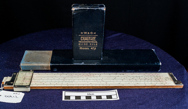
Tools, Trigonomertrical sliding scale rule in box, c1940
... It released many significant recordings by Australian popular artists of the 1960s and also issued recordings of popular American artists, notably releases from ABC-Paramount (Ampar) label, which W&G distributed from 1955 until 1960, when the Australian distribution was taken over by Festival Records. measurements slide rulers physics calculations ship design navigation ww11 1939-45 white & gillespie record processing company melbourne bentleigh moorabbin cheltenham australian defense force W & G / DUALFACE / TRIGONOMETRICAL / SLIDE RULE / MODEL 476 A Trigonometrical sliding scale rule in its original box Tools, Trigonomertrical sliding scale rule in box White & Gillespie Record Processing Company ...W&G 476 "Dual-Face" Trigonometrical (Stadia) Made in Melbourne, Australia by White & Gillespie Record Processing Co. a precision engineering firm. Front Scale LL (or LL3), L, A [ B, Reciprocal (or CI), C ] D, Cu, LL (or LL2) Back Scale Stadia V, H, Chord, A [ B, SIN<6 COS>5, SIN>5 COS <6, C ] D, TAN 30-6, COT 84-90, TAN 5-45, COT 85-45 Conventional Cursor This type of sliding scale was used to design Battleships during WWII. A subsidiary was W&G Records an Australian recording company that operated from the early 1950s to the 1970s. It released many significant recordings by Australian popular artists of the 1960s and also issued recordings of popular American artists, notably releases from ABC-Paramount (Ampar) label, which W&G distributed from 1955 until 1960, when the Australian distribution was taken over by Festival Records. A Trigonometrical sliding scale rule in its original boxW & G / DUALFACE / TRIGONOMETRICAL / SLIDE RULE / MODEL 476 measurements, slide rulers, physics, calculations, ship design, navigation, ww11 1939-45, white & gillespie record, processing company, melbourne, bentleigh, moorabbin, cheltenham, australian defense force -
 Flagstaff Hill Maritime Museum and Village
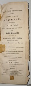
Book - Reference, navigation, J. W. Norie (author and editor), The Seaman and Merchants Complete Expeditious Measurer, 1853
... The book is important to the history of the schooner Rose Anna, which is listed as a significant vessel on the Victorian Heritage Register, S582, as it has an inscription with the ship's name, date, and destination. flagstaff hill warrnambool shipwrecked-coast flagstaff-hill flagstaff-hill-maritime-museum maritime-museum shipwreck-coast flagstaff-hill-maritime-village The Seaman and Merchants Complete Expeditious Measurer book sea merchants cargo calculations measurements sea trade maritime book sea transportation cargo rate calculations naval academy navy education navigation navigation instruction Navigation Waterhouse and Naval Academy twenty-fifth edition 19th century 1853 1857 Customs freight ullage Rose Anna schooner 2-masted March 25th 1857 Melbourne 25 March 1857 Thomas Lamb & E. ...The book was published at the same address as London’s Navigation Waterhouse and Naval Academy. It is likely to be one of the textbooks used in educating seafarers, both naval and merchant. It is the twenty-fifth edition, showing that it was in great demand in the early to mid-19th century. Sea merchants could have used this as a reference for working out freight costs for their cargo. Customs Officers could have referred to it as well to calculate fees and taxes. The book’s owner had inscribed in pen and ink "Rose Anna, Schooner, Melbourne, March 25th 1857". At that time, the registered owners were Thomas Lamb & E. Keays, who were freighting cargo between Melbourne and Geelong. Schooner, ROSE ANNA: - The schooner Rose Anna was built in 1844 at Fremantle, W.A., by H. Edwards for Capt. William Heard. The 2-masted wooden vessel was carvel-built. Captain Heard registered Rose Anna at Fremantle in 1845 and in the same year, registered it at Port Adelaide. in 1852, Rose Anna was crushed and sunk at Port Adelaide by the Selma and raised. In 1852, the schooner was lengthened by William Hardy. In 1853, William Burton and W. Roberts registered Rose Anna at Melbourne. In 1855, W. Roberts registered, followed by John Balston & Thomas Ross. In 1856, it was registered by Thomas Lamb & E. Keays, in 1857 by William Howes & Charles Holland, in 1865 by Charles Holland & John Balfour, and in 1866 registered in Melbourne by mariners John Balfour & David Griffiths. In the 1940s, Rose Anna traded between Hobart, Melbourne, Adelaide, Sydney, Circular Head, Port Fairy, and Port Albert. In the 1950s and 1960s, it traded between Geelong Heads and Hobsons Bay, Melbourne, in lime, wool, general cargo and ballast. In 1857, when Rose Anna’s registered owners were Thomas Lamb & E. Keays, an advertisement was placed in The Age on March 9th, announcing that the Rose Anna was taking freight from Melbourne to Geelong. Later in the year, in October, the registered owners were William Howes & Charles Holland. They were still trading with Geelong, as on October 7th, The Age announced that Rose Anna arrived in Geelong from Melbourne on October 5th. On October 6th, 1866, Rose Anna went ashore while loading wheat at Sandridge, Port Phillip Bay, in severe gales and heavy seas and became a total wreck. The book is significant for its association with reference information to instruct sea merchant traders and naval officers. The publication is in its twenty-fifth edition, indicating the importance of such an instructional book. The book of tables and calculations shows the evolution of such reference texts, going from handwritten notes, to printed tables like these, and forward to slide rules, calculators, and to modern time computers. it demonstrates the importance of accuracy in calculating weights and measures at sea and for the purposes of fess, charges and taxes. The book is important to the history of the schooner Rose Anna, which is listed as a significant vessel on the Victorian Heritage Register, S582, as it has an inscription with the ship's name, date, and destination. Book, tall and narrow, with index tabs on the side edges of the pages. FULL Title: The Seaman and Merchants Complete Expeditious Measurer: The Seaman and Merchants Complete Expeditious Measure; containing a set of tables which show, at one view, the solid contents of all kinds of packags and casks, according to their several lengths, breadths and depths: also, rules for determining the contents of all sorts of casks in wine and beer measure, according to the Imperial Standard. Twenty-Fifth (Stereotype) Edition. Author: Mr J W Norie (John William Norie) Date: 1853 Publisher: Charles Wilson (late J.W. Norrie & Wilson), Bookseller, Publisher and Stationer, At the Navigation Waterhouse and Naval Academy, No. 157, Leadenhall Street, where may be had all the publications of Steel & Co. Late at No. 70, Cornhill. Printer: Bateman and Dennis, 95 Leadenhall Street, London, England, 1853 The book has handwritten, pen and ink inscriptions. It refers to the Schooner, Rose Anna, Melbourne, March 25th 1857.Handwritten in script with pen and ink: "Rose Anna / Schooner / Melbourne, / March 25th 1857"flagstaff hill, warrnambool, shipwrecked-coast, flagstaff-hill, flagstaff-hill-maritime-museum, maritime-museum, shipwreck-coast, flagstaff-hill-maritime-village, the seaman and merchants complete expeditious measurer, book, sea merchants, cargo, calculations, measurements, sea trade, maritime book, sea transportation, cargo rate calculations, naval academy, navy education, navigation, navigation instruction, navigation waterhouse and naval academy, twenty-fifth edition, 19th century, 1853, 1857, customs, freight, ullage, rose anna, schooner, 2-masted, march 25th 1857, melbourne, 25 march 1857, thomas lamb & e. keays, geelong, 1844, h. edwards, fremantle, carvel-built, port adelaide, selma, william hardy, william burton and w. roberts, john balston & thomas ross., charles holland & john balfour, john balfour & david griffiths, hobart, sydney, circular head, port fairy, port albert, hobsons bay, sandridge, port phillip bay -
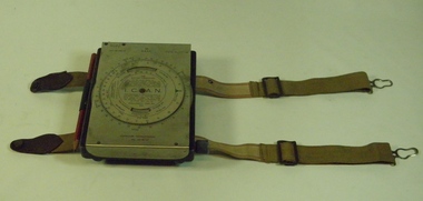 B-24 Liberator Memorial Restoration Australia Inc
Computer Navigational MkIII D, White & Gillespie (Melb) Pty Ltd, c. 1940
... B-24 Liberator Memorial Restoration Australia Inc Corner Farm Rd & Princes Highway Werribee melbourne RAAF Manual navigation aircraft calculator(early computer) General issue to allied pilots and navigators for airspeed,altitude,air temperature and drift calculations. ...RAAF Manual navigation aircraft calculator(early computer)General issue to allied pilots and navigators for airspeed,altitude,air temperature and drift calculations.Black metal box with SS flap-top cover, moulding and straps for knee attachment.Engraving No. 19, Ident.No. G6B/145. I.C.A.N. Serial No. WG/1716*. Computer Navigational Mk.IIID -
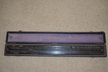 Wangaratta RSL Sub Branch
Instrument - Pilot Balloon Slide Rule
... The use of slide rules was abandoned with the wide spread adoption of computers and programs to do the calculations, as well as the decline in the use of optical pilot balloon theodolites.Made in Australia by White & Gillespie (Melb) Pty Ltd. Established in 1910, the firm was involved mainly in printing plate manufacture, but during the Second World War it manufactured a variety of navigational aids and range finding devices for the military. ...The Mark II Pilot Balloon Slide Rule was made of wood laminated with heavy white plastic with a length of 24.5-in. and width of 2.5 inches. Mark II rules were manufactured in Australia by W & G (Melbourne). The W & G rule differs only slightly from the English A. G. Thornton LTD rule. The W & G rule uses serif fonts and has some fiducial marks that the English rule lacks. Exact dates of production are not known but the MK II is known to have started production by 1927. The printed scales are engraved in the plastic faces. The slide rule has 4 captive cursors (glass windows and brass guides) that ride in slots on the top and bottom edges. Each can be moved independently of one another. The cursors are missing from this item. Brass knobs at both ends of the slide facilitate its movement. The case is fabric covered wood with felt lining. No known history for this item as located in a property after purchase. The Pilot Balloon slide rule is used to convert the observed azimuth and elevation readings into wind velocity and direction records. The use of slide rules was abandoned with the wide spread adoption of computers and programs to do the calculations, as well as the decline in the use of optical pilot balloon theodolites.Made in Australia by White & Gillespie (Melb) Pty Ltd. Established in 1910, the firm was involved mainly in printing plate manufacture, but during the Second World War it manufactured a variety of navigational aids and range finding devices for the military. About 250,000 instruments were made during that period. After the war the company produced, among other items, drawing instruments and slide rules. The long narrow case is fabric covered wood with felt fabric lining containing a long black laminate ruler with numerous white markings and numbers. Top of the ruler is in three sections with the centre section movable by small gold metal knobs at either end. This slide rule contains a engraved notation on the rear face "IMPORTANT. NORMALLY NUMBER OF GRATICULE SCALE DIVISIONS PER RADIAN (K) X LENGTH OF TAIL IN FEET (I) = 12X 105. IN OTHER CASES MULTIPLY GRATICULE READINGS BY 1.2/KI BEFORE CALCULATION ON RULE" Top of Slide Rule - RAAF Ident No G268/480 Serial WG/22pilot balloon slide rule, raaf