Showing 2 items matching "nentingbool"
-
 Federation University Historical Collection
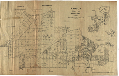
Plan, Haddon, County of Grenville, 1932, 13/04/1932
... ...nentingbool...haddon grenville cardigan water supply reserve nentingbook pre-emptive right a. mclachlan lake burrumbeet e.a. wynne p. russell b. hepburn benjamin hepburn nentingbool t.c. wilson j. amoy william collard smith james roach j. mitchell The Haddon Parish Plan shows crown parcels government roads, Crown Reserves, Railway. ...The Haddon Parish Plan shows crown parcels government roads, Crown Reserves, Railway. Scale 40 chains to 1" (1:31, 680) WGS 84 Centroid Lat: 37 degrees 34' 00" S Long: 148 degrees 40' 20" E N.S. 9.3km E.W.: 16.1kmhaddon, grenville, cardigan, water supply reserve, nentingbook pre-emptive right, a. mclachlan, lake burrumbeet, e.a. wynne, p. russell, b. hepburn, benjamin hepburn, nentingbool, t.c. wilson, j. amoy, william collard smith, james roach, j. mitchell -
 Federation University Historical Collection
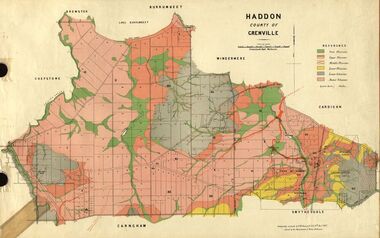
Plan, Haddon, County of Grenville, 1887, 1889
... Ferdinand Krause taught at the Ballarat School of Mines haddon grenville krause ferdinand krause cgt lake burrumbeet windermere chepstowe bailies creek snake valley lead nentingbool preemptice right cardigan state forest haddon state forest Geological Map of Haddon in the County of Grenville surveyed by Ferdinand Krause. ...Ferdinand Krause taught at the Ballarat School of MinesGeological Map of Haddon in the County of Grenville surveyed by Ferdinand Krause. haddon, grenville, krause, ferdinand krause, cgt, lake burrumbeet, windermere, chepstowe, bailies creek, snake valley lead, nentingbool preemptice right, cardigan state forest, haddon state forest