Showing 33 items matching "ninety mile beach"
-
 Lakes Entrance Historical Society
Map - Princes Highway, Lakes Entrance, Lake Tyers, Aboriginal Station, Ninety Mile Beach, Bairnsdale Victoria
... Princes Highway, Lakes Entrance, Lake Tyers, Aboriginal Station, Ninety Mile Beach, Bairnsdale Victoria...Shows Princes Highway, Lakes Entrance, Lake Tyers, Aboriginal Station, Ninety Mile Beach...Forest Waterways Townships Shows Princes Highway, Lakes Entrance, Lake Tyers, Aboriginal Station, Ninety Mile Beach Map Princes Highway, Lakes Entrance, Lake Tyers, Aboriginal Station, Ninety Mile Beach, Bairnsdale Victoria ...Shows Princes Highway, Lakes Entrance, Lake Tyers, Aboriginal Station, Ninety Mile Beachforest, waterways, townships -
Lakes Entrance Historical Society
Map - Victoria Hartland, Princes Highway, Lakes Entrance, Lake Tyers, Aboriginal Station, Ninety Mile Beach, Australian Section Imperial General Staff
... Victoria Hartland, Princes Highway, Lakes Entrance, Lake Tyers, Aboriginal Station, Ninety Mile Beach...Shows Forest, Princes Highway, Lakes Entrance, Lake Tyers, Aboriginal Station, Ninety Mile Beach...Forest Townships Roads and Streets Beaches Waterways Aboriginal Station Shows Forest, Princes Highway, Lakes Entrance, Lake Tyers, Aboriginal Station, Ninety Mile Beach Map Victoria Hartland, Princes Highway, Lakes Entrance, Lake Tyers, Aboriginal Station, Ninety Mile Beach Australian Section Imperial General Staff ...Shows Forest, Princes Highway, Lakes Entrance, Lake Tyers, Aboriginal Station, Ninety Mile Beachforest, townships, roads and streets, beaches, waterways, aboriginal station -
 Lakes Entrance Historical Society
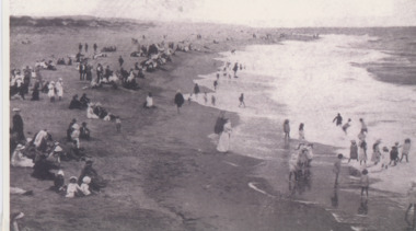
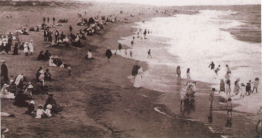
Photograph - Ninety Mile Beach Lakes Entrance Victoria 1910 c, 1910 c
... Ninety Mile Beach Lakes Entrance Victoria 1910 c...Black and white photographic print showing large crowd on Ninety Mile Beach children paddling in water Lakes Entrance Victoria c1910...Lakes Entrance Historical Society 4 Marine Parade Lakes Entrance gippsland Beaches Social History Recreation copied from Barb Garth Album Black and white photographic print showing large crowd on Ninety Mile Beach children paddling in water Lakes Entrance Victoria c1910 Photograph Ninety Mile Beach Lakes Entrance Victoria 1910 c ...Black and white photographic print showing large crowd on Ninety Mile Beach children paddling in water Lakes Entrance Victoria c1910copied from Barb Garth Albumbeaches, social history, recreation -
 Phillip Island and District Historical Society Inc.
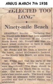
Newspaper clippings, 07/03/1938
... ...ninety mile beach...Article in which Chairman of Country Roads Board (Mr Fricke) declared that the Ninety Mile Beach had been neglected and should be a Tourist asset. ...Article about Ninety Mile Beach....The Board would arrange water supply and Comfort Station. local history documents newspapers ninety mile beach black & white newspaper clipping Article about Ninety Mile Beach. ...Article in which Chairman of Country Roads Board (Mr Fricke) declared that the Ninety Mile Beach had been neglected and should be a Tourist asset. The Board would arrange water supply and Comfort Station.Article about Ninety Mile Beach.local history, documents, newspapers, ninety mile beach, black & white newspaper clipping -
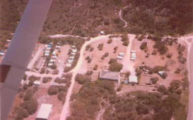
 Lakes Entrance Historical Society
Photograph, Frank Price, Ninety Mile Beach Caravan Park Lake Tyers Beach Victoria, C1983
... Ninety Mile Beach Caravan Park Lake Tyers Beach Victoria...Colour photograph of family residence of Frank and Wendy Price at Ninety Mile Beach Caravan Park, Lake Tyers Beach, Victoria...Floor plan in binder Boats and Boating Tourism Caravan Parks Colour photograph of family residence of Frank and Wendy Price at Ninety Mile Beach Caravan Park, Lake Tyers Beach, Victoria Ninety Mile Beach Caravan Park Lake Tyers Beach Victoria Photograph Frank Price ...Building moved from Esplanade Lakes Entrance 1970 c. Floor plan in binderColour photograph of family residence of Frank and Wendy Price at Ninety Mile Beach Caravan Park, Lake Tyers Beach, Victoriaboats and boating, tourism, caravan parks -
Lakes Entrance Historical Society
Administrative record - Records from Ninety Mile Beach Caravan Park 1983, 1986, 1992, 1983, 1986, 1992
... Records from Ninety Mile Beach Caravan Park 1983, 1986, 1992...VTMH10619 A, B and C Administrative record Records from Ninety Mile Beach Caravan Park 1983, 1986, 1992 ...Three record books of Advanced bookings. VTMH10619 A, B and Ccaravan parks, records -
 Lakes Entrance Historical Society
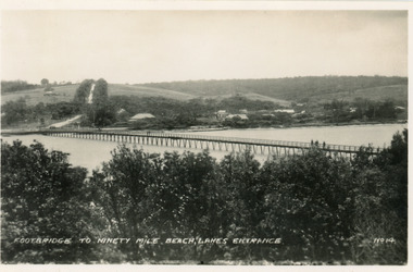
Postcard - Footbridge Lakes Entrance Victoria c1940, No14 Bulmer HD
... Footbridge to Ninety Mile Beach, Lakes Entrance...1 same image 6.5x10.5 valentine Series donated by Keith West|1 other similar image 6.5 x 10.5|1 other similar image 9 x 14|1 other similar postcard, message on back in Spares Box Bridges Waterways Township Footbridge to Ninety Mile Beach, Lakes Entrance Black and white small format postcard of the footbridge across the Cunninghame Arm, which is the access to the southern shore and ocean beach from the town. ...1 same image 6.5x10.5 valentine Series donated by Keith West|1 other similar image 6.5 x 10.5|1 other similar image 9 x 14|1 other similar postcard, message on back in Spares BoxBlack and white small format postcard of the footbridge across the Cunninghame Arm, which is the access to the southern shore and ocean beach from the town. Lakes Entrance VictoriaFootbridge to Ninety Mile Beach, Lakes Entrance bridges, waterways, township -
Lakes Entrance Historical Society
Map - Figure 2.3 Lakes Entrance Commercial Strategy-Shire of Tambo Strategy Plan, Tract Consultants Pty Ltd Landscape Architects and Urban Planners
... Shows roads and landowners, Bulloch Island, Cunninghame Arm, Ninety Mile Beach...Islands Waterways Roads Landowners Shows roads and landowners, Bulloch Island, Cunninghame Arm, Ninety Mile Beach Map Figure 2.3 Lakes Entrance Commercial Strategy-Shire of Tambo Strategy Plan Tract Consultants Pty Ltd Landscape Architects and Urban Planners ...Shows roads and landowners, Bulloch Island, Cunninghame Arm, Ninety Mile Beachislands, waterways, roads, landowners -
Lakes Entrance Historical Society
Map - Nowa Nowa Forest District - Tildesley
... Shows roads and tracks, Nowa Nowa arm of Lake Tyers, Ninety Mile beach...Lakes Entrance Historical Society 4 Marine Parade Lakes Entrance gippsland Roads and Streets Waterways Beaches Shows roads and tracks, Nowa Nowa arm of Lake Tyers, Ninety Mile beach Map Nowa Nowa Forest District - Tildesley ...Shows roads and tracks, Nowa Nowa arm of Lake Tyers, Ninety Mile beachroads and streets, waterways, beaches -
Lakes Entrance Historical Society
Map - Gippsland Lakes Hinterland Area Victoria
... Divided into Sections, Blocks and Sub-Blocks, Lake Wellington, Lake Victoria, Ninety Mile Beach...Waterways Beaches Divided into Sections, Blocks and Sub-Blocks, Lake Wellington, Lake Victoria, Ninety Mile Beach Map Gippsland Lakes Hinterland Area Victoria ...Divided into Sections, Blocks and Sub-Blocks, Lake Wellington, Lake Victoria, Ninety Mile Beachwaterways, beaches -
 Lakes Entrance Historical Society
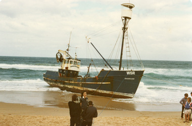
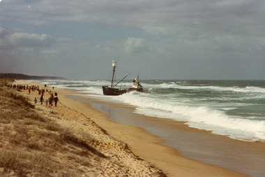
Photograph - Dageraad, 1981
... Colour photograph of the fishing vessel Dagaraad aground on the ninety mile beach beside the entrance bar...Lakes Entrance Historical Society 4 Marine Parade Lakes Entrance gippsland Vessel stranded 26 April 1981 Ships and Shipping Fishing Industry Coast Shipwrecks Colour photograph of the fishing vessel Dagaraad aground on the ninety mile beach beside the entrance bar Photograph Dageraad ...Vessel stranded 26 April 1981Colour photograph of the fishing vessel Dagaraad aground on the ninety mile beach beside the entrance barships and shipping, fishing industry, coast, shipwrecks -
 Lakes Entrance Historical Society
Photograph - Dageraad, 1981
... Colour photograph of the fishing vessel Dagaraad aground on the ninety mile beach beside the entrance bar...Lakes Entrance Historical Society 4 Marine Parade Lakes Entrance gippsland Vessel stranded 26 April 1981 Ships and Shipping Fishing Industry Coast Shipwrecks Colour photograph of the fishing vessel Dagaraad aground on the ninety mile beach beside the entrance bar Photograph Dageraad ...Vessel stranded 26 April 1981Colour photograph of the fishing vessel Dagaraad aground on the ninety mile beach beside the entrance barships and shipping, fishing industry, coast, shipwrecks -
Lakes Entrance Historical Society
Map - Boole Poole County of Tambo, A C Brooks Gov. Printer, 1965
... Map shows Lake Victoria, The Lakes National Park, Ninety Mile Beach, Land owners...Lakes Entrance Historical Society 4 Marine Parade Lakes Entrance gippsland Waterways Settlement Parks Map shows Lake Victoria, The Lakes National Park, Ninety Mile Beach, Land owners Map Boole Poole County of Tambo A C Brooks Gov. ...Map shows Lake Victoria, The Lakes National Park, Ninety Mile Beach, Land ownerswaterways, settlement, parks -
Lakes Entrance Historical Society
Map - 1991 Census Div. 4 Sheets No. 61 and 59 Lakes Entrance, 1991
... Streets, Hopetown channel, Rigby Island, Ninety Mile beach....Streets, Hopetown channel, Rigby Island, Ninety Mile beach. Map 1991 Census Div. 4 Sheets No. 61 and 59 Lakes Entrance ...Map shows Lakes Entrance with divisions marked. Streets, Hopetown channel, Rigby Island, Ninety Mile beach.roads and streets, township, waterways, islands, beaches -
Lakes Entrance Historical Society
Map - Victoria Bairnsdale, AHQ Cartographic Co, 1942
... Map show area from Stratford to Lakes Entrance, shows Princes Highway, Lake King, Ninety Mile Beach....Lakes Entrance Historical Society 4 Marine Parade Lakes Entrance gippsland Waterways Roads and Streets Townships Map show area from Stratford to Lakes Entrance, shows Princes Highway, Lake King, Ninety Mile Beach. Map Victoria Bairnsdale AHQ Cartographic Co. ...Map show area from Stratford to Lakes Entrance, shows Princes Highway, Lake King, Ninety Mile Beach.waterways, roads and streets, townships -
Lakes Entrance Historical Society
Map - Tildesley West County of Tambo, A C Brooks Govv. Printer, 1965
... Map shows Nowa Nowa Arm in Lake Tyers, Colquhoun East, land owners, Bass Strait, Ninety Mile Beach....Lakes Entrance Historical Society 4 Marine Parade Lakes Entrance gippsland Waterways land owners Settlement Map shows Nowa Nowa Arm in Lake Tyers, Colquhoun East, land owners, Bass Strait, Ninety Mile Beach. Map Tildesley West County of Tambo A C Brooks Govv. ...Map shows Nowa Nowa Arm in Lake Tyers, Colquhoun East, land owners, Bass Strait, Ninety Mile Beach.waterways, land owners, settlement -
 Lakes Entrance Historical Society
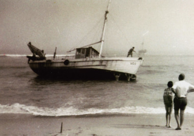
Photograph - Finn William Grounded, 1973
... Black and white photograph of scallop boat Finn William grounded off Ninety Mile beach with two people in foreground Lakes Entrance Victoria...Lakes Entrance Historical Society 4 Marine Parade Lakes Entrance gippsland Boats and Boating Waterways Disasters Black and white photograph of scallop boat Finn William grounded off Ninety Mile beach with two people in foreground Lakes Entrance Victoria Photograph Finn William Grounded ...Black and white photograph of scallop boat Finn William grounded off Ninety Mile beach with two people in foreground Lakes Entrance Victoriaboats and boating, waterways, disasters -
Lakes Entrance Historical Society
Map - Chart of Gippsland Lakes Victoria
... This map is a composite traced from various ordanance maps of the district, showing waterways of Lake Wellington, Lake Victoria and Lake King, Ninety Mile Beach....Waterways Beaches This map is a composite traced from various ordanance maps of the district, showing waterways of Lake Wellington, Lake Victoria and Lake King, Ninety Mile Beach. Map Chart of Gippsland Lakes Victoria ...This map is a composite traced from various ordanance maps of the district, showing waterways of Lake Wellington, Lake Victoria and Lake King, Ninety Mile Beach.waterways, beaches -
Lakes Entrance Historical Society
Map - Map of Tildesley East County of Tambo
... Map shows townships of Waygara, Bete Bolong South, Nowa Nowa South ,Tildesley West, Forest reserves, Wildlife reserve, Ninety Mile beach....Lakes Entrance Historical Society 4 Marine Parade Lakes Entrance gippsland Townships Forest Beaches wildlife Map shows townships of Waygara, Bete Bolong South, Nowa Nowa South ,Tildesley West, Forest reserves, Wildlife reserve, Ninety Mile beach. Map Map of Tildesley East County of Tambo ...Map shows townships of Waygara, Bete Bolong South, Nowa Nowa South ,Tildesley West, Forest reserves, Wildlife reserve, Ninety Mile beach.townships, forest, beaches, wildlife -
 Lakes Entrance Historical Society
Photograph - Red Bluff Lake Tyers 2008, Wendy Price, 1/08/2008 12:00:00 AM
... Colour photograph of west side of Red Bluff showing vegetation on the bluff rock and sand at the base situated on ninety mile beach Lake Tyers Victoria...This is the after photograph used in the 150 years Lakes Entrance 1858 to 2008 display held in October 2008 paired with image 03731 for display Waterways Topography Colour photograph of west side of Red Bluff showing vegetation on the bluff rock and sand at the base situated on ninety mile beach Lake Tyers Victoria Photograph Red Bluff Lake Tyers 2008 Wendy Price ...This is the after photograph used in the 150 years Lakes Entrance 1858 to 2008 display held in October 2008 paired with image 03731 for displayColour photograph of west side of Red Bluff showing vegetation on the bluff rock and sand at the base situated on ninety mile beach Lake Tyers Victoria waterways, topography -
Lakes Entrance Historical Society
Book, Hewitt Geoff Bader Hans Dieter, Geometria, 2007
... Report on the geomagnetic archaeological survey of areas of prograded Ninety Mile Beach shore in East Gippsland Victoria, immediately to the East and West of the artificial entrance to the Gippsland Lakes....Lakes Entrance Historical Society 4 Marine Parade Lakes Entrance gippsland Waterways Topography Ships and Shipping Report on the geomagnetic archaeological survey of areas of prograded Ninety Mile Beach shore in East Gippsland Victoria, immediately to the East and West of the artificial entrance to the Gippsland Lakes. ...Report on the geomagnetic archaeological survey of areas of prograded Ninety Mile Beach shore in East Gippsland Victoria, immediately to the East and West of the artificial entrance to the Gippsland Lakes.waterways, topography, ships and shipping -
 Lakes Entrance Historical Society
Photograph - Lake Tyers Beach Caravan Park, Jan. 1983
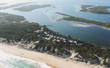
... Colour Photograph of Ninety Mile Beach caravan Park at Lake Tyers Beach Victoria. ...Lakes Entrance Historical Society 4 Marine Parade Lakes Entrance gippsland Aerial Photograph Caravan Parks Beaches Colour Photograph of Ninety Mile Beach caravan Park at Lake Tyers Beach Victoria. ...Colour Photograph of Ninety Mile Beach caravan Park at Lake Tyers Beach Victoria. Shows house rooftop, caravans and LTB Road on right hand side aerial photograph, caravan parks, beaches -
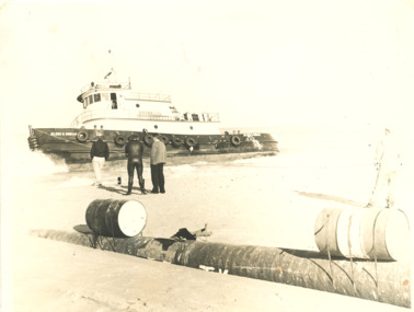 Lakes Entrance Historical Society
Photograph - Eileen B Ingram, 1980 c
... Black and white photograph of tugboat Eileen B Ingram aground on ninety mile beach, four men on shore one wearing wetsuit gas pipeline in foreground Gippsland Victoria...Lakes Entrance Historical Society 4 Marine Parade Lakes Entrance gippsland Ran aground on the 90 Mile Beach Oil and Gas Industry Bass Strait Boats and Boating Black and white photograph of tugboat Eileen B Ingram aground on ninety mile beach, four men on shore one wearing wetsuit gas pipeline in foreground Gippsland Victoria Photograph Eileen B Ingram ...Ran aground on the 90 Mile BeachBlack and white photograph of tugboat Eileen B Ingram aground on ninety mile beach, four men on shore one wearing wetsuit gas pipeline in foreground Gippsland Victoriaoil and gas industry, bass strait, boats and boating -
 Lakes Entrance Historical Society
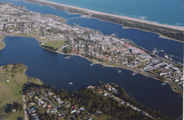
Photograph - North Arm Lakes Entrance, 2005
... Colour aerial photograph showing North Arm, township, eastern end of Cunninghame Arm across to the ocean beach, Ninety Mile beach, Bass Strait Lakes Entrance Victoria...Lakes Entrance Historical Society 4 Marine Parade Lakes Entrance gippsland Aerial Photograph Aircraft Lakes Entrance Colour aerial photograph showing North Arm, township, eastern end of Cunninghame Arm across to the ocean beach, Ninety Mile beach, Bass Strait Lakes Entrance Victoria Photograph North Arm Lakes Entrance ...Colour aerial photograph showing North Arm, township, eastern end of Cunninghame Arm across to the ocean beach, Ninety Mile beach, Bass Strait Lakes Entrance Victoriaaerial photograph, aircraft, lakes entrance -
 Lakes Entrance Historical Society
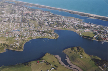
Photograph - North Arm Lakes Entrance 2005
... Colour aerial photograph showing Kalimna in foreground, North Arm, towhship, Cunninghame Arm and across to ninety mile beach and Bass Strait ocean beach Lakes Entrance Victoria...Also two colour photographs of North Arm area taken from Leigh and Judy Davies Blair Road Lakes Entrance number 03859.1 and 03859.2 sizes 10 x 15 cm and 15 x 10 cm Aerial Photograph Settlement Colour aerial photograph showing Kalimna in foreground, North Arm, towhship, Cunninghame Arm and across to ninety mile beach and Bass Strait ocean beach Lakes Entrance Victoria Photograph North Arm Lakes Entrance 2005 ...Also two colour photographs of North Arm area taken from Leigh and Judy Davies Blair Road Lakes Entrance number 03859.1 and 03859.2 sizes 10 x 15 cm and 15 x 10 cmColour aerial photograph showing Kalimna in foreground, North Arm, towhship, Cunninghame Arm and across to ninety mile beach and Bass Strait ocean beach Lakes Entrance Victoriaaerial photograph, settlement -
 Lakes Entrance Historical Society
Photograph - Gippsland Lakes, 2005 c
... Colour aerial photograph of Ocean Grange on the Gippsland Lakes ocean beach ninety mile beach in foreground Cresent Island channel through to Lake King Raymond Island in distance Paynsville Victoria...Lakes Entrance Historical Society 4 Marine Parade Lakes Entrance gippsland Aerial Photograph Settlement Gippsland Lakes Colour aerial photograph of Ocean Grange on the Gippsland Lakes ocean beach ninety mile beach in foreground Cresent Island channel through to Lake King Raymond Island in distance Paynsville Victoria Photograph Gippsland Lakes ...Colour aerial photograph of Ocean Grange on the Gippsland Lakes ocean beach ninety mile beach in foreground Cresent Island channel through to Lake King Raymond Island in distance Paynsville Victoriaaerial photograph, settlement, gippsland lakes -
 Lakes Entrance Historical Society
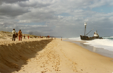
Photograph - Dageraad, 1981
... Colour photograph of the fishing vessel Dagaraad aground on the ninety mile beach beside the entrance bar. Camera crew interviewing a lady on beach with vessel in background, two children also in photo. ...Lakes Entrance Historical Society 4 Marine Parade Lakes Entrance gippsland Vessel stranded 26 April 1981 Ships and Shipping Fishing Industry Coast Shipwrecks Colour photograph of the fishing vessel Dagaraad aground on the ninety mile beach beside the entrance bar. Camera crew interviewing a lady on beach with vessel in background, two children also in photo. ...Vessel stranded 26 April 1981Colour photograph of the fishing vessel Dagaraad aground on the ninety mile beach beside the entrance bar. Camera crew interviewing a lady on beach with vessel in background, two children also in photo. Lakes Entrance Victoriaships and shipping, fishing industry, coast, shipwrecks -
 Lakes Entrance Historical Society
Postcard - Easter Pier beach, Then and Now Lakes Entrance Victoria 1910 and 1992, 1910c and 1992
... Black and white copy of postcard showing people sitting on beach, children wading in water on ninety mile beach near Eastern pier Lakes Entrance Victoria 1910. ...People Beaches Local History Black and white copy of postcard showing people sitting on beach, children wading in water on ninety mile beach near Eastern pier Lakes Entrance Victoria 1910. ...Paired photographs used in the 150 years Lakes Entrance 1858 to 2008 display held in 2008. Black and white copy of postcard showing people sitting on beach, children wading in water on ninety mile beach near Eastern pier Lakes Entrance Victoria 1910. Second black and white photograph taken at same location in 1992people, beaches, local history -
 Lakes Entrance Historical Society
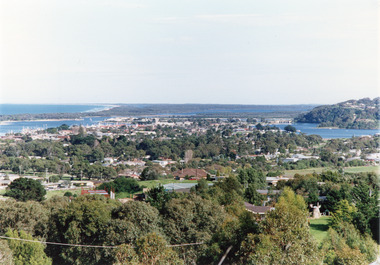
Photograph - Views of Lakes Entrance Victoria c1990, Tambo Shire
... Color photograph of the township, showing a distant view of the Ninety Mile Beach, the Gippsland Lakes and islands, Kalimna Heights, the bridge over the North Arm, Cunninghame Arm, and a broad view of the town and tree lined streets. ...Also second copy photographic enlargements of significant sites in the Tambo Shire Bridges Topography Township Waterways Color photograph of the township, showing a distant view of the Ninety Mile Beach, the Gippsland Lakes and islands, Kalimna Heights, the bridge over the North Arm, Cunninghame Arm, and a broad view of the town and tree lined streets. ...Also second copy photographic enlargements of significant sites in the Tambo ShireColor photograph of the township, showing a distant view of the Ninety Mile Beach, the Gippsland Lakes and islands, Kalimna Heights, the bridge over the North Arm, Cunninghame Arm, and a broad view of the town and tree lined streets. Lakes Entrance Victoriabridges, topography, township, waterways -
Lakes Entrance Historical Society
Domestic object - Light Fitting c1930, c1930
... Light fitting was in the house at Ninety Mile Beach Caravan Park which was moved from Lakes Entrance near corner of Esplanade and Myers Street by Alex and Bessie Larkin who established the caravan park now known as Lakes Beachfront Holiday Retreat....Light fitting was in the house at Ninety Mile Beach Caravan Park which was moved from Lakes Entrance near corner of Esplanade and Myers Street by Alex and Bessie Larkin who established the caravan park now known as Lakes Beachfront Holiday Retreat. ...Light fitting was in the house at Ninety Mile Beach Caravan Park which was moved from Lakes Entrance near corner of Esplanade and Myers Street by Alex and Bessie Larkin who established the caravan park now known as Lakes Beachfront Holiday Retreat.Small opaque light fitting half globe hung on chain and metal framecaravan parks