Showing 65 items matching north melbourne kangaroos
-
 Eltham District Historical Society Inc
Photograph - Digital Photograph, Alan King, The Robins, 13 Kangaroo Ground-Warrandyte Road, North Warrandyte, 2 March 2008
Built by noted artist Theodore Penleigh Boyd, father of architect Robin Boyd. Covered under National Estate, National Trust of Australia (Victoria) Local Significance and Heritage Overlay, Nillumbik Planning Scheme. Published: Nillumbik Now and Then / Marguerite Marshall 2008; photographs Alan King with Marguerite Marshall.; p111This collection of almost 130 photos about places and people within the Shire of Nillumbik, an urban and rural municipality in Melbourne's north, contributes to an understanding of the history of the Shire. Published in 2008 immediately prior to the Black Saturday bushfires of February 7, 2009, it documents sites that were impacted, and in some cases destroyed by the fires. It includes photographs taken especially for the publication, creating a unique time capsule representing the Shire in the early 21st century. It remains the most recent comprehenesive publication devoted to the Shire's history connecting local residents to the past. nillumbik now and then (marshall-king) collection, kangaroo ground-warrandyte road, north warrandyte, the robins -
 Glen Eira Historical Society
Ephemera - Bayside Regional Tennis Association
Brochure showing fixtures for winter 2001, office bearers, courts and locations, and by laws relevant to the competitions.tennis, st. patrick’s murrumbeena, murrumbeena, st. giles, ormond, alma, wilks street, caulfield north, tennis courts, tennis players, pelling road, centenary park, bentleigh east, dorman jenny, bentleigh, arthur street, kangaroo road, grieves meryl, elwood park, kings park, duff susan, milne anne, st. joseph’s elsternwick, sandham street, sheehy audrey, downshire road -
Glen Eira Historical Society
Plan - Nettalie
An A4 photocopy of the 'Plan of the Caulfield Road District' dated 1867. This plan shows the location of the properties owned by A Shaw and Blundell on Balaclava and Orrong Roads where Nettalie is situated. The plan includes all the landowners listed where their property was, the street names and other landmarks of 1867 including railways, hotels and reserves.caulfield, caulfield north, elsternwick, st kilda east, parish of prahran, parish of moorabbin, caulfield road district, melbourne and brighton railway, rosstown railway, elsternwick railway station, caulfield railway station, rosstown railway station, murrumbeena railway station, baptist church, paddy’s swamp reserve, cemetery reserve, leman swamp reserve, caulfield racecourse reserve, brighton cemetery, the vine caulfield hotel, the tam o’shanter hotel, melbourne hunt hotel, royal hotel, hotham street, horne street, nepean highway, north road, orrong road, dandenong road, princes highway, kooyong road, alma road, inkerman road, balaclava road, glen eira road, glen huntly road, hawthorn road, cemetery road, bambra road, redan road, kambrook road, neerim road, booran road, racecourse road, grange road, koornang road, murrumbeena road, crosbie road, kangaroo road, poath road, ford w, lempriere, cople j, riddell j c, manifold j, testar t, billing r h, semple, blundell, shaw a, butchart g, stephen j w, stephen g sir, hart j, duncan g, blackie r, stephen f, mccombie t, woollaston h, higgins j, lloyd j c, daish j, mcleod j, hughes d, wilson a, jamieson g, webb g h, renwick s, pennington h, dunn j, kirkpatrick w, ricketson w, toad a, sayce j, watts t, widgery, store, guess j, anketell j, clack j, sissen w, clayton g, dickson d, bevan j, hart t, anderson j, hart mrs, webb h, masters s, waghorn j, hemming c, hiam c, farquhar w, newing t, payne t, cooper r, snipe s, chambers j, forster w, summers r, harriman b, warrick, o’connell, long j, peck r, cochrane c, murray ross w, evans c, kennedy j, maclean n, forster, lyall w, dean j, newton h, looker w, baker c, johnston, crosbie j, kerr, jones, parr, nelson c, montgomery l, parsons w, james j c, sibon c, smith sydney w, plans, maps, land subdivisions, land use, settlements, roads and streets, hotels, churches, police stations, post offices, land surveys, railway stations, railways, schoolhouses, commerce, clergy residences, official buildings, local government, road districts -
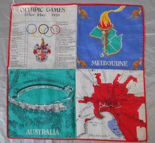 Bendigo Historical Society Inc.
Textile - 1956 Olympics Ladies' handkerchief
The 1956 Summer Olympics, officially known as the Games of the XVI Olympiad, were an international multi-sport event held in Melbourne, Victoria, Australia, from 22 November to 8 December 1956, with the exception of the equestrian events, which were held in Stockholm, Sweden, in June 1956. These Games were the first to be staged in the Southern Hemisphere and Oceania, as well as the first to be held outside Europe and North America. Handkerchief produced as a souvenir for the 1956 Melbourne Olympics. Synthetic fabric. The handkerchief s bordered in red thread and divided into four squares of contrasting colours. 1. A table of main events and ceremonies, Olympic rings and symbol. 2. Map of Australia (green) with an Olympic torch and kangaroos in each corner. 3 An image of the main stadium. caption "AUSTRALIA" in white on a green background. 4. Map of Melbourne in red with connecting road and rail links to other parts of Victoria. 1956 olympics, handkerchief -
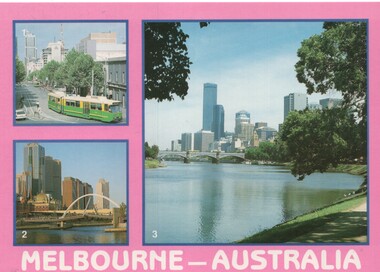 Melbourne Tram Museum
Postcard, Wayne Zerbe / North Australian Trading Co. for Kangaroo Gifts, Melbourne views including trams, early 1990's
Colour postcard, three panels: 1 - B class turning from Bourke into Spring St 2 - Walkway bridge (Evan Walker Bridge) over the Yarra 3 - City Skyline Back has space for name and address, stamp and a message and details of the postcard. Produced by Wayne Zerbe / North Australian Trading Co. for Kangaroo Gifts. Card No. KGL8 Has "Melbourne Australia" along the bottom edge.trams, tramways, bourke st, b class, melbourne