Showing 171 items matching "north east gold"
-
 Kiewa Valley Historical Society
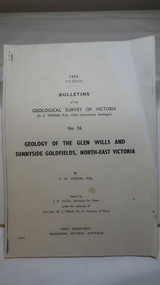
Document - Four Geological reports on the North-east Goldfields, Geological Survey of Victoria 1958 Bulletin
... geology in the north-east...gold...The mines are in the Bogong Alpine Area. geology in the north-east gold fields goldmines glen wills Foolscap printed Victorian Bulletins. ...Geological Surveys of N.E. Goldfields Victoria included mines and tunnels. A resurvey of goldfields was necessary to re-assess economic possibilities using modern techniques and structural interpretation. It included an examination of a considerable surface area with maps and underground workings. Results were correlated and integrated and published by the Mines Department.The mines are in the Bogong Alpine Area.Foolscap printed Victorian Bulletins. Each stapled in the top left corner and each with varying number of pages. Covering 1941-1958 a) Glen Wills and Sunnyside b) Sunnyside Tunnel c) Red Robin d) Maud and Yellow Girl Government Printer, Mines Department, Melbourne, Victoriageology in the north-east, gold fields, goldmines, glen wills -
 The Beechworth Burke Museum
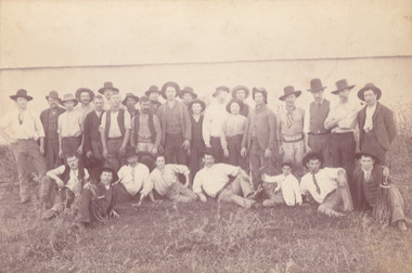
Photograph
... ...north east gold...This image is of important historical significance for its ability to convey information about society at the time, regarding fashion (which can potentially reveal social status) and mining in Beechworth in 1900. quartz north east gold sluicing gold sluicing hydraulic sluicing mining gold mining north-east victoria beechworth burke museum 1900 group miners hats vests ties wild shrubs tin quartz mining Reverse: BMM 8032/ Group(?) ...The photograph, captured around 1900, depicts a large group of minors located in Beechworth. Importantly, this photograph can provide information into the clothing and fashion of minors during this period of history. These men wear loose fitting shirts which are mostly a pale white colour, several wear vests and/or jackets and loose fitting trousers with boots. The majority of men wear wide brimmed hats to protect their skin and eyes from the sunlight. One man has a wooden pipe in his mouth and a few have ties/neckerchief's tied around their necks. The outfits of these miners has the potential to provide insight into their social status, these men are all dressed equally which provides the notion that they are of equal societal standing. The outfits of these miners dating to the 1900s is not dissimilar to photographs of those captured in the 1880s. The location of this photograph is not easy to interpret, but the photograph is recorded to have been taken in the Beechworth region. Displayed in this image is some wild shrubbery and grass where the men are standing/sitting and behind the group is a tin wall or even tin building. At the end of 1899, companies were continuing to search for gold in Beechworth and the surrounds but these attempts were not overly successful. In the early 1900's Quartz mining was occurring but this was done by individuals or smaller parties. It is unclear if these men are mining for gold or for quartz.The search for gold is ingrained into the history of Victoria and therefore, the study of images like this one which portrays some of the miners who worked behind-the-scenes for these discoveries has the potential to reveal important information regarding society, fashion etc. The date when the photograph was taken is vague but it allows us to form a timeline of mining activities in the North East. This image is of important historical significance for its ability to convey information about society at the time, regarding fashion (which can potentially reveal social status) and mining in Beechworth in 1900. Black and white rectangular photograph printed on matte photographic paper mounted on board.Reverse: BMM 8032/ Group(?) Beechworth Mines about 1900/ 80quartz, north east gold, sluicing, gold sluicing, hydraulic sluicing, mining, gold mining, north-east victoria, beechworth, burke museum, 1900, group, miners, hats, vests, ties, wild shrubs, tin, quartz mining -
 The Beechworth Burke Museum
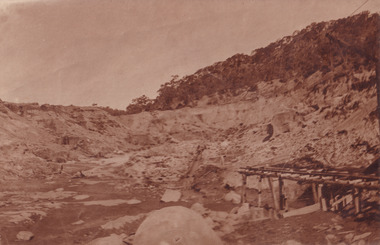
Photograph
... ...north east gold...gold and other materials. After the resources where drained, Wallace reaped the benefits of his mining business. Allan's Flat is located on the Yackandandah Creek, and is 10km north-east of Yackandandah and 20km south of Wodonga in Victoria's regional north-east. ...The Beechworth Burke Museum has additional images relating to gold sluicing and Allan's Flat which can be analysed and studied alongside images like this one. allan's flat north east gold sluicing gold sluicing hydraulic sluicing mining gold and quartz mine beechworth burke museum yackandandah Revers: Sluicing at Allan's Fort Sepia coloured retangular photograph printed on gloss photographic paper mounted on board. ...This photograph dating between the 1850s and early 1900s depicts an open cut sluicing site located in Allan's Flat looking upon the open cut from Staghorn Flat Number 1. Sluicing was undertaken in the area from 1850 to 1904. The image depicts a location mined by Yackandandah Sluicing Co. It portrays and open space with pipes laying on the ground and connected to pipes leaving the barge. These pipes were used to wash and seperate the qaurtz. There are two small buildings on high ground over looking the barge. Yackandandah Sluicing Co. was created by J.A. Wallace in the 1880s. The Yackandandah Sluicing Co. operated from the mid-1880s to the early 1900s, when resources eventually ran out. Open cut sluicing involved the use of high-powered hoses which used the centrifugal sand pump system (known as hydraulic sluicing) which broke down the soil which was then processed for quartz, gold and other materials. After the resources where drained, Wallace reaped the benefits of his mining business. Allan's Flat is located on the Yackandandah Creek, and is 10km north-east of Yackandandah and 20km south of Wodonga in Victoria's regional north-east. Allan's Flat was initially used to mine gold through alluvial methods, however that came to an end with little results. The mining business was then revived by J.A. Wallace with the introduction of hydraulic sluicing.The search for gold is ingrained into the history of Victoria and therefore, images like this one which portray an open cut sluicing site can reveal important information for society and technology for the date when the photograph was taken. This image is of important historical significance for its ability to convey information about sluicing and the methods used to find gold and other minerals in the lat 19th Century. It also shows a location where sluicing was undertook which provides insight into the impact of sluicing on the environment at a time when it was done. This image is important for current research into the history of Allan's Flat, a small regional location near Yackandandah in Victoria's North East. Therefore, this image has the capacity to be beneficial for research into society and the motivations of those living and working in this region during this period and therefore, has social significance. The Beechworth Burke Museum has additional images relating to gold sluicing and Allan's Flat which can be analysed and studied alongside images like this one.Sepia coloured retangular photograph printed on gloss photographic paper mounted on board.Revers: Sluicing at Allan's Fortallan's flat, north east gold, sluicing, gold sluicing, hydraulic sluicing, mining, gold and quartz mine, beechworth, burke museum, yackandandah -
 The Beechworth Burke Museum
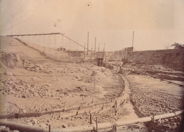
Photograph, 1910
... ...north east gold...From 1914 , four years after this image was captured, the company reformed to Cocks Pioneer Gold and Tin Mines NL (previously it was known as Cocks Pioneer Sluicing Co) and undertook large scale sluicing operations until 1929 and then 1934-1941. El Dorado is located on Reedy Creek and is surrounded by forested country to the north and east. ...The Beechworth Burke Museum has additional images relating to gold sluicing and El Dorado which can be analysed and studied alongside images like this one. el dorado north east gold sluicing gold sluicing hydraulic sluicing 1910 gold and tin mine open cut mining mining gold mining north-east victoria beechworth burke museum Obverse: COCKS PIONEER Q + T SL CO, N.L. / 1910 / LOOKING EAST UP OPEN CUT / FROM NO3 BARGE SITE / Reverse: 1997 . 2611 / A02611 Sepia coloured rectangular photograph printed on gloss photographic paper mounted on board. ...This photograph dating to 1910 depicts an open cut sluicing site located in El Dorado captured looking east up the open cut from the number 3 Barge site. Sluicing was undertaken in the area from 1900 to 1942 with some short breaks between these periods. The image depicts a location mined by Cocks Pioneer Gold and Tin Sluicing Company (as recorded on the annotation on the card mount). It portrays open cut rocks with a crevice in the center of the image where the sluicing was being undertaken. There is a small timber structure on the right of the image which could be an entrance to a mine or supports made of wood to prevent a cave in at the open cut site and above the cut rock there is bush. The timber structure has rail tracks on top of the bridge which could suggest the identification of this structure as a mine entrance. The rail tracks were used for little carts which hauled soil from the mine. The Cocks Pioneer Gold and Tin Mines N.L was one of El Dorado's two largest open cut sluicing mines of the 20th Century. The other was named the Cocks El Dorado Gold Dredging Company. The Cocks Pioneer Mines operated from 1901 until 1941 and found a total of 117,378 ounces of Gold and 1,673 tones of tin concentrates over these years. The Cocks company was formed in 1898 and operated until 1941. Open cut sluicing involved the use of high-powered hoses which used the centrifugal sand pump system (known as hydraulic sluicing) which broke down the soil which was then processed for gold and other precious metals. From 1914 , four years after this image was captured, the company reformed to Cocks Pioneer Gold and Tin Mines NL (previously it was known as Cocks Pioneer Sluicing Co) and undertook large scale sluicing operations until 1929 and then 1934-1941. El Dorado is located on Reedy Creek and is surrounded by forested country to the north and east. It is 20 km east of Wangaratta in Victoria's regional north-east. John Cock was the son of a Cornish minor who arrived in El Dorado in 1858. Cock founded his gold and tin mining company which ran successfully for many years in the El Dorado region. It was an open cut sluicing company because of the abandonment of underground mining after this was deemed too dangerous. In 1935 Cock's El Dorado Company commissioned the floating dredge which is still visible in El Dorado today. The dredge was built by the Thompson engineering works, Castlemaine, and weighed over 2,000 tones and today has a place on the Victorian Registers of historic buildings. Interestingly, the name El Dorado does not derive from the gold in the region, but from the Barambogie pastoral run completed by William Baker in 1840-1841. Gold was discovered in El Dorado 1854 but the gold was too deep for individual prospectors to find, it required the use of heavy machinery.The search for gold is ingrained into the history of Victoria and therefore, images like this one which portray an open cut sluicing site can reveal important information for society and technology for the date when the photograph was taken. This image is of important historical significance for its ability to convey information about sluicing and the methods used to find gold in 1910. It also shows a location where sluicing was undertook which provides insight into the impact of sluicing on the environment at a time when it was done. This image is important for current research into the history of El Dorado, a small regional location near Wangaratta in Victoria's North East. Therefore, this image has the capacity to be beneficial for research into society and the motivations of those living and working in this region during this period and therefore, has social significance. The Beechworth Burke Museum has additional images relating to gold sluicing and El Dorado which can be analysed and studied alongside images like this one.Sepia coloured rectangular photograph printed on gloss photographic paper mounted on board.Obverse: COCKS PIONEER Q + T SL CO, N.L. / 1910 / LOOKING EAST UP OPEN CUT / FROM NO3 BARGE SITE / Reverse: 1997 . 2611 / A02611el dorado, north east gold, sluicing, gold sluicing, hydraulic sluicing, 1910, gold and tin mine, open cut mining, mining, gold mining, north-east victoria, beechworth, burke museum -
 Chiltern Athenaeum Trust
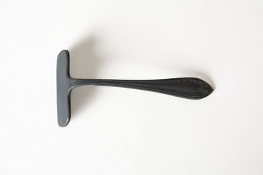
Domestic object - Child's food pusher, J. Biggin & Co, Unknown
... ...north-east victoria...gold...It may also be significant in understanding the customs and practices of English-speaking nations in the early Twentieth Century. w.c. busse wilfred clarence busse chiltern indigo shire north-east victoria gold fields gold mining gold rush table manners etiquette children childhood john biggin & co sheffield golden plague blue beyond historical fiction 1930s 1850s t.e. rofe henry lawson society electroplate tableware cutlery APEX EPNS AI The object is a metal food pusher, a child's eating utensil with a blunt lozenge at right angles to the handle. ...This children's eating utensil is believed to belong to the household of Chiltern writer and historian, W.C. Busse. The level of tarnish and the mark 'EPNS' may indicate it is electroplated. The blade also contains the maker's mark 'APEX', which was used by John Biggin & Co, Sheffield, United Kingdom. Pushers such as these were a common utensil in Victorian and early twentieth-century households. They were used to help children too young to use knives learn to eat politely at the table - the blunt blade was used to push food onto the fork. Pushers could also be used to pull food from a serving platter onto an individual plate. Wilfred Clarence Busse was born in Chiltern in 1898. He went to school at Wesley College in Melbourne, studied law at the University of Melbourne and became a barrister. Additionally, after spending time on a Victorian station in his early twenties, he wrote two historical novels about bush life. His first novel was 'The Blue Beyond: a Romance of the Early Days in South Eastern Australia', written in 1928 and published in 1930. Busse's second novel was titled 'The Golden Plague: A Romance of the Early Fifties'. The judges of the Henry Lawson Society's T.E. Rofe competition to advance Australian literature unanimously awarded it the Gold Medal in 1931 for the best historical novel of 1930. Newspaper articles about the award mention the writer's meticulous documentary and oral history research regarding life on the Gold Fields in the 1850s. It became a best-seller. Busse also wrote a series of articles about local history for "The Federal Standard" newspaper in Chiltern. He was a member of the Chiltern Athenaeum. He died in 1960.This child's eating utensil is significant for the detail it conveys of ordinary domestic life in the household of a significant Victorian writer with special reference to Chiltern and the surrounding region. It may also be significant in understanding the customs and practices of English-speaking nations in the early Twentieth Century. The object is a metal food pusher, a child's eating utensil with a blunt lozenge at right angles to the handle. The metal is tarnished, indicating that it may be silver or silverplated. APEX EPNS AI w.c. busse, wilfred clarence busse, chiltern, indigo shire, north-east victoria, gold fields, gold mining, gold rush, table manners, etiquette, children, childhood, john biggin & co, sheffield, golden plague, blue beyond, historical fiction, 1930s, 1850s, t.e. rofe, henry lawson society, electroplate, tableware, cutlery -
 Chiltern Athenaeum Trust
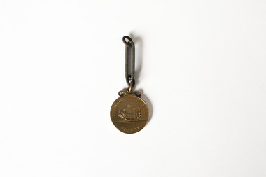
Medal
... ...north-east victoria...gold...Gold Fields in the 1850s. It became a best-seller. Busse also wrote a series of articles about local history for "The Federal Standard" newspaper in Chiltern. He was a member of the Chiltern Athenaeum. He died in 1960. This item is significant for the information it provides about the development of industry and local culture in Victoria in the 1880s. medal rutherglen agricultural show chiltern north-east victoria gold fields gold mining gold rush 1885 heirloom farming horticulture rutherglen historical society indigo shire wilfred clarence busse golden plague authors writers victorian writers victorian literature historical fiction blue beyond wesley college Federal Standard Inscription on obverse: Illegible Indistinct inscription on reverse may read: Rutherglen Agricultural Society Bronze coloured medal attached to single large-format chain link; embossed medal markings are indistinct but appear to show Coat of Arms on reverse side. ...This medal from the estate of W.C. Busse is believed to have been awarded to a recipient at the Rutherglen Agricultural Show in 1885. Due to degradation of the embossed markings, it is uncertain what the medal was awarded for or whom it was awarded to. It may have been awarded to a member of the Busse family prior to W.C. Busse's birth. Rutherglen is located approximately 18 kilometres from Chiltern. European agriculture and horticulture in the area was well established prior to the discovery of gold in the region in the 1860s. It held its first yearly Agricultural Show in 1880; in the present day it has a sister event focusing on showcasing the region's wines. Wilfred Clarence Busse was born in Chiltern in 1898. He went to school at Wesley College in Melbourne, studied law at the University of Melbourne and became a barrister. Additionally, after spending time on a Victorian station in his early twenties, he wrote two historical novels about bush life. His first novel was 'The Blue Beyond: a Romance of the Early Days in South Eastern Australia', written in 1928 and published in 1930. Busse's second novel was titled 'The Golden Plague: A Romance of the Early Fifties'. The judges of the Henry Lawson Society's T.E. Rofe competition to advance Australian literature unanimously awarded it the Gold Medal in 1931 for the best historical novel of 1930. Newspaper articles about the award mention the writer's meticulous documentary and oral history research regarding life on the Gold Fields in the 1850s. It became a best-seller. Busse also wrote a series of articles about local history for "The Federal Standard" newspaper in Chiltern. He was a member of the Chiltern Athenaeum. He died in 1960. This item is significant for the information it provides about the development of industry and local culture in Victoria in the 1880s. Bronze coloured medal attached to single large-format chain link; embossed medal markings are indistinct but appear to show Coat of Arms on reverse side. Inscription on obverse: Illegible Indistinct inscription on reverse may read: Rutherglen Agricultural Society medal, rutherglen agricultural show, chiltern, north-east victoria, gold fields, gold mining, gold rush, 1885, heirloom, farming, horticulture, rutherglen historical society, indigo shire, wilfred clarence busse, golden plague, authors, writers, victorian writers, victorian literature, historical fiction, blue beyond, wesley college, federal standard -
 Bendigo Historical Society Inc.
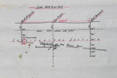
Plan - North Virginia, New Argus, East Clarence Gold Mines
... North Virginia, New Argus, East Clarence Gold Mines...gold...Bendigo...New Argus...North Virginia...East...Longitudinal section along reef line showing North Virginia, East Clarence and New Argus gold mines. 'Pitch of cap of New Argus Reef' handwritten on plan. ...Mines on plan were located in the Virginia Hill area of Eaglehawk. gold mining gold Bendigo New Argus North Virginia East Clarence gold mines Longitudinal section along reef line showing North Virginia, East Clarence and New Argus gold mines. ...Mines on plan were located in the Virginia Hill area of Eaglehawk. Longitudinal section along reef line showing North Virginia, East Clarence and New Argus gold mines. 'Pitch of cap of New Argus Reef' handwritten on plan. Scale printed on top of plan: '264 ft to an inch'. Plan forms part of the Margaret Roberts Collection.gold mining, gold, bendigo, new argus, north virginia, east clarence, gold mines -
 The Beechworth Burke Museum
Photograph, 2000
... Woolshed is a small area about five kilometres north west of Beechworth, and almost about 225km north east of Melbourne. When gold was discovered at the nearby Spring Creek in February 1852, Woolshed was one of three settlements set up to house miners and their families. ...The Beechworth Burke Museum Loch Street Beechworth high-country Woolshed is a small area about five kilometres north west of Beechworth, and almost about 225km north east of Melbourne. When gold was discovered at the nearby Spring Creek in February 1852, Woolshed was one of three settlements set up to house miners and their families. ...Woolshed is a small area about five kilometres north west of Beechworth, and almost about 225km north east of Melbourne. When gold was discovered at the nearby Spring Creek in February 1852, Woolshed was one of three settlements set up to house miners and their families. At its peak in 1857, Woolshed was also populated by 29 storekeepers and 14 hotels, as well as the Woolshed State School, which stood near where this photograph was taken. The school often played host to public meetings, as well as a public dance in 1897. The school was subject to some controversy in 1874 when one parent complained about the head of the school in the local newspaper, the Owens and Murray Advertiser, and at least three letters to the editor were exchanged between the two. According to the parent, C. O'Donoghue was not providing enough amusement for the children and was disrespectful to parents and staff. When the State Governor, Sir Reginald Talbot, visited Beechworth in 1906, the school organised a celebratory welcome. The Woolshed State School was ultimately closed in 1922 as miners had exhausted the Spring Creek gold supply and were moving elsewhere. This photograph, taken in about 2000, shows the trees that grew on or near the site of the original school. The Woolshed State School Honour Roll, with a list of the men from the school who served in the First World War, also still exists. It is stored in the Beechworth RSL as of 2015.This photograph is significant for its connection to an important site in Beechworth's gold mining history. Woolshed served a significant community of miners, with a population of at least 138 according to the 1911 census, with families that needed the school site to ensure their children's education. The image is also useful for prompting discussion about how Beechworth has changed over time, with the photograph taken 78 years after the school closed down.A colour rectangular photograph printed on glossy photographic paper.Woolshed State. / School site / 2000 / - remnant trees / / cobeechworth, burke museum, school, education, trees, nature, state school, woolshed, gold mining, teachers, over time, owens and murray advertiser, public meetings, public dance, c. o'donoghue, spring creek, state governor, sir reginald talbot, miners, honour roll, world war 1 -
 Warrnambool and District Historical Society Inc.
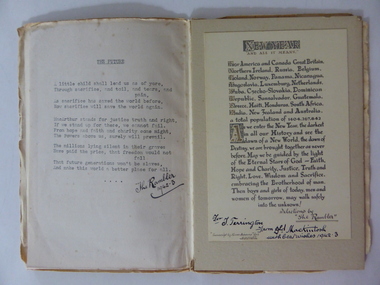
Card, Poems The Future The Rambler, 1942
... north east of Warrnambool) from Donald Mackintosh. Tom Terrington (b.1897) worked at various jobs until he took over the Framlingham store in the 1940s. He was a scholarly person with a wide knowledge of English literature. He wrote poetry and researched and wrote extensively on Framlingham history. Donald Mackintosh (1866-1951) was Australia’s first Olympic shooting gold...north east of Warrnambool) from Donald Mackintosh. Tom Terrington (b.1897) worked at various jobs until he took over the Framlingham store in the 1940s. He was a scholarly person with a wide knowledge of English literature. He wrote poetry and researched and wrote extensively on Framlingham history. Donald Mackintosh (1866-1951) was Australia’s first Olympic shooting gold ...These two items were sent in the 1940s to Tom Terrington of Framlingham (about 28 kilometres north east of Warrnambool) from Donald Mackintosh. Tom Terrington (b.1897) worked at various jobs until he took over the Framlingham store in the 1940s. He was a scholarly person with a wide knowledge of English literature. He wrote poetry and researched and wrote extensively on Framlingham history. Donald Mackintosh (1866-1951) was Australia’s first Olympic shooting gold medallist. He competed in trapshooting events all over the world, winning 30 gold medals, making a considerable amount of money and holding the world trapshooting championship title from 1903 to 1908. He was a keen photographer and wrote poetry under the name of ‘The Rambler’. This small folder is of great interest as it contains a poem sent to Tom Terrington by Donald Mackintosh (The Rambler). Tom Terrington is important in Framlingham’s history and his friendship with Donald Mackintosh, an Australian and world trapshooting champion and a poet is of considerable interest. The tone of the poem echoes also the despondency felt by Australians during the darkest days of World War Two. This is a piece of cream thickened paper folded in two with a typed copy of a poem pasted on the inside of the paper and a copy of a prose piece typed in ornate script and pasted on to a piece of cardboard and enclosed in the cream folder. Both of the typed items have handwritten messages at the bottom of the text. The cream folder is a little crumpled and stained. ‘The Rambler 1942-3’ ‘For T. Terrington from Dld Mackintosh with best wishes 1942-3’tom terrington, donald mackintosh -
 Warrnambool and District Historical Society Inc.
Certificate - Warrnambool Legacy Club to Shire of Warrnambool
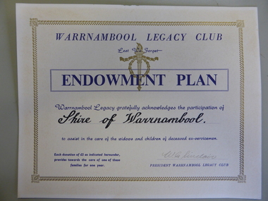
... north, and Camperdown, Timboon and Port Campbell in the south and east. The Warrnambool Legacy Club has contributed to the welfare of widows and children of past soldiers. In turn it has relied upon the generosity of local organisations and people to maintain their work. The Shire of Warrnambool would have been one of many of these groups who contributed in a generous way. warrnambool shire of warrnambool warrnambool legacy club legacy club endowment plan w g sinclair Signed by W.G. Sinclair. Cream card with gold ...Warrnambool Legacy Club was founded in 1947; prior to that it was part of Geelong Legacy Club. It covers an area in South West Victoria bounded by Port Fairy in the west, Mortlake, Derrinallum and Lismore to the north, and Camperdown, Timboon and Port Campbell in the south and east. The Warrnambool Legacy Club has contributed to the welfare of widows and children of past soldiers. In turn it has relied upon the generosity of local organisations and people to maintain their work. The Shire of Warrnambool would have been one of many of these groups who contributed in a generous way.Cream card with gold border. Dark blue printing with Warrnambool Legacy club at the top. Legacy logo printed in gold underneath.Signed by W.G. Sinclair. warrnambool, shire of warrnambool, warrnambool legacy club, legacy club endowment plan, w g sinclair -
 Kiewa Valley Historical Society
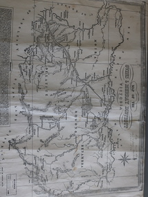
Map of the Ovens and Murray District of Victoria
... This map features the north-east and in particular, Beechworth where residents of the Kiewa Valley may have shopped or visited for appointments. Beechworth Black and white map with references to roads and gold. ...The map features Beechworth and its history.This map features the north-east and in particular, Beechworth where residents of the Kiewa Valley may have shopped or visited for appointments.Black and white map with references to roads and gold. The centre of the map is Beechworth and in the bottom left side of the map is the heading Beechworth with 12 lines of print of information regarding Beechworth. The Kiewa Valley is not identified.beechworth -
 Bendigo Military Museum
Badge - VARIOUS MILITARY BADGES, Unknown
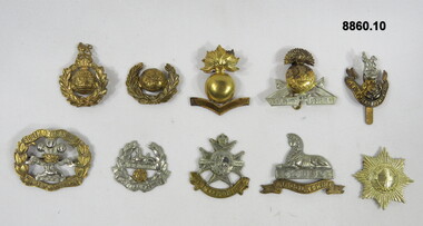
... gold, silver or brass colour with or without a backing mounting plate, pins. Sizes vary. 1. Royal Marines Hat. 2. Royal Marines Collar. 3. Royal Marines Artillery Cap for Lance Corporal 1850's - 1860's. 4. The Lancashire Fusiliers Hat. 5. Loyal North Lancashire Regt Hat WW1. 6. South Lancashire Regiment Hat. 7. East...gold, silver or brass colour with or without a backing mounting plate, pins. Sizes vary. 1. Royal Marines Hat. 2. Royal Marines Collar. 3. Royal Marines Artillery Cap for Lance Corporal 1850's - 1860's. 4. The Lancashire Fusiliers Hat. 5. Loyal North Lancashire Regt Hat WW1. 6. South Lancashire Regiment Hat. 7. East ...Military badges either gold, silver or brass colour with or without a backing mounting plate, pins. Sizes vary. 1. Royal Marines Hat. 2. Royal Marines Collar. 3. Royal Marines Artillery Cap for Lance Corporal 1850's - 1860's. 4. The Lancashire Fusiliers Hat. 5. Loyal North Lancashire Regt Hat WW1. 6. South Lancashire Regiment Hat. 7. East Lancashire Regiment Hat. 8. The Sherwood Foresters (Nottingham & Derbyshire Regt) Hat WW2. 9. Lincolnshire Regt Hat 1898-1948. 10. Coldstream Guards Hat. passchendaele barracks trust, pbt171to180, badges -
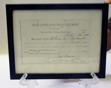 Orbost & District Historical Society
Certificate - share, 30/10/1940
... north of Club Terrace, within 2 miles of Errinundra River. The company registered in January 1898 and commenced crushing in September with a 10-head battery. In the first nine months’ yields totalled 1,418 oz from 972 tons.There was a tramway between the mine workings and the battery. The crusher from the Boulder Mine is now adjacent to the Slab Hut in Orbost. This document is a reference for gold mining and exploration in the Far East ...Share certificate issued by New Gippsland Boulder Mine - operating at Errinundra and receipt for Herbert, Eric W. Receipt is for amount of four pounds - signed by Bird, W. Prospectus was printed in 1934 at office of Snowy River Mail - 4 page booklet. Gold, copper and silver were the target minerals.The crusher from the Boulder Mine is now at the Slab Hut in Orbost. The first Gippsland Boulder Co.,was at Boulder Creek – 13 miles north of Club Terrace, within 2 miles of Errinundra River. The company registered in January 1898 and commenced crushing in September with a 10-head battery. In the first nine months’ yields totalled 1,418 oz from 972 tons.There was a tramway between the mine workings and the battery.The crusher from the Boulder Mine is now adjacent to the Slab Hut in Orbost. This document is a reference for gold mining and exploration in the Far East Gippsland area. The Herbert family has resided in Orbost since the late 19th century.Copy of New Gippsland Boulder Mine share certificate and receipt 1940. Framed in small black wooden frame.certificate-share-new-gippsland-boulder-mine mineralogy mining boulder-creek -
 Bright & District Historical Society operating the Bright Museum
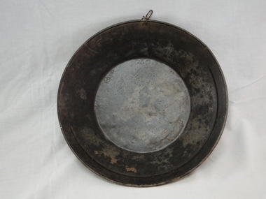
Pan gold
... Typical gold pan that would have been used in gold fields of North East Victoria gold gold pan goldfields Used gold pan. 300mm diameter Pan gold ...Used for separating gold particles from alluvial deposits. After washing the alluvial gravel in water the gold is trapped in a ring on the side of the pan. This pan has a ring half way round the rim of the pan.Typical gold pan that would have been used in gold fields of North East VictoriaUsed gold pan. 300mm diametergold, gold pan, goldfields -
 Federation University Historical Collection
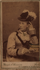
Photograph - Sepia photograph, Benson & Stevenson, Emma Eliza Jane Phillips, c1860's
... gold but instead of finding a fortune he worked for the Victorian Railways. After living in Sebastapol and Ballarat North they settled on a small farm at Yendon named "Gracedale" They were married in Ballarat at Saint Paul's Church of England in Ballarat East. ...gold but instead of finding a fortune he worked for the Victorian Railways. After living in Sebastapol and Ballarat North they settled on a small farm at Yendon named "Gracedale" They were married in Ballarat at Saint Paul's Church of England in Ballarat East. ...Emma was one of the first white children born in the Barrabool Hills (Geelong) to parents Richard and Elizabeth Phillips. Emma Eliza Jane Phillips was one of the first white children born in the Barrabool Hills (South Geelong) in the Port of New South Wales on 25/04/1844 and died at "Gracedale" Yendon 12/10/1925, age 81. Emma was the daughter of Richard Price Phillips and Elizabeth Anne Goodenough. Richard, originally a coach plater, was the licensee of "The Thistle Inn", a small hotel on the corner of Corio and Yarra Streets. Elizabeth appears to have had a dressmakers shop around the corner in Yarra Street. Emma married Thomas Watson in Ballarat in 18--? Thomas William Watson was born in Harston, Cambridge, England on10/11/1838 and died at "Gracedale", Yendon, Victoria, Australia 27/04/1920, age 81. He came to Australia seeking gold but instead of finding a fortune he worked for the Victorian Railways. After living in Sebastapol and Ballarat North they settled on a small farm at Yendon named "Gracedale" They were married in Ballarat at Saint Paul's Church of England in Ballarat East. Emma sang in the choir and was a member of the Ballarat Philharmonic Society. They first lived in Sebastapol, then Crompton Street, Ballarat North before building a house at Yendon. Thomas and Emma had 10 children, five boys and five girls, also rearing 3 grandchildren. Thomas and some of his sons ( including John Richard) helped to cut the original steps at Lal Lal to the bottom of the Lal Lal Falls.Photograph of a woman seated at a table with one elbow resting on books. Her jewllery has been hand painted in gold and the top book cover in green. C1860Front: Benson & Stevenson 108 Elizabeth Street Melbourne Copies can be obtained at any time Verso: Emma Eliza Jane (Phillips) Watson; 1844-1925; 81yrs; Died "Gracedale" Yendon, Vic; Born - South Geelong/Barrabool Hills; Dad's (John Richard Watson) motheremma eliza jane phillips, emma eliza jane watson, barrabool hills, yendon, thomas watson, richard price phillips, elizabeth goodenough, lal lal falls -
 Eltham District Historical Society Inc
Film - Video (VHS), Nillumbik Shire Council, The Nillumbik Story, 1996
... gold rush...Charles Reddington...Clifton Pugh...cottlesbridge...Cypress rows...developer...Diamond Creek...Diamond Creek Mine...Diamond Reef...Diamond Valley miniature railway...Doncaster...dunmoochin...Education program...EEPS...Eltham...Eltham East Primary School...Eltham East Primary School Band...Eltham Library Community Gallery...Eltham Lower Park...Environment...fishing...flour mill...fruit growing...fruiterer...Garden Hill...Gold mining...Green Wedge...Greensborough...Heritage Trail...Hurstbridge Railway Line...jazz festival...Jock Ryan...Kangaroo Ground...kangaroo ground tower...Kinglake...Maroondah Aqueduct...Matcham Skipper...Memorial Park...Ming Mackay (1918-2009)...Montsalvat...Mudbrick houses...Music...musicians...nesting area...Nillumbik Historical Society...Nillumbik Shire...North...CREDITS Music by John Greenfield from the CD Sweet Rain “The Snow Tree”, Uncle Music UNC 2001 Cameras - David Mirabella and Peter Farragher Editor – Olwyn Jones Written and Produced by Jason Cameron A Jason Cameron Proction for Nillumbik Shire Provides a record of the relatively newly created Shire of Nillumbik at the time and the features and attactions of the shire in its people arts, culture and environment video recording Arthurs Creek Arthurs Creek Landcare group Artists artists in residence Arts Arts Festival Authors BlackBerry Brock family Bulldozer Bulleen bushland sanctuary Caledonian gold rush Charles Reddington Clifton Pugh cottlesbridge Cypress rows developer Diamond Creek Diamond Creek Mine Diamond Reef Diamond Valley miniature railway Doncaster dunmoochin Education program EEPS Eltham Eltham East Primary School Eltham East Primary School Band Eltham Library Community Gallery Eltham Lower Park Environment fishing flour mill fruit growing fruiterer Garden Hill Gold mining Green Wedge Greensborough Heritage Trail Hurstbridge Railway Line jazz festival Jock Ryan Kangaroo Ground kangaroo ground tower Kinglake Maroondah Aqueduct Matcham Skipper Memorial Park Ming Mackay (1918-2009) Montsalvat Mudbrick houses Music musicians nesting area Nillumbik Historical Society Nillumbik Shire North Warrandyte Old timer Orchards Peter Brock Plenty River poets Population Recreation recreational activities revegetation Robert Hoddle Sandy Brock Shillinglaw Cottage Shire of Eltham War Memorial Sigmund Jorgensen St Andrews Hotel St Andrews Market Sugarloaf Reservoir Templestowe The Hill tourism Viewing platform Warrandyte water catchment area Watsons Creek Wedgetail eagle Whittlesea Wiregrass Gallery Wurundjeri Yarra River Jack Powell VHS Cassette (five copies) DVD (one copy) Converted to MP4 file format 0:22:00, 1.60GB The Nillumbik Story Film Video (VHS) Nillumbik Shire Council Jason Cameron David Mirabella Peter Farragher Olwyn Jones ...PART 1 – NILLUMBIK (00:00-07:17) Opening features various scenes around Nillumbik Shire. For 40,000 years Nillumbik was the home of the Wurundjeri people. Robert Hoddle gave the district its name. Jock Ryan, then president of Nillumbik Historical Society discusses the names Nillumbik and Diamond Creek. In the late 1830s white occupation began with gold found in Warrandyte in 1851 and 12 years later at Diamond Creek -the Diamond Reef which led to the Caledonian gold rush. Jock Ryan discusses the Diamond Creek mine, which was thriving until it burnt out in 1915. Large numbers of workmen moved into area in late 1870s to construct the Maroondah Aqueduct. With growing population of Melbourne, the nearby Yan Yean system had severely disrupted the flow of the Plenty River, forcing the closure of three flour mills there. The aqueduct came to the rescue carrying water 66km from Healesville to Preston. When the Diamond Creek gold mine burnt down the local economy suffered but fruit growing industry had already been established and Diamond Creek became a thriving fruit growing centre. Interview with Jack Powell, a long-time fruiterer at St Andrews market, his family had lived in the area for a hundred years, 3 to 4 generations, “a lot of hard work”. By the time the railway arrived fruit growing was no longer competitive. The railway brought the city closer and day trippers. The Green Wedge separates the shire from the more densely developed neighbours such as Whittlesea, Doncaster, Templestowe, Bulleen and Greensborough. Population at the time (1996) was 19,000 but links to the past remain strong. Mudbrick houses along the Heritage Trail The saving of Shillinglaw Cottage from demolition in 1963 and relocation brick by brick. PART 2 – ENVIRONMENT (07:18-14:44) Peter Brock (with Bev Brock in background) at St Andrews market discusses his childhood growing up in the district and the environment and the values it instilled upon him and his own family. The Brocks have been in the district since the 1860s. Nillumbik Shire responsible for managing three catchment areas; Diamond Creek, Arthurs Creek and Watsons Creek. Follows the course of the Diamond Creek commencing in Kinglake through the district to its confluence with the Yarra River at Eltham at Eltham Lower Park. Highlights Eltham Lower Park community revegetation program and the newly constructed (1996) viewing platform built of new and recycled timbers at the confluence of the Diamond Creek and Yarra River. Also featured are outdoor recreation on the river and at Eltham Lower Park including the Diamond Valley miniature railway. Sugarloaf reservoir and recreational activities and fishing. Aerial view of Memorial Park and Shire of Eltham War Memorial tower at Garden Hill, Kangaroo Ground. Significant tourism opportunities for the shire with 3 million potential day-trippers in metropolitan Melbourne. Council and community working together to find a way to promote the shires natural and artistic assets. At Arthurs Creek, the Brock family and neighbours working together to take care of their waterway. Peter Brock’s uncle, Sandy Brock talks about environmental management and the Arthurs Creek Landcare group and actions to eradicate blackberry problem. Having previously planted Cypress rows they are replacing them with indigenous species to improve the water supply, keeping cattle out of the creek bed to improve the quality downstream flowing into the Yarra. Eltham East Primary School Band playing “All things bright and beautiful” merges into scenes of the bushland sanctuary set aside by the school in 1980 with unidentified teacher discusses the sanctuary and their education program and school children’s comments. Plight of a family of Wedgetail eagles nesting in the path of a developer’s bulldozer at North Warrandyte and actions to save their nesting areas. PART 3 – ARTS (14:45-22:00) Arts and Jazz festival at Montsalvat featuring interviews with Sigmund Jorgensen discussing Montsalvat and its principles. Also Matcham Skipper. Clifton Pugh’s funeral at Montsalvat and his legacy at Dunmoochin near Cottlesbridge with artists in residence, at the time, Chicago artist Charles Reddington who discusses the benefits of the experience. An unidentified female artist also talks about the program and why people are drawn to the area. Unidentified man on street talking about the amount of talent in the area, artists, poets, musicians, authors. Artist Ming Mackay (1918-2009) interviewed talking about the people she mixes with on “the Hill”. Works of local artists are displayed Eltham Library Community Gallery and Wiregrass gallery with a new coffee shop at the Wiregrass making it an even more popular destination. Music at St Andrews Hotel (may be a little bit country) and the Saturday market where likely to hear anything. Sellers and patrons at the market asked about what attracts them to the market and where they came from. Scenes of poets/authors giving readings. CREDITS Music by John Greenfield from the CD Sweet Rain “The Snow Tree”, Uncle Music UNC 2001 Cameras - David Mirabella and Peter Farragher Editor – Olwyn Jones Written and Produced by Jason Cameron A Jason Cameron Proction for Nillumbik ShireProvides a record of the relatively newly created Shire of Nillumbik at the time and the features and attactions of the shire in its people arts, culture and environmentVHS Cassette (five copies) DVD (one copy) Converted to MP4 file format 0:22:00, 1.60GBvideo recording, arthurs creek, arthurs creek landcare group, artists, artists in residence, arts, arts festival, authors, blackberry, brock family, bulldozer, bulleen, bushland sanctuary, caledonian gold rush, charles reddington, clifton pugh, cottlesbridge, cypress rows, developer, diamond creek, diamond creek mine, diamond reef, diamond valley miniature railway, doncaster, dunmoochin, education program, eeps, eltham, eltham east primary school, eltham east primary school band, eltham library community gallery, eltham lower park, environment, fishing, flour mill, fruit growing, fruiterer, garden hill, gold mining, green wedge, greensborough, heritage trail, hurstbridge railway line, jazz festival, jock ryan, kangaroo ground, kangaroo ground tower, kinglake, maroondah aqueduct, matcham skipper, memorial park, ming mackay (1918-2009), montsalvat, mudbrick houses, music, musicians, nesting area, nillumbik historical society, nillumbik shire, north warrandyte, old timer, orchards, peter brock, plenty river, poets, population, recreation, recreational activities, revegetation, robert hoddle, sandy brock, shillinglaw cottage, shire of eltham war memorial, sigmund jorgensen, st andrews hotel, st andrews market, sugarloaf reservoir, templestowe, the hill, tourism, viewing platform, warrandyte, water catchment area, watsons creek, wedgetail eagle, whittlesea, wiregrass gallery, wurundjeri, yarra river, jack powell -
 Eltham District Historical Society Inc
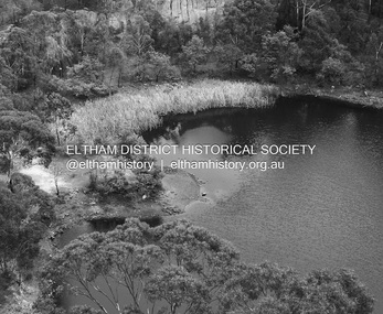
Photograph - Digital Photograph, Alan King, Blue Lake, Plenty Gorge Park, 2008
... Gold discoveries in the early 1850s swelled the population, particularly around Smugglers Gully; but food production made more of an impact. In the late 1850s wheat production supplanted grazing. In the 1860s the government made small holdings available to poorer settlers. These had the greatest effect on the district, particularly in Doreen and Yarrambat, where orchards were established from the 1880s to 1914. Links with a prominent early family are the remains of Stuchbery Farm, by the river’s edge bounded by Smugglers Gully to the north and La Trobe Road, Yarrambat, to the east...Gold discoveries in the early 1850s swelled the population, particularly around Smugglers Gully; but food production made more of an impact. In the late 1850s wheat production supplanted grazing. In the 1860s the government made small holdings available to poorer settlers. These had the greatest effect on the district, particularly in Doreen and Yarrambat, where orchards were established from the 1880s to 1914. Links with a prominent early family are the remains of Stuchbery Farm, by the river’s edge bounded by Smugglers Gully to the north and La Trobe Road, Yarrambat, to the east ...A quarry was transformed into the Blue Lake. Published: Nillumbik Now and Then / Marguerite Marshall 2008; photographs Alan King with Marguerite Marshall.; p179 The dramatic steep-sided Plenty Gorge lies along the divide of two geological areas, and separates the Nillumbik Shire and the City of Whittlesea. On the Nillumbik side are undulating hills and sedimentary rock, and in Whittlesea, lies a basalt plain formed by volcanic action up to two million years ago. This provides the Plenty Gorge Park with diverse vegetation and habitats, making it one of Greater Melbourne’s most important refuges for threatened and significant species. The park, established in 1986, consists of around 1350 hectares, and extends 11 kilometres along the Plenty River, from Greensborough to Mernda. It provides a wildlife corridor for around 500 native plant and 280 animal species. The area’s plentiful food and water attracted the Wurundjeri Aboriginal people and then European settlers. By 1837 squatters had claimed large runs of land for their sheep and cattle. The Plenty Valley was among the first in the Port Phillip District to be settled - mainly in the less heavily timbered west - and was proclaimed a settled district in 1841.But by the late 1880s, the settlers’ extensive land clearing for animal grazing, then agriculture, depleted the Wurundjeri’s traditional food sources, which helped to drive them away. Many Wurundjeri artefacts remain (now government protected), and so far 57 sites have been identified in the park, including scarred trees, burial areas and stone artefacts. Pioneer life could be very hard because of isolation, flooding, bushfires and bushrangers. Following the Black Thursday bushfires of 1851, basalt was quarried to build more fire-resistant homes. Gold discoveries in the early 1850s swelled the population, particularly around Smugglers Gully; but food production made more of an impact. In the late 1850s wheat production supplanted grazing. In the 1860s the government made small holdings available to poorer settlers. These had the greatest effect on the district, particularly in Doreen and Yarrambat, where orchards were established from the 1880s to 1914. Links with a prominent early family are the remains of Stuchbery Farm, by the river’s edge bounded by Smugglers Gully to the north and La Trobe Road, Yarrambat, to the east. The Stuchberys moved to the valley in 1890, and the family still lives in the area. In 1890, Alfred and Ada first lived in a tent where four children were born, then Alfred built the house and outbuildings around 1896. They planted an orchard, then a market garden, and developed a dairy. The family belonged to the local Methodist and tennis communities. Their grandson Walter, opened the Flying Scotsman Model Railway Museum in Yarrambat, which his widow, Vi, continues to run. Wal was also the Yarrambat CFA Captain for 22 years until 1987. Walter sold 24 hectares in 1976 for development - now Vista Court - and in 1990, the remaining 22.6 hectares for the park. Remaining are an early stone dairy and remnants of a stone barn, a pig sty and a well. Until it was destroyed by fire in 2003, a slab hut stood on the Happy Hollow Farm site, at the southern end of the park. The hut is thought to have been built in the Depression around 1893. This was a rare and late example of a slab hut with a domestic orchard close to Melbourne. Emmet Watmough and his family first occupied the hut, followed by a succession of families, until the Bell family bought it around 1948. There they led a subsistence lifestyle for 50 years, despite encroaching Melbourne suburbia. The Yellow Gum Recreation Area includes the Blue Lake, coloured turquoise at certain times of the year. Following the 1957 bushfires, this area was quarried by Reid Quarries Pty Ltd for Melbourne’s first skyscrapers, then by Boral Australia. However in the early 1970s water began seeping into the quarry forming the Blue Lake and the quarry was closed. The State Government bought the site in 1997 and opened it as a park in 1999.This collection of almost 130 photos about places and people within the Shire of Nillumbik, an urban and rural municipality in Melbourne's north, contributes to an understanding of the history of the Shire. Published in 2008 immediately prior to the Black Saturday bushfires of February 7, 2009, it documents sites that were impacted, and in some cases destroyed by the fires. It includes photographs taken especially for the publication, creating a unique time capsule representing the Shire in the early 21st century. It remains the most recent comprehenesive publication devoted to the Shire's history connecting local residents to the past. nillumbik now and then (marshall-king) collection, blue lake, plenty gorge park -
 Eltham District Historical Society Inc
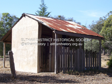
Photograph - Digital Photograph, Marguerite Marshall, Stuchbery Farm dairy, 14 March 2008
... Gold discoveries in the early 1850s swelled the population, particularly around Smugglers Gully; but food production made more of an impact. In the late 1850s wheat production supplanted grazing. In the 1860s the government made small holdings available to poorer settlers. These had the greatest effect on the district, particularly in Doreen and Yarrambat, where orchards were established from the 1880s to 1914. Links with a prominent early family are the remains of Stuchbery Farm, by the river’s edge bounded by Smugglers Gully to the north and La Trobe Road, Yarrambat, to the east...Gold discoveries in the early 1850s swelled the population, particularly around Smugglers Gully; but food production made more of an impact. In the late 1850s wheat production supplanted grazing. In the 1860s the government made small holdings available to poorer settlers. These had the greatest effect on the district, particularly in Doreen and Yarrambat, where orchards were established from the 1880s to 1914. Links with a prominent early family are the remains of Stuchbery Farm, by the river’s edge bounded by Smugglers Gully to the north and La Trobe Road, Yarrambat, to the east ...Stuchbery Farm was situated on the Plenty River bounded by Smugglers Gully to the north and La trobe Road, Yarrambat, to the east. Alan and Ada Stutchbery moved to the valley in 1890, first living in a tent where four children were born. Alfred built a home and outbuildings around 1896. They planted an orchard, then a market garden and developed a dairy. Published: Nillumbik Now and Then / Marguerite Marshall 2008; photographs Alan King with Marguerite Marshall.; p179 The dramatic steep-sided Plenty Gorge lies along the divide of two geological areas, and separates the Nillumbik Shire and the City of Whittlesea. On the Nillumbik side are undulating hills and sedimentary rock, and in Whittlesea, lies a basalt plain formed by volcanic action up to two million years ago. This provides the Plenty Gorge Park with diverse vegetation and habitats, making it one of Greater Melbourne’s most important refuges for threatened and significant species. The park, established in 1986, consists of around 1350 hectares, and extends 11 kilometres along the Plenty River, from Greensborough to Mernda. It provides a wildlife corridor for around 500 native plant and 280 animal species. The area’s plentiful food and water attracted the Wurundjeri Aboriginal people and then European settlers. By 1837 squatters had claimed large runs of land for their sheep and cattle. The Plenty Valley was among the first in the Port Phillip District to be settled - mainly in the less heavily timbered west - and was proclaimed a settled district in 1841. But by the late 1880s, the settlers’ extensive land clearing for animal grazing, then agriculture, depleted the Wurundjeri’s traditional food sources, which helped to drive them away. Many Wurundjeri artefacts remain (now government protected), and so far 57 sites have been identified in the park, including scarred trees, burial areas and stone artefacts. Pioneer life could be very hard because of isolation, flooding, bushfires and bushrangers. Following the Black Thursday bushfires of 1851, basalt was quarried to build more fire-resistant homes. Gold discoveries in the early 1850s swelled the population, particularly around Smugglers Gully; but food production made more of an impact. In the late 1850s wheat production supplanted grazing. In the 1860s the government made small holdings available to poorer settlers. These had the greatest effect on the district, particularly in Doreen and Yarrambat, where orchards were established from the 1880s to 1914. Links with a prominent early family are the remains of Stuchbery Farm, by the river’s edge bounded by Smugglers Gully to the north and La Trobe Road, Yarrambat, to the east. The Stuchberys moved to the valley in 1890, and the family still lives in the area. In 1890, Alfred and Ada first lived in a tent where four children were born, then Alfred built the house and outbuildings around 1896. They planted an orchard, then a market garden, and developed a dairy. The family belonged to the local Methodist and tennis communities. Their grandson Walter, opened the Flying Scotsman Model Railway Museum in Yarrambat, which his widow, Vi, continues to run. Wal was also the Yarrambat CFA Captain for 22 years until 1987. Walter sold 24 hectares in 1976 for development - now Vista Court - and in 1990, the remaining 22.6 hectares for the park. Remaining are an early stone dairy and remnants of a stone barn, a pig sty and a well. Until it was destroyed by fire in 2003, a slab hut stood on the Happy Hollow Farm site, at the southern end of the park. The hut is thought to have been built in the Depression around 1893. This was a rare and late example of a slab hut with a domestic orchard close to Melbourne. Emmet Watmough and his family first occupied the hut, followed by a succession of families, until the Bell family bought it around 1948. There they led a subsistence lifestyle for 50 years, despite encroaching Melbourne suburbia. The Yellow Gum Recreation Area includes the Blue Lake, coloured turquoise at certain times of the year. Following the 1957 bushfires, this area was quarried by Reid Quarries Pty Ltd for Melbourne’s first skyscrapers, then by Boral Australia. However in the early 1970s water began seeping into the quarry forming the Blue Lake and the quarry was closed. The State Government bought the site in 1997 and opened it as a park in 1999.This collection of almost 130 photos about places and people within the Shire of Nillumbik, an urban and rural municipality in Melbourne's north, contributes to an understanding of the history of the Shire. Published in 2008 immediately prior to the Black Saturday bushfires of February 7, 2009, it documents sites that were impacted, and in some cases destroyed by the fires. It includes photographs taken especially for the publication, creating a unique time capsule representing the Shire in the early 21st century. It remains the most recent comprehenesive publication devoted to the Shire's history connecting local residents to the past. nillumbik now and then (marshall-king) collection, ada stuchbery, alan stuchbery, dairy, stuchbery farm, farm buildings, yarrambat, plenty gorge park -
 Eltham District Historical Society Inc
Photograph, Fay Bridge, Ruins beside the Diamond Creek at Wattle Glen, 13 October 2016
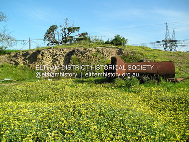
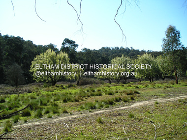
... north and to the east side of the mound. NHS is not sure how much or which part of the surrounding area was covered by the barns but they were large enough to hold dances after the race meetings that were held in the late 1880's on the adjacent creek flats. It would make sense with the lay of the land that they covered some of the ground to the north and east and used for farm storage, packing sheds for their apple and pear orchards and also for supporting the Nillumbik Gold Mine the family worked to the north up the gully. ...north and to the east side of the mound. NHS is not sure how much or which part of the surrounding area was covered by the barns but they were large enough to hold dances after the race meetings that were held in the late 1880's on the adjacent creek flats. It would make sense with the lay of the land that they covered some of the ground to the north and east and used for farm storage, packing sheds for their apple and pear orchards and also for supporting the Nillumbik Gold Mine the family worked to the north up the gully. ...The newly constructed Diamond Creek Trail from Diamond Creek to Wattle Glen completed in February 2021 winds around these ruins just pass the high transmission power lines near Herberts Lane and Collard Drive From Jean Verso, Nillumbik Historical Society, 15 April 2021 William Wandless Herbert bought the surrounding 100 acres in 1852. He was a native of Northumberland and the Scottish Borders who arrived in Melbourne in 1847. The house on the top of the mound would have been built not long after he bought the land; the farm was named "Greenhills". He married Elizabeth Wilson, daughter of John Wilson who had been in Diamond Creek since about 1846. Their first child was born in 1854 so there would be some form of dwelling from about that time. They had eight children who all survived to a good age. His will describes the house as part stone and part wood and of four rooms. Nillumbik Historical Society (NHS) believe it was one of the earliest if not the earliest house, in this part of the district. The remains of the stone house foundations are on top of the mound (photos on the VHD page) and the barn walls are on the north and to the east side of the mound. NHS is not sure how much or which part of the surrounding area was covered by the barns but they were large enough to hold dances after the race meetings that were held in the late 1880's on the adjacent creek flats. It would make sense with the lay of the land that they covered some of the ground to the north and east and used for farm storage, packing sheds for their apple and pear orchards and also for supporting the Nillumbik Gold Mine the family worked to the north up the gully. The path that comes down the gully and runs into the trail goes past the mine site which was on the west side of the gully a couple of hundred metres up from the flats. Heritage Victoria link for the site - https://vhd.heritagecouncil.vic.gov.au/places/12203fay bridge collection, 2016-10-13, diamond creek, diamond creek trail, ruins, wattle glen, william wandless herbert, greenhills, elizabeth wilson -
 Eltham District Historical Society Inc
Photograph, Fay Bridge, Remains of apple orchard near the Diamond Creek, Wattle Glen, 11 October 2018
... north and to the east side of the mound. NHS is not sure how much or which part of the surrounding area was covered by the barns but they were large enough to hold dances after the race meetings that were held in the late 1880's on the adjacent creek flats. It would make sense with the lay of the land that they covered some of the ground to the north and east and used for farm storage, packing sheds for their apple and pear orchards and also for supporting the Nillumbik Gold Mine the family worked to the north up the gully. ...north and to the east side of the mound. NHS is not sure how much or which part of the surrounding area was covered by the barns but they were large enough to hold dances after the race meetings that were held in the late 1880's on the adjacent creek flats. It would make sense with the lay of the land that they covered some of the ground to the north and east and used for farm storage, packing sheds for their apple and pear orchards and also for supporting the Nillumbik Gold Mine the family worked to the north up the gully. ...The newly constructed Diamond Creek Trail from Diamond Creek to Wattle Glen completed in February 2021 winds past these apple trees that possibly lined the entrance to the Greenhills property From Jean Verso, Nillumbik Historical Society, 15 April 2021 William Wandless Herbert bought the surrounding 100 acres in 1852. He was a native of Northumberland and the Scottish Borders who arrived in Melbourne in 1847. The house on the top of the mound would have been built not long after he bought the land; the farm was named "Greenhills". He married Elizabeth Wilson, daughter of John Wilson who had been in Diamond Creek since about 1846. Their first child was born in 1854 so there would be some form of dwelling from about that time. They had eight children who all survived to a good age. His will describes the house as part stone and part wood and of four rooms. Nillumbik Historical Society (NHS) believe it was one of the earliest if not the earliest house, in this part of the district. The remains of the stone house foundations are on top of the mound (photos on the VHD page) and the barn walls are on the north and to the east side of the mound. NHS is not sure how much or which part of the surrounding area was covered by the barns but they were large enough to hold dances after the race meetings that were held in the late 1880's on the adjacent creek flats. It would make sense with the lay of the land that they covered some of the ground to the north and east and used for farm storage, packing sheds for their apple and pear orchards and also for supporting the Nillumbik Gold Mine the family worked to the north up the gully. The path that comes down the gully and runs into the trail goes past the mine site which was on the west side of the gully a couple of hundred metres up from the flats. Heritage Victoria link for the site - https://vhd.heritagecouncil.vic.gov.au/places/12203fay bridge collection, 2018-10-11, diamond creek, diamond creek trail, elizabeth wilson, greenhills, wattle glen, william wandless herbert, apple trees -
 Bendigo Historical Society Inc.
Document - MCCOLL, RANKIN AND STANISTREET COLLECTION: WAGES BOOK, VARIOUS MINING COMPANIES, 1945-50
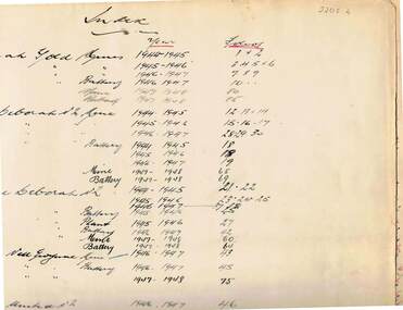
... Listing wages and tax paid for employees of : Deborah Gold Mines and batteries, North Deborah mine and batteries, Central Deborah mine and batteries,, Central Nell Gwynne, Deborah United No. 2, South Deborah, Deborah Extended, Nell Gwynne Reef, East Clarence, Golden Carshalton, North Virginia. ...Listing wages and tax paid for employees of : Deborah Gold Mines and batteries, North Deborah mine and batteries, Central Deborah mine and batteries,, Central Nell Gwynne, Deborah United No. 2, South Deborah, Deborah Extended, Nell Gwynne Reef, East Clarence, Golden Carshalton, North Virginia. ...Document: McColl, Rankin and Stanistreet: Deborah: wages book, various mining companies. Listing wages and tax paid for employees of : Deborah Gold Mines and batteries, North Deborah mine and batteries, Central Deborah mine and batteries,, Central Nell Gwynne, Deborah United No. 2, South Deborah, Deborah Extended, Nell Gwynne Reef, East Clarence, Golden Carshalton, North Virginia. Indexed in front cover.organization, mining, mccoll, rankin and stanistreet, mccoll, rankin and stanistreet: gold mining, deborah mines -
 Bendigo Historical Society Inc.
Document - LONG GULLY HISTORY GROUP COLLECTION: THE BENDIGO GOLDFIELD … INTRODUCTION TO FIELD
... North Red White and Blue... Central Red White and Blue... Little 180... John Brown Knitwear Factory... South Ironbark... Victoria Consols East Shaft... Ironbark... Manchester Arms Hotel... Unity Mine... Wattle Gully Mine Chewton... Hercules... Hercules and Energetic... Bendigo Amalgamated Goldfields Coy... Long Gully Post Office... The Old Wheal Owl... Central Nell Gwynne... Gold...History House 11 Mackenzie Street Bendigo goldfields BENDIGO History long gully history group The Long Gully History Group - The Bendigo Goldfield...Introduction to Field A Richardson New Chum Railway Mine The Dascombe Nugget The Victoria Nugget R R Haverfield Ballerstadt Rae Wittscheibe Lazarus Cave and Amos Geo Lansell The Old Chum Victoria Specimen Hustlers Bendigo Amalgamated Goldfields Bendigo Mines Limited Nell Gwynne Napoleon Carshalton The Deborah Roberts & Sons The North Deborah Williams' United Central Deborah Lansell's South Red White & Blue The New Red White and Blue Consolidated (Big Blue) Union H Harkness & Co Thompson & Co Lansell's Bendigo Battery Showgrounds Industrial Hall North Red White and Blue Central Red White and Blue Little 180 John Brown Knitwear Factory South Ironbark Victoria Consols East Shaft Ironbark Manchester Arms Hotel Unity Mine Wattle Gully Mine Chewton Hercules Hercules and Energetic Bendigo Amalgamated Goldfields Coy Long Gully Post Office The Old Wheal Owl Central Nell Gwynne Gold Mines Hotel Bendigo City Council Mr Jack Barker Bendigo and District Tourist Association The New Chum Syncline Courier of the Mines newspaper Camp Hill School Sandhurst East Post Office Bendigo Cemetery White Hills Cemetery Eaglehawk Cemetery Kangaroo Flat Cemetery Albert Richardson The Bendigo Goldfield ...Introduction to Field. ...The Bendigo Goldfield ...Introduction to Field. Compiled by A. Richardson. Mentioned are the Deborah Line of Reef, The Sheepshead Line, The Nell Gwynne Line and The Carshalton Line of Reef. Mines mentioned are: The Deborah, The North Deborah, Central Deborah, The New Red White and Blue Consolidated (Big Blue), North Red White and Blue, Central Red white and Blue, Little 180, South Ironbark, Ironbark, Hercules, Central Nell Gwynne and The New Chum Syncline. Lansell's Bendigo Battery is also mentioned. There is a short description of each mine, depth. location, machinery, Gold yield, Dividends and Calls. Closing date of some (some closed as a result of fire). Also mentioned is the postal service and the establishment of cemeteries at Bendigo, White Hills, Eaglehawk and Kangaroo Flat.Albert Richardsonbendigo, history, long gully history group, the long gully history group - the bendigo goldfield...introduction to field, a richardson, new chum railway mine, the dascombe nugget, the victoria nugget, r r haverfield, ballerstadt, rae, wittscheibe, lazarus, cave and amos, geo lansell, the old chum, victoria, specimen, hustlers, bendigo amalgamated goldfields, bendigo mines limited, nell gwynne, napoleon, carshalton, the deborah, roberts & sons, the north deborah, williams' united, central deborah, lansell's south red white & blue, the new red white and blue consolidated (big blue), union, h harkness & co, thompson & co, lansell's bendigo battery, showgrounds industrial hall, north red white and blue, central red white and blue, little 180, john brown knitwear factory, south ironbark, victoria consols east shaft, ironbark, manchester arms hotel, unity mine, wattle gully mine chewton, hercules, hercules and energetic, bendigo amalgamated goldfields coy, long gully post office, the old wheal owl, central nell gwynne, gold mines hotel, bendigo city council, mr jack barker, bendigo and district tourist association, the new chum syncline, courier of the mines newspaper, camp hill school, sandhurst east post office, bendigo cemetery, white hills cemetery, eaglehawk cemetery, kangaroo flat cemetery -
 Bendigo Historical Society Inc.
Document - LONG GULLY HISTORY GROUP COLLECTION: HISTORICAL GUIDE TO BENDIGO
... North Red White and Blue... Central Red White and Blue... Roberts and Sons... Little 180 (originally Lansell's 180 No 2 shaft)... John Brown Knitwear Factory... South Ironbark originally Victoria Consols East Shaft... Ironbark (originally Ironbark East shaft)... Manchester Arms Hotel... Wattle Gully Mine Chewton... Hercules... Old Wheal-Owl... Central Nell Gwynne... Gold...History House 11 Mackenzie Street Bendigo goldfields BENDIGO History long gully history group The Long Gully History Group - Historical Guide to Bendigo The Royal Historical Society of Victoria Bendigo Branch Historical and Mining Museum Mechanic's Institute Eaglehawk Librarian Mechanic's Institute Miss J Parry John Hattam H Biggs A Richardson L C Bennetts Edith Checcucci Bendigo Advertiser Cambridge Press Mines DEpartment (Bendigo) J R W Purves Mr A O'Keefe Shire of Marong The Sandhurst and Eaglehawk Tramway Company Mr J Taylor Mr J Hanson The Bendigo Tramway Company Electric Supply Company Coliban Water Suply Juvenile Industrial Exhibition Geo Lansell Cr A harkness Salvation Army Vine and Fruitgrowers Association Decentralisation League Constable Thomas Ryan Miners Association Art Gallery Post Office Miss Broadfoot Bendigo Hospital Opera Company Bendigo Development League Victorian Women's Franchise League ANA Hall The Bendigonian Law Courts Temperance Hall Trades Hall (Old Wardens Court) Roman Catholic Cathedral Shamrock Hotel Bendigo Philosophical Society Old Bendigonian Society Bendigo Fire Brigade Bendigo Volunteers to South African War Hawkins Porcupine Inn Criterion Hotel Royal Hotel Bendigo Hotel Black Swan Hotel Gillies Bakery Hibernian Hotel Sandhurst Hotel Freemasons Hotel Courthouse Hotel Shamrock Hotel Governor Hotham Heffernan & Crowley New Chum Railway Victoria Quartz Shenandoah Shamrock Mine Hercules No 1 (originally Pearl East) Hercules New Chum (Late Pearl) Carlisle Mine Mr Arblaster Meurer Sandhurst Bee Benevolent Asylum Bendigo Gas Company A Lloyd Coliban Water Supply Scheme Cr W V Simons Eaglehawk Council J Mouat Sir Henry Barkly Agricultural and Horticultural Exhibition Sandhurst and Eaglehawk Boroughs Cr John McIntyre Latham and Watson's Mine Galatea (model ship) St Paul's Church of England Rev G P Despard Fine Arts Exhibition and Exposition Bendigo Rifle Association Strathfieldsaye Shire Hall Corporate High School Bendigonian Society Richard Andrews Easter Fair G Aspinall J Burnsides Sir H Manners Sutton Beehive Stores Mining Exchanges Bendigo Water Works City Family Hotel Bendigo United Friendly Society Medical Institute and Dispensary Benevolent Asylum Jewish Synagogue Masonic Hall School of Mines Mr J H Abbott Australian Natives Association Royal Princess Theatre Albion Hall Central State School High School Gravel Hill State School Electricity Commission James Mouat Warring Natives The Rocks Joseph Crook Gold Discovery Marong district Roads Board Camp Hotel Mr Charles Sherratt City of Bendigo Mt Alexander North Run Grice and Heape Ravenswood Gibson and Fenton Mrs John Kennedy Mrs Patrick Farrel Mr J A Paton Mr Lachlan McLachlan Theatre Royal Sir Charles and Lady Hotham Harney's Bridge E J Ennor Sandhurst Fire Brigade The Health of Towns Act Mr Townsend Cornish & Co Bendigo Pottery Bendigo Agricultural Society Pike or Pyke Baby Health Centre Sandhurst Post Office Government Survey Office Sandhurst Trustees Company Mr H B Briston Savings Bank Telegraph Office Sir Henry Brougham Lock Hon Sir John Nimmo Sandhurst Public Offices The New Prince of Wales Mine New Prince of Wales No 2 The Whip and Jersey Lansell's Big 180 New Chum and Victoria Mine and Battery New chum Railway Koch's Pioneer South New Moon Catherine Reef United New Moon Virginia Mine South Belle Vue New Chum Railway Central Nell Gwynne North Nell Gwynne Ironbark Mine New Chum Syncline Hercules Herculesl Energetic Roberts & Sons Harkness & Co Horwoods Great Southern Ulster Carlisle Cornish New St Mungo Duchess Tribute South Devonshire Hopewell Mine Saxby Mine McNair & Co Mr King Bourke and Wills Sandhurst Hotel The Dascombe Nugget Victoria Nugget R R Haverfield Ballerstedt Rae Wittscheibe Lazarus Cave and Amos Bendigo Amalgamated Goldfields Bendigo Mines Limited The Deborah North Deborah Central Deborah The New Red White and Blue Consolidated (Big Blue) Union Lansell's New REd White and Blue 9later No 3 shaft) H Harkness & Co Thompson & Co Central DEborah Lansell's Bendigo Battery North Red White and Blue Central Red White and Blue Roberts and Sons Little 180 (originally Lansell's 180 No 2 shaft) John Brown Knitwear Factory South Ironbark originally Victoria Consols East Shaft Ironbark (originally Ironbark East shaft) Manchester Arms Hotel Wattle Gully Mine Chewton Hercules Old Wheal-Owl Central Nell Gwynne Gold Mines Hotel Bendigo City Council Jack Barker The New Chum Syncline The Courier of the Mines Telegraph Office Bendigo Cemetery White Hills Cemetery Eaglehawk Cemetery Kangaroo Flat Cemetery New Moon Suffolk United North New Moon Fortuna Hustlers Buckell & Jeffrey's Royal Hustlers Reserve No 2 (City and Park shafts) Jonathan Harris Latham and Watson Great Hustlers Great Extended Hustlers J Hustler Latham Watson Tribute or Pups Shaft Bendigo's Worst Mining Disaster Hustlers Reef (Old Hustlers) Hustlers Reef No 1 Lansell's Comet The Old Comet (Cooper's Claim) United Hustlers and Redan Comet Hill State SChool K K Shaft North or New Hustlers (Agnew Hustler) Johnson's No 3 South Johnson's Lansell's Sandhurst Needle Cleopatra Needle top British American Collman and Tacchi South Virginia Saddle Reefs and Spurs Pall Mall Bendigo Ravenswood Homestead An Early Battery at Kangaroo Flat Historic High Street Golden Square The Lonely Grave Battery Tram c1888 Steam Tram c1892 Electric Tram c1903 Teh New Chum Railway Golden Square United Hustlers and Redan Mine Sandhurst Road Central Deborah Violet Street Deborah Mine Quarry Hill Deborah Mine 1000 ft level First Motion Winding Engine at Central Deborah Victoria Hill Area Looking south from New Chum Hill in 1890's Brochure with an invitation to visit Historical and Mining Museum in Mechanic's Institute, Eaglehawk. ...Brochure with an invitation to visit Historical and Mining Museum in Mechanic's Institute, Eaglehawk. Drawing of poppet legs on the front with The Royal Historical Society of Victoria Bendigo Branch. Historical Guide to Bendigo including Self Tours of Bendigo's Famous Goldfields. Forward by John Hattam. Contributors are: H Biggs, Miss L J Parry, A Richardson, L C Bennetts and Edith Checcucci. Credits - The Bendigo Advertiser, Cambridge Press, Mines Department (Bendigo) and J R W Purves. Items include Bendigo Tramways Compiled by H Biggs, Early Bendigo Hotels Compiled by L C Bennetts, Eaglehawk Compiled by H Biggs, Noted Events Compiled by June Parry, The Bendigo Post Office Compiled by LC Bennetts, The Bendigo Goldfield. Introduction to Field and Guide to Some Famous Mines Compiled by A Richardson. Photos include: Pall Mall Bendigo, Ravenswood Homestead, An Early Battery at Kangaroo Flat, Historic High Street Golden Square, The Lonely Grave, Battery Tram c1888, Steam Tram c1892, Electric Tram c1903, The New Chum Railway Golden Square, United Hustlers and Redan Mine Sandhurst Road, Central Deborah Violet Street, Deborah Mine Quarry Hill, Deborah Mine 1000 ft level, First Motion Winding Engine at Central Deborah, Victoria Hill Area, and Looking south from New Chum Hill in 1890's. Also 11010.254, 255, 268, 288a, 288b, and 289.bendigo, history, long gully history group, the long gully history group - historical guide to bendigo, the royal historical society of victoria bendigo branch, historical and mining museum, mechanic's institute eaglehawk, librarian mechanic's institute, miss j parry, john hattam, h biggs, a richardson, l c bennetts, edith checcucci, bendigo advertiser, cambridge press, mines department (bendigo), j r w purves, mr a o'keefe, shire of marong, the sandhurst and eaglehawk tramway company, mr j taylor, mr j hanson, the bendigo tramway company, electric supply company, coliban water suply, juvenile industrial exhibition, geo lansell, cr a harkness, salvation army, vine and fruitgrowers association, decentralisation league, constable thomas ryan, miners association, art gallery, post office, miss broadfoot, bendigo hospital, opera company, bendigo development league, victorian women's franchise league, ana hall, the bendigonian, law courts, temperance hall, trades hall (old wardens court), roman catholic cathedral, shamrock hotel, bendigo philosophical society, old bendigonian society, bendigo fire brigade, bendigo volunteers to south african war, hawkins, porcupine inn, criterion hotel, royal hotel, bendigo hotel, black swan hotel, gillies bakery, hibernian hotel, sandhurst hotel, freemasons hotel, courthouse hotel, shamrock hotel, governor hotham, heffernan & crowley, new chum railway, victoria quartz, shenandoah, shamrock mine, hercules no 1 (originally pearl east), hercules new chum (late pearl), carlisle mine, mr arblaster, meurer, sandhurst bee, benevolent asylum, bendigo gas company, a lloyd, coliban water supply scheme, cr w v simons, eaglehawk council, j mouat, sir henry barkly, agricultural and horticultural exhibition, sandhurst and eaglehawk boroughs, cr john mcintyre, latham and watson's mine, galatea (model ship), st paul's church of england, rev g p despard, fine arts exhibition and exposition, bendigo rifle association, strathfieldsaye shire hall, corporate high school, bendigonian society, richard andrews, easter fair, g aspinall, j burnsides, sir h manners sutton, beehive stores, mining exchanges, bendigo water works, city family hotel, bendigo united friendly society medical institute and dispensary, benevolent asylum, jewish synagogue, masonic hall, school of mines, mr j h abbott, australian natives association, royal princess theatre, albion hall, central state school, high school, gravel hill state school, electricity commission, james mouat, warring natives, the rocks, joseph crook, gold discovery, marong district roads board, camp hotel, mr charles sherratt, city of bendigo, mt alexander north run, grice and heape, ravenswood, gibson and fenton, mrs john kennedy, mrs patrick farrel, mr j a paton, mr lachlan mclachlan, theatre royal, sir charles and lady hotham, harney's bridge, e j ennor, sandhurst fire brigade, the health of towns act, mr townsend, cornish & co, bendigo pottery, bendigo agricultural society, pike or pyke, baby health centre, sandhurst post office, government survey office, sandhurst trustees company, mr h b briston, savings bank, telegraph office, sir henry brougham lock, hon sir john nimmo, sandhurst public offices, the new prince of wales mine, new prince of wales no 2, the whip and jersey, lansell's big 180, new chum and victoria mine and battery, new chum railway, koch's pioneer, south new moon, catherine reef united, new moon, virginia mine, south belle vue, new chum railway, central nell gwynne, north nell gwynne, ironbark mine, new chum syncline, hercules, herculesl energetic, roberts & sons, harkness & co, horwoods, great southern, ulster, carlisle, cornish, new st mungo, duchess tribute, south devonshire, hopewell mine, saxby mine, mcnair & co, mr king, bourke and wills, sandhurst hotel, the dascombe nugget, victoria nugget, r r haverfield, ballerstedt, rae, wittscheibe, lazarus, cave and amos, bendigo amalgamated goldfields, bendigo mines limited, the deborah, north deborah, central deborah, the new red white and blue consolidated (big blue), union, lansell's new red white and blue 9later no 3 shaft), h harkness & co, thompson & co, central deborah, lansell's bendigo battery, north red white and blue, central red white and blue, roberts and sons, little 180 (originally lansell's 180 no 2 shaft), john brown knitwear factory, south ironbark originally victoria consols east shaft, ironbark (originally ironbark east shaft), manchester arms hotel, wattle gully mine chewton, hercules, old wheal-owl, central nell gwynne, gold mines hotel, bendigo city council, jack barker, the new chum syncline, the courier of the mines, telegraph office, bendigo cemetery, white hills cemetery, eaglehawk cemetery, kangaroo flat cemetery, new moon, suffolk united, north new moon, fortuna hustlers, buckell & jeffrey's, royal hustlers reserve no 2 (city and park shafts), jonathan harris, latham and watson, great hustlers, great extended hustlers, j hustler, latham, watson, tribute or pups shaft, bendigo's worst mining disaster, hustlers reef (old hustlers), hustlers reef no 1, lansell's comet, the old comet (cooper's claim), united hustlers and redan, comet hill state school, k k shaft, north or new hustlers (agnew hustler), johnson's no 3, south johnson's, lansell's sandhurst needle, cleopatra needle top, british american, collman and tacchi, south virginia, saddle reefs and spurs, pall mall bendigo, ravenswood homestead, an early battery at kangaroo flat, historic high street golden square, the lonely grave, battery tram c1888, steam tram c1892, electric tram c1903, teh new chum railway golden square, united hustlers and redan mine sandhurst road, central deborah violet street, deborah mine quarry hill, deborah mine 1000 ft level, first motion winding engine at central deborah, victoria hill area, looking south from new chum hill in 1890's -
 Bendigo Historical Society Inc.
Document - MCCOLL, RANKIN AND STANISTREET COLLECTION: NORTH HUSTLERS GMC - NORTH HUSTLERS APPLICATIONS LIST, 1934 - 1936
... North Hustlers GMC... East Moon GMC... gold...North Hustlers Gold Mining Leases on Crown Land. Prospectus for North Hustlers. Applications to apply for right to occupy Residence area. Application for Shares. List of Share holders. Proposal for re organisation of Company (East...North Hustlers Gold Mining Leases on Crown Land. Prospectus for North Hustlers. Applications to apply for right to occupy Residence area. Application for Shares. List of Share holders. Proposal for re organisation of Company (East ...Document. North Hustlers Gold Mining Leases on Crown Land. Prospectus for North Hustlers. Applications to apply for right to occupy Residence area. Application for Shares. List of Share holders. Proposal for re organisation of Company (East Moon Gold Mining Co.)McColl, Rankin & Stanistreetorganization, business, north hustlers gmc, mccoll, rankin & stanistreet, north hustlers gmc, east moon gmc, gold mining, leases, shares, land occupation -
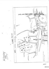 Bendigo Historical Society Inc.
Document - LONG GULLY HISTORY GROUP COLLECTION: THE LONG GULLY GOLF LINKS
... North Hercules and Energetic Mine Site... Les Thomas... tom Austen... Pearl South Mullock Heap... Doc Catford... Clubs Wearne... Pearl Mining Co's diggings... Pearl South... Pearl East... Bill and Faye Osterfield... Ellen Lee Osterfield... Eaglehawk Gold...History House 11 Mackenzie Street Bendigo goldfields BENDIGO History long gully history group The Long Gully History Group - The Long Gully Golf Links A Crossley John Harvey Long Gully Rec Dai Gum San Reservation Quarry Hill Golf Club Bendigo Golf Club Marong Gulf Club Miss Colgan Sacred Heart Cathedral Choir Mechanics Institute Rose of Australia Hotel North Hercules and Energetic Mine Site Les Thomas tom Austen Pearl South Mullock Heap Doc Catford Clubs Wearne Pearl Mining Co's diggings Pearl South Pearl East Bill and Faye Osterfield Ellen Lee Osterfield Eaglehawk Gold Club Neangar Park Golf Club F M Fitzpatrick Kangaroo Flat Golf Club Long Gully Playground Pearl Sands Ennor Brothers Birchmore Brothers Shirley Harvey Belvoir Park Harold Ennor George Ennor Some history of the Long Gully Golf Links, a 9 Hole Course, by John Harvey. ...Some history of the Long Gully Golf Links, a 9 Hole Course, by John Harvey. First page has a map of the area showing where the holes are and different features. There is a description of the tees and the route taken around the course.Dates when the Eaglehawk, Neangar park, Kangaroo Flat Golf Clubs and the Long Gully Playground were opened.bendigo, history, long gully history group, the long gully history group - the long gully golf links, a crossley, john harvey, long gully rec, dai gum san reservation, quarry hill golf club, bendigo golf club, marong gulf club, miss colgan, sacred heart cathedral choir, mechanics institute, rose of australia hotel, north hercules and energetic mine site, les thomas, tom austen, pearl south mullock heap, doc catford, clubs wearne, pearl mining co's diggings, pearl south, pearl east, bill and faye osterfield, ellen lee osterfield, eaglehawk gold club, neangar park golf club, f m fitzpatrick, kangaroo flat golf club, long gully playground, pearl sands, ennor brothers, birchmore brothers, shirley harvey, belvoir park, harold ennor, george ennor -
 Bendigo Historical Society Inc.
Document - MCCOLL, RANKIN AND STANISTREET COLLECTION: NOTES RE GOVERNMENT GAZETTES AND LIST OF PLANT
... Includes Chinese regulations for management of Chinese on Gold fields (1856) , Chinamans Flat Steam Engine company (1857), two Chinese murdered at Clinkers Hill, Castlemaine (1862) Charles Chromley Dowling appointed Chinese Protector (1857), John Chatfield Tyler Immigration agent, to carry out the Chinese Emigrations Act (1861) Back page dated 1947 lists "stocktake list of plant" On list - Deborah United 1946; North Hustlers; New Monument GMC, North Virginia, South Wattle Gully, Central Napoleon, Red, White and Blue Extended, Deborah Extended, New Don, East Clarence, Napoleon Reef, New Monument Battery, Deborah Extended. ...Includes Chinese regulations for management of Chinese on Gold fields (1856) , Chinamans Flat Steam Engine company (1857), two Chinese murdered at Clinkers Hill, Castlemaine (1862) Charles Chromley Dowling appointed Chinese Protector (1857), John Chatfield Tyler Immigration agent, to carry out the Chinese Emigrations Act (1861) Back page dated 1947 lists "stocktake list of plant" On list - Deborah United 1946; North Hustlers; New Monument GMC, North Virginia, South Wattle Gully, Central Napoleon, Red, White and Blue Extended, Deborah Extended, New Don, East Clarence, Napoleon Reef, New Monument Battery, Deborah Extended. ...Two page, handwritten document on lined paper - front page reference to Victorian Government Gazettes and Chinese regulations, where listed in the gazettes and dates. Includes Chinese regulations for management of Chinese on Gold fields (1856) , Chinamans Flat Steam Engine company (1857), two Chinese murdered at Clinkers Hill, Castlemaine (1862) Charles Chromley Dowling appointed Chinese Protector (1857), John Chatfield Tyler Immigration agent, to carry out the Chinese Emigrations Act (1861) Back page dated 1947 lists "stocktake list of plant" On list - Deborah United 1946; North Hustlers; New Monument GMC, North Virginia, South Wattle Gully, Central Napoleon, Red, White and Blue Extended, Deborah Extended, New Don, East Clarence, Napoleon Reef, New Monument Battery, Deborah Extended. Possibly written by Albert Richardson.bendigo, mining, mccoll rankin & stanistreet -
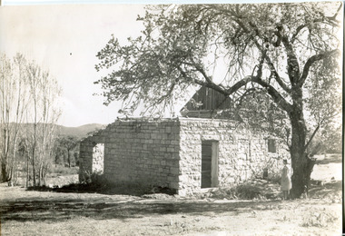 The Beechworth Burke Museum
Photograph, Approximately 1930
... Upon hearing of the vast discovery of gold in Victoria's north-east, he engaged in mining in the Ovens Goldfield district before starting his own dairy on Wooragee road (now Old Wooragee road). ...Upon hearing of the vast discovery of gold in Victoria's north-east, he engaged in mining in the Ovens Goldfield district before starting his own dairy on Wooragee road (now Old Wooragee road). ...Taken in approximately 1930, this photograph depicts the ruins of Rosehill Dairy. A woman stands beside the ruins, observing them solemnly. The owner of this once prominent dairy, John Brewer, was born in Cornwall, England in 1832. After coming to Australia in 1849, Brewer worked in various forms of livestock transportation. Upon hearing of the vast discovery of gold in Victoria's north-east, he engaged in mining in the Ovens Goldfield district before starting his own dairy on Wooragee road (now Old Wooragee road). The Wooragee Valley, approximately five kilometres north of Beechworth, was used extensively during the nineteenth century to build farming practices in the area, possessing eighteen farms by 1860. Brewer enjoyed a prosperous career in the dairy industry, personally delivering milk to the residents of Beechworth. He died on the thirteenth of August 1915, a few weeks shy of his eighty-third birthday. As this photograph is dated approximately fifteen years later, it can be assumed that the dairy fell into neglect following his death. This photograph is historically significant as it provides insight the development of the dairy industry in Beechworth in the second half of the nineteenth century.Black and white square photograph printed on matte photographic paper Reverse: 1997.2912 / John Brewers / Rosehill / Dairy / top of the 'rising sun' /john brewer, 1930 beechworth, rosehill dairy, dairy industry beechworh, dairy factories beechworth, dairying, dairy farm beechworth, wooragee road, wooragee valley, old wooragee road, dairy farm ruins -
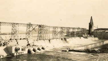 The Beechworth Burke Museum
Photograph
... gold mining town. Mitta Mitta is called Midamodunga by the local Indigenous peoples Wodonga: Wodonga is situated on the Murray River and is part of North East Victoria. ...gold mining town. Mitta Mitta is called Midamodunga by the local Indigenous peoples Wodonga: Wodonga is situated on the Murray River and is part of North East Victoria. ...Taken on 25 October 1930, various houses with the Hume Dam under construction are depicted in the background. The construction of the Hume Dam took place from 1919 to 1936. At the time of construction, it was the second largest dam in the world. It was also one of the earliest civil projects developed after the Federation. Some of the Dam workers consisted of World War I veterans. Dam workers often settled their families in Mitta Junction Village and Wodonga. Archaeological surveys were completed by Austral Archaeology, which was done when the Department of Land & Water Conservation was doing work to improve Hume Dam. The archaeological report that came out of the survey recommended three sites of interest where archaeological excavation should be done: Camp Ganger’s Quarters, Stableman’s Quarters, and the Industrial Dump. The excavation uncovered artefacts. Mitta Mitta: Mitta Mitta is situated between Mount Welcome and Mount Misery. It is named after the river that explorers Hume and Hovell discovered in 1824. The town would eventually become a huge gold mining town. Mitta Mitta is called Midamodunga by the local Indigenous peoples Wodonga: Wodonga is situated on the Murray River and is part of North East Victoria. Hume and Hovell: Hamilton Hume (1979-1873) and William Hilton Hovell (1786-1875). W. H. Hovell was born in Norfolk England and Hume was born in Parramatta, New South Wales Hovell and Hume undertook an exploration journey in 1824 and thought they discovered a river, which turned out to be the Murray River. They returned home in 1825, but returned to the area in 1826 and discovered coal in the area. This photo is historically significant as it shows the Hume Dam under construction in 1930. The Dam was named after Hamilton Hume, who is an important historical figure for this area as he helped discover the area where resources were found.Sepia rectangular photograph printed unmountedReverse: 84-19-5 / 1997.3185/ Values & spillway. / When completed the wall / will be as high as the / scaffolding. [featuring trademark: kodak print]construction, houses, veterans, mitta junction village, hume dam, world war i, federation, wodonga, archaeological survey, excavation, austral archaeology, department of land & water conservation, camp ganger's quarter's, stableman's quarters, industrial dump, artefacts, mitta mitta, mount welcome, mount misery, murray river, hamilton hume, william hilton hovell, hume and hovell expedition -
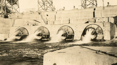 The Beechworth Burke Museum
Photograph, c1930
... gold mining town. Mitta Mitta is called Midamodunga by the local Indigenous peoples Wodonga: Wodonga is situated on the Murray River and is part of North East Victoria. ...gold mining town. Mitta Mitta is called Midamodunga by the local Indigenous peoples Wodonga: Wodonga is situated on the Murray River and is part of North East Victoria. ...Taken on 25 October 1930, various houses with the Hume Dam under construction are depicted in the background. The construction of the Hume Dam took place from 1919 to 1936. At the time of construction, it was the second largest dam in the world. It was also one of the earliest civil projects developed after the Federation. Some of the Dam workers consisted of World War I veterans. Dam workers often settled their families in Mitta Junction Village and Wodonga. Archaeological surveys were completed by Austral Archaeology, which was done when the Department of Land & Water Conservation was doing work to improve Hume Dam. The archaeological report that came out of the survey recommended three sites of interest where archaeological excavation should be done: Camp Ganger’s Quarters, Stableman’s Quarters, and the Industrial Dump. The excavation uncovered artefacts. Mitta Mitta: Mitta Mitta is situated between Mount Welcome and Mount Misery. It is named after the river that explorers Hume and Hovell discovered in 1824. The town would eventually become a huge gold mining town. Mitta Mitta is called Midamodunga by the local Indigenous peoples Wodonga: Wodonga is situated on the Murray River and is part of North East Victoria. Hume and Hovell: Hamilton Hume (1979-1873) and William Hilton Hovell (1786-1875). W. H. Hovell was born in Norfolk England and Hume was born in Parramatta, New South Wales Hovell and Hume undertook an exploration journey in 1824 and thought they discovered a river, which turned out to be the Murray River. They returned home in 1825, but returned to the area in 1826 and discovered coal in the area.This photo is historically significant as it shows the Hume Dam under construction in 1930. The Dam was named after Hamilton Hume, who is an important historical figure for this area as he helped discover the area where resources were found.Sepia rectangular photograph printed unmountedReverse: 84-19-2/ 1997.3188/ These are the four / release valves they are / not always open (illegible) this / when closed the water flows / over the spillway. [featuring trademark: kodak print] photograph number: 354construction, houses, veterans, mitta junction village, hume dam, world war i, federation, wodonga, archaeological survey, excavation, austral archaeology, department of land & water conservation, camp ganger's quarter's, stableman's quarters, industrial dump, artefacts, mitta mitta, mount welcome, mount misery, murray river, hamilton hume, william hilton hovell, hume and hovell expedition -
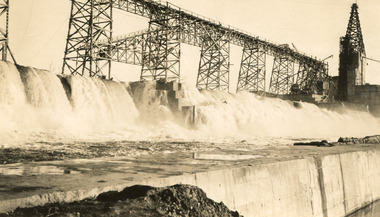 The Beechworth Burke Museum
Photograph, 25 October 1930
... gold mining town. Mitta Mitta is called Midamodunga by the local Indigenous peoples Wodonga: Wodonga is situated on the Murray River and is part of North East Victoria. ...gold mining town. Mitta Mitta is called Midamodunga by the local Indigenous peoples Wodonga: Wodonga is situated on the Murray River and is part of North East Victoria. ...Taken on 25 October 1930, various houses with the Hume Dam under construction are depicted in the background. The construction of the Hume Dam took place from 1919 to 1936. At the time of construction, it was the second largest dam in the world. It was also one of the earliest civil projects developed after the Federation. Some of the Dam workers consisted of World War I veterans. Dam workers often settled their families in Mitta Junction Village and Wodonga. Archaeological surveys were completed by Austral Archaeology, which was done when the Department of Land & Water Conservation was doing work to improve Hume Dam. The archaeological report that came out of the survey recommended three sites of interest where archaeological excavation should be done: Camp Ganger’s Quarters, Stableman’s Quarters, and the Industrial Dump. The excavation uncovered artefacts. Mitta Mitta: Mitta Mitta is situated between Mount Welcome and Mount Misery. It is named after the river that explorers Hume and Hovell discovered in 1824. The town would eventually become a huge gold mining town. Mitta Mitta is called Midamodunga by the local Indigenous peoples Wodonga: Wodonga is situated on the Murray River and is part of North East Victoria. Hume and Hovell: Hamilton Hume (1979-1873) and William Hilton Hovell (1786-1875). W. H. Hovell was born in Norfolk England and Hume was born in Parramatta, New South Wales Hovell and Hume undertook an exploration journey in 1824 and thought they discovered a river, which turned out to be the Murray River. They returned home in 1825, but returned to the area in 1826 and discovered coal in the area.This photo is historically significant as it shows the Hume Dam under construction in 1930. The Dam was named after Hamilton Hume, who is an important historical figure for this area as he helped discover the area where resources were found.Sepia rectangular photograph printed unmountedReverse: 84-19-6/ 1997.3187/ The spillway [featuring trademark: kodak print] construction, houses, veterans, mitta junction village, hume dam, world war i, federation, wodonga, archaeological survey, excavation, austral archaeology, department of land & water conservation, camp ganger's quarter's, stableman's quarters, industrial dump, artefacts, mitta mitta, mount welcome, mount misery, murray river, hamilton hume, william hilton hovell, hume and hovell expedition