Showing 55 items matching "north east railway victoria"
-
 Wodonga & District Historical Society Inc
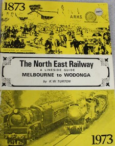
Book - The NORTH EAST RAILWAY Melbourne to Wodonga- A Lineside Guide, Keith W. Turton, 1973
... railway transport victoria...north east...Wodonga & District Historical Society Inc Hut 97, Bonegilla Migrant Experience, 132 Bonegilla Road Bonegilla the-murray railway transport victoria north east railway victoria victoria railways lineside rail guide A detailed history and description of the North East Rail Line, including information about each station and siding and relevant maps. ...A detailed history and description of the North East Rail Line, including information about each station and siding and relevant maps.non-fictionA detailed history and description of the North East Rail Line, including information about each station and siding and relevant maps.railway transport victoria, north east railway victoria, victoria railways, lineside rail guide -
 Federation University Historical Collection
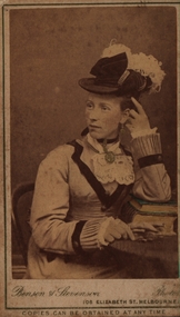
Photograph - Sepia photograph, Benson & Stevenson, Emma Eliza Jane Phillips, c1860's
... Victoria, Australia 27/04/1920, age 81. He came to Australia seeking gold but instead of finding a fortune he worked for the Victorian Railways. After living in Sebastapol and Ballarat North they settled on a small farm at Yendon named "Gracedale" They were married in Ballarat at Saint Paul's Church of England in Ballarat East. ...Victoria, Australia 27/04/1920, age 81. He came to Australia seeking gold but instead of finding a fortune he worked for the Victorian Railways. After living in Sebastapol and Ballarat North they settled on a small farm at Yendon named "Gracedale" They were married in Ballarat at Saint Paul's Church of England in Ballarat East. ...Emma was one of the first white children born in the Barrabool Hills (Geelong) to parents Richard and Elizabeth Phillips. Emma Eliza Jane Phillips was one of the first white children born in the Barrabool Hills (South Geelong) in the Port of New South Wales on 25/04/1844 and died at "Gracedale" Yendon 12/10/1925, age 81. Emma was the daughter of Richard Price Phillips and Elizabeth Anne Goodenough. Richard, originally a coach plater, was the licensee of "The Thistle Inn", a small hotel on the corner of Corio and Yarra Streets. Elizabeth appears to have had a dressmakers shop around the corner in Yarra Street. Emma married Thomas Watson in Ballarat in 18--? Thomas William Watson was born in Harston, Cambridge, England on10/11/1838 and died at "Gracedale", Yendon, Victoria, Australia 27/04/1920, age 81. He came to Australia seeking gold but instead of finding a fortune he worked for the Victorian Railways. After living in Sebastapol and Ballarat North they settled on a small farm at Yendon named "Gracedale" They were married in Ballarat at Saint Paul's Church of England in Ballarat East. Emma sang in the choir and was a member of the Ballarat Philharmonic Society. They first lived in Sebastapol, then Crompton Street, Ballarat North before building a house at Yendon. Thomas and Emma had 10 children, five boys and five girls, also rearing 3 grandchildren. Thomas and some of his sons ( including John Richard) helped to cut the original steps at Lal Lal to the bottom of the Lal Lal Falls.Photograph of a woman seated at a table with one elbow resting on books. Her jewllery has been hand painted in gold and the top book cover in green. C1860Front: Benson & Stevenson 108 Elizabeth Street Melbourne Copies can be obtained at any time Verso: Emma Eliza Jane (Phillips) Watson; 1844-1925; 81yrs; Died "Gracedale" Yendon, Vic; Born - South Geelong/Barrabool Hills; Dad's (John Richard Watson) motheremma eliza jane phillips, emma eliza jane watson, barrabool hills, yendon, thomas watson, richard price phillips, elizabeth goodenough, lal lal falls -
 Glen Eira Historical Society
Document - Historic Conservation Areas Project
... Ford Hazel Preliminary Conservation Survey Town Planning Heritage Studies Rodda Andrew City of Caulfield Housing Estates Victoria National Estate Grants Program Australia Icomos Burra Charter Buildings Structures and Establishments Land Surveys Suburbs Historic Buildings Architectural Significance ‘Caulfield’s Heritage Study’ Soloman Geulah Dr. Caulfield Library Dandenong Road Nepean Highway Hotham Street Iknerman Road Orrong Road North Road Poath Road ‘Plan of the City of Caulfield’ North Ward East Ward South Ward West Ward Kooyong Road Neerim Road Bambra Road Balaclava Road Shire of Caulfield Railways World War 1914-1918 Depression 1929-1939 Rippon Lea Labassa Parks Mansions Community Services ‘Caulfield North Draft Heritage Guidelines July 1999’ City of Glen Eira Caulfield North Heritage Area Glen Eira Heritage Management Plan Mayfield Grove Normanby Avenue Carnarvon Street Glenferrie Street Arthur Street Malakoff Street Normanby Road Heritage Advisory Service Construction Materials Victorian Style Mediterranean Style Spanish Mission Style Californian Bungalow Style Federation Style Architectural Style Architectural Features Heritage Conservation Design Building Construction Building Regulations Aboriginal Peoples Carnarvon Road Document Historic Conservation Areas Project ...Contains 4 items relating to historic conservation: 1/Five newsletters (one page each newsletter, dated 07/1975, 08/1975, 09/1975, 10/1975 and the final one 12/1975) describing how the project evolved, project funds, progress, study method, project 1 report, project 2 report and summary as no further funds available. Project was to include all of Melbourne but funding did not allow this. Note: newsletters stamped with Caulfield Historical Society. 2/Letter (one page on official city of Caulfield letterhead) from Andrew Rodda (manager planning) to Hazal Ford (dated 13/11/1989) describing ‘council resolved on 18/07/1989 to proceed with preliminary conservation survey’ and mentions that a copy is included. 3/Preliminary conservation survey for the City of Caulfield (nine pages) describing background, study area, budget, purpose, study outline, timeframe, report format, ownership, tasks and background information (mentions number and types of houses and properties as at 1986 and 1988) and a map of City of Caulfield. 4/Booklet (28 pages) titled ‘Heritage Area – Caulfield North Draft Heritage Guidelines July 1999 – City of Glen Eira’, containing Caulfield North Heritage Area, cultural heritage, Heritage Overlay Area, architectural description, common architectural forms and features, development guidelines, key design checklist. It includes a map of the Caulfield North Heritage Overlay Area, two illustrations about the development envelope and many black-and-white photographs of houses and architectural features.historic conservation areas project niven barbara, newsletters, town planning, historic buildings, heritage studies, housing, royal historical society of victoria (rhsv), read michael, plans, local government, historical societies, committee for urban action (cua), national trust, hopkins sherry ms., ford hazel, preliminary conservation survey, town planning, heritage studies, rodda andrew, city of caulfield, housing estates, victoria national estate grants program, australia icomos, burra charter, buildings structures and establishments, land surveys, suburbs, historic buildings, architectural significance, ‘caulfield’s heritage study’, soloman geulah dr., caulfield library, dandenong road, nepean highway, hotham street, iknerman road, orrong road, north road, poath road, ‘plan of the city of caulfield’, north ward, east ward, south ward, west ward, kooyong road, neerim road, bambra road, balaclava road, shire of caulfield, railways, world war 1914-1918, depression 1929-1939, rippon lea, labassa, parks, mansions, community services, ‘caulfield north draft heritage guidelines july 1999’, city of glen eira, caulfield north heritage area, glen eira heritage management plan, mayfield grove, normanby avenue, carnarvon street, glenferrie street, arthur street, malakoff street, normanby road, heritage advisory service, construction materials, victorian style, mediterranean style, spanish mission style, californian bungalow style, federation style, architectural style, architectural features, heritage conservation design, building construction, building regulations, aboriginal peoples, carnarvon road -
 Bendigo Historical Society Inc.
Document - LONG GULLY HISTORY GROUP COLLECTION: THE BENDIGO GOLDFIELD … INTRODUCTION TO FIELD
... Railway Mine... The Dascombe Nugget... The Victoria Nugget... R R Haverfield... Ballerstadt... Rae... Wittscheibe... Lazarus... Cave and Amos... Geo Lansell... The Old Chum... Victoria... Specimen... Hustlers... Bendigo Amalgamated Goldfields... Bendigo Mines Limited... Nell Gwynne... Napoleon... Carshalton... The Deborah... Roberts & Sons... The North Deborah... Williams' United... Central Deborah... Lansell's South Red White & Blue... The New Red White and Blue Consolidated (Big Blue)... Union... H Harkness & Co... Thompson & Co... Lansell's Bendigo Battery... Showgrounds Industrial Hall... North Red White and Blue... Central Red White and Blue... Little 180... John Brown Knitwear Factory... South Ironbark... Victoria Consols East...History House 11 Mackenzie Street Bendigo goldfields BENDIGO History long gully history group The Long Gully History Group - The Bendigo Goldfield...Introduction to Field A Richardson New Chum Railway Mine The Dascombe Nugget The Victoria Nugget R R Haverfield Ballerstadt Rae Wittscheibe Lazarus Cave and Amos Geo Lansell The Old Chum Victoria Specimen Hustlers Bendigo Amalgamated Goldfields Bendigo Mines Limited Nell Gwynne Napoleon Carshalton The Deborah Roberts & Sons The North Deborah Williams' United Central Deborah Lansell's South Red White & Blue The New Red White and Blue Consolidated (Big Blue) Union H Harkness & Co Thompson & Co Lansell's Bendigo Battery Showgrounds Industrial Hall North Red White and Blue Central Red White and Blue Little 180 John Brown Knitwear Factory South Ironbark Victoria Consols East Shaft Ironbark Manchester Arms Hotel Unity Mine Wattle Gully Mine Chewton Hercules Hercules and Energetic Bendigo Amalgamated Goldfields Coy Long Gully Post Office The Old Wheal Owl Central Nell Gwynne Gold Mines Hotel Bendigo City Council Mr Jack Barker Bendigo and District Tourist Association The New Chum Syncline Courier of the Mines newspaper Camp Hill School Sandhurst East Post Office Bendigo Cemetery White Hills Cemetery Eaglehawk Cemetery Kangaroo Flat Cemetery Albert Richardson The Bendigo Goldfield ...Introduction to Field. ...The Bendigo Goldfield ...Introduction to Field. Compiled by A. Richardson. Mentioned are the Deborah Line of Reef, The Sheepshead Line, The Nell Gwynne Line and The Carshalton Line of Reef. Mines mentioned are: The Deborah, The North Deborah, Central Deborah, The New Red White and Blue Consolidated (Big Blue), North Red White and Blue, Central Red white and Blue, Little 180, South Ironbark, Ironbark, Hercules, Central Nell Gwynne and The New Chum Syncline. Lansell's Bendigo Battery is also mentioned. There is a short description of each mine, depth. location, machinery, Gold yield, Dividends and Calls. Closing date of some (some closed as a result of fire). Also mentioned is the postal service and the establishment of cemeteries at Bendigo, White Hills, Eaglehawk and Kangaroo Flat.Albert Richardsonbendigo, history, long gully history group, the long gully history group - the bendigo goldfield...introduction to field, a richardson, new chum railway mine, the dascombe nugget, the victoria nugget, r r haverfield, ballerstadt, rae, wittscheibe, lazarus, cave and amos, geo lansell, the old chum, victoria, specimen, hustlers, bendigo amalgamated goldfields, bendigo mines limited, nell gwynne, napoleon, carshalton, the deborah, roberts & sons, the north deborah, williams' united, central deborah, lansell's south red white & blue, the new red white and blue consolidated (big blue), union, h harkness & co, thompson & co, lansell's bendigo battery, showgrounds industrial hall, north red white and blue, central red white and blue, little 180, john brown knitwear factory, south ironbark, victoria consols east shaft, ironbark, manchester arms hotel, unity mine, wattle gully mine chewton, hercules, hercules and energetic, bendigo amalgamated goldfields coy, long gully post office, the old wheal owl, central nell gwynne, gold mines hotel, bendigo city council, mr jack barker, bendigo and district tourist association, the new chum syncline, courier of the mines newspaper, camp hill school, sandhurst east post office, bendigo cemetery, white hills cemetery, eaglehawk cemetery, kangaroo flat cemetery -
 The Beechworth Burke Museum
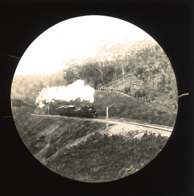
Photograph - Lantern Slide, c1900
... north-east victoria...rail trail...beechworth rail trail...beechworth station...everton...wangaratta...wodonga...albury...rail transport...cargo transport...g.b. kerferd...john orr...murray to mountains rail trail...cycling...biking...railway...Burke Museum Beechworth Lantern Slide Slide Glass Slide Plate Burke Museum Collection Photograph Monochrome indigo shire north-east victoria rail trail beechworth rail trail beechworth station everton wangaratta wodonga albury rail transport cargo transport g.b. kerferd john orr murray to mountains rail trail cycling biking railway Thin translucent sheet of glass with a circular image printed on the front and framed in a black backing. ...This slide shows a train proceeding along the Beechworth rail trail in approximately 1900. The rail line to Beechworth was the subject of significant lobbying by local officials such as John Orr and G.B. Kerferd in the 1860s, as it was recognised that the poor quality of roads to Melbourne and Albury hindered trade and formed a barrier to the social development of the town. The subsequent positioning of Beechworth on a branch rather than a main line was not considered ideal to achieve these aims, but the Everton-to-Beechworth and Beechworth-to-Yackandandah components of the line cost an average of £7,277 per mile and State Government officials felt the need in the area did not justify the cost of a direct line. The Beechworth Railway Station was officially opened on the 29th of September 1876 and ran services twice daily to Melbourne, transporting nearly 12,000 passengers and around 6,500 tons of cargo in 1900. It closed in 1976 and is today used as a cycling trail used by locals and promoted as a feature of the area to tourists. Lantern slides, sometimes called 'magic lantern' slides, are glass plates on which an image has been secured for the purpose of projection. Glass slides were etched or hand-painted for this purpose from the Eighteenth Century but the process became more popular and accessible to the public with the development of photographic-emulsion slides used with a 'Magic Lantern' device in the mid-Nineteenth Century. Photographic lantern slides comprise a double-negative emulsion layer (forming a positive image) between thin glass plates that are bound together. A number of processes existed to form and bind the emulsion layer to the base plate, including the albumen, wet plate collodion, gelatine dry plate and Woodburytype techniques. Lantern slides and magic lantern technologies are seen as foundational precursors to the development of modern photography and film-making techniques.This glass slide is significant because it provides insight into Beechworth's social amenities and transport infrastructure in the late Nineteenth Century. It is also an example of an early photographic and film-making technology in use in regional Victoria in the time period.Thin translucent sheet of glass with a circular image printed on the front and framed in a black backing. It is held together by metal strips to secure the edges of the slide.burke museum, beechworth, lantern slide, slide, glass slide, plate, burke museum collection, photograph, monochrome, indigo shire, north-east victoria, rail trail, beechworth rail trail, beechworth station, everton, wangaratta, wodonga, albury, rail transport, cargo transport, g.b. kerferd, john orr, murray to mountains rail trail, cycling, biking, railway -
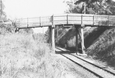 Ringwood and District Historical Society
Photograph, Eastfield Road Railway Bridge, Ringwood East, Victoria
... Ringwood and District Historical Society 125A Warrandyte Road Ringwood North melbourne Eastfield Road railway bridge looking east- 1 photograph taken on 1/09/74 and 2 photos taken on 5/10/74 Black and white photographs : 3 images Eastfield Road Railway Bridge, Ringwood East, Victoria Photograph ...Black and white photographs : 3 imagesEastfield Road railway bridge looking east- 1 photograph taken on 1/09/74 and 2 photos taken on 5/10/74 -
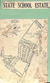 Ringwood and District Historical Society
Map, Plan of Subdivision - State School Estate, Ringwood East, Victoria - (Undated, circa 1920s)
... North melbourne Locality plan includes reference to proposed Ringwood East railway station which opened in 1925. Map of land for sale attached to green cardboard backing with handwritten notations showing numbered allotments on Dublin Road, Holland Road, King Street, Charles Street and Purser Avenue, Ringwood East. Plan of Subdivision - State School Estate, Ringwood East, Victoria ...Map of land for sale attached to green cardboard backing with handwritten notations showing numbered allotments on Dublin Road, Holland Road, King Street, Charles Street and Purser Avenue, Ringwood East.Locality plan includes reference to proposed Ringwood East railway station which opened in 1925. -
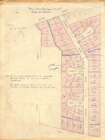 Ringwood and District Historical Society
Map - Plan of Subdivision, Part of Crown Allotment 27 & 27B, Parish of Ringwood - (Undated, circa late 1950s)
... North melbourne Note: Lot 15 is to be transferred to the Ringwood Borough Council for use as a children's playground. Map includes handwritten sales notations for several allotments, e.g. Sold. Copy of land title map in manilla folder showing layout and size of 60 allotments in Railway Avenue, Victoria Street, Smithdene Avenue, Richard Court, Jeanette Court, Bruce Court and Loma Street, Ringwood East, Victoria. ...Copy of land title map in manilla folder showing layout and size of 60 allotments in Railway Avenue, Victoria Street, Smithdene Avenue, Richard Court, Jeanette Court, Bruce Court and Loma Street, Ringwood East, Victoria.Note: Lot 15 is to be transferred to the Ringwood Borough Council for use as a children's playground. Map includes handwritten sales notations for several allotments, e.g. Sold. -
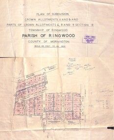 Ringwood and District Historical Society
Map - Plan of Subdivision, Crown Allotments 4 and 5, and Parts of Crown Allotments 6, 8 and 9 Section B, Township and Parish of Ringwood, County of Mornington - Salter's Estate East Ringwood Victoria - 1956
... Ringwood and District Historical Society 125A Warrandyte Road Ringwood North melbourne Subdivision includes Railway Avenue, Nicholson Street, Althol Grove (later Morcom Avenue), Illoura Avenue, Tweed Street, Merry Street, and Dublin Road, Ringwood East, Victoria. ...Land Title map of 51 allotments with property dimensions and handwritten real estate sales notations. Copy of map on cardboard backing - extracted from auction advertisement for Saturday, 10th November (1956).Subdivision includes Railway Avenue, Nicholson Street, Althol Grove (later Morcom Avenue), Illoura Avenue, Tweed Street, Merry Street, and Dublin Road, Ringwood East, Victoria. -
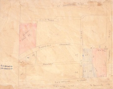 Ringwood and District Historical Society
Drawing - Hand-drawn map, Part of Crown Allotment 22, Ringwood East, Victoria (Undated)
... Ringwood and District Historical Society 125A Warrandyte Road Ringwood North melbourne (Railway line to Healesville marked on the map indicates creation date precedes closure of line beyond Lilydale in 1980) Pencil drawing on light cardboard backing. Colour-shaded residential allotments on Rosedale Crescent, Patterson Street and Federal Road, Ringwood East. Part of Crown Allotment 22, Ringwood East, Victoria ...Pencil drawing on light cardboard backing. Colour-shaded residential allotments on Rosedale Crescent, Patterson Street and Federal Road, Ringwood East.(Railway line to Healesville marked on the map indicates creation date precedes closure of line beyond Lilydale in 1980) -
 Ringwood and District Historical Society
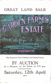
Pamphlet, G.A. Green, Auction Sale Brochure - Garden Farms Estate, Ringwood, Victoria - 1919, 1919
... Railway. Its natural boundaries are the River Yarra on the North, Dandenong Creek on the South, the popular town of Croydon on the East, and the suburb of Mitcham on the West. This is a large territory that is steadily being converted from intense culture, and then it might be called (as regards its gardens) "The Devon Territory of Victoria." ...Railway. Its natural boundaries are the River Yarra on the North, Dandenong Creek on the South, the popular town of Croydon on the East, and the suburb of Mitcham on the West. This is a large territory that is steadily being converted from intense culture, and then it might be called (as regards its gardens) "The Devon Territory of Victoria." ...Multi-fold brochure advertising public auction of one-acre, 2-acre, 5-acre and 8-acre allotments in Ringwood and Bayswater on Saturday 12th April, 1919. Brochure includes terms of sale, description of subdivision features and local facilities, and photographic images of the area.Subdivison includes Canterbury Road Heathmont, Armstrong Road Heathmont, Armstrong Road Bayswater, Bungalook Road Heathmont, Bungalook Road Bayswater, and Orchard Road Bayswater. Road shown as Bayswater Road to Bayswater became Mountain Highway Bayswater. Vendor: H.E.B.Armstrong, Auctioneers: Coghill & Haughton, 79 Swanston Street Melbourne, Telephone Central 2793, in conjunction with J.B. McAlpin, Ringwood, Opposite Station, Telephone Ringwood 7. (Map) Woodcock & McCormack, Civil Engineers Architects & Surveyors, 430 Little Collins Street, Melbourne, Phone 3241 Central. MOST OF THE MONEY COMES OUT OF THE LAND. And more money can be obtained from anb acre of fruit than from an acre of any other produce. But you do not have to grow fruit on Garden Farms Estate. You can go in for - Outer Suburban Home - Market Garden - Orchard - Pig Raising - Poultry Farm - Small Dairy Farm - Small Fruits - Floral Culture - Scent and Bee Farm - Or just for a Week-end Home. RINGWOOD - THE PLACE TO LIVE. The Beautiful Ringwood District has so many natural attractions, that half a Land Agent's work is done in just showing a prospective buyer round and about. Ringwood has a pull of its own that attracts folk, proved beyond doubt by its rapid development within the last decade (spite the war). First, it is high and healthy, picturesque and undulating, convenient of access, sufficiently close to the Metropolis for City and Business folk to live at Ringwood. Its development is solid, because most of its people are industrious husbandmen, real producers, who have turned idle hills into smiling gardens. These are the kind of real people to live amongst; ones who wear out their spades. The rapidly-developing town has excellent Stores, Trade and Repair Shops Churches, Banks, Telephone Exchange, Weekly General Market, Cool Stores, and good Private and State Schools, etc.; is Electrically lit, has Metropolitan Water Supply, and generally provides so that practically all shopping can be done locally. WHY RINGWOOD MUST GROW. Ringwood is a great centre and must be a greater. Two rapidly-developing railways junction here. The passengers from Ringwood Station cityward, in one year, number 250,000. Ringwood will be the terminus of the Outer Suburban Electric Eastern Railway. Its natural boundaries are the River Yarra on the North, Dandenong Creek on the South, the popular town of Croydon on the East, and the suburb of Mitcham on the West. This is a large territory that is steadily being converted from intense culture, and then it might be called (as regards its gardens) "The Devon Territory of Victoria." ARMSTRONG ROAD. This new road traverses Garden Farms Estate from its northern boundary on the main Canterbury Road, across Dandenong Creek, to its southern boundary on the main Bayswater Road, and will provide a long-desired additional link of communication between Bayswater and Ringwood. The 1-acre building sites on Bayswater Road are within 8 minutes' walk of the Bayswater Railway Station, and the Canterbury Road frontages are only 1-1/2 miles from Ringwood Station, and 1/2 mile from the Railway Station site of Canterbury Road; therefore, the whole Estate is easy of access and there should be a large demand for land so favourably placed. (Image) Cultivation Field - Potatoes on Lot 28 (Image) Picture of Bayswater Creek Flats. (Image) View from "Korumbeen" where Mr. Armstrong lived on Garden Farms Estate. Estate outlined in white ring. (Image) Site of New Bridge over Dandenong Creek. (Image) On one of the timbered lots adjoining railway. (Image) This Dandenong Creek traveres the Estate. (Image) Main Fern Tree Gully Line bisects the Estate. -
Glenelg Shire Council Cultural Collection
Photograph - Contact Print - Scenes of Portland, Victoria, 1970s
... Glenelg Shire Council Cultural Collection History House Cliff Street Portland great-ocean-road Portland scene street scene photography Portland Harbour Portland seafront Julia Street Front: (c) Bentinck Street approx. 1900 (d) Julia Street, portland Nicholls (h) Portland Post Office Sheet of 12 contact prints of rephotographed photographs: (a) 5 young women on dam wall (b) sailors (c) Bentinck Street, looking north from Post Office (d) Julia Street looking east from Percy Street (e) Railway line and Duttons (Nuns) Beach towards Whalers Bluff (f) Fawthrop Lagoon (g) sailors (h) Post Office (i) River, bush close to banks both sides (j) Botanic Gardens (k) Town and Port of Portland reproduced from III London News (l) North side, Julia Street looking west, Bank Australasia Photograph Contact Print - Scenes of Portland, Victoria ...Sheet of 12 contact prints of rephotographed photographs: (a) 5 young women on dam wall (b) sailors (c) Bentinck Street, looking north from Post Office (d) Julia Street looking east from Percy Street (e) Railway line and Duttons (Nuns) Beach towards Whalers Bluff (f) Fawthrop Lagoon (g) sailors (h) Post Office (i) River, bush close to banks both sides (j) Botanic Gardens (k) Town and Port of Portland reproduced from III London News (l) North side, Julia Street looking west, Bank AustralasiaFront: (c) Bentinck Street approx. 1900 (d) Julia Street, portland Nicholls (h) Portland Post Officeportland scene, street scene, photography, portland harbour, portland seafront, julia street -
 Ringwood and District Historical Society
Photograph-B&W, Joan Walker, East Ringwood 2000-Railway Avenue looking East to the junction of Victoria Street, 2000
... Ringwood and District Historical Society 125A Warrandyte Road Ringwood North melbourne East Ringwood 2000-Railway Avenue looking East to the junction of Victoria Street- B&W Photo from Album 6501 East Ringwood 2000-Railway Avenue looking East to the junction of Victoria Street Photograph-B&W Joan Walker ...East Ringwood 2000-Railway Avenue looking East to the junction of Victoria Street- B&W Photo from Album 6501 -
 Ringwood and District Historical Society
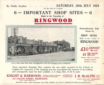
Flyer, Shop Sites Sale By Public Auction, Ringwood, Victoria - 1924
... North melbourne Locality plan highlights shop sites for auction east of Pratt Street along Whitehorse Road. (Agents) Knight & Harwood, 315 Collins Street, Melbourne, Phones 10615, 10616 Central, in conjunction with J.B. McAlpin, Estate Agent, Opposite Railway Station, Ringwood, Phone Ringwood 7. Folded double-sided brochure advertising six Ringwood shop sites for sale by Public Auction at 3pm, Saturday, July, 1924, with town photographs, location map, and summary of local features and services. Includes newspaper extract from the Real Estate and Property section from "Evening Sun", 6th June, 1924. Shop Sites Sale By Public Auction, Ringwood, Victoria ...Folded double-sided brochure advertising six Ringwood shop sites for sale by Public Auction at 3pm, Saturday, July, 1924, with town photographs, location map, and summary of local features and services. Includes newspaper extract from the Real Estate and Property section from "Evening Sun", 6th June, 1924.Locality plan highlights shop sites for auction east of Pratt Street along Whitehorse Road. (Agents) Knight & Harwood, 315 Collins Street, Melbourne, Phones 10615, 10616 Central, in conjunction with J.B. McAlpin, Estate Agent, Opposite Railway Station, Ringwood, Phone Ringwood 7. -
 Ballarat Tramway Museum
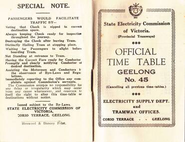
Photograph - Digital image, State Electricity Commission of Victoria (SECV), "Official Timetable Geelong No. 45"
... East Geelong (3), Eastern Park (4), Newtown (5), North (6), West Geelong (7). Gives details of railway station trams, transfer ticket arrangements, depot workings and the night signs carried out each tram. Based on the 4d max fare, it is a circa 1949 timetable - see reference. See also Reg Item 5629 for Timetable No. 39, c1943 and 8552 for a photocopy of No. 47, March 1953 and 9821 for a photocopy of No. 46. See BTM document, "SEC fare changes - by law references etc.doc, dated 3/9/2006. "Official Timetable Geelong No. 45" Photograph Digital image State Electricity Commission of Victoria ...Digital image or copy of the SEC "Official Timetable Geelong No. 45", 16 image files - 32 pages, giving details of the fares, transfers, luggage or parcels, lost property, times of each tram on the Belmont (1), Chilwell (2), East Geelong (3), Eastern Park (4), Newtown (5), North (6), West Geelong (7). Gives details of railway station trams, transfer ticket arrangements, depot workings and the night signs carried out each tram. Based on the 4d max fare, it is a circa 1949 timetable - see reference. See also Reg Item 5629 for Timetable No. 39, c1943 and 8552 for a photocopy of No. 47, March 1953 and 9821 for a photocopy of No. 46. See BTM document, "SEC fare changes - by law references etc.doc, dated 3/9/2006.trams, tramways, geelong, timetables -
 Ballarat Tramway Museum
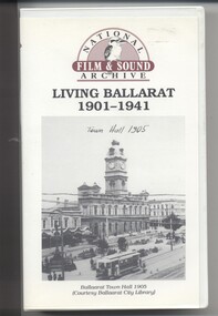
Film - Video cassette tape and box, Chris Long, "Living Ballarat 1901 - 1941", 1990
... in Sturt St 57.45 - colour segment of the festival, 58.39 - Grenville St tram shelter, Bridge St, Sturt St, arches, Main Road, Council Road Roller, Victoria St, Eureka Stockade Reserve, Botanic Gardens, setting up the flowers, wax papers. 1.01.48 - decorated tram, north side of Sturt St, details of the materials used, Crockers. 1.03.20 - Hospital Fund Raising Gala Day - March 1938, special trains arriving Ballarat Railway Station, fund raising procession, pageant at the Showgrounds, fly past. 1.07.35 - 1939 Summer, motor cycle races at Learmonth, City Oval fire brigade demonstrations, Ballarat (East) Fire Station decorated for the 1939 Floral Festival with tram in the background and No. 29, Floral Tram and others. 1.09.25 - July 1914 - Ballarat at War parade, troops. 1.10.10 - credits. ...in Sturt St 57.45 - colour segment of the festival, 58.39 - Grenville St tram shelter, Bridge St, Sturt St, arches, Main Road, Council Road Roller, Victoria St, Eureka Stockade Reserve, Botanic Gardens, setting up the flowers, wax papers. 1.01.48 - decorated tram, north side of Sturt St, details of the materials used, Crockers. 1.03.20 - Hospital Fund Raising Gala Day - March 1938, special trains arriving Ballarat Railway Station, fund raising procession, pageant at the Showgrounds, fly past. 1.07.35 - 1939 Summer, motor cycle races at Learmonth, City Oval fire brigade demonstrations, Ballarat (East) Fire Station decorated for the 1939 Floral Festival with tram in the background and No. 29, Floral Tram and others. 1.09.25 - July 1914 - Ballarat at War parade, troops. 1.10.10 - credits. ...Yields information through movie films of the 1960's of Ballarat trams operating in the streets of Ballarat and has a strong association with the maker - National Film and Sound Archives and Chris Long.Video cassette in a plastic case, titled "Living Ballarat - 1901 - 1941, National Film and Sound Archive (1990)". Copyright provisions - National Film and Sound Archive - segments may not be used without their permission, viewing only. Synopsis: based on time - 0.00 - intro, 1901 film, Melbourne, first film in Ballarat, Royal visit to Ballarat, Boer War Monument, first feature length film in Ballarat. 2.50 - Bridge St and Sturt St scenes, filmed from a flat truck pushed by an electric tram, including No. 11 going to City Oval to Lydiard St. 5.00 - Sturt St Military parade, with trams in background and tram running alongside. 6.54 - scene of Alfred Hall and films. 7.32 - scene on Lake Wendouree and paddle steamer - Living Ballarat film - Pathe's Ballarat Gazette local film unit, football ground scene. a children's beauty competition, tree planting at Macarthur St state school, 1911 Ballarat Show, unveiling of the Boer War statue name plates, Lake Wendouree 1912. 13.22 - St Patricks David Pde with trams in the background. 14.24 - Ballarat Kennel club dog show. 15.50 - Royal visit in 1920, Arch of victory opening 17.48 - Day at Macarthur St state school and tree plantation 20.55 - Bakery Hill - Stones Corner with tram tracks, cars, little trams, Sturt St with a tram leaving Grenville St, ESCo 9 turning from Lydiard St to run down to Grenville St. 22.15 - Ballarat Show, Coliseum Hall, 1925, races, machinery shows, boxing troupe. 25.20 - Botanic Gardens Gates, Lake Wendouree area. 25.30 - Gem Picture travelling show - film 26.16 - Formal visit of English pressman to Ballarat, 1925, Botanic Gardens, Eureka Stockade, Avenue of Honor, Moorabool Reservoir. 29.15 - 1927 Fed Govt doco of Ballarat, Black Hill, 1927 Home to Ballarat Festival, Ballarat Commemorative song, Craigs Hotel, Ballarat Post Office, tram centre poles in Lydiard St, tram climbing Sturt St, Town Hall, tram at Lydiard St terminus coursing, 8, Sturt St, view of ESCo Sebastopol car leaving Grenville St, Selkirks Brickworks, the Welcome nugget, Peter Lalor statue, Eureka stockade, sewerage plant, modern housing, Sturt St west, water supply - golf club, the High School, the orphanage, fine homesteads around Ballarat, Lake Wendouree. 41.00 Opening of the Ballarat Aerodrome. 43.11 - Depression work and leading into radio broadcasting - 3BA open 1930, typewriters, radio transmission equipment, radio aerials, boys listening to crystal sets 47.50 - Bluebirds Children session tour to the Gardens, mentions the BTPS, trams 13, 3? and 14 carrying visitors arriving and getting off and picnic. 48.50 - expansion of 3BA transmitter capacity 51.30 - 1934 visit of the Duke of Gloucester - visit to the Lucas factory, views of the work floor and the factory history and then South St band competition at the Showgrounds. 55.10 - South St Music Festivals, Coliseum and fire. 56.25 - Ballarat Floral Festival March 1938 - Victorian Railways arch of welcome. 57.25 - segment in the shot of 12 and 19? in Sturt St 57.45 - colour segment of the festival, 58.39 - Grenville St tram shelter, Bridge St, Sturt St, arches, Main Road, Council Road Roller, Victoria St, Eureka Stockade Reserve, Botanic Gardens, setting up the flowers, wax papers. 1.01.48 - decorated tram, north side of Sturt St, details of the materials used, Crockers. 1.03.20 - Hospital Fund Raising Gala Day - March 1938, special trains arriving Ballarat Railway Station, fund raising procession, pageant at the Showgrounds, fly past. 1.07.35 - 1939 Summer, motor cycle races at Learmonth, City Oval fire brigade demonstrations, Ballarat (East) Fire Station decorated for the 1939 Floral Festival with tram in the background and No. 29, Floral Tram and others. 1.09.25 - July 1914 - Ballarat at War parade, troops. 1.10.10 - credits. Box has images of a tram and town hall on the front and details of the contents on the rear and who made it etc. See images for details. ballarat, 3ba, floral tram, royal visit, buildings, esco -
 Ballarat Tramway Museum
Photograph - Colour Photograph/s - set of 25, Austin Brehaut, 7/04/2000 12:00:00 AM
... North .3 - St John of God Hospital, cnr Mair and Drummond St. Nth. .4 - Hospital Corner, looking South East from Base Hospital .5 - Gardens at Loop (Wendouree Parade) .6 - Gardens Loop and Shelter .7 - Shelter at Gardens Loop .8 - Bridge Mall looking west .9 - Lower Victoria St. along Bridge St .10 - Railway crossing, Ballarat Station, with gates open .11 - Victoria St. hill facing west .12 - Railway crossing, Lydiard St. ...North .3 - St John of God Hospital, cnr Mair and Drummond St. Nth. .4 - Hospital Corner, looking South East from Base Hospital .5 - Gardens at Loop (Wendouree Parade) .6 - Gardens Loop and Shelter .7 - Shelter at Gardens Loop .8 - Bridge Mall looking west .9 - Lower Victoria St. along Bridge St .10 - Railway crossing, Ballarat Station, with gates open .11 - Victoria St. hill facing west .12 - Railway crossing, Lydiard St. ...Yields information about various locations in Ballarat in March 2000 for comparison with previous photographs.Set of 25 colour photographs taken by Austin Brehaut on 7 April 2000 showing various locations that Ballarat trams once ran in, for use in a BTM presentation, named "Ballarat Past and Present" at the COTMA 2000 Ballarat Conference. All on Fujicolour Crystal Archive Paper. On rear in blue ink is the date, location and where relevant a reference number to photo locations that the author of the presentation had requested. Letter from Austin, filed with the worksheet for Reg. Item 1772. 1773.1 - Base Hospital, Cnr Drummond St. North and Mair St. .2 - Hospital Corner - Base Hospital Along Drummond St. North .3 - St John of God Hospital, cnr Mair and Drummond St. Nth. .4 - Hospital Corner, looking South East from Base Hospital .5 - Gardens at Loop (Wendouree Parade) .6 - Gardens Loop and Shelter .7 - Shelter at Gardens Loop .8 - Bridge Mall looking west .9 - Lower Victoria St. along Bridge St .10 - Railway crossing, Ballarat Station, with gates open .11 - Victoria St. hill facing west .12 - Railway crossing, Lydiard St. North .13 - Railway crossing, Ballarat Station, with gates closed .14 - Lydiard St. North terminus from cemetery .15 - Lydiard St. North at Macarthur St. .16 - Lydiard St. North at Sturt St facing South East - Post Office on left .17 - Looking north along Lydiard St at Sturt St .18 - Sturt and Lydiard Sts corner from Post Office .19 - Centre plantation Sturt St. looking east .20 - Sturt St. West near Ballarat and Clarendon College .21 - Sturt St. West facing west at Russell St. .22 - Victoria St. terminus .23 - Victoria St. terminus .24 - St Alipius Church, Victoria St. .25 - Junction of tramline and Phoenix foundry railway in Sturt St. at Armstrong St. (transferred from roadway) See Reg item 4645 and 4646 for the 2010 comparisons.See Aboveballarat, hospital corner, gardens loop, railway crossing, lydiard st. north, sturt st, phoenix foundry, armstrong st., victoria st., sturt st. west -
 Ballarat Tramway Museum
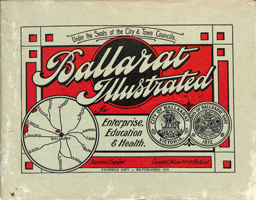
Book, "Ballarat Illustrated", 1972
... Victoria St. looking East, with tram track prominent in photo and how stone work was set up about the rails and overhead poles. Page 23: Street scene, Gardens North Entrance gates, shows details of gates near St. Aidans Drive. Note double trolley wire on poles, and style of insulators. No trams in photo, three ladies walking down the track. Page 37: Street Scene; Lydiard St views, top left hand photo, shows Railway...Victoria St. looking East, with tram track prominent in photo and how stone work was set up about the rails and overhead poles. Page 23: Street scene, Gardens North Entrance gates, shows details of gates near St. Aidans Drive. Note double trolley wire on poles, and style of insulators. No trams in photo, three ladies walking down the track. Page 37: Street Scene; Lydiard St views, top left hand photo, shows Railway ...Original c 1914 (see below), facsimile copy - re-published 1972. Original features photos of Ballarat City and Town, its buildings, parks and the various industries and organisations that were in Ballarat at the time of publication, including ESCo. Many photos features ESCo trams. Photos sepia toned. Has some red colour block printing on the front cover and rear, for Star Oil Engines. On inside back cover is a map with the places of interest and tram route map, marked in red. Pages are un-numbered. Original published by Ballarat East Town Council and Ballaarat City Council. On cover has number stamped in black in, "No. 87" (assume facsimile copy No.). Photos with publication show tram No. 21, built 1913 and ESCo photo page shows Mr. Pringle as Manager. Mr Pringle became manager in January 1911, As there is no photos of the "Avenue of Honour", or other mention of the first world war, assume original published about 1913 or 1914. Original shows Engravings and printing by "Campbell Wilson Prop Ltd, Ballarat". See Other Information as well for more listing details. High Resolution image added 31/8/2012 of i2 of ESCo page and i3 for Ballarat identies and sheet i4 extracted for Mr Pringle. PDF scan of full document added 21/5/2019 - see images btm633-1i.pdf and btm633-2i.pdf Notes on "Ballarat Illustrated" Reg. Item No. 733 From notes made by Neville Gower 12/1/1997 Cover: Inside front cover: Last paragraph, "Facilities for Travelling" - Electric trams serve all parts of Ballarat. Page 3: Street Scene, Municipal Town Hall, showing tram wiring Page 7: Street Scene, Lydiard St. North, intersection and tramway centre, with ESCo tram No. 21 in the bottom photo. Other photos features trams as well in Sturt St and Lydiard St. North. Page 9: Street Scene, Top photo of Sturt St. from Lydiard St. looking east, shows piles on right-hand side of road. Car parked by Post Office has a car registration number "9007". Bottom photo, an tram climbing hill, shows double trolley in the street, with early English type of pull offs. Page 13: Street Scenes and Historic Buildings: One of five photos, shows Victoria St. looking East, with tram track prominent in photo and how stone work was set up about the rails and overhead poles. Page 23: Street scene, Gardens North Entrance gates, shows details of gates near St. Aidans Drive. Note double trolley wire on poles, and style of insulators. No trams in photo, three ladies walking down the track. Page 37: Street Scene; Lydiard St views, top left hand photo, shows Railway station and railway gates with signal gantry and horse drawn vehicles. Tram tracks apparent. Bottom left hand photo shows Lydiard St. North, near Post Office, double track with centre poles - Single wire per track. Top right hand photo, showing Cemetery gates in background. Bottom right hand photo - from north end of Lydiard St. South, looking north, with an ESCo tram in background. Also has a parked car on left hand side. Page 45: Street Scenes - Bridge St; top photo at west end of Bridge St. with ESCo No. 11 with possibly double trolley wire in photo. Bottom photo at east end of Bridge St. with tram in background, shows junction. Double trolley heading out to Mt. Pleasant, single trolley for Victoria St. Page 45: Street Scenes - Bridge St; top photo at west end of Bridge St. with ESCo No. 11 with possibly double trolley wire in photo. Bottom photo at east end of Bridge St. with tram in background, shows junction. Double trolley heading out to Mt. Pleasant, single trolley for Victoria St. Page 61: Street Scenes and Historic Buildings - Public Institutions Ballarat - top left hand photo of the Hospital shows some tram track in foreground, with double trolley wire. Top right photo is of the Orphanage, the name of the tram terminus for many years. Page 68: Electric Supply Co. of Victoria's pages - top photo showing powerhouse in background, across the lake, can hardly see anything for the trees, except for the chimney. Bottom photos of the steam Turbo Generators and the switchboard. Gives Mr. P.J. Pringle as Chief Engineer and General Manager. He took over in Jan. 1911. Page 69: Ballarat East Views - features photo of Black Hill open cut, Ballarat East Railway Station, Ballarat Fire Station and "Victoria St. looking East", repeat of photo printed on page 12, but slightly darker. Image on system includes fire station and railway station, - Ballarat East. Page 78: Series of photos of various Ballarat VIP's of the era, fourth one in on top line features "P.J.Pringle, Electric Supply Co." Inside Back cover - map of Ballarat including tram lines and places of interest marked in red. Gives a detailed photographic presentation of Ballarat in 1914.80 page book with, in addition, light green card covers, titled "Ballarat Illustrated". Loose copy of page 9 and 10 held.trams, tramways, ballarat, local history, heritage buildings, esco -
 Ballarat Tramway Museum
Slide - 35mm slide/s, Peter Moses, 21/08/1971 12:00:00 AM
... North for the arrival of the ARHS special on Saturday 21/8/1971 to undertake the last tour of Ballarat Tramways, prior to the closure of the system. The first line closure (Victoria St.) took place the following day. Has Reid's Coffee Palace building in the background and other buildings on the east side of Lydiard St. North. Two other single truck cars in the photo as are the railway...North for the arrival of the ARHS special on Saturday 21/8/1971 to undertake the last tour of Ballarat Tramways, prior to the closure of the system. The first line closure (Victoria St.) took place the following day. Has Reid's Coffee Palace building in the background and other buildings on the east side of Lydiard St. North. Two other single truck cars in the photo as are the railway ...Photo of SEC Ballarat No. 14 and possibly No. 42 (Briquette roof advertisement and features on the same special trams in Reg. item 2064) waiting in Lydiard St. North for the arrival of the ARHS special on Saturday 21/8/1971 to undertake the last tour of Ballarat Tramways, prior to the closure of the system. The first line closure (Victoria St.) took place the following day. Has Reid's Coffee Palace building in the background and other buildings on the east side of Lydiard St. North. Two other single truck cars in the photo as are the railway gates at the station. Kodak cardboard mount slide, taken by Peter Moses 21 August 1971.On back of slide in light black ink "N14 Ballarat / ARHS / 4 trams special Lydiard St" and "P. Moses" in black ink in the upper right hand side of the slide.tramways, trams, arhs, lydiard st north, railway crossing, tram 14, tram 42 -
 Sunshine and District Historical Society Incorporated
Document - Solomon Heights Ecological Assessment Final Report, Ecology and Heritage Partners Pty Ltd, 22nd January 2016
... North, Munro Avenue to the South, Vermont Avenue to the East and the railway line to the West. The results of the report found 78 flora species (35 indigenous and 43 non-indigenous), 2 native reptiles, 2 introduced mammals, 12 birds (8 natives and 4 introduced) and 1 native invertebrate were recorded in the study area. Solomon Heights Sunshine North Final Report Ecological Assessment, Solomon Heights (Munro Avenue to Whitehill Avenue) Sunshine North, Victoria ...Solomon Heights in Sunshine North is a 1920s subdivision that was never built, later rezoned industrial, and today remains an undeveloped patchwork of grasslands, quarries, and paper roads. The estate is named after Michael Solomon, an early pastoralist whose 1830s sheep station and nearby Solomon’s Ford were key early European landmarks on the Maribyrnong River. This report was undertaken to identify and characterise the vegetation on-site, to determine the presence (or likelihood thereof) of any significant flora and fauna species and/or ecological communities and address any implications under Commonwealth and State environmental legislation. The area of Solomon Heights covered by this report is the southern half, Whitehill Avenue to the North, Munro Avenue to the South, Vermont Avenue to the East and the railway line to the West.The results of the report found 78 flora species (35 indigenous and 43 non-indigenous), 2 native reptiles, 2 introduced mammals, 12 birds (8 natives and 4 introduced) and 1 native invertebrate were recorded in the study area.Final Report Ecological Assessment, Solomon Heights (Munro Avenue to Whitehill Avenue) Sunshine North, Victoria Prepared for Glen Ora Estate Pty Ltd January 2016 Ecology and Heritage Parnters Pty Ltdsolomon heights, sunshine north -
 Marysville & District Historical Society
Book - Paperback book, Timber Mountain, 1986
... Marysville & District Historical Society 39 Darwin Street Marysville yarra-valley-and-the-dandenong-ranges history sawmilling murrindindi forest victoria north east victoria houghton, n Stamp of Marysville & District / Historical Society Inc / P.O. Box 22 / Marysville 3779 Paperback. Front cover has an old photograph of a timber railway leading into a forest. ...Paperback. Front cover has an old photograph of a timber railway leading into a forest. There is also a man standing at the side of the railway. In the inside back cover is a fold out map titled "Sawmills & Tramways of the Murrindindi Forest 1885-1950.Stamp of Marysville & District / Historical Society Inc / P.O. Box 22 / Marysville 3779history, sawmilling, murrindindi forest, victoria, north east victoria, houghton, n -
 Marysville & District Historical Society
Book - Paperback book, Timber Mountain, 1986
... Marysville & District Historical Society 39 Darwin Street Marysville yarra-valley-and-the-dandenong-ranges history sawmilling murrindindi forest victoria north east victoria houghton, n Paperback. Front cover has an old photograph of a timber railway leading into a forest. ...Paperback. Front cover has an old photograph of a timber railway leading into a forest. There is also a man standing at the side of the railway. In the inside back cover is a fold out map titled "Sawmills & Tramways of the Murrindindi Forest 1885-1950.history, sawmilling, murrindindi forest, victoria, north east victoria, houghton, n -
 Victorian Railway History Library
Book, Anchen, Nick, A Railway To Cudgewa, 2013
... Victorian Railway History Library 39 St Edmonds Rd Prahran Prahran Railroad construction - Victoria - history Railroads - Victoria - Cudgewa - history A history of the Victorian Railway's branch line from Wodonga to Cudgewa in North East Victoria. ill, maps, p.122. ...A history of the Victorian Railway's branch line from Wodonga to Cudgewa in North East Victoria.ill, maps, p.122.non-fictionA history of the Victorian Railway's branch line from Wodonga to Cudgewa in North East Victoria.railroad construction - victoria - history, railroads - victoria - cudgewa - history -
 Victorian Railway History Library
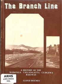
Book, Holmes, Lloyd, The Branch Line: A History of the Wodonga - Tallangatta - Cudgewa Railway, 2013
... Victorian Railway History Library 39 St Edmonds Rd Prahran Prahran Railroad construction - Victoria - history Railroads - Victoria - Cudgewa - history A short history of the Victorian Railway's branch line from Wodonga to Cudgewa in North East Victoria. ill, maps, p.104. ...A short history of the Victorian Railway's branch line from Wodonga to Cudgewa in North East Victoria.ill, maps, p.104.non-fictionA short history of the Victorian Railway's branch line from Wodonga to Cudgewa in North East Victoria.railroad construction - victoria - history, railroads - victoria - cudgewa - history -
 Victorian Railway History Library
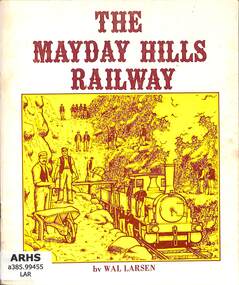
Book, Larsen, Wal, The Mayday Hills Railway 1st edition, 1976
... Victorian Railway History Library 39 St Edmonds Rd Prahran Prahran Railroad construction - Victoria - history Railroads - Victoria - Wangaratta - history A short history of the Victorian Railway's branch line from Wangaratta to Yackandandah in North East Victoria. ill, maps, p.75. ...A short history of the Victorian Railway's branch line from Wangaratta to Yackandandah in North East Victoria.ill, maps, p.75.non-fictionA short history of the Victorian Railway's branch line from Wangaratta to Yackandandah in North East Victoria.railroad construction - victoria - history, railroads - victoria - wangaratta - history -
 Victorian Railway History Library
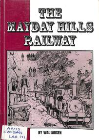
Book, Larsen, Wal, The Mayday Hills Railway
... Victorian Railway History Library 39 St Edmonds Rd Prahran Prahran Railroad construction - Victoria - history Railroads - Victoria - Wangaratta - history A short history of the Victorian Railway's branch line from Wangaratta to Yackandandah in North East Victoria. ill, maps, p.84. ...A short history of the Victorian Railway's branch line from Wangaratta to Yackandandah in North East Victoria.ill, maps, p.84.non-fictionA short history of the Victorian Railway's branch line from Wangaratta to Yackandandah in North East Victoria.railroad construction - victoria - history, railroads - victoria - wangaratta - history -
 Victorian Railway History Library
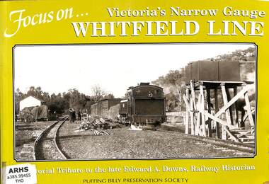
Book, Thompson, John E, Focus On... Victoria's Narrow Gauge Whitefield Line, 2002
... Victorian Railway History Library 39 St Edmonds Rd Prahran Prahran Railroad construction - Victoria - history Railroads - Victoria - Whitfield - history A Pictorial history of the Victorian Railways narrow gauge 2'6" branch line from Wangaratta to Whitfield in North East Victoria, & a tribute to the late Edward A. ...A Pictorial history of the Victorian Railways narrow gauge 2'6" branch line from Wangaratta to Whitfield in North East Victoria, & a tribute to the late Edward A. Downs, Railway Historian.ill, maps, p.41.non-fictionA Pictorial history of the Victorian Railways narrow gauge 2'6" branch line from Wangaratta to Whitfield in North East Victoria, & a tribute to the late Edward A. Downs, Railway Historian.railroad construction - victoria - history, railroads - victoria - whitfield - history -
 Victorian Railway History Library
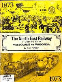
Book, Turton, Keith, The North East Railway A Lineside Guide Melbourne to Wodonga, 1973
... Victorian Railway History Library 39 St Edmonds Rd Prahran Prahran Railroad construction - Victoria - history railroads - victoria - Wodonga - history A lineside guide to the Victorian Railway's North East Railway from Melbourne to Wodonga in Victoria, for the North East Railway Centenary Special Train Tour on the 24th November 1973. ill, maps, p.51. ...A lineside guide to the Victorian Railway's North East Railway from Melbourne to Wodonga in Victoria, for the North East Railway Centenary Special Train Tour on the 24th November 1973.ill, maps, p.51.non-fictionA lineside guide to the Victorian Railway's North East Railway from Melbourne to Wodonga in Victoria, for the North East Railway Centenary Special Train Tour on the 24th November 1973.railroad construction - victoria - history, railroads - victoria - wodonga - history -
 Victorian Railway History Library
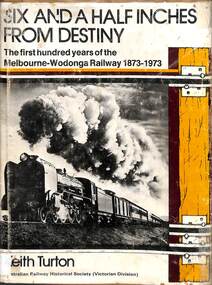
Book, Turton, Keith, Six and a Half Inches From Destiny, 1973
... Victorian Railway History Library 39 St Edmonds Rd Prahran Prahran Railroad construction - Victoria - history railroads - victoria - Wodonga - history A history of the Victorian Railway's North East Railway from Melbourne to Wodonga in Victoria from 1873 to 1973. index, ill, maps, p.133. ...A history of the Victorian Railway's North East Railway from Melbourne to Wodonga in Victoria from 1873 to 1973.index, ill, maps, p.133.non-fictionA history of the Victorian Railway's North East Railway from Melbourne to Wodonga in Victoria from 1873 to 1973.railroad construction - victoria - history, railroads - victoria - wodonga - history -
 Victorian Railway History Library
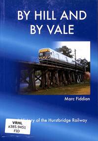
Book, Fiddian, Marc, By Hill and By Vale, 2012
... Victorian Railway History Library 39 St Edmonds Rd Prahran Prahran Railroad construction - Victoria - history Hurstbridge - railway - history A history of the Hurstbridge railway in the north east suburbs of Melbourne. index, ill, p.82. ...A history of the Hurstbridge railway in the north east suburbs of Melbourne.index, ill, p.82.non-fictionA history of the Hurstbridge railway in the north east suburbs of Melbourne.railroad construction - victoria - history, hurstbridge - railway - history