Showing 427 items matching "north kew"
-
 Kew Historical Society Inc
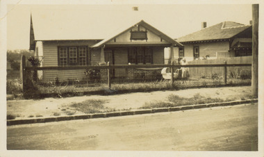
Photograph - 8 Kellett Grove, North Kew, 1929
... 8 Kellett Grove, North Kew...8 Kellett Gove -- North Kew...North Kew, now divided between Kew and Kew East, bordered the Yarra River. ...Small sepia snapshot taken of the front of 8 Kellett Grove, in what was then known as North Kew. ...Verso: 8 KELLETT GROVE / NORTH KEW / 1929 / 41...Photograph 8 Kellett Grove, North Kew ...North Kew, now divided between Kew and Kew East, bordered the Yarra River. As such, it was a region subject to flooding in the Yarra Valley. Development beyond this point (ie Kellett Grove) was limited by the City of Kew's planning regulations. Prior to urban development, the area since European settlement and the first land sales in the district in the 1840s, had been used for dairy farming. Small sepia snapshot taken of the front of 8 Kellett Grove, in what was then known as North Kew. Verso: 8 KELLETT GROVE / NORTH KEW / 1929 / 418 kellett gove -- north kew, californian bungalows, houses -- kellett grove -- kew (vic.) -
 Kew Historical Society Inc
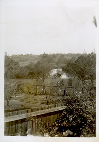
Photograph - View of the Yarra River from 8 Kellett Grove, North Kew, 1948
... View of the Yarra River from 8 Kellett Grove, North Kew...yarra river -- north kew...North Kew, now divided between Kew and Kew East, bordered the Yarra River. ...Small sepia snapshot taken from the back yard of a house at 8 Kellett Grove, in what was then known as North Kew. A tower of the Kew Asylum on the top left of the horizon assist the viewer to recognise that the land to the left of the river is in Kew and Studley Park....Verso: NORTH KEW 1948 / Stamped 51019...Kew Historical Society Inc Kew Court House 188 High Street Kew melbourne North Kew, now divided between Kew and Kew East, bordered the Yarra River. ...North Kew, now divided between Kew and Kew East, bordered the Yarra River. As such, it was a region subject to flooding in the Yarra Valley. Development beyond this point (ie Kellett Grove) was limited by the City of Kew's planning regulations. Prior to urban development, the area since European settlement and the first land sales in the district in the 1840s, had been used for dairy farming. The view from the rear of 8 Kellett Grove predates the construction of the Eastern Freeway so provides a rare view of the area before it was built.Small sepia snapshot taken from the back yard of a house at 8 Kellett Grove, in what was then known as North Kew. A tower of the Kew Asylum on the top left of the horizon assist the viewer to recognise that the land to the left of the river is in Kew and Studley Park.Verso: NORTH KEW 1948 / Stamped 51019yarra river -- north kew, kellett grove -- north kew -
 Kew Historical Society Inc
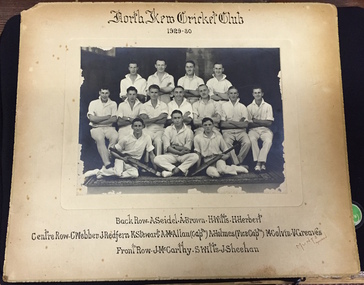
Photograph, Muntz, North Kew Cricket Club 1929-30, c. 1930
... North Kew Cricket Club 1929-30......north kew cricket club...In 1996 when North Kew Cricket Club, which had the Bears as their emblem, merged with the Deepdene Cricket Club. ...Photograph on paperboard of the North Kew Cricket Team of 1929-30. The names of the players are listed under the photograph....NORTH KEW CRICKET CLUB 1929-30 Back Row: A. Seidel | A. ...Kew North, City of Boroondara, Victoria, Australia...North Kew Cricket Club 1929-30 Photograph Photograph Muntz Muntz ...In 1996 when North Kew Cricket Club, which had the Bears as their emblem, merged with the Deepdene Cricket Club. The photograph is of local significance as an image of participation in sport and recreation in North Kew in the decade following the First World War.Photograph on paperboard of the North Kew Cricket Team of 1929-30. The names of the players are listed under the photograph.NORTH KEW CRICKET CLUB 1929-30 Back Row: A. Seidel | A. Brown | H. Wills | H. Herbert. Centre Row: C. Webber | J. Redfern | K. Stewart | A. McAllan (Captn) | A. Holmes (Vice Captn) | M. Colvin | V. Greaves. Front Row: J. McCarthy | S. Wills | J. Sheehan MUNTZ Malvernmuntz, north kew cricket club, a. seidel, a. brown, h. wills, h. herbert, c. webber, j. redfern, k. stewart, a. mcallan, a. holmes, mccolvin, v. greaves, j. mccarthy, s. wills, j. sheehan -
 Kew Historical Society Inc
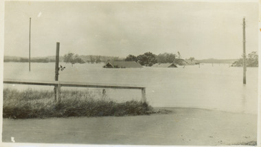
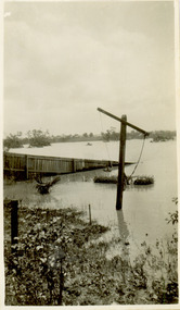
Photograph - Flooding of the Yarra River in North Kew, 1934
... Flooding of the Yarra River in North Kew...yarra river -- north kew...North Kew, now divided between Kew and Kew East, bordered the Yarra River. ...Small sepia snapshot of floodwaters taken from near Willsmere Road, in what was then known as North Kew. The point of view is looking towards Fairfield. ...Verso: WILLSMERE ROAD NORTH KEW / Stamped 3 163...Kew Historical Society Inc Kew Court House 188 High Street Kew melbourne North Kew, now divided between Kew and Kew East, bordered the Yarra River. ...North Kew, now divided between Kew and Kew East, bordered the Yarra River. As such, it was a region subject to flooding in the Yarra Valley. Development beyond this point (ie Kellett Grove) was limited by the City of Kew's planning regulations. Prior to urban development, the area since European settlement and the first land sales in the district in the 1840s, had been used for dairy farming. Small sepia snapshot of floodwaters taken from near Willsmere Road, in what was then known as North Kew. The point of view is looking towards Fairfield. In the foreground are two figures viewing a group in a rowboat in the middle of the flooded river. Semi-submerged street lighting indicates that entire streets had been. overwhelmed by the flood waters. Verso: WILLSMERE ROAD NORTH KEW / Stamped 3 163yarra river -- north kew, floods -- yarra valley, floods -- north kew, floods -- 1934, natural disasters -- kew, willsmere road -
 Ballarat Heritage Services
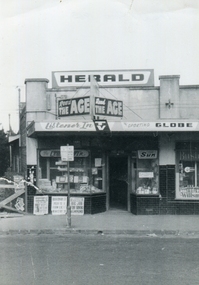
Photograph - Photograph - Black and White, North Kew Authorised Newsagency, c1964, c1964
... North Kew Authorised Newsagency, c1964...north kew authorised newsagency...Black and white of North Kew Authorised Newsagency and Post Office before renovations, including building over driveway to the left of the building. ...93 Willsmere Rd, North Kew, Victoria, Australia...It was owned and run by John Hogan Gervasoni and Kathleen Gervasoni for seventeen years from c1959. north kew authorised newsagency post office newsagency john hogan gervasoni kathleen gervasoni north kew North Kew Newsagency Black and white of North Kew Authorised Newsagency and Post Office before renovations, including building over driveway to the left of the building. ...This photograph was taken before a major renovation of the shop. It was owned and run by John Hogan Gervasoni and Kathleen Gervasoni for seventeen years from c1959.Black and white of North Kew Authorised Newsagency and Post Office before renovations, including building over driveway to the left of the building. north kew authorised newsagency, post office, newsagency, john hogan gervasoni, kathleen gervasoni, north kew, north kew newsagency -
 Kew Historical Society Inc
Photograph - Flooding of the Yarra River in North Kew, 1934
... Flooding of the Yarra River in North Kew...yarra river -- north kew...North Kew, now divided between Kew and Kew East, bordered the Yarra River. ...Small sepia snapshot of what was then River Avenue, North Kew submerged by floodwaters.The photo was taken in the vicinity of 8 Kellett Grove, North Kew. ...Photograph Flooding of the Yarra River in North Kew ...North Kew, now divided between Kew and Kew East, bordered the Yarra River. As such, it was a region subject to flooding in the Yarra Valley. Development beyond this point (ie Kellett Grove) was limited by the City of Kew's planning regulations. Prior to urban development, the area since European settlement and the first land sales in the district in the 1840s, had been used for dairy farming. .Small sepia snapshot of what was then River Avenue, North Kew submerged by floodwaters.The photo was taken in the vicinity of 8 Kellett Grove, North Kew. Verso: TAKEN FROM OUR STREET JUST SEE A BIT OF RYAN'S FENCE / 1934yarra river -- north kew, floods -- yarra valley, floods -- north kew, floods -- 1934, natural disasters -- kew -
 Kew Historical Society Inc
Photograph - Flooding of the Yarra River in North Kew, 1934
... Flooding of the Yarra River in North Kew...yarra river -- north kew...North Kew, now divided between Kew and Kew East, bordered the Yarra River. ...Small sepia snapshot of floodwaters in North Kew, from the rear of 8 Kellett Grove. ...Photograph Flooding of the Yarra River in North Kew ...North Kew, now divided between Kew and Kew East, bordered the Yarra River. As such, it was a region subject to flooding in the Yarra Valley. Development beyond this point (ie Kellett Grove) was limited by the City of Kew's planning regulations. Prior to urban development, the area since European settlement and the first land sales in the district in the 1840s, had been used for dairy farming. Small sepia snapshot of floodwaters in North Kew, from the rear of 8 Kellett Grove. Verso: OUR BACKYARD / Stamped 52yarra river -- north kew, floods -- yarra valley, floods -- north kew, floods -- 1934, natural disasters -- kew, willsmere road -
 Ballarat Heritage Services
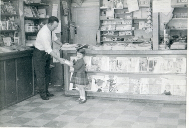
Photograph - Black and White, North Kew Authorised Newsagency, c1964, c1964
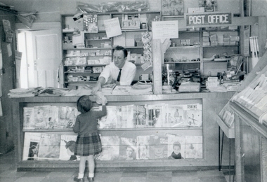
... North Kew Authorised Newsagency, c1964...North Kew Authorised Newsagency...Black and white photograph John Hogan Gervasoni and his daughter, Ann Gervasoni, in North Kew Authorised Newsagency and Post Office....93 Willsmere Rd, North Kew, Victoria, Australia...North Kew Authorised Newsagency, c1964 Photograph - Black and White ...This photograph was taken before a major renovation of the shop.Black and white photograph John Hogan Gervasoni and his daughter, Ann Gervasoni, in North Kew Authorised Newsagency and Post Office.north kew authorised newsagency, post office, newsagency, john hogan gervasoni, ann gervasoni -
 Ballarat Heritage Services
Photograph - Black and White, North Kew Authorised Newsagency, c1964, c1964
... North Kew Authorised Newsagency, c1964...north kew authorised newsagency...Black and white photograph John Hogan Gervasoni and his daughter, Ann Gervasoni, in North Kew Authorised Newsagency and Post Office....93 Willsmere Rd, North Kew, Victoria, Australia...North Kew Authorised Newsagency, c1964 Photograph - Black and White ...This photograph was taken before a major renovation of the shop.Black and white photograph John Hogan Gervasoni and his daughter, Ann Gervasoni, in North Kew Authorised Newsagency and Post Office.north kew authorised newsagency, post office, newsagency, john hogan gervasoni, ann gervasoni -
 Ballarat Heritage Services
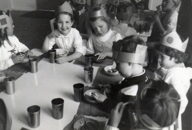
Photograph - Colour, North Kew Kindergarten, c1966
... North Kew Kindergarten, c1966...North Kew Kindergarten...Children at North Kew Kindergarten celebrate the birthday of Clare Gervasoni (far right in crown). ...Pakington Street, North Kew, Victoria, Australia...Ballarat Heritage Services PO Box 2209 Bakery Hill Post Office goldfields North Kew Kindergarten Clare Gervasoni birthday Children at North Kew Kindergarten celebrate the birthday of Clare Gervasoni (far right in crown). ...Children at North Kew Kindergarten celebrate the birthday of Clare Gervasoni (far right in crown). Left to right: ?, Greer ?, Penny ? , Clare Gervasoni, ?, ?.north kew kindergarten, clare gervasoni, birthday -
 Ballarat Heritage Services
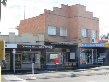
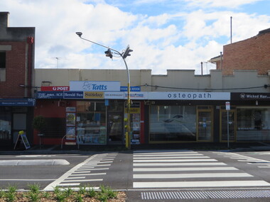
Pamphlet - Photograph, Clare Gervasoni, North Kew Village Shopping Centre, 2017, 10/07/2017
... North Kew Village Shopping Centre, 2017...north kew newsagency...North Kew Village Shopping Centre, Willsmere Road...Willsmere Road, Kew North, Victoria, Victoria, Australia...Ballarat Heritage Services PO Box 2209 Bakery Hill Post Office goldfields north kew newsagency north kew village newsagent willsmere road, kew north Martin Solomons B.L. ...North Kew Village Shopping Centre, Willsmere Roadnorth kew newsagency, north kew village, newsagent, willsmere road, kew north, martin solomons, b.l. butcher, chemist -
 Kew Historical Society Inc
Photograph - Flooding of the Yarra River in North Kew, 1934
... Flooding of the Yarra River in North Kew...yarra river -- north kew...North Kew, now divided between Kew and Kew East, bordered the Yarra River. ...Small sepia snapshot of a local family's house in what was then River Avenue, North Kew being surrounded by floodwaters....Photograph Flooding of the Yarra River in North Kew ...North Kew, now divided between Kew and Kew East, bordered the Yarra River. As such, it was a region subject to flooding in the Yarra Valley. Development beyond this point (ie Kellett Grove) was limited by the City of Kew's planning regulations. Prior to urban development, the area since European settlement and the first land sales in the district in the 1840s, had been used for dairy farming. .Small sepia snapshot of a local family's house in what was then River Avenue, North Kew being surrounded by floodwaters.Verso: THE SIDE OF RYANSyarra river -- north kew, floods -- yarra valley, floods -- north kew, floods -- 1934, natural disasters -- kew -
 Ballarat Heritage Services
Photograph, Clare Gervasoni, North Kew Newsagency, 93 Willsmere Road, North Kew, 2017, 10/07/2017
... North Kew Newsagency, 93 Willsmere Road, North Kew, 2017...North Kew Newsagency...North Kew Newsagency, 93 Willsmere Road, North Kew....Ballarat Heritage Services PO Box 2209 Bakery Hill Post Office goldfields North Kew Newsagency North Kew Village newsagent Willsmere Road, Kew North North Kew Newsagency, 93 Willsmere Road, North Kew. ...North Kew Newsagency, 93 Willsmere Road, North Kew.north kew newsagency, north kew village, newsagent, willsmere road, kew north -
 Kew Historical Society Inc
Photograph - Flooding of the Yarra River in North Kew, 1934
... Flooding of the Yarra River in North Kew...yarra river -- north kew...North Kew, now divided between Kew and Kew East, bordered the Yarra River. ...Small sepia snapshot of floodwaters in North Kew. The point of view is of two houses belonging to local families that were surrounded by floodwater. ...Photograph Flooding of the Yarra River in North Kew ...North Kew, now divided between Kew and Kew East, bordered the Yarra River. As such, it was a region subject to flooding in the Yarra Valley. Development beyond this point (ie Kellett Grove) was limited by the City of Kew's planning regulations. Prior to urban development, the area since European settlement and the first land sales in the district in the 1840s, had been used for dairy farming. Small sepia snapshot of floodwaters in North Kew. The point of view is of two houses belonging to local families that were surrounded by floodwater. Verso: HYATTS HOUSE / WILLSMERE ROAD / Stamped 3 163yarra river -- north kew, floods -- yarra valley, floods -- north kew, floods -- 1934, natural disasters -- kew, willsmere road -
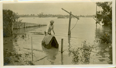 Kew Historical Society Inc
Photograph - Flooding of the Yarra River in North Kew, 1934
... Flooding of the Yarra River in North Kew...yarra river -- north kew...North Kew, now divided between Kew and Kew East, bordered the Yarra River. ...Small sepia snapshot of the donors grandfather rescuing the family dog's kennel from rising floodwaters at the rear of 8 Kellett Grove, North Kew, ....Kew Historical Society Inc Kew Court House 188 High Street Kew melbourne North Kew, now divided between Kew and Kew East, bordered the Yarra River. ...North Kew, now divided between Kew and Kew East, bordered the Yarra River. As such, it was a region subject to flooding in the Yarra Valley. Development beyond this point (ie Kellett Grove) was limited by the City of Kew's planning regulations. Prior to urban development, the area since European settlement and the first land sales in the district in the 1840s, had been used for dairy farming. Vivid photograph contrasting domestic life and relationships with natural disasters such as the flood of 1934.Small sepia snapshot of the donors grandfather rescuing the family dog's kennel from rising floodwaters at the rear of 8 Kellett Grove, North Kew, .Verso: DAD SECURING NIPPY'S DOG KENNEL / Stamped 6414yarra river -- north kew, floods -- yarra valley, floods -- north kew, floods -- 1934, natural disasters -- kew -
 Kew Historical Society Inc
Photograph - Flooding of the Yarra River in North Kew, 1934
... Flooding of the Yarra River in North Kew...yarra river -- north kew...North Kew, now divided between Kew and Kew East, bordered the Yarra River. ...Small sepia snapshot taken from the back yard of a house at 8 Kellett Grove, in what was then known as North Kew. The point of view is from a backyard looking towards Fairfield. ...Photograph Flooding of the Yarra River in North Kew ...North Kew, now divided between Kew and Kew East, bordered the Yarra River. As such, it was a region subject to flooding in the Yarra Valley. Development beyond this point (ie Kellett Grove) was limited by the City of Kew's planning regulations. Prior to urban development, the area since European settlement and the first land sales in the district in the 1840s, had been used for dairy farming. Small sepia snapshot taken from the back yard of a house at 8 Kellett Grove, in what was then known as North Kew. The point of view is from a backyard looking towards Fairfield. Verso: 8 KELLETT GROVEyarra river -- north kew, floods -- yarra valley, floods -- north kew, floods -- 1934, natural disasters -- kew -
 Kew Historical Society Inc
Photograph - Flooding of the Yarra River in North Kew, 1934
... Flooding of the Yarra River in North Kew...yarra river -- north kew...North Kew, now divided between Kew and Kew East, bordered the Yarra River. ...Small sepia snapshot taken from the back yard of a house at 8 Kellett Grove, in what was then known as North Kew. The point of view is from a backyard looking towards Fairfield. ...Photograph Flooding of the Yarra River in North Kew ...North Kew, now divided between Kew and Kew East, bordered the Yarra River. As such, it was a region subject to flooding in the Yarra Valley. Development beyond this point (ie Kellett Grove) was limited by the City of Kew's planning regulations. Prior to urban development, the area since European settlement and the first land sales in the district in the 1840s, had been used for dairy farming. Small sepia snapshot taken from the back yard of a house at 8 Kellett Grove, in what was then known as North Kew. The point of view is from a backyard looking towards Fairfield. Verso: OUR BACKYARD 8 KELLETT GROVEyarra river -- north kew, floods -- yarra valley, floods -- north kew, floods -- 1934, natural disasters -- kew -
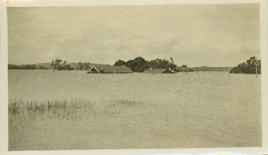
 Kew Historical Society Inc
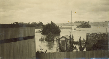
Photograph - Flooding of the Yarra River in North Kew, 1934
... Flooding of the Yarra River in North Kew...yarra river -- north kew...North Kew, now divided between Kew and Kew East, bordered the Yarra River. ...Small sepia snapshot of the devastation caused by the 1934 flood.The photo was taken in the vicinity of Kellett Grove, North Kew and includes the roof of Chipperfield's Boathouse as well as other local houses....Kew Historical Society Inc Kew Court House 188 High Street Kew melbourne North Kew, now divided between Kew and Kew East, bordered the Yarra River. ...North Kew, now divided between Kew and Kew East, bordered the Yarra River. As such, it was a region subject to flooding in the Yarra Valley. Development beyond this point (ie Kellett Grove) was limited by the City of Kew's planning regulations. Prior to urban development, the area since European settlement and the first land sales in the district in the 1840s, had been used for dairy farming. .Small sepia snapshot of the devastation caused by the 1934 flood.The photo was taken in the vicinity of Kellett Grove, North Kew and includes the roof of Chipperfield's Boathouse as well as other local houses.Verso: THIS IS CHIPPERFIELD'S BOAT SHEDS & COES & WILLIAMS TAKEN FROM OUR STREET / 1934yarra river -- north kew, floods -- yarra valley, floods -- north kew, floods -- 1934, natural disasters -- kew, chipperfields boathouse -
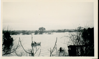 Kew Historical Society Inc
Photograph - Flooding of the Yarra River in North Kew, 1934
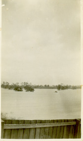
... Flooding of the Yarra River in North Kew...yarra river -- north kew...North Kew, now divided between Kew and Kew East, bordered the Yarra River. ...Small sepia snapshot of floodwaters taken from near Kellett Grove, in what was then known as North Kew. The point of view is from a backyard looking towards Fairfield. ...Kew Historical Society Inc Kew Court House 188 High Street Kew melbourne North Kew, now divided between Kew and Kew East, bordered the Yarra River. ...North Kew, now divided between Kew and Kew East, bordered the Yarra River. As such, it was a region subject to flooding in the Yarra Valley. Development beyond this point (ie Kellett Grove) was limited by the City of Kew's planning regulations. Prior to urban development, the area since European settlement and the first land sales in the district in the 1840s, had been used for dairy farming. Small sepia snapshot of floodwaters taken from near Kellett Grove, in what was then known as North Kew. The point of view is from a backyard looking towards Fairfield. In the foreground ar two men in a rowboat.Verso: OUR BACKYARD / Stamped 3 163yarra river -- north kew, floods -- yarra valley, floods -- north kew, floods -- 1934, natural disasters -- kew -
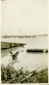
 Kew Historical Society Inc
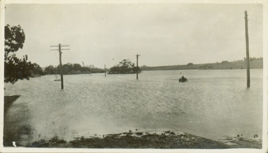
Photograph - Submerged houses in River Avenue, North Kew, 1934
... Submerged houses in River Avenue, North Kew...yarra river -- north kew...North Kew, now divided between Kew and Kew East, bordered the Yarra River. ...Small sepia snapshot of two submerged houses belonging to local families in River Avenue, North Kew, during the 1934 floods. The view is presumably from near Kellett Grove looking north towards Fairfield....Kew Historical Society Inc Kew Court House 188 High Street Kew melbourne North Kew, now divided between Kew and Kew East, bordered the Yarra River. ...North Kew, now divided between Kew and Kew East, bordered the Yarra River. As such, it was a region subject to flooding in the Yarra Valley. Development beyond this point (ie Kellett Grove) was limited by the City of Kew's planning regulations. Prior to urban development, the area since European settlement and the first land sales in the district in the 1840s, had been used for dairy farming. Vivid photograph contrasting domestic life and relationships with natural disasters such as the flood of 1934.Small sepia snapshot of two submerged houses belonging to local families in River Avenue, North Kew, during the 1934 floods. The view is presumably from near Kellett Grove looking north towards Fairfield.Verso: COES & HYATTS ROOF / RIVER AVENUE / Stamped: 6414yarra river -- north kew, floods -- yarra valley, floods -- north kew, floods -- 1934, natural disasters -- kew -
 Kew Historical Society Inc
Photograph - Flooding of the Yarra River in North Kew, 1934
... Flooding of the Yarra River in North Kew...yarra river -- north kew...North Kew, now divided between Kew and Kew East, bordered the Yarra River. ...Small sepia snapshot taken from the back yard of a house at 8 Kellett Grove, in what was then known as North Kew. The point of view is from a backyard looking towards Fairfield. ...Kew Historical Society Inc Kew Court House 188 High Street Kew melbourne North Kew, now divided between Kew and Kew East, bordered the Yarra River. ...North Kew, now divided between Kew and Kew East, bordered the Yarra River. As such, it was a region subject to flooding in the Yarra Valley. Development beyond this point (ie Kellett Grove) was limited by the City of Kew's planning regulations. Prior to urban development, the area since European settlement and the first land sales in the district in the 1840s, had been used for dairy farming. Small sepia snapshot taken from the back yard of a house at 8 Kellett Grove, in what was then known as North Kew. The point of view is from a backyard looking towards Fairfield. Floodwaters have submerged the fence and a clothes line. Verso: BACKYARD NTH. KEWyarra river -- north kew, floods -- yarra valley, floods -- north kew, floods -- 1934, natural disasters -- kew -
 Kew Historical Society Inc
Photograph - Flooding of the Yarra River in North Kew, 1934
... Flooding of the Yarra River in North Kew...yarra river -- north kew...North Kew, now divided between Kew and Kew East, bordered the Yarra River. ...Small sepia snapshot taken from the river ramp of a house at 8 Kellett Grove, in what was then known as North Kew. The point of view is from a backyard looking towards Fairfield. ...Kew Historical Society Inc Kew Court House 188 High Street Kew melbourne North Kew, now divided between Kew and Kew East, bordered the Yarra River. ...North Kew, now divided between Kew and Kew East, bordered the Yarra River. As such, it was a region subject to flooding in the Yarra Valley. Development beyond this point (ie Kellett Grove) was limited by the City of Kew's planning regulations. Prior to urban development, the area since European settlement and the first land sales in the district in the 1840s, had been used for dairy farming. Small sepia snapshot taken from the river ramp of a house at 8 Kellett Grove, in what was then known as North Kew. The point of view is from a backyard looking towards Fairfield. Beyond the fence line are two almost submerged houses. A number of people are in a motor driven boat midstream. Fairfield at this period, (ie 1934) was noted for its limited river side development. Verso: 2/12/34 / TAKEN FROM OUR RAMPyarra river -- north kew, floods -- yarra valley, floods -- north kew, floods -- 1929, floods -- 1934, natural disasters -- kew -
 Kew Historical Society Inc
Photograph, Kilby Road, North Kew, 1916
... Kilby Road, North Kew...north kew...Kilby Road, North Kew 1916. ...Kew Historical Society Inc Kew Court House 188 High Street Kew melbourne north kew farming (kew) wade's farm (kew) Annotation Reverse: "Kilby Road about 1916. ...Kilby Road, North Kew 1916. Annotation Reverse: "Kilby Road about 1916. Courtesy Mrs E. Bennett, Kew East."north kew, farming (kew), wade's farm (kew) -
 Ballarat Heritage Services
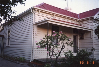
Photograph - Colour, 70 Tennyson St, North Kew, c1973, 08/03/1990
... 70 Tennyson St, North Kew, c1973...70 tennyson st, north kew...A weatherboard house in Tennyson Street, North Kew. ...Ballarat Heritage Services PO Box 2209 Bakery Hill Post Office goldfields Chellowdene was demolished c1995, and four units were built on the block. 70 tennyson st, north kew A weatherboard house in Tennyson Street, North Kew. 70 Tennyson St, North Kew, c1973 Photograph - Colour ...Chellowdene was demolished c1995, and four units were built on the block.A weatherboard house in Tennyson Street, North Kew. 70 tennyson st, north kew -
 Ballarat Heritage Services
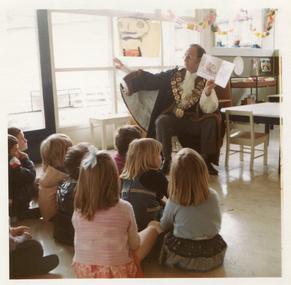
Photograph - Colour, City of Kew Mayor, Cr John H. Gervasoni at North Kew Kindergarten, c1972
... City of Kew Mayor, Cr John H. Gervasoni at North Kew Kindergarten...north kew kindergarten...Colour photograph of Mayor Cr Jack Gervasoni reading a story at NOrth Kew Kindergarten. ...Ballarat Heritage Services PO Box 2209 Bakery Hill Post Office goldfields north kew kindergarten john hogan gervasoni mayor city of kew Colour photograph of Mayor Cr Jack Gervasoni reading a story at NOrth Kew Kindergarten. ...Colour photograph of Mayor Cr Jack Gervasoni reading a story at NOrth Kew Kindergarten. north kew kindergarten, john hogan gervasoni, mayor, city of kew -
 Kew Historical Society Inc
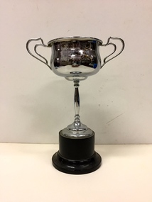
Award, North Kew Cricket Club, NKCC Bowling Ave Won by A. C. Seidel, 1930-1
... ...north kew cricket club...Seidel who was part of the North Kew Cricket Club premiership team in 1930-31. ...North Kew Cricket Club...Seidel Award Award North Kew Cricket Club ...Silver plated trophy on a brown bakelite stand awarded to A.C. Seidel who was part of the North Kew Cricket Club premiership team in 1930-31. A photograph of the team which includes A.C. Seidel is also in the Kew Historical Society's collection."N. K. C. C. / Bowling Ave / Won by A. C. Seidel / 1930-31"a.c. seidel, north kew cricket club, trophies -
 Kew Historical Society Inc
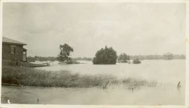
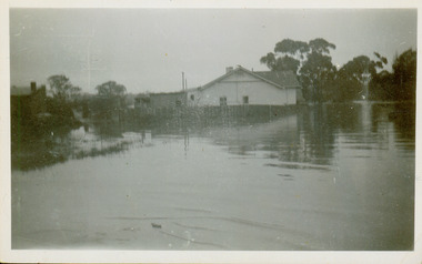
Collection, Floods in North Kew (Series), 1929–1934
... Floods in North Kew (Series)...Yarra River -- North Kew...Flooding of the Yarra Valley, including that section of the Yarra bordering Kew and Kew East in the north and west of the municipality, was a regular occurrence. ...Collection of 16 monochrome photographs, annotated on verso by different hands, of the flooding of the River Yarra in North Kew in the third and fourth decades of the twentieth century [1920s & 1930s]. ...Yarra River -- North Kew Floods -- Yarra Valley Floods -- North Kew Floods -- 1929 Floods -- 1934 Natural disasters -- Kew Collection of 16 monochrome photographs, annotated on verso by different hands, of the flooding of the River Yarra in North Kew in the third and fourth decades of the twentieth century [1920s & 1930s]. ...Flooding of the Yarra Valley, including that section of the Yarra bordering Kew and Kew East in the north and west of the municipality, was a regular occurrence. Extreme flood events of the Yarra River are recorded to have occurred in 1891, 1901, 1916, 1923 and 1934. The Municipality of Kew's response to these floods was to enact planning decisions restricting residential development in flood prone areas following the floods of 1916, 1921 and 1934. While floods continued after the development of the Upper Yarra Reservoir (construction 1948-57), the regularity and extent of these inundations diminished. Natural disasters had an impact on the development and settlement of Melbourne and its suburbs. Flooding in the Melbourne region was a regular event in the nineteenth and for most of the twentieth centuries. Changes in the impact of natural disasters could occur due to a number of factors. This collection of small snapshots, mostly taken from Kellett Grove in North Kew, provide provenanced evidence of flooding in the area before the development of the unnatural flood barrier that is the Eastern Freeway.Collection of 16 monochrome photographs, annotated on verso by different hands, of the flooding of the River Yarra in North Kew in the third and fourth decades of the twentieth century [1920s & 1930s]. Individual photos include the dates of different floods. Many of the photos were taken from the rear of 8 Kellett Grove; a house still extant in 2023yarra river -- north kew, floods -- yarra valley, floods -- north kew, floods -- 1929, floods -- 1934, natural disasters -- kew -
 Kew Historical Society Inc
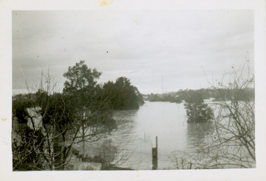
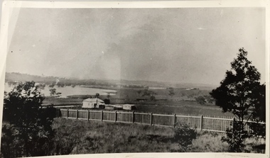
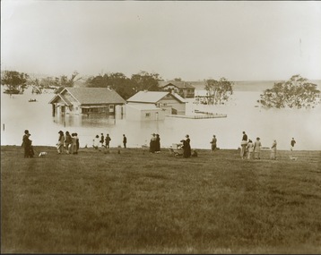
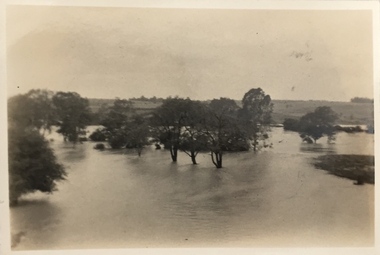
Photograph - Yarra in Flood from Willsmere, North Kew, 1923
... Yarra in Flood from Willsmere, North Kew ...Flooding of the Yarra Valley, including that section of the Yarra bordering Kew and Kew East in the north and west of the municipality, was a regular occurrence. ...Original, large sepia photograph showing men, women and children who have gathered on a grassy verge, probably farm land, to look out across the flooded Yarra Valley at Willsmere, North Kew. In the medium distance are three houses that are largely submerged by the flood waters as well as a number of Eucalypts. ...Kew North, Greater Melbourne, Victoria, Australia...Photograph Yarra in Flood from Willsmere, North Kew ...Flooding of the Yarra Valley, including that section of the Yarra bordering Kew and Kew East in the north and west of the municipality, was a regular occurrence. Extreme flood events of the Yarra River are recorded to have occurred in 1891, 1901, 1916, 1923 and 1934. The Municipality of Kew's response to these floods was to enact planning decisions restricting residential development in flood prone areas following the floods of 1916, 1921, and 1934. While floods continued after the development of the Upper Yarra Reservoir (construction 1948-57), the regularity and extent of these inundations diminished. Original, large sepia photograph showing men, women and children who have gathered on a grassy verge, probably farm land, to look out across the flooded Yarra Valley at Willsmere, North Kew. In the medium distance are three houses that are largely submerged by the flood waters as well as a number of Eucalypts. Inscribed reverse: "Gift of Kerrie Woollard (KCC) (P)C.1923yarra river valley, kew east (vic.), floods, willsmere -
 Ballarat Heritage Services
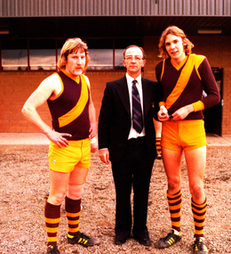
Photograph - digital copy, K.P. Gervasoni, North Kew Rovers footballers Peter Cooper and Niall McAllister with Mayor of Kew Cr Jack Gervasoni),1979, 1979
... North Kew Rovers footballers Peter Cooper and Niall McAllister with Mayor of Kew Cr Jack Gervasoni),1979 ...Jack and Kathleen Gervasoni ran the North Kew Authorised Newsagency at 93 Willsmere Road for 17 years. ...Copy of colour photograph of two North Kew Rovers Footballers with City of Kew Mayor Cr John H. ...Ballarat Heritage Services PO Box 2209 Bakery Hill Post Office goldfields Jack and Kathleen Gervasoni ran the North Kew Authorised Newsagency at 93 Willsmere Road for 17 years. ...Jack and Kathleen Gervasoni ran the North Kew Authorised Newsagency at 93 Willsmere Road for 17 years. Peter Cooper and Niall McAllister where two of a multitude of paperboys who worked at the newsagency.Copy of colour photograph of two North Kew Rovers Footballers with City of Kew Mayor Cr John H. Gervasoni. Left to right: Peter Cooper, Jack Gervasoni, Niall McAllister at Stradbroke Park, Kewkew, gervasoni, jack gervasoni, mayor, team, sport, football, cooper, stradbroke park, peter cooper, neil mcalister, paperboys, j.h. gervasoni, niall mcalister -
 Kew Historical Society Inc
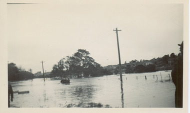
Photograph, Floods in North Kew, 1934
... Floods in North Kew...Willsmere Road, North Kew....Willsmere Road, North Kew. Floods in North Kew Photograph Photograph ...The great flood of 1934 in Melbourne was one of the most devastating floods since records began. The floods affected all of Melbourne, including Kew.Locally significant photographs of the impact of flooding in Kew in 1934Floods in North Kew, 1934. Flood near Lagoon (Billabong?) Willsmere Road, North Kew.floods (kew) 1934, yarra river