Showing 114 items matching "nt"
-
 Bendigo Military Museum
Photograph - RA Svy Project C4 Aerodist Operation, Eastern Arnhem Land, NT, 1967
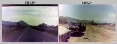
... RA Svy Project C4 Aerodist Operation, Eastern Arnhem Land, NT...From July to October 1967 the aircraft was attached to Central Comd Fd Svy Unit (Adelaide - Major Don Ridge) on Project C4 eastern-Arnhem Land NT, where 317 Aerodist lines measuring 17,300 line miles were successfully completed. ...Aero Commander VH-EXX probably at Gove, NT. Unidentified personnel. .26) - Photo, black & white, 1967. ....1P to .2P – date and location on edge of film negative. .5P to .28P – no annotations .29P - annotated in white ‘RW-JEP Gove NT’ .30P - annotated in white ‘U337 Spool No1 Jun67’...Gove, Eastern Arnhem Land, NT...RA Svy Project C4 Aerodist Operation, Eastern Arnhem Land, NT Photograph RA Svy Project C4 Aerodist Operation, Eastern Arnhem Land, NT Army Survey Regiment ...This is a set of 30 photographs of Royal Australian Survey Corps (RA Svy) personnel from Central Comd Fd Svy Unit (Adelaide) on Aerodist survey operation - Project C4 in Eastern Arnhem Land, Northern Territory in 1967. Photos of personnel were taken either at the operations base at Numbulwar or the main base at Gove (Nhulunbuy). RA Svy conducted nineteen Aerodist operations for 12 years from 1964 to 1975. Aerodist MRC2 was a tellurometer-based system adapted for aircraft to accurately measure distances between non-intervisible ground survey stations, using the aircraft as an intermediate station. Lower order geodetic results could be achieved by survey network trilateration. The measured distances between stations formed survey networks from which each station’s latitude and longitude was computed. Aerodist MRC2 was RA Svy’s major horizontal control survey tool for mainly medium scale topographic mapping (scale 1:100,000 Class A being spatially accurate to within 50 metres) in PNG, northern NT, north-west WA, Kalimantan Barat (West) Indonesia, Sumatra Indonesia, Gulf of Carpentaria and Cape York, QLD. In 1967, the Aerodist MRC2 Master equipment was installed in the aircraft featured in this set of photos, Executive Air Services’ (Essendon VIC) Grand Aero Commander VH-EXX. It was the same aircraft type and company contracted to Division of National Mapping for Aerodist MRC2 surveys. From July to October 1967 the aircraft was attached to Central Comd Fd Svy Unit (Adelaide - Major Don Ridge) on Project C4 eastern-Arnhem Land NT, where 317 Aerodist lines measuring 17,300 line miles were successfully completed. This was the most productive Aerodist project thus far. The most common helicopter used by RA Svy up to 1972 was the civilian Bell 47G-2 and the Sioux Light Observation Helicopters (LOH), the Australian Army’s equivalent featured in this photo set. These light observation helicopters had a limiting load carrying capacity of up to about 500 pounds. By comparison, one Aerodist team including two people weighed up to 1,500 pounds. Source: Royal Australian Survey Corps – Aerodist Years 1964-1975 by Peter Jensen. Refer to Item 9061.26P for more photos taken during this Aerodist survey operation.This is a set of 30 photographs of Royal Australian Survey Corps (RA Svy) personnel on Aerodist survey operations in Eastern Arnhem Land, Northern Territory in 1967. The photographs are on 35mm negative film and scanned at 96 dpi. They are part of the Army Survey Regiment’s Collection. .1) to .4) - black & white, 20th August 1967, Project C4 Aerodist Operations Base - Numbulwar, NT. .5) - Photo, black & white, 1967. Probable wrecked Indonesian fishing vessel. .6) to .8) - Photo, black & white, 1967. Unidentified survey operations base, L to R: unidentified personnel. .9) - Photo, black & white, 1967. Unidentified survey operations base, unidentified soldier driving a Haflinger 4x4 Light utility vehicle. .10) - Photo, black & white, 1967. Unidentified survey operations base, L to R: unidentified technician. .11) - Unidentified technician reading two survey altimeters to compute corrections to the measured distances for atmospheric refraction and to compute the sea level distances from the slope distances aircraft to the ground stations. .12) - Photo, black & white, 1967. Survey operations base, L to R: unidentified (x3), W01 Pat Wood BEM, unidentified. .13) to .16) - Photo, black & white, 1967. Unidentified personnel operating remote Aerodist MRC2 ground instruments. .17) to .18) - Photo, black & white, 1967. Unknown RA Svy office location. .19) to .20) - Photo, black & white, 1967. Aerodist MRC2 Master equipment. .21) to .22) - Photo, black & white, 1967. Aero Commander VH-EXX probably at Gove, NT, Central Comd Fd Svy Unit (Adelaide) – OC Major Don Ridge. .23) to .25) - Photo, black & white, 1967. Aero Commander VH-EXX probably at Gove, NT. Unidentified personnel. .26) - Photo, black & white, 1967. Aero Commander VH-EXX probably at Gove, NT. Aerodist antenna pods are visible on the aircraft. .27) to .29) - Photo, black & white, 1967. Australian Army Sioux Light Observation Helicopter (LOH) probably at Gove, NT. .30) - Photo, black & white, 1967. Panelled U337 survey station, visible as a white cross on aerial identification photo..1P to .2P – date and location on edge of film negative. .5P to .28P – no annotations .29P - annotated in white ‘RW-JEP Gove NT’ .30P - annotated in white ‘U337 Spool No1 Jun67’royal australian survey corps, rasvy, army survey regiment, army svy regt, fortuna, asr, aerodist, surveying, central comd fd svy unit -
 Bendigo Military Museum
Photograph - RA Svy Project C4 Aerodist Operation, Eastern & Western Arnhem Land, NT, 1967, 1968
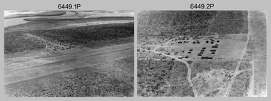
... RA Svy Project C4 Aerodist Operation, Eastern & Western Arnhem Land, NT...In 1968, after completion of the Kimberley Aerodist Operation project, the Aerodist system in VH-EXX was immediately deployed to western-Arnhem Land NT for Central Comd Fd Svy Unit (Adelaide - Major Don Ridge) to complete the mapping control across northern NT from mid-July to October. ...The following photos are annotated in black ink on edge of film negative: .3P – ’15 Aug ’68, 2000’, 1-C18 ’68 MILINGIMBI SIERRA’ .4P – ’U462’ .8P – ‘1-C3/67 Float Removed’ .13P – ‘U477 10-C3/67 .20P - ‘2-C3/67 Bank of Chargers’ .21P - ‘3-C3/67 Gallows & Scales’ .22P - ‘0462 VERONICA ISLAND NT, CPL Larkin’ .23P - ‘0462 VERONICA ISLAND NT’ .24P - ‘4-C3/67 20’ Aerodist Tower’ .25P - ‘5-C3/67 20’ Aerodist Tower’ .26P - ‘6-C3/67 20’ Aerodist Tower’...Gove, Eastern Arnhem Land, NT...RA Svy Project C4 Aerodist Operation, Eastern & Western Arnhem Land, NT Photograph RA Svy Project C4 Aerodist Operation, Eastern & Western Arnhem Land, NT Army Survey Regiment ...This is a set of 26 photographs of Royal Australian Survey Corps (RA Svy) personnel from Central Comd Fd Svy Unit (Adelaide) on Aerodist survey operation - Project C4 in Eastern Arnhem Land, Northern Territory in 1967 (photos .4P to .26P) and in Western Arnhem Land, Northern Territory in 1968 (photos .1P to .3P). Photos of personnel were taken either at the operations base at Numbulwar or the main base at Gove (Nhulunbuy). RA Svy conducted nineteen Aerodist operations for 12 years from 1964 to 1975. Aerodist MRC2 was a tellurometer-based system adapted for aircraft to accurately measure distances between non-intervisible ground survey stations, using the aircraft as an intermediate station. Lower order geodetic results could be achieved by survey network trilateration. The measured distances between stations formed survey networks from which each station’s latitude and longitude was computed. Aerodist MRC2 was RA Svy’s major horizontal control survey tool for mainly medium scale topographic mapping (scale 1:100,000 Class A being spatially accurate to within 50 metres) in PNG, northern NT, north-west WA, Kalimantan Barat (West) Indonesia, Sumatra Indonesia, Gulf of Carpentaria and Cape York, QLD. In 1967, the Aerodist MRC2 Master equipment was installed in the aircraft featured in this set of photos, Executive Air Services’ (Essendon VIC) Grand Aero Commander VH-EXX. It was the same aircraft type and company contracted to Division of National Mapping for Aerodist MRC2 surveys. From July to October 1967 the aircraft was attached to Central Comd Fd Svy Unit (Adelaide - Major Don Ridge) on Project C4 eastern-Arnhem Land NT, where 317 Aerodist lines measuring 17,300 line miles were successfully completed. This was the most productive Aerodist project thus far. The most common helicopter used by RA Svy up to 1972 was the civilian Bell 47G-2 and the Sioux Light Observation Helicopters (LOH), the Australian Army’s equivalent featured in this photo set. These light observation helicopters had a limiting load carrying capacity of up to about 500 pounds. By comparison, one Aerodist team including two people weighed up to 1,500 pounds. In 1968, after completion of the Kimberley Aerodist Operation project, the Aerodist system in VH-EXX was immediately deployed to western-Arnhem Land NT for Central Comd Fd Svy Unit (Adelaide - Major Don Ridge) to complete the mapping control across northern NT from mid-July to October. The Aerodist MRC2 Remote antenna seen in Photos .24P to .26P is mounted on a 20 foot pole tower. The antenna direction was controlled by wires/ropes to the two arms under the dish at right angles. The antenna elevation could be changed to the vertical for aircraft height checks as seen in photo .25P. Source: Royal Australian Survey Corps – Aerodist Years 1964-1975 by Peter Jensen. Refer to Item 6449.30P for more photos taken during these Aerodist survey operations.This is a set of 26 photographs of Royal Australian Survey Corps (RA Svy) personnel on Aerodist survey operations in Eastern Arnhem Land, Northern Territory in 1967 and Western Arnhem Land, Northern Territory in 1968. The photographs are on 35mm negative film and scanned at 96 dpi. They are part of the Army Survey Regiment’s Collection. .1) to .2) – Photo, black & white, 1968, unidentified soldier with an opened can of food, possibly bully beef. .3) – Photo, black & white, 15 Aug 1968, aerial view of terrain taken from a helicopter in vicinity of MILINGIMBI SIERRA. .4) – Photo, black & white, 1967, aerial view of an island taken from a helicopter. .5) & .6) – Photo, black & white, 1967, unidentified soldier driving a Haflinger 4x4 Light utility vehicle with trailer. .7) – Photo, black & white, 1967, unidentified surveyors taking vertical measurements with a leveling instrument and staff. .8) – Photo, black & white, 1967, Australian Army Sioux Light Observation Helicopter (LOH) with float removed. .9) to .11) – Photo, black & white, 1967, Australian Army Sioux Light Observation Helicopter (LOH) with floats. .12) – Photo, black & white, 1967, civilian Bell 47G-2 helicopter (Australian Army Sioux LOH equivalent) refuelled. .13) – Photo, black & white, 1967, survey station on coastline surrounded by white plastic aerial photographic identification panels lined with rocks. .14) & .15) – Photo, black & white, 1967, soldier (possibly a signaller from RA Sigs) operating a radio. .16) – Photo, black & white, 1967, Central Comd Fd Svy Unit Operations Section tent, Main Base Gove (Nhulunbuy) L to R: SPR Harry Dunn, WO1 Pat Wood BEM. .17) – Photo, black & white, 1967, Central Comd Fd Svy Unit Operations Section tent, Main Base Gove (Nhulunbuy) L to R: unidentified, WO1 Pat Wood BEM. .18) – Photo, black & white, 1967, Central Comd Fd Svy Unit Operations Section, Main Base Gove (Nhulunbuy), unidentified Australian Army Catering Corps cook preparing meals. .19) – Photo, black & white, 1967, Central Comd Fd Svy Unit Operations Section, Main Base Gove (Nhulunbuy) mess tent in readiness for meals. .20) – Photo, black & white, 1967, Bank of batteries in transit boxes undergoing recharging using generators. .21) – Photo, black & white, 1967, A topographic survey identification plaque set in a concrete block being weighed using a set of scales hanging from slaughtering gallows. .22) – Photo, black & white, 1967, CPL (Geoff or Gary) Larkin operating the remote Aerodist MRC2 ground instrument at Veronica Island, located north of Nhulunbuy. .23) – Photo, black & white, 1967, L to R: CPL (Geoff or Gary) Larkin with unidentified surveyor operate the remote Aerodist MRC2 ground instrument at Venica Island, located north of Nhulunbuy. .24) & .25 – Photo, black & white, 1967, The Aerodist MRC2 Remote antenna. .26) – Photo, black & white, 1967, The Aerodist MRC2 Remote antenna.The following photos are annotated in black ink on edge of film negative: .3P – ’15 Aug ’68, 2000’, 1-C18 ’68 MILINGIMBI SIERRA’ .4P – ’U462’ .8P – ‘1-C3/67 Float Removed’ .13P – ‘U477 10-C3/67 .20P - ‘2-C3/67 Bank of Chargers’ .21P - ‘3-C3/67 Gallows & Scales’ .22P - ‘0462 VERONICA ISLAND NT, CPL Larkin’ .23P - ‘0462 VERONICA ISLAND NT’ .24P - ‘4-C3/67 20’ Aerodist Tower’ .25P - ‘5-C3/67 20’ Aerodist Tower’ .26P - ‘6-C3/67 20’ Aerodist Tower’royal australian survey corps, rasvy, army survey regiment, army svy regt, fortuna, asr, aerodist, surveying, central comd fd svy unit -
 Bendigo Military Museum
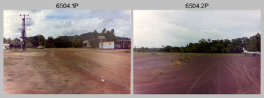
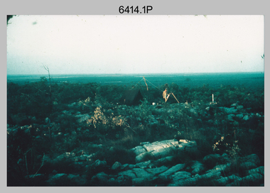
Photograph - 4th Field Survey Squadron – Operation NERVOSE 85 Field Phase Oblique Photos, NT, 1985
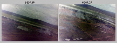
... 4th Field Survey Squadron – Operation NERVOSE 85 Field Phase Oblique Photos, NT...Victoria River Downs, NT...Unknown locations. 4th Field Survey Squadron – Operation NERVOSE 85 Field Phase Oblique Photos, NT Photograph 4th Field Survey Squadron – Operation NERVOSE 85 Field Phase Oblique Photos, NT Army Survey Regiment ...This is a set of 20 oblique aerial photographs taken during the field phase of 4th Field Survey Squadron’s Operation NERVOSE 85 project in the Northern Territory in 1985. Operation NERVOSE 85 was mounted by 4 Fd Svy Sqn in the EAST ARNHEM, VICTORIA RIVER DOWNS AND DALY WATERS areas of the Northern Territory from 26 May to 18 Sep 85. The aim of Operation NERVOSE 85 was to finalise the horizontal and vertical control for mapping at a scale of 1:50,000, to field check 40x 1:50,000 preliminary maps and to obtain mapping photography in support of the RAAF TINDAL redevelopment project. *Note –These photos were most likely taken in 1985, contrary to the ‘1987’ date annotated on the negative sleeves. The Op NERVOSE 85 Project Report available on RASVY’s web site lists a nominal roll of personnel. Photos of 4 Fd Svy Sqn taken in 1985 and 1987 provide names of posted personnel. Several personnel identified in these photos were posted to 4 Fd Svy Sqn in 1985, not in 1987. See items 6504.13P, 6505.28P and 6506.16P for more photos taken prior to and during Operation NERVOSE 1985. This is a set of 20 oblique aerial photographs taken during the field phase of 4th Field Survey Squadron’s Operation NERVOSE 85 project in the Northern Territory in 1985. The colour photographs on 35mm negative film and are part of the Army Survey Regiment’s Collection. The photographs were scanned at 96 dpi. .1) to .20) - Photo, colour, 1985. Unknown locations..1P to .20P – There are no personnel identified. ‘1987 OP NERVOSE VICTORIA RIVER DOWNS AND DALY WATERS.’ annotated on negative sleeve.royal australian survey corps, rasvy, 4 fd svy sqn, op nervose 85 -
 Bendigo Military Museum
Booklet - A survey of the North Australian Coast on AK121 Aroetta, NT Force, NT Coastal Recce Unit RAE, 6 Aust Army Topo Survey Corps, AKA121 Aroetta, 28 Mar 1945
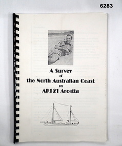
... Signed by George Barton Maj. for LtCol GS. NT Force...NT Force, NT Coastal Recce Unit RAE, 6 Aust Army Topo Survey Corps, AKA121 Aroetta...Royal Australian Survey Corps RASvy Fortuna Army Survey Regiment Army Svy Regt ASR Signed by George Barton Maj. for LtCol GS. NT Force A4 Booklet, plain paper with text and diagrams and half tone photograph of Lt Jack Worsley with plastic binder A survey of the North Australian Coast on AK121 Aroetta Booklet A survey of the North Australian Coast on AK121 Aroetta NT Force, NT Coastal Recce Unit RAE, 6 Aust Army Topo Survey Corps, AKA121 Aroetta ...The work of the Australian Survey Corps is to make maps for the Army. At the outbreak of war very little of the mainland had been mapped, especially the northern parts. The best maps in existence of the N.T. coast in Dec "41 were those made by Matt Flinders in 1801 -1802. The Army soon got out new maps of all important areas including much of the inland. Later it was decided to bring the complete coastline up to date. Several parties put in between them six months on the coast during the dry season of "45 but a couple more months would be needed to complete the program when the "wet" interrupted the work. A small section from Buckingham Bay - Groote Eylandt was still untouched and this diary covers that section of the N.T. Coast. A survey party of four men was chosen who were to be transported from place to place by the AK121 Aroetta - a ketch of 25 tons belonging to an army unit called N.T. Coastal Recce whose work it was to patrol the coast and as well do air - sea rescue. The survey party: Lieut Jack Worsley (the Loot) Sgt Jack Love, Spr Jack Cook, Spr Pat Hede. Crew of Aroetta: Liet Ralph Warne (Skipper), Sgt Buckley (Buck) (First Mate and Orderly Rm), Sgt Jim Terjesen (Jumbo) Bosun, WO2 Tom Davis (Engineer), Cpl Kevin Monk (Artificer), L/Cpl Jack Cox (Deck Hand), Spr Jack Andrews (Signals), Spr Laurie Rament (Ass. Engineer), Spr McKenzie (Mac) (Cook). The complete history is not available after July 31 1945. The remainder of the notes are very badly water-damaged and in some places unreadable.A4 Booklet, plain paper with text and diagrams and half tone photograph of Lt Jack Worsley with plastic binderSigned by George Barton Maj. for LtCol GS. NT Forceroyal australian survey corps, rasvy, fortuna, army survey regiment, army svy regt, asr -
 Ringwood and District Historical Society
Envelope, Packet: Aboriginal Queen of the Koongarra Khung (NT). Maroondah Reconciliation (2002); 1964 Letter from Margaret Edwards
... Packet: Aboriginal Queen of the Koongarra Khung (NT). Maroondah Reconciliation (2002); 1964 Letter from Margaret Edwards...+Additional Keywords: Edwards, Margaret Packet: Aboriginal Queen of the Koongarra Khung (NT). Maroondah Reconciliation (2002); 1964 Letter from Margaret Edwards Envelope ...Aboriginal Queen of the Koongarra Khung, N.T.;; Letter, handwritten.;; Newspaper articles: Qty 3. +Additional Keywords: Edwards, Margaret -
Moorabbin Air Museum
Model (Item) - De Havilland Drover VH-AZS NT Medical Service scale 1:72
... De Havilland Drover VH-AZS NT Medical Service scale 1:72...Moorabbin Air Museum Moorabbin Airport 12 First Street Moorabbin melbourne De Havilland Drover VH-AZS NT Medical Service scale 1:72 Model De Havilland Drover VH-AZS NT Medical Service scale 1:72 ... -
Moorabbin Air Museum
Document (item) - Darwin NT brief summary of bombing 1942 and operations in 1945
... Darwin NT brief summary of bombing 1942 and operations in 1945...Moorabbin Air Museum Moorabbin Airport 12 First Street Moorabbin melbourne The author of this document is not known but covers his time in Darwin and other areas with 2 and 13 Squadrons and USAAF 528 and 23 Squadrons Darwin NT brief summary of bombing 1942 and operations in 1945 Document Darwin NT brief summary of bombing 1942 and operations in 1945 ...The author of this document is not known but covers his time in Darwin and other areas with 2 and 13 Squadrons and USAAF 528 and 23 Squadrons -
 Narre Warren and District Family History Group
CD, Office of the Registrar General NT, Northern Territory births, deaths and marriages : 1870-1913
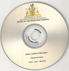
... Office of the Registrar General NT...Narre Warren and District Family History Group 110 High Street Berwick melbourne Northern Territory NT - births NT - marriages NT - deaths Northern Territory historical index - births, deaths and marriages : 1870-1913 (B1918) 1 optical disc Northern Territory births, deaths and marriages : 1870-1913 CD Office of the Registrar General NT ...Northern Territory historical index - births, deaths and marriages : 1870-1913 (B1918)1 optical discnon-fictionNorthern Territory historical index - births, deaths and marriages : 1870-1913 (B1918)northern territory, nt - births, nt - marriages, nt - deaths -
 Alfred Hospital Nurses League - Nursing History Collection
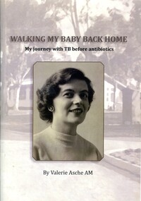
Booklet - Illustraed booklet, Valerie Asche 1927-2019, Walking my baby back home: my journey with TB before antibiotics, 2011
... ...uniprint NT...Title and author's name in black print above and below sketch of building and trees in background Walking my baby back home: my journey with TB before antibiotics Booklet Illustraed booklet Valerie Asche 1927-2019 uniprint NT ...This story is about the author starting off her studies at University only to become ill with pleurisy, which did not improve, the result was a break in University studies, bed rest and a referral to the part-time Director of Tuberculosis in Victoria. The author describes the different phases of her illness, her life at Greenvale Sanatorium, her friendships with other patients, her family and the subsequent treatment in the 1940's for people suffering with TB. Greenvale was a close knit environment, everyone was fighting to stay alive, but some didn't.Stapled illustrated booklet, Black and white photograph of the author as a young woman on front cover. Title and author's name in black print above and below sketch of building and trees in backgroundnon-fictionThis story is about the author starting off her studies at University only to become ill with pleurisy, which did not improve, the result was a break in University studies, bed rest and a referral to the part-time Director of Tuberculosis in Victoria. The author describes the different phases of her illness, her life at Greenvale Sanatorium, her friendships with other patients, her family and the subsequent treatment in the 1940's for people suffering with TB. Greenvale was a close knit environment, everyone was fighting to stay alive, but some didn't.tuberculosis, tuberculosis-medical treatment -
 Bendigo Military Museum
Photograph - 4th Field Survey Squadron – Operation NERVOSE 85 Reconnaissance, Northern Territory, 1985
... Victoria River Downs, NT ...This is a set of 13 photographs taken in 1985* during reconnaissance of locations in regions of the Northern Territory. Later that year, Operation NERVOSE 85 was mounted by 4 Fd Svy Sqn in the EAST ARNHEM, VICTORIA RIVER DOWNS AND DALY WATERS areas of the Northern Territory from 26 May to 18 Sep 85. The aim of Operation NERVOSE 85 was to finalise the horizontal and vertical control for mapping at a scale of 1:50,000, to field check 40x 1:50,000 preliminary maps and to obtain mapping photography in support of the RAAF TINDAL redevelopment project. *Note –These photos were most likely taken in 1985, contrary to the ‘1987’ date annotated on the negative sleeves. The Op NERVOSE 85 Project Report available on RASVY’s web site lists a nominal roll of personnel. Photos of 4 Fd Svy Sqn taken in 1985 and 1987 provide names of posted personnel. Several personnel identified in these photos were posted to 4 Fd Svy Sqn in 1985, not in 1987.This is a set of 13 photographs taken during 4th Field Survey Squadron’s reconnaissance of Operation NERVOSE 85 locations in the Northern Territory in 1985. The colour photographs are on 35mm negative film and are part of the Army Survey Regiment’s Collection. The photographs were scanned at 96 dpi. .1) to .4) - Photo, colour, 1985. Unknown location in the Northern Territory. .5) - Photo, colour, 1985. Unidentified personnel in the back of a police vehicle. .6P to .12) - Photo, colour, 1985. Unknown location in the Northern Territory. .13) - Photo, colour, 1985. L to R: Possibly MAJ A. Vickers RE - UK Exchange Officer from Army Svy Regt, unidentified officer. .1P to .13P – There are no personnel identified. ‘1987 OP NERVOSE – RECON PHOTOG.’ annotated on negative sleeve.royal australian survey corps, rasvy, 4 fd svy sqn, op nervose 85 -
 Bendigo Military Museum
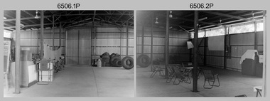
Photograph - 4th Field Survey Squadron – Operation NERVOSE 85 Field Phase, Northern Territory, 1985
... Victoria River Downs, NT ...This is a set of 16 photographs taken in 1985* during 4th Field Survey Squadron’s deployment on Operation NERVOSE 85 in the Northern Territory. Operation NERVOSE 85 was mounted by 4 Fd Svy Sqn in the EAST ARNHEM, VICTORIA RIVER DOWNS AND DALY WATERS areas from 26 May to 18 Sep 85. The aim of Operation NERVOSE 85 was to finalise the horizontal and vertical control for mapping at a scale of 1:50,000, to field check 40x 1:50,000 preliminary maps and to obtain mapping photography in support of the RAAF TINDAL redevelopment project. *Note –These photos were most likely taken in 1985, contrary to the ‘1987’ date annotated on the negative sleeves. The Op NERVOSE 85 Project Report available on RASVY’s web site lists a nominal roll of personnel. Photos of 4 Fd Svy Sqn taken in 1985 and 1987 provide names of posted personnel. Several personnel identified in these photos were posted to 4 Fd Svy Sqn in 1985, not in 1987. See items 6504.13P, 6505.28P and 6507.20P for more photos taken prior to and during Operation NERVOSE 1985. This is a set of 16 photographs taken in 1985 during 4th Field Survey Squadron’s deployment on Operation Nervose in the Northern Territory. The black & white photographs are on 35mm negative film and are part of the Army Survey Regiment’s Collection. The photographs were scanned at 96 dpi. ..1) & .2) - Photo, black & white, 1985. Q-store and OPS Room. .3) & .4) - Photo, black & white, 1985. Base Camp at unknown location. .5) - Photo, black & white, 1985. Personnel spectate during a social cricket match. L to R on left: CPL Andy Lucas, unidentified (x3). L to R on right: unidentified (x4), LTCOL Kevin Murphy – SO1 Svy HQ FF Comd, unidentified, SSGT Barry Lutwyche OAM (closest to camera). .6) - Photo, black & white, 1985. Personnel spectate during a social cricket match. L to R on left: unidentified (x2). L to R on right: unidentified (x3), LCPL Chris ‘Charlie’ Brown (standing up), SSGT Barry Lutwyche OAM (closest to camera), LTCOL Kevin Murphy – SO1 Svy HQ FF Comd. .7) - Photo, black & white, 1985. CPL Andy Lucas plans an exit strategy from the latrine. .8) to .10) - Photo, black & white, 1985. Social cricket match action. .11) to .14) - Photo, black & white, 1985. LCPL Chris ‘Charlie’ Brown operates a second-generation Transit Doppler satellite Magnavox MX-1502 Satellite Surveyor Geoceiver. .15) to .16) - Photo, black & white, 1985. LCPL Steve McGuiness sets up a Geoceiver antenna..1P to .16P – There are no personnel identified. ‘1987 OP NERVOSE VICTORIA RIVER DOWNS AND DALY WATERS.’ annotated on negative sleeve.royal australian survey corps, rasvy, 4 fd svy sqn, op nervose 85 -
 Bendigo Military Museum
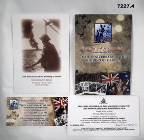
Souvenir - SOUVENIR, BOMBING of DARWIN, 2012
... Invitation to the Ball from Chief Minister of NT to Mr Basil Darby and Guest. 70th Anniversary of Bombing. ...Darwin, NT, Australia...Invitation to the Ball from Chief Minister of NT to Mr Basil Darby and Guest. 70th Anniversary of Bombing. ...Refer service of Pte BASIL DARBY SX9423 2/14 Bn.1. Pamphlet, 70th Anniversary of the Bombing of Darwin Commemorative Service, Sunday, 19 Feb 2012, Darwin Cenotaph. This is a single sheet of cardboard folded to make 4 pages. The image on the front is an Aust soldier in steel helmet, looking over from a ships rail at a column of smoke rising from the edge of the Harbour. 2. Pamphlet - frontline Australia Ball - 70th Anniversary of the Bombing of Darwin. This is 4 sheets of stiff paper - colour printing. It has images, messages from politicians, maps. 3. This is a single small strip of cardboard - useful as a bookmark. It is for the 70th Anniversary of Bombing of Darwin at frontline Australia. It is for a dance dated 18 Feb 2012. 4. Card. Invitation to the Ball from Chief Minister of NT to Mr Basil Darby and Guest. 70th Anniversary of Bombing. Dated - Sunday 19 Feb 2012darwin ww2, darwin 70th anniversary ball -
 Bendigo Military Museum
Photograph - 4th Field Survey Squadron deployed on Operation NERIGHT, Queensland & Northern Territory, 1989
... Part 1 was the field completion of topographic maps conducted near Camooweal QLD, along the Barkley Highway on the border between NT and QLD, from the 12th of September to the 20th of October 1989. ...Camooweal region, QLD & NT...Part 1 was the field completion of topographic maps conducted near Camooweal QLD, along the Barkley Highway on the border between NT and QLD, from the 12th of September to the 20th of October 1989. ...This is a set of 19 photographs taken in 1989 during 4th Field Survey Squadron’s deployment on Operation NERIGHT 89 in Queensland and the Northern Territory. It was a two-part operation in 1989 with work conducted in the areas of Camooweal and Weipa. Part 1 was the field completion of topographic maps conducted near Camooweal QLD, along the Barkley Highway on the border between NT and QLD, from the 12th of September to the 20th of October 1989. A Bell Kiowa LOH helicopter from 162 Recce Sqn supported topographic field completion. Operation NERIGHT 89 Part 2 was the acquisition of mapping control by GPS field parties utilising Texas Instruments TI4100 Global Positioning System receivers around Weipa on Cape York Peninsula from the 22nd of September to the 22nd of October 1989. Part 2 Two Bell UH-1H Iroquois helicopters from RAAF’s 35 Squadron were principally used to deploy GPS field parties. Identification photography of control points was taken by air camera operators in AAAvn Pilatus Porter aircraft from 173 Gen Spt Sqn fitted with an RC10 aerial camera. The two parts of the operation were conducted concurrently. This is a set of 19 photographs taken in 1989 during 4th Field Survey Squadron’s deployment on Operation Neright in Queensland & the Northern Territory. The colour photographs are on 35mm negative film and are part of the Army Survey Regiment’s Collection. The photographs were scanned at 96 dpi. .1) to .3) - Photo, colour, 1989. En-route to areas of survey operations. .4) to .5) - Photo, colour, 1989. Unidentified personnel relax next to river/waterhole. .6) - Photo, colour, 1989. Two Bell UH-1H Iroquois helicopters from RAAF’s 35 SQN utilised in the movement of GPS parties. .7) to .9) - Photo, colour, 1989. Unidentified soldier practices repelling from a UH1H Iroquois helicopter. .10) - Photo, colour, 1989. Inside the cockpit of a UH1H Iroquois helicopter. .11) - Photo, colour, 1989. Field Party camp with GPS equipment in foreground. Unidentified soldier prepares a meal. .12) - Photo, colour, 1989. GPS antenna plumbed over a survey ground mark. Witness post on left. .13) & .14) - Photo, colour, 1989. Unknown Cape York Peninsula beaches. .15) & .16) - Photo, colour, 1989. Dramatic fire next to base camp. .17) - Photo, colour, 1989. Aboriginal rock art at unknown location. .18) - Photo, colour, 1989. Aboriginal rock art at unknown location. L to R: unidentified, SPR Andrew Quin. .19) - Photo, colour, 1989. Aboriginal rock art at unknown location. LT Chris Topovsek..1P to .19P – There are no personnel identified. ‘1989 OP NERIGHT’ annotated on negative sleeve.royal australian survey corps, rasvy, 4 fd svy sqn, op neright 89 -
 Running Rabbits Military Museum operated by the Upwey Belgrave RSL Sub Branch
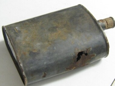
Water Bottle
... Found Near Katherine NT....Running Rabbits Military Museum operated by the Upwey Belgrave RSL Sub Branch 1 Mast Gully Road Upwey melbourne Equipment Found Near Katherine NT. Water Bottle ...Found Near Katherine NT.equipment -
 Running Rabbits Military Museum operated by the Upwey Belgrave RSL Sub Branch
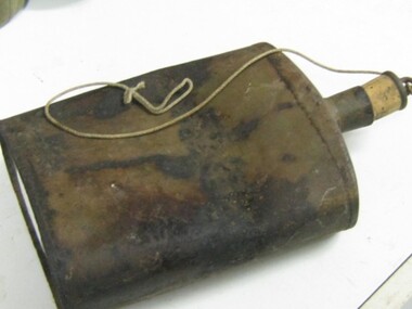
Water Bottle
... Found near Katherine NT....Running Rabbits Military Museum operated by the Upwey Belgrave RSL Sub Branch 1 Mast Gully Road Upwey melbourne Equipment WW2 Found near Katherine NT. Water Bottle ...Found near Katherine NT.equipment, ww2 -
 Bendigo Military Museum
Badge - BADGES, BOMBING of DARWIN, 1990-1992
... Darwin, NT, Australia ...Refer to the service of "BASIL DARBY" SX9423, 2/14 Bn.1. A round bronze colour badge, at top border - words "The Reunion", at bottom border - words - "60th Anniversary 2002". In the centre of the badge are two human head profiles, two spitfires, a ship and possibly a tank with big numerals '60' at bottom. 2. Oval brass coloured badge. On top border is the phrase '70th Anniversary' . At bottom border is the phrase - "Bombing of Darwin". In the centre are a flight of aircraft, tall and short humans and the phrase "1942 Front Line Australia". 3. This is a multi shaped badge. It has a stylised Rising Sun, superimposed on that is a dark red shape of Australia. Under that is a black enamel banner with the phrase "Darwin Defenders 1942-1945". 4. This is a shield shaped badge with a long mounting pin behind it. The shield is a green enamel. In the centre is an 8 pointed gold star. Set on a red background. In that centre is phrase "1992 50th Anniversary" in gold colour. Around the outside of the star is the phrase " The Battle of Australia 50th Anniversary 1992".1. On rear is stamped 1484.badges, bombing of darwin, anniversaries -
Tatura Irrigation & Wartime Camps Museum
Folder, Murakami Family Papers Camp 4 Internees
... Darwin, NT, Australia ...Excerpts from the Northern Territory News Genny O'Loughlin, author, 19 February 1988. Also full fathom five by Mary Albertus Bain.A black folder with the inscription below on outside front cover.Murakami Family Papers Camp 4 Interneesgenny o'loughlin,, mary albertus bain, murakami family, camp 4 internees -
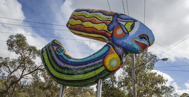 Nillumbik Shire Council
Public Art: Deborah HALPERN, 'Queen of the Shire'; Location: Cnr Kangaroo Ground-Warrandyte Rd & Research-Warrandyte Rd, North Warrandyte, 2015
... 7 Dingley Dell Road, Nt warrandyte, Nillumbik, Melbourne, Victoria, Australia ...Deborah Halpern was raised in Nth Warrandyte. Her connection to the area and the significant contribution that she and her family (founding members of Potters Cottage) have made to the artistic heritage and culture of the Shire is acknowledge with the commission of this piece. Deborah Halpern is a highly recognised and respected local artist with an acclaimed national reputation in the arts community. This work is a gateway piece, welcoming residents and visitors into the Shire from the southern end of the boundary. 'Queen of the Shire' reflects the creative spirit that flows endlessly in the Shire, inspired by the landscape. This work forms part of a series of sculptures that Halpern has created along the banks of the Yarra in Melbourne ('Angel' - Birrarung Marr and 'Ophelia' - Southgate). This sculpture is an excellent example of Halpern’s ouvere and 'tile construction' technique for which she is renowned. Materials: coloured glass tiles, fibreglass, aluminium, steel. A sweeping stylised (female) form covered in bright and colourful tiles held aloft by two steel poles. queen, sculpture, semi-abstract, stylised, glass, tiles, public art, halpern, ek prac 2015 -
 Running Rabbits Military Museum operated by the Upwey Belgrave RSL Sub Branch
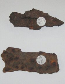
Shrapnel
... 2 Pieces of Schrapnel found near Katherine NT...Running Rabbits Military Museum operated by the Upwey Belgrave RSL Sub Branch 1 Mast Gully Road Upwey melbourne Miscellaneous 1944 Army 2 Pieces of Schrapnel found near Katherine NT Shrapnel ...2 Pieces of Schrapnel found near Katherine NTmiscellaneous, 1944, army -
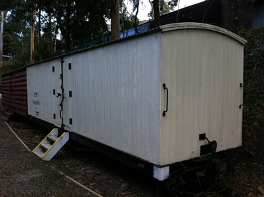 Puffing Billy Railway
1 NT, Victorian Railways 2'6" Gauge Insulated Wagon, 1899
... In 1926, the class was relettered to NT. Obtained by the Puffing Billy Preservation Society By 1969, the vehicle was in the Menzies Creek Museum. ...timber constructed body wall cavity filled with horse hair for insulation The NT is an insulated van. The wooden body (both sides and roof) was insulated with cowhair. ...Victorian Railways 2'6" Gauge Insulated Wagon 1 NT Victorian Railways - Newport Workshop ...INSULATED wagon. Built in 1899 and numbered 1, it was the only one of its type built Service History : NTT In October 1899 a bogie insulated van was built and placed into traffic. In 1926, the class was relettered to NT. Obtained by the Puffing Billy Preservation Society By 1969, the vehicle was in the Menzies Creek Museum. Currently Located at Belgrave Station The NT is an insulated van. The wooden body (both sides and roof) was insulated with cowhair. It had two swinging doors either side in the middle, as have the NU vans. The van was painted white, in an attempt to reflect the summer heat. There was only one built for the narrow gauge lines. Vehicle Length 25 feet 2 inches ( 7671 mm) Coupled Length 27 feet 4 inches (8330 mm) Width 6 feet 3 inches (1905 mm) Weight 7 tons Capacity 10 tons Built 1899 Number Built 1 In use none To be restored 1Historic - Victorian Railways - Narrow Gauge Rolling Stock - Insulated Wagon 1NT Victorian Heritage Register (VHR) Number H2187 Puffing Billy Locomotives and Rolling Stock Collectiontimber constructed body wall cavity filled with horse hair for insulation The NT is an insulated van. The wooden body (both sides and roof) was insulated with cowhair. It had two swinging doors either side in the middle, as have the NU vans. The van was painted white in an attempt to reflect the summer heat. There was only one built for the narrow gauge.1nt1nt, puffing billy, insulated van -
 Bendigo Historical Society Inc.
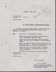
Administrative record - National Trust Collection: Leigh Lodge, 12 Bannerman Street (formerly Selb Villa), 1973
... 3222 B handwritten comments on the undated copy of the NT classification...Bendigo. historic building 3222 B handwritten comments on the undated copy of the NT classification National Trust Collection: Leigh Lodge, 12 Bannerman Street, Bendigo 3222 A - 15 December 1973, letter from Central Victoria Branch National Trust of Australia, Victoria to J. ...Leigh Lodge (formerly Selb Villa) Bendigo, 12 Bannerman St. Bendigo.National Trust Collection: Leigh Lodge, 12 Bannerman Street, Bendigo 3222 A - 15 December 1973, letter from Central Victoria Branch National Trust of Australia, Victoria to J. Barton Esq. that the property at 12 Bannerman Street has received Classification No. 3049, which states: LEIGH LODGE 12 Bannerman St Bendigo. Built approx. 1871-2 according to Municipal Rate Books. Previously named Selb Villa. Stands in half acre with stone stable and coach house, with hay loft, with right of way to Harrison Street. Garden has bricked paths and terraced rock walls of local sand stone. Included in the garden is a Pine Tree reputed to be as old as the house itself. Within the house are original marble fireplaces, moulded cornices and ornamental plaster centre ceiling ornaments. The official Classification was dated May 1968. 3222 B - copy of the classification of Leigh Lodge (as Above), on yellow paper, and handwritten comments. 3222 B handwritten comments on the undated copy of the NT classificationhistoric building -
 Bendigo Historical Society Inc.
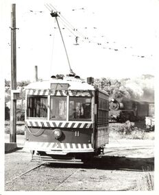
Photograph - BASIL MILLER COLLECTION: TRAM - BENDIGO TRAMWAYS
... No. 11 tram departing Nt. Bendigo terminus, steam on railway line on RH side of tram....History House 11 Mackenzie Street Bendigo goldfields PERSON Individual basil miller No. 11 tram departing Nt. Bendigo terminus, steam on railway line on RH side of tram. ...No. 11 tram departing Nt. Bendigo terminus, steam on railway line on RH side of tram.person, individual, basil miller -
Moorabbin Air Museum
Map (item) - Sheet Layout For The World Aeronautical Chart (WAC) ICAO 1:1000,000, Refer Description For Full Range Of Maps Available
... Comprising the following charts, Normington 3220 Qld Melbourne 3469 Vic Clermont 3234 Qld Roper River 3110 NT Charleville 3341 Qld Townsville 3219 Qld Gloncurry 3233 Qld Canberra 3457 ACT Melbourne 3470 Vic Oodnadatta 3343 Qld Adelaide 3109 SA Darwin 3109 NT Newcastle Waters NT 10th Edition 1988 Alice Springs NT 10th Edition 1988 Tarcoola SA 9th Edition 1988 Broken Hill NSW 10th Edition 1988 Darwin NT 12th Edition 1990 Cookton Qld 11th Edition Hamilton Vic 11 Edition 1989 Cooper Creek Qld 12th Edition Normanton Qld 11th Edition Groote Eyland NT 11th Edition 1989 Townsville Qld 11th Edition 1988 Gloncurry Qld 9th Edition 1988 Clermont Qld 10th Edition 1989 Oodnadatta SA 9th Edition 1988 Peterman Ranges WA 9th Edition 1990 Adelaide SA 11th Edition 1990 ...Comprising the following charts, Normington 3220 Qld Melbourne 3469 Vic Clermont 3234 Qld Roper River 3110 NT Charleville 3341 Qld Townsville 3219 Qld Gloncurry 3233 Qld Canberra 3457 ACT Melbourne 3470 Vic Oodnadatta 3343 Qld Adelaide 3109 SA Darwin 3109 NT Newcastle Waters NT 10th Edition 1988 Alice Springs NT 10th Edition 1988 Tarcoola SA 9th Edition 1988 Broken Hill NSW 10th Edition 1988 Darwin NT 12th Edition 1990 Cookton Qld 11th Edition Hamilton Vic 11 Edition 1989 Cooper Creek Qld 12th Edition Normanton Qld 11th Edition Groote Eyland NT 11th Edition 1989 Townsville Qld 11th Edition 1988 Gloncurry Qld 9th Edition 1988 Clermont Qld 10th Edition 1989 Oodnadatta SA 9th Edition 1988 Peterman Ranges WA 9th Edition 1990 Adelaide SA 11th Edition 1990 Sheet Layout For The World Aeronautical Chart (WAC) ICAO 1:1000,000, Refer Description For Full Range Of Maps Available. ... -
 Bendigo Historical Society Inc.
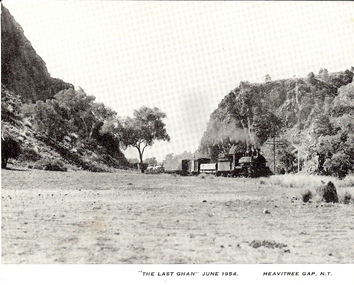
Photograph - BASIL MILLER COLLECTION: THE LAST GHAN
... Labelled 'THE LAST GHAN' JUNE 1954 Heavitree Gap NT'....Labelled 'THE LAST GHAN' JUNE 1954 Heavitree Gap NT'. Photograph BASIL MILLER COLLECTION: THE LAST GHAN ...Black and white image of train passing between hills. Labelled 'THE LAST GHAN' JUNE 1954 Heavitree Gap NT'.person, individual, basil miller -
 Bendigo Historical Society Inc.
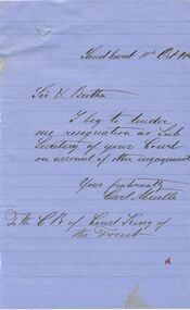
Document - ANCIENT ORDER OF FORESTERS NO. 3770 COLLECTION: CORRESPONDENCE
... Letter of resignation as Sub Secretary of the Court on accou;nt of other engagements, dated 11th Oct 18? ...History House 11 Mackenzie Street Bendigo goldfields SOCIETIES Aof correspondence Ancient Order of Foresters No. 3770 Collection - Correspondence Carl Mueller Court King of the Forest Letter of resignation as Sub Secretary of the Court on accou;nt of other engagements, dated 11th Oct 18? ...Letter of resignation as Sub Secretary of the Court on accou;nt of other engagements, dated 11th Oct 18? Written on bluepaper and signed by Carl Mueller.societies, aof, correspondence, ancient order of foresters no. 3770 collection - correspondence, carl mueller, court king of the forest -
 Victorian Aboriginal Corporation for Languages
Book, Lutheran Church of Australia, A guide to records of Indigenous Australians in the Lutheran Archives, Adelaide, SA, 1999
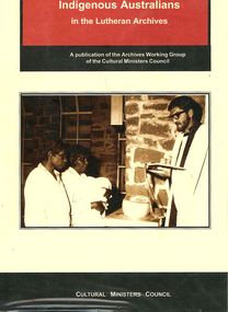
... A valuable resource in assisting Indigenous Australians to locate information from records, from 10 Lutheran Missions in SA, NT, Qld, held in Adelaide....Victorian Aboriginal Corporation for Languages 33 Saxon Street Brunswick melbourne Lutheran Church Lutheran Archives South Australia genealogy Northern Territory Queensland tables A valuable resource in assisting Indigenous Australians to locate information from records, from 10 Lutheran Missions in SA, NT, Qld, held in Adelaide. A guide to records of Indigenous Australians in the Lutheran Archives, Adelaide, SA. ...A valuable resource in assisting Indigenous Australians to locate information from records, from 10 Lutheran Missions in SA, NT, Qld, held in Adelaide.tableslutheran church, lutheran archives, south australia, genealogy, northern territory, queensland -
 Bendigo Military Museum
Photograph - Royal Australian Survey Corps Surveyors in the Field – Northern Territory and Queensland, 1959 – 1960
... Surveyors’ camp in the Peckman Hill area, near Katherine in the NT. .4) - Photo, colour, 1959. Cairn on Trig Hill, Borroloola, NT. ...Surveyors’ camp in the Peckman Hill area, near Katherine in the NT. .4) - Photo, colour, 1959. Cairn on Trig Hill, Borroloola, NT. ...This is a set of 10 photographs of surveyors and support staff in the field undertaking duties in the Northern Territory and North Queensland in 1959 – 1960. The surveyors were employed in the establishment of mapping and geodetic control. In this era surveyors used theodolites to observe horizontal and vertical angles and tellurometers to measure base line distances between survey stations. Laplace survey observations seen in Photo .1P was a series of precise observations carried out at geodetic survey stations to determine astronomic latitudes, longitudes and azimuths to achieve maximum precision in the survey network. Laplace observations were necessary in a geodetic network at every 6th survey station, however the National Mapping Council specified at this time the spacing would be ideally between 4-6 survey stations. The cairn shown in photo .4P was built by RASvy as a landmark over a trigonometric survey station. It was dismantled in 1960 to enable re-occupation and survey observations. It was not restored to the condition shown in the photo.This is a set of 10 photographs of surveyors and support staff in the field undertaking duties in the Northern Territory (NT) and Queensland (QLD) in 1959 – 1960. The photographs were printed on photographic paper and are part of the Army Survey Regiment’s Collection. The photographs were scanned at 300 dpi. .1) - Photo, colour, 1959. Tony Slattery occupying a Laplace survey station on a hill in the Mount Young area of the NT. .2) - Photo, colour, 1959. Surveyors’ camp in the Mount Young area of the NT, L to R: Spencer Snow and Tony Slattery. .3) - Photo, colour, 1959. Surveyors’ camp in the Peckman Hill area, near Katherine in the NT. .4) - Photo, colour, 1959. Cairn on Trig Hill, Borroloola, NT. Built by Spencer Snow, Tom Royle and Jack McCabe. .5) - Photo, colour, 1959. Survey party taking a break next to their Austin Champ vehicle, in transit between Katherine, NT and Wyndam WA. L to R: Tony Slattery, Dave Owens, John Van De Graff. .6) - Photo, colour, 1960. Surveyors’ camp between Mount Isa, QLD and Borroloola, NT. L to R: Pat Cox and John Van De Graff prepare their meal on an open fire. .7) - Photo, colour, 1960. Surveyor - Dennis Woods undertaking survey observations, using MRA1 tellurometer to measure base-line distances NW of Mount Isa, QLD. .8) - Photo, colour, 1960. Unidentified surveyors assessing recovery of their stalled Studebaker truck vehicle after attempting a water crossing in the NT. .9) - Photo, colour, 1960. Unidentified surveyor making batches of bread at a camp in the NT. Seen in the photo placing a lid with hot coals onto the camp oven. .10) - Photo, colour, 1960. Unidentified survey party occupying a survey station on a hill in the Mount near the Lawn Hill area, NW of Mount Isa, QLD. A MRA1 tellurometer to measure base-line distances appear on the right side of the photo. .9) - Photo, colour, 1960. Unidentified surveyors assessing recovery of their stalled Studebaker truck vehicle after attempting a water crossing in the NT. .10) - Photo, colour, 1960. Unidentified surveyor making batches of bread at a camp in the NT. Seen in the photo placing a lid with hot coals onto the camp oven. .1P to .10P annotated on back – personnel names, the year and the location. royal australian survey corps, rasvy, army survey regiment, asr, army svy regt, fortuna, surveying -
 Federation University Art Collection
Work on paper - Artwork - Printmaking, Jack, Kenneth, 'Mt Eccles and Crater Lake, No.3 Volcanic Plains of Victoria ' by Kenneth Kack, 1961
... Framed four plate lithograph depicitng Nt Eccles and Crater Lake on the Victorian cvolcanic plains. ...Federation University Art Collection Artworks are displayed at Federation University Australia campuses at Ballarat, Gippsland (Churchill), Stawell and Horsham. goldfields kenneth jack printmaking mt eccles volcano lithograph Edition 23/42 Framed four plate lithograph depicitng Nt Eccles and Crater Lake on the Victorian cvolcanic plains. ...Framed four plate lithograph depicitng Nt Eccles and Crater Lake on the Victorian cvolcanic plains. Donated through the Australian Gifts Programme by Katherine Littlewood.Edition 23/42kenneth jack, printmaking, mt eccles, volcano, lithograph -
 Bendigo Military Museum
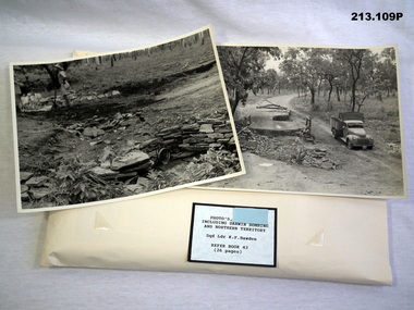
Photograph - PHOTOGRAPHS RAAF, 1942 - 1945
... B & W photos of various sizes, including bombing of Darwin, Rear HQ including Birdum, Daly Waters NT and HQ RAAF in Adelaide....B & W photos of various sizes, including bombing of Darwin, Rear HQ including Birdum, Daly Waters NT and HQ RAAF in Adelaide. Photograph PHOTOGRAPHS RAAF ...The photos were in a collection held by SQD Leader Kenneth Frederick Bawden No 250882 RAAF. Enlistment details are scant. (Born unknown, enlisted unknown) on 4.12.1939, served Darwin area 15.9.1942. - 6.1.1943, after details are near nil but records state there was Pacific area service and was awarded the Pacific Star. At discharge on 28.2.1946 he held the rank of Sqd Ldr at Air Force HQ. Refer 2048.9. Photographs in envelope. B & W photos of various sizes, including bombing of Darwin, Rear HQ including Birdum, Daly Waters NT and HQ RAAF in Adelaide.photography - photographs, australia, war damage -
 Bendigo Military Museum
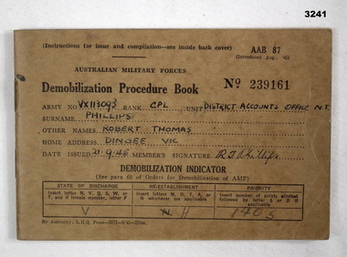
Administrative record - DEMOBILIZATION PROCEDURE BOOK WW2, 8.1945
... From: District Accounts Office NT"...From: District Accounts Office NT" Australian Military Forces Demobilization Procedure Book AAB 87 No 239161. ...item Re R.T.Phillips VX113093, refer Cat No 3239P for his service details.Australian Military Forces Demobilization Procedure Book AAB 87 No 239161. Soft brown cover with black printing. The various pages in this book show the steps a soldier needed to take to be discharged. Several units & dates shown.Soldier: "VX113093, Cpl PHILLIPS Robert Thomas. Home Address Dingee, Vic. Issued: 21.9.45. From: District Accounts Office NT"books-manuals/reference, military history, demobilization