Showing 2 items matching "nuggety lead"
-
 Federation University Historical Collection
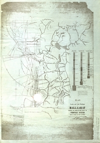
Plan, Plan of Leads and Gold Workings at Baallarat Showing the Complications Under the Frontage System, 1863, 1863
... ...nuggety lead...Barker Library (top floor) Mount Helen goldfields Facsimile of a plan held by the Public Record Office Victoria. ballarat mining inkermann lead golden point lead robert davidson terrible lead white horse lead frenchman's lead little magpie lead milkmaid's lead woolshed lead nuggety lead blackman's lead canadian lead sailor's gully lad nightingale lead malakoff lead black hill gully pennyweight flat black hill winter's pre-emptive right nelson company great extended great republic lead cgt Facsimile of a plan of Ballarat showing leads, gold workings an dthe frontage system. ...Facsimile of a plan held by the Public Record Office Victoria. Facsimile of a plan of Ballarat showing leads, gold workings an dthe frontage system.ballarat, mining, inkermann lead, golden point lead, robert davidson, terrible lead, white horse lead, frenchman's lead, little magpie lead, milkmaid's lead, woolshed lead, nuggety lead, blackman's lead, canadian lead, sailor's gully lad, nightingale lead, malakoff lead, black hill gully, pennyweight flat, black hill, winter's pre-emptive right, nelson company, great extended, great republic lead, cgt -
 Bendigo Historical Society Inc.
Map - RAYWOOD GOLD FIELD MAP, 1902
... Mentions the Parish of Yallook, Parish of Neilborough, Yarraberb, Mushroom Flat, Murray Valley Plain, Eaglehawk and Kerang Railway, Green Hill, Doughboy, Redmond's Gully, Pickpocket Lead, Raywood Lead, Inglewood Lead, Shaw's Road, Nuggety Shaft, Barkly Shaft, Maori Bend...Mentions the Parish of Yallook, Parish of Neilborough, Yarraberb, Mushroom Flat, Murray Valley Plain, Eaglehawk and Kerang Railway, Green Hill, Doughboy, Redmond's Gully, Pickpocket Lead, Raywood Lead, Inglewood Lead, Shaw's Road, Nuggety Shaft, Barkly Shaft, Maori Bend Map RAYWOOD GOLD FIELD MAP ...Map. Raywood Gold Field Map. Linen backed map of Raywood and Neilborough Township and surrounds showing the location of varying underground workings. Surveyed by H S Whitelaw 1/6/02. It shows underground workings from The Perseverance Party and moreshed and Party and underground workings on the Old Pioneer Reef. Mentions the Parish of Yallook, Parish of Neilborough, Yarraberb, Mushroom Flat, Murray Valley Plain, Eaglehawk and Kerang Railway, Green Hill, Doughboy, Redmond's Gully, Pickpocket Lead, Raywood Lead, Inglewood Lead, Shaw's Road, Nuggety Shaft, Barkly Shaft, Maori Bendmap, gold field map, raywood gold field map, neilborough, h s whitelaw, geological survey of victoria bulletin no 12 plate 11