Showing 2 items matching "nunawading farmers common"
-
 Whitehorse Historical Society Inc.
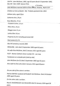
Document - Photocopies of family history and related government records, John McGlone family, 1829-1892
... ...Nunawading Farmers Common...Whitehorse Historical Society Inc. 2-10 Deep Creek Road Mitcham melbourne Government documents covering period 1829 to 1892, showing the family history of John and Eliza McGlone and their seven children 1829-1892 John McGlone Eliza McGlone nee O'Mara Nunawading Farmers Common Family history of John and Eliza McGlone and their seven children Photocopies (5) of documents from ancestry and Government and police gazette relating to the family of John and Eliza McGlone and their seven children John McGlone family Document Photocopies of family history and related government records ...Family history of John and Eliza McGlone and their seven childrenPhotocopies (5) of documents from ancestry and Government and police gazette relating to the family of John and Eliza McGlone and their seven childrennon-fictionFamily history of John and Eliza McGlone and their seven childrenjohn mcglone, eliza mcglone nee o'mara, nunawading farmers common -
 Ringwood and District Historical Society
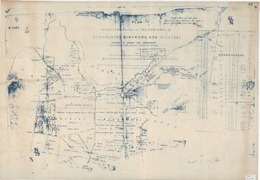
Map, Plan of Country Lands in the Parishes of Nunawading Ringwood and Scoresby - circa 1855
... Descriptive remarks include areas marked "Farmer's Common", "Poor soil thickly/moderately timbered with stringy bark", and location of water and firewood reserves. Plan of Country Lands in the Parishes of Nunawading Ringwood and Scoresby - circa 1855 Map ...Blueprint copy of Survey Map detailing original Selectors' names and property locations. List of Parish map references including property bearings, distances in Links, and markings on trees. Descriptive remarks include areas marked "Farmer's Common", "Poor soil thickly/moderately timbered with stringy bark", and location of water and firewood reserves."Surveyed and plotted by N.M. Bickford, Superintendant of Mr. Hodgkinson's Field Party". "The land comprised in this survey is of inferior quality, moderately undulating, and thickly wooded. It is watered by Dandenong Creek and Deep Creek." Inset map showing location of (*proposed) cemetery on southern corner of Lillydale Road from Melbourne and Sawmill Road, later Mount Dandenong Road. (*Cemetery did not eventuate.)