Showing 86 items matching "old stone house"
-
 Ballarat Heritage Services
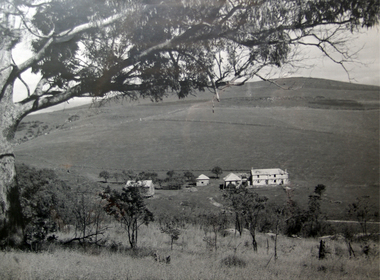
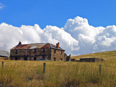
Photograph - Photograph - Black and White, The Old Stone House, Yandoit Creek
... The Old Stone House, Yandoit Creek...Gervasoni's 'old stone house' at Yandoit Creek, Victoria. The house was built by a partnership between Carlo Gervasoni, Luigi Gervasoni, Antonio Invernizzi and Battista Nani....Ballarat Heritage Services PO Box 2209 Bakery Hill Post Office goldfields stone house drystone gervasoni Invernizzi Nani Gervasoni's 'old stone house' at Yandoit Creek, Victoria. ...Gervasoni's 'old stone house' at Yandoit Creek, Victoria. The house was built by a partnership between Carlo Gervasoni, Luigi Gervasoni, Antonio Invernizzi and Battista Nani.stone house, drystone, gervasoni, invernizzi, nani -
 Ballarat Heritage Services
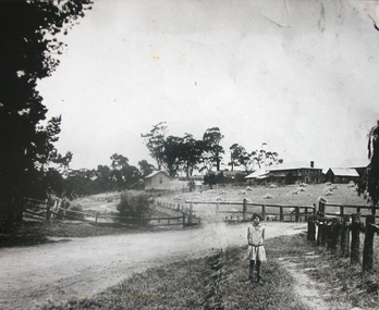
Photograph - Photograph - Black and White, Alice Gervasoni in front of the Old Stone House, Yandoit Creek
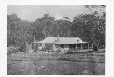
... Alice Gervasoni in front of the Old Stone House, Yandoit Creek...Alice Gervasoni stands in front of an old stone house in Yandoit Creek, in a paddock of stooked hay. ...Alice Gervasoni in front of the Old Stone House, Yandoit Creek Photograph Photograph - Black and White ...The Gervasoni farm at Yandoit Creek was selected in the 1860s by a coopertaive comprising Caro Gervasoni, Luigi Gervasoni, Ambrogio Invernizzi and Battista Nani.Alice Gervasoni stands in front of an old stone house in Yandoit Creek, in a paddock of stooked hay. The house was built by a partnership between Carlo Gervasoni, Luigi Gervasoni, Antonio Invernizzi and Battista Nani.alice gervasoni, luigi gervasoni, carlo gervasoni, battista nani, ambrogio invernizzi, hay, hay stook, stone house, drystone, farm, agriculture -
 Whitehorse Historical Society Inc.
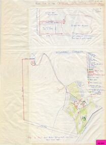
Map, Schwerkolt property and rough plan of old stone house, 1993
... Schwerkolt property and rough plan of old stone house...Schwerkolt property and rough plan of old stone house Map Map ...Map drawn by Arthur SchwerkoltMap drawn by Arthur Schwerkolt in 1993 from memory assisted by survey map of 1902. Covering letter from Glyn France [also at ND1367 (G-H-S-C 46) gives extra details.Map drawn by Arthur Schwerkoltschwerkolt cottage, schwerkolt, arthur, whalen, rosalie, france, glyn -
 Ballarat Heritage Services
Photograph - Digital photographs, L.J. Gervasoni, Gervasoni Homestead Yandoit Creek night, 2015
... ...Old Stone HOuse...Ballarat Heritage Services PO Box 2209 Bakery Hill Post Office goldfields http://vhd.heritagecouncil.vic.gov.au/places/69285 restoration heritage swiss italian gervasoni homestead family yandoit creek yandoit temporary shed permit exemption concrete slab Old Stone HOuse Gervasoni HOmestead Digital images of the Gervasoni homestead at Yandoit Creek. ...http://vhd.heritagecouncil.vic.gov.au/places/69285 Digital images of the Gervasoni homestead at Yandoit Creek.restoration, heritage, swiss italian, gervasoni, homestead, family, yandoit creek, yandoit, temporary, shed, permit exemption, concrete slab, old stone house, gervasoni homestead -
 Ballarat Heritage Services
Photograph - Digital photographs, L.J. Gervasoni, Gervasoni homestead, c2005
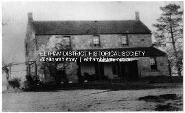
... ...OLd Stone house...Ballarat Heritage Services PO Box 2209 Bakery Hill Post Office goldfields gervasoni homestead swiss italian heritage yandoit creek Carlo Gervasoni Luigi Gervasoni Giuseppe Giapponi Ambrogio Invernizzi drystone OLd Stone house Colour photograph of a drystone building at Yandoit Creek built by Carlo Gervasoni, Luigi Gervasoni, Ambrogio Invernizzi and Giuseppe Giapponi Gervasoni homestead Photograph Digital photographs L.J. ...Colour photograph of a drystone building at Yandoit Creek built by Carlo Gervasoni, Luigi Gervasoni, Ambrogio Invernizzi and Giuseppe Giapponigervasoni homestead, swiss italian, heritage, yandoit creek, carlo gervasoni, luigi gervasoni, giuseppe giapponi, ambrogio invernizzi, drystone, old stone house -
 Linton and District Historical Society Inc
Photograph, St Enoch's and Mt Widderin, 1986, 1986
... Colour photograph of old stone house. Photograph taken on LDHS trip to St Enoch's and Mt Widderin, 1986....Colour photograph of old stone house. Photograph taken on LDHS trip to St Enoch's and Mt Widderin, 1986. ...Colour photograph of old stone house. Photograph taken on LDHS trip to St Enoch's and Mt Widderin, 1986."At St Enoch's / Society trip".st enoch's homestead, ldhs activities -
 Whitehorse Historical Society Inc.
Document - Correspondence, Letter and Map Schwerkolt houses, 9/11/1993
... Gray, Nunawading Historical Society from Glyn France enclosing map of Schwerkolt property and rough plan of old stone house drawn by Arthur Schwerkolt [map filed at A-SP 120]. ...Gray, Nunawading Historical Society from Glyn France enclosing map of Schwerkolt property and rough plan of old stone house drawn by Arthur Schwerkolt [map filed at A-SP 120]. ...Letter to W. Gray, Nunawading Historical Society from Glyn France enclosing map of Schwerkolt property and rough plan of old stone house drawn by Arthur Schwerkolt [map filed at A-SP 120]. Gives information about dates of building 'old' and 'new' houses.schwerkolt, arthur, schwerkolt, myra, france glyn, schwerkolt cottage -
Whitehorse Historical Society Inc.
Letter - Correspondence, Letter from Glynn France; poem, the old House; Xmas card from Mike Bates, 1993
... Also photocopy of a poem 'The Old Stone House' composed by Mike Bates....Also photocopy of a poem 'The Old Stone House' composed by Mike Bates. Letter from Glynn France; poem, the old House; Xmas card from Mike Bates. ...Letter to Nunawading Historical Society from Glyn France with details of Schwerkolt's Cottage with details of the rooms and various parts of the cottage. Also photocopy of a Xmas card sent to Charles Schwerkolt from Mike Bates who was renting the cottage in the late 1950s with a photo of the cottage at that time. Also photocopy of a poem 'The Old Stone House' composed by Mike Bates.schwerkolt cottage, bates, mike, schwerkolt, charles clarence viictor, whalen, rosalie, jackschowsky, mary elizabeth, schwerkolt, carl benno, france, glyn -
 Ballarat Heritage Services
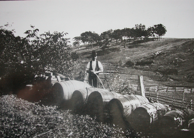
Photograph, Cleaning Wine Barrells at the Gervasoni Vineyard, Yandoit Creek
... He arrived in Australia in 1863 and was part of a co-operative to farm and build the old stone house at Yandoit Creek. Eventually moving to his own property he was a vigneron selling his wine in central Victoria and Melbourne, and exporting to Ireland. ...He arrived in Australia in 1863 and was part of a co-operative to farm and build the old stone house at Yandoit Creek. Eventually moving to his own property he was a vigneron selling his wine in central Victoria and Melbourne, and exporting to Ireland. ...Luigi Gervasoni was born in San Gallo, Lombardy, Italy. He arrived in Australia in 1863 and was part of a co-operative to farm and build the old stone house at Yandoit Creek. Eventually moving to his own property he was a vigneron selling his wine in central Victoria and Melbourne, and exporting to Ireland. Black and white photograph of wine barrells being cleaned at Yandoit Creek, Victoriayandoit creek, vineyard, barrell, gervasoni, swiss italian -
 Ballarat Heritage Services
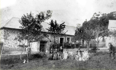
Photograph - Photograph - Black and White, Carlo Gervasoni and Family at Yandoit Creek, c1901
... Carlo Gervasoni and his family stand at the back of his Yandoit Creek house now known as ‘The Old Stone House’. L to R: Johanna Gervasoni, Annie Gervasoni (Carlo’s second wife), Annie Gervasoni with violin, Jim Neven, Theresa Gervasoni (standing), Nicol Gervasoni with cornet, Bridget Gervasoni, John Gervasoni with cornet, probably Battista Gervasoni, Carlo Gervasoni Jr (Cling) with accordion, Alf Kennett, Julia Gervasoni (standing). ...Ballarat Heritage Services PO Box 2209 Bakery Hill Post Office goldfields luigi gervasoni carlo gervasoni battista nani ambrogio invernizzi stone house drystone julia gervasoni cling gervasoni jim nevin annie gervasoni nichol gervasoni alf kennett bridget gervasoni Carlo Gervasoni and his family stand at the back of his Yandoit Creek house now known as ‘The Old Stone House’. ...Carlo Gervasoni and his family stand at the back of his Yandoit Creek house now known as ‘The Old Stone House’. L to R: Johanna Gervasoni, Annie Gervasoni (Carlo’s second wife), Annie Gervasoni with violin, Jim Neven, Theresa Gervasoni (standing), Nicol Gervasoni with cornet, Bridget Gervasoni, John Gervasoni with cornet, probably Battista Gervasoni, Carlo Gervasoni Jr (Cling) with accordion, Alf Kennett, Julia Gervasoni (standing). The house was built by a partnership between Carlo Gervasoni, Luigi Gervasoni, Antonio Invernizzi and Battista Nani.luigi gervasoni, carlo gervasoni, battista nani, ambrogio invernizzi, stone house, drystone, julia gervasoni, cling gervasoni, jim nevin, annie gervasoni, nichol gervasoni, alf kennett, bridget gervasoni -
 Ballarat Heritage Services
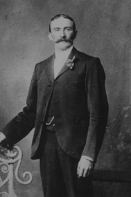
Photograph - Image - Black and White, Ambrogio Invernizzi, c1875, c1875
... They built the 'Old Stone House' at Yandoit Creek, that was later lived in by Carlo Gervasoni and his family. ...They built the 'Old Stone House' at Yandoit Creek, that was later lived in by Carlo Gervasoni and his family. ...Ambrogio Invernizzi Was from San Giovanni Bianco in Italy, and was an original partner with Carlo Gervasoni, Luigi Gervasoni and Giuseppe Giupponi. They built the 'Old Stone House' at Yandoit Creek, that was later lived in by Carlo Gervasoni and his family. Ambrogio and his family living in a neighbouring drystone house. Ambrogio Invernizzi died in 1888, aged 56 years. Ambrogio Invernizzi was born at San Giovanni Bianco, the neighbouring town to San Gallo, the birth town of the Gervasoni Brothers. Photograph portrait of Italian born Ambrogio Invernizzi of Yandoit Creek.ambrogio invernizzi, san giovanni bianco, yandoit creek, swiss italian -
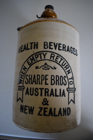 Warrnambool and District Historical Society Inc.
Demijohn (Sharpe Bros), Sharpe Bros, Early 20th century
... stone jars. The Warrnambool Sharpe Bros factory was established in 1919 and existed until 1951. It was situated at the old Rowley cordial factory at the corner of Banyan and Timor Streets. It was established by the founder of the Sharpe Bros business, John Sharpe. The signature on the base of the Warrnambool and District Historical Society Sharpe Bros jars is that of John H. Sharpe who for many years was the manager of the Sydney Sharpe Bros factories. He put the signature on the jars when he was visiting History House...stone jars. The Warrnambool Sharpe Bros factory was established in 1919 and existed until 1951. It was situated at the old Rowley cordial factory at the corner of Banyan and Timor Streets. It was established by the founder of the Sharpe Bros business, John Sharpe. The signature on the base of the Warrnambool and District Historical Society Sharpe Bros jars is that of John H. Sharpe who for many years was the manager of the Sydney Sharpe Bros factories. He put the signature on the jars when he was visiting History House ...This item is a Sharpe Bros stone jar, presumably from the Warrnambool factory. The Sharpe Bros soft drinks factories in Australia and New Zealand existed from 1903 to 1972 and at one stage they had 35 factories. They were best known for their home deliveries of ginger beer and other brewed beverages in one gallon stone jars. The Warrnambool Sharpe Bros factory was established in 1919 and existed until 1951. It was situated at the old Rowley cordial factory at the corner of Banyan and Timor Streets. It was established by the founder of the Sharpe Bros business, John Sharpe. The signature on the base of the Warrnambool and District Historical Society Sharpe Bros jars is that of John H. Sharpe who for many years was the manager of the Sydney Sharpe Bros factories. He put the signature on the jars when he was visiting History House in Warrnambool in the mid 1980s. This demijohn is of considerable importance as it comes from the Sharpe Bros aerated waters factory, a business that was prominent in Warrnambool for over 30 years. Cordial manufacturing was an important industry in Warrnambool for over 100 years.This is a cylindrical stone jar with a buff-coloured base, a light brown top and a composite material screw topper. The top above the neck is bulbous-shaped and above this it is dome-shaped. A metal handle is attached to the neck. The maker’s information is on the sides in black printing. Part of this information includes a horseshoe-shaped scroll and a decorative pattern. There is a signature and other writing on the base of the jar in blue ballpoint pen. Health Beverages When empty return to Sharpe Bros Australia & New Zealand Persons damaging, retaining or trading with this jar are liable to be prosecuted John H. Sharpe Jar made prior to 1914 sharpe bros soft drinks factory warrnambool, john h. sharpe, history of warrnambool -
 Bendigo Historical Society Inc.
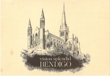
Book - VISION SPLENDID BENDIGO, 1986
... Vision Splendid Introduction, Wesleyan Church Golden Square, Sacred Heart Cathedral, Central Deborah Mine, Marlborough House, Fuse factory, Goldmines Hotel, Fortuna Villa, Bon Accord, Heinz Butcher Shop, Long Gully State School, California Gully State School, Stone cottage Harvey Town, Eaglehawk Town Hall, Caradon, Eaglehawk State School, Victoria Hotel, Bendigo Pottery, Eucalyptus Distillery, St Luke’s, Lake Weeroona, Joss House, Benevolent Home, Lansellstowe, Kaithness, Malmo Valentine Street, Dudley House, Rifle Brigade Hotel, Fire Station, Masonic Hall, Temperance Hall, Old Post Office, Wesley Church, St. ...Vision Splendid Introduction, Wesleyan Church Golden Square, Sacred Heart Cathedral, Central Deborah Mine, Marlborough House, Fuse factory, Goldmines Hotel, Fortuna Villa, Bon Accord, Heinz Butcher Shop, Long Gully State School, California Gully State School, Stone cottage Harvey Town, Eaglehawk Town Hall, Caradon, Eaglehawk State School, Victoria Hotel, Bendigo Pottery, Eucalyptus Distillery, St Luke’s, Lake Weeroona, Joss House, Benevolent Home, Lansellstowe, Kaithness, Malmo Valentine Street, Dudley House, Rifle Brigade Hotel, Fire Station, Masonic Hall, Temperance Hall, Old Post Office, Wesley Church, St. ...Vision Splendid Bendigo. Cream coloured paper 56 pages, with line drawings of landmark buildings of Bendigo. Drawings by Jan Neil. Vision Splendid Introduction, Wesleyan Church Golden Square, Sacred Heart Cathedral, Central Deborah Mine, Marlborough House, Fuse factory, Goldmines Hotel, Fortuna Villa, Bon Accord, Heinz Butcher Shop, Long Gully State School, California Gully State School, Stone cottage Harvey Town, Eaglehawk Town Hall, Caradon, Eaglehawk State School, Victoria Hotel, Bendigo Pottery, Eucalyptus Distillery, St Luke’s, Lake Weeroona, Joss House, Benevolent Home, Lansellstowe, Kaithness, Malmo Valentine Street, Dudley House, Rifle Brigade Hotel, Fire Station, Masonic Hall, Temperance Hall, Old Post Office, Wesley Church, St. John’s Church, Alexandra Fountain, Commercial Bank View Point, State Bank, St Paul’s Cathedral Railway Station, National Bank, Town Hall, Post Office, Shamrock Hotel, Camp Hill State School, Police Barracks, Law Courts, Specimen Cottage, Technical College, St. Kilian’s Church, Tram Depot, St. Aidan’s OrphanageJan Neilbendigo, buildings, heritage buildings, heritage, heritage buildings, bendigo. -
 Greensborough Historical Society
Photograph, Main Road bridge looking to township of Greensborough, 1929c
... Looking up Main Street we see the old Chapman house at the corner of Poulter Avenue and some newer houses below this. The stone river bridge appears to be only a single lane wide and the road approaching the bridge is unsealed. ...Looking up Main Street we see the old Chapman house at the corner of Poulter Avenue and some newer houses below this. The stone river bridge appears to be only a single lane wide and the road approaching the bridge is unsealed. ...View of Main Street Greensborough from Partington's Hill including Plenty River bridge and Marble Hall on corner of Carter Street (now Para Road) and Main Street. This view of Greensborough Park shows the old pan toilets, the hawthorn fence line and the rather undeveloped roadside area of the park. Looking up Main Street we see the old Chapman house at the corner of Poulter Avenue and some newer houses below this. The stone river bridge appears to be only a single lane wide and the road approaching the bridge is unsealed. The rail bridge shows evidence of soot from steam trains and at the extreme left of picture the two concrete buildings indicate the line had been electrified. This occurred in 1923. Sparse housing is seen in the Flintoff Street and Grimshaw Street area.Part of a collection of photographic enlargements of views of Greensborough in the early 1900s.Black and white enlargement of photographic imagemain street greensborough, marble hall, greensborough railway, chapman house, greensborough park, poulter avenue greensborough, carter street, para road -
 Halls Gap & Grampians Historical Society
Photograph - Coloured, C 1993
... Old Bake House, Halls Gap. 93" written in black pen on back of both copies. The photo shows a a large corrugated iron shed with a smaller lean-to entrance at the front. The shed is attached to a smaller stone ...The photo is of the Rob Greer's old bakery in Halls Gap. The copy is a close-up.The photo shows a a large corrugated iron shed with a smaller lean-to entrance at the front. The shed is attached to a smaller stone building (on the right of the photo). An old window is leaning against the front of the stone building and there is an old bench and pink wooden box with a hinged lid in the clearing at the front. Tall trees can be seen in the background."Rob Greer's, Old Bake House, Halls Gap. 93" written in black pen on back of both copies.buildings, bakery -
 Halls Gap & Grampians Historical Society
Photograph - Photocopy
... house with veranda. A chimney (stone?) protrudes from roof at front. cleared land in foreground with old style wooden fence visible. ...house with veranda. A chimney (stone?) protrudes from roof at front. cleared land in foreground with old style wooden fence visible. ...This house belonged to Walter Zumstein of the Zumsteins area. The house was burnt down in 1938. Photo was taken by Stan Parfett whose own family camped in the Zumstein area and knew Mr and Mrs Zumstein personally. c1920's This is an photocopied enlargement from a photocopied magazine article, Victoria's Heritage (see item 637)A house with veranda. A chimney (stone?) protrudes from roof at front. cleared land in foreground with old style wooden fence visible. A tank and stand situated beside house at front. Thick trees /Bush behind house.House Burnt 1938. Walter Zumstein's house. Photo by Stan Parfett. written on back.buildings, houses -
 Eltham District Historical Society Inc
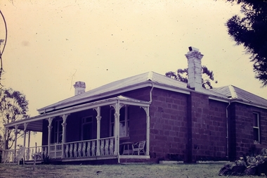
Photograph, "Pretty Hill", Kangaroo Ground. James Johnston's homestead
... stone house on his Pretty Hill property, Kangaroo Ground in 1842. It was one of the oldest homes in the district till 1938 when new owner Mr Percy Cope, a master builder demolished the old building and a new brick building was erected in its place. ...stone house on his Pretty Hill property, Kangaroo Ground in 1842. It was one of the oldest homes in the district till 1938 when new owner Mr Percy Cope, a master builder demolished the old building and a new brick building was erected in its place. ...Kangaroo Ground pioneers James Johnston (died 1895) with his wife Elizabeth commenced building this stone house on his Pretty Hill property, Kangaroo Ground in 1842. It was one of the oldest homes in the district till 1938 when new owner Mr Percy Cope, a master builder demolished the old building and a new brick building was erected in its place. Pretty Hill is one of the highest spots in the district with splendid views of the surrounding country.This photo forms part of a collection of photographs gathered by the Shire of Eltham for their centenary project book,"Pioneers and Painters: 100 years of the Shire of Eltham" by Alan Marshall (1971). The collection of over 500 images is held in partnership between Eltham District Historical Society and Yarra Plenty Regional Library (Eltham Library) and is now formally known as 'The Shire of Eltham Pioneers Photograph Collection'. It is significant in being the first community sourced collection representing the places and people of the Shire's first one hundred years.Digital imagesepp, shire of eltham pioneers photograph collection, kangaroo ground, pretty hill, stonen house, homestead, johnston family, james johnston -
 Eltham District Historical Society Inc
Photograph, Woodburn residence, mudbrick adobe (1949), Eltham Heritage Tour, 24 May 1992, 24/05/1992
... old windows. There's an air of past times about the School, the Dairy, the Butcher's (now a milk bar) and the Castlemaine stone face of the Commonwealth Bank. The final stop for the tour was at the mud-brick Woodburn residence, adobe of 1949 with additions. After War Service, Bill Woodburn had commenced an Architecture course at Melbourne University and after second year in the Christmas vacation, with his wife, Betti, built the two bedroom house - with amazing saving of costs. ...old windows. There's an air of past times about the School, the Dairy, the Butcher's (now a milk bar) and the Castlemaine stone face of the Commonwealth Bank. The final stop for the tour was at the mud-brick Woodburn residence, adobe of 1949 with additions. After War Service, Bill Woodburn had commenced an Architecture course at Melbourne University and after second year in the Christmas vacation, with his wife, Betti, built the two bedroom house - with amazing saving of costs. ...ELTHAM HERITAGE TOUR The Society excursion on 24th May 1992 was arranged by David Bick, leader of the team carrying out the Shire's heritage study. David selected a number of sites or buildings identified in the study, some of them lesser known components of the Shire's heritage. The tour commenced at the Eltham Shire Office at 10.00 am. Travel was by private car and mini-bus with stops at about twelve locations for commentary by David.It included a short walk in Hurstbridge and lunch at Kinglake. Highlights of the tour included: - 10 am Leave from Shire Offices - 3 Important Trees - A Physical Link to Eltham's First Settlers - Toorak Mansion Gates - A Surviving Farm House - An Intact Circa 1900 Main Street - First Settlers - Gold Miners, and Timber-getters - An Early Hotel - A Pioneering Homestead - Changing Eltham Shire - 20th Century - 4 pm Afternoon Tea and Finish Tour Extract from ELTHAM CULTURAL HERITAGE TOUR (Newsletter No. 85, July 1992, by Bettina Woodburn) "In some respects Eltham is a 'back-water' and it has its own distinctive flavour. On the outskirts the homes date from the 1960's, 70's and 80s with a sprinkling of 'earth homes', mud-brick or pise, rammed dirt. Crossing Main Road into Beddoe Street and Thompson Crescent a very pleasant drive past pines and old fence lines, front lawns unfenced, the occasional ·old farm building, we eventually looked down on a huge circular roof of a 1992 adobe home. Other distinctive places included the Pauline Toner Butterfly Reserve, Gordon Ford's splendid garden at Fulling in Pitt Street, cypress hedges and old houses in Bridge Street and in every direction Eltham's special feature - a totally treed horizon. We were now in the part of the Shire closest to Melbourne - Montmorency - not on the way to anywhere, with no through road going across it, developed in the 1950's and 1960's with conventional gardens, now converted to native plants. The rail looped between Greensborough and Eltham and a shopping street (Were Street) served the area, growing up the hill from the station. It was a typical outer Melbourne suburb with lawns and roses with patches of originality. The shopping precinct still has 1950 characteristics - walls which sloped back, projecting roofs, the original shop fronts are nearly all tiled below the old windows. There's an air of past times about the School, the Dairy, the Butcher's (now a milk bar) and the Castlemaine stone face of the Commonwealth Bank. The final stop for the tour was at the mud-brick Woodburn residence, adobe of 1949 with additions. After War Service, Bill Woodburn had commenced an Architecture course at Melbourne University and after second year in the Christmas vacation, with his wife, Betti, built the two bedroom house - with amazing saving of costs. In the three and a half months they made over 3000 bricks (external walls 18" x 12" x 4", internal walls 12" x 9" x 4"), sifted top soil for mortar and laid them, on concrete foundations and slab floor, made all the structural window frames, door frames and roof members to carry 'super six' asbestos sheets, laboured for the electrician and plumber, did all the glazing and, still without electricity, moved in in March 1949. Rooms have been added, at first with glass walls, later using concrete blocks, to accommodate three daughters and a son. The house not only grew from the earth, but also with the family."Record of the Society's history and activities and highlighting various aspects of the Heritage Study undertaken by David Bick used to create the future heritage overlay for the Shire of Eltham and later Nillumbik Shire.Roll of 35mm colour negative film, 4 stripsKodak Gold 100 5095shire of eltham historical society, activities, heritage tour, woodburn house -
 Eltham District Historical Society Inc
Photograph, Slab hut, Warrandyte, Warrandyte Mystery Tour, 29 May 1994, 29/05/1994
... Old Slab Hut in Castles Road. This remnant of miners' housing is preserved because it had been incorporated into a weatherboard house, and saved from the bulldozers - a last minute reprieve, for preservation, by the National Trust. Devastating bush fires have destroyed other old cottages built of wattle and daub, with bark roofs and stone...Old Slab Hut in Castles Road. This remnant of miners' housing is preserved because it had been incorporated into a weatherboard house, and saved from the bulldozers - a last minute reprieve, for preservation, by the National Trust. Devastating bush fires have destroyed other old cottages built of wattle and daub, with bark roofs and stone ...[article by Bettina Woodburn in EDHS Newsletter No. 97, July 1994:] THE WARRANDYTE MYSTERY TOUR MAY 29TH 1994 - Members of the Eltham Historical Society met at the Old Post Office, now converted into the Warrandyte Historical Museum, for a picnic lunch on the sunny back verandah overlooking the shimmering Yarra River. Interesting photographs and artefacts filled various rooms outlining the history of this area, and told tales of Aboriginal and more recent neighbours of the Eltham Shire. The weather was calm, cloudy mostly with only occasional sunny patches, but it wasn't cold, although the autumnal leaf colours had changed to wintry brown. "All Aboard" and we set off in the Warrandyte Community Bus (with the School Bus sign displayed at the rear) to learn about local places of "Pride and Joy” from Bruce our guide and Tom the driver. Almost directly opposite we entered Whipstick Gully to explore the first of the district's hidden treasures - the Victory, one of the largest of the six or so major mines, past the old quarry now used for abseiling practice. By torchlight we entered the rocky hillside and saw the seams of quartz the miners had followed in their search for gold. Stamping batteries, and there was one in this gully, converted discarded rock into 'road metal'. Warrandyte is proud to be the first declared Goldfield in 1851, and one of the longest surviving, into the 1920s. A pleasant drive across the Bridge and along Bradley's Lane to Norman's Reserve brought us to see another Tunnel at Pound Bend through which the Yarra was diverted to allow about three miles of river-bed to be used for prospecting for alluvial gold. Still on this side of the river we visited the Old Slab Hut in Castles Road. This remnant of miners' housing is preserved because it had been incorporated into a weatherboard house, and saved from the bulldozers - a last minute reprieve, for preservation, by the National Trust. Devastating bush fires have destroyed other old cottages built of wattle and daub, with bark roofs and stone fire-places. The Cairn commemorating the disclosure of Gold Discovery at Warrandyte on June 30th 1851 beside Anderson's Creek Road was our next point of historical interest. We drove on to South Warrandyte and circled back to above the ford on Anderson's Creek to the entrance of the 4th Hill Mine. Again we crept along with our torches, careful of the low roof-rock, and side shafts. At a junction in a large cavity we were able to stand, look up a long air-vent which some 'cavers' climb down, and marvel at, and experience an aspect of a miner's life. Outside we heard the same bird songs, the trills and bell-pealing, saw the same straggly eucalypts, and a silver leafed wattle in flower, native grasses and ferns, and the neat present day houses, often of Warrandyte stone, perhaps veneered only. The day ended pleasantly, seeing more of the Yarra from Everard Drive, and the water rushing out of the Tunnel at Pound Bend, before returning to afternoon tea or coffee at the Museum. A great day for all concerned - many thanks to the Organisers.Colour photographslab hut, warrandyte, "warrandyte miner's cottage" -
 Eltham District Historical Society Inc
Photograph, Pound Bend tunnel, Warrandyte, Warrandyte Mystery Tour, 29 May 1994, 29/05/1994
... Old Slab Hut in Castles Road. This remnant of miners' housing is preserved because it had been incorporated into a weatherboard house, and saved from the bulldozers - a last minute reprieve, for preservation, by the National Trust. Devastating bush fires have destroyed other old cottages built of wattle and daub, with bark roofs and stone...Old Slab Hut in Castles Road. This remnant of miners' housing is preserved because it had been incorporated into a weatherboard house, and saved from the bulldozers - a last minute reprieve, for preservation, by the National Trust. Devastating bush fires have destroyed other old cottages built of wattle and daub, with bark roofs and stone ...[article by Bettina Woodburn in EDHS Newsletter No. 97, July 1994:] THE WARRANDYTE MYSTERY TOUR MAY 29TH 1994 - Members of the Eltham Historical Society met at the Old Post Office, now converted into the Warrandyte Historical Museum, for a picnic lunch on the sunny back verandah overlooking the shimmering Yarra River. Interesting photographs and artefacts filled various rooms outlining the history of this area, and told tales of Aboriginal and more recent neighbours of the Eltham Shire. The weather was calm, cloudy mostly with only occasional sunny patches, but it wasn't cold, although the autumnal leaf colours had changed to wintry brown. "All Aboard" and we set off in the Warrandyte Community Bus (with the School Bus sign displayed at the rear) to learn about local places of "Pride and Joy” from Bruce our guide and Tom the driver. Almost directly opposite we entered Whipstick Gully to explore the first of the district's hidden treasures - the Victory, one of the largest of the six or so major mines, past the old quarry now used for abseiling practice. By torchlight we entered the rocky hillside and saw the seams of quartz the miners had followed in their search for gold. Stamping batteries, and there was one in this gully, converted discarded rock into 'road metal'. Warrandyte is proud to be the first declared Goldfield in 1851, and one of the longest surviving, into the 1920s. A pleasant drive across the Bridge and along Bradley's Lane to Norman's Reserve brought us to see another Tunnel at Pound Bend through which the Yarra was diverted to allow about three miles of river-bed to be used for prospecting for alluvial gold. Still on this side of the river we visited the Old Slab Hut in Castles Road. This remnant of miners' housing is preserved because it had been incorporated into a weatherboard house, and saved from the bulldozers - a last minute reprieve, for preservation, by the National Trust. Devastating bush fires have destroyed other old cottages built of wattle and daub, with bark roofs and stone fire-places. The Cairn commemorating the disclosure of Gold Discovery at Warrandyte on June 30th 1851 beside Anderson's Creek Road was our next point of historical interest. We drove on to South Warrandyte and circled back to above the ford on Anderson's Creek to the entrance of the 4th Hill Mine. Again we crept along with our torches, careful of the low roof-rock, and side shafts. At a junction in a large cavity we were able to stand, look up a long air-vent which some 'cavers' climb down, and marvel at, and experience an aspect of a miner's life. Outside we heard the same bird songs, the trills and bell-pealing, saw the same straggly eucalypts, and a silver leafed wattle in flower, native grasses and ferns, and the neat present day houses, often of Warrandyte stone, perhaps veneered only. The day ended pleasantly, seeing more of the Yarra from Everard Drive, and the water rushing out of the Tunnel at Pound Bend, before returning to afternoon tea or coffee at the Museum. A great day for all concerned - many thanks to the Organisers.Two colour photographswarrandyte, activities, pound bend -
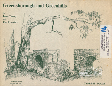 Eltham District Historical Society Inc
Book, Irene Turvey et al, Greensborough and Greenhills / words by Irene Turvey ; Drawings by Ron Reynolds, 1973
... Contents cover : Blue stone bridge, Introduction, House cnr Church and Hailes Street, House - 25 Hailes Street, Yandell Reserve, Greensborough Hotel, Lobb's Kiosk, House - 49 Grimshaw Street, View of Greensborough (from Delphin Crescent), Railway Station, Old Barn (near Greensborough Railway Station), Partington's Flat and River Valley, Rand Street Bridge, Lower Main Street, Greenbriar Nursery, Hitching rail, Ashmead - Dr Cordner's Home, Greensborough Primary School, House - cnr St Helena and Diamond Creek Raods, Sondermeyer's Hill, Methodist Church, Football Pavilion, Cemetery, St Katherine's Church, St. ...Contents cover : Blue stone bridge, Introduction, House cnr Church and Hailes Street, House - 25 Hailes Street, Yandell Reserve, Greensborough Hotel, Lobb's Kiosk, House - 49 Grimshaw Street, View of Greensborough (from Delphin Crescent), Railway Station, Old Barn (near Greensborough Railway Station), Partington's Flat and River Valley, Rand Street Bridge, Lower Main Street, Greenbriar Nursery, Hitching rail, Ashmead - Dr Cordner's Home, Greensborough Primary School, House - cnr St Helena and Diamond Creek Raods, Sondermeyer's Hill, Methodist Church, Football Pavilion, Cemetery, St Katherine's Church, St. ...Pen and ink sketches accompanied by appropriate text in double page spreads. Contents cover : Blue stone bridge, Introduction, House cnr Church and Hailes Street, House - 25 Hailes Street, Yandell Reserve, Greensborough Hotel, Lobb's Kiosk, House - 49 Grimshaw Street, View of Greensborough (from Delphin Crescent), Railway Station, Old Barn (near Greensborough Railway Station), Partington's Flat and River Valley, Rand Street Bridge, Lower Main Street, Greenbriar Nursery, Hitching rail, Ashmead - Dr Cordner's Home, Greensborough Primary School, House - cnr St Helena and Diamond Creek Raods, Sondermeyer's Hill, Methodist Church, Football Pavilion, Cemetery, St Katherine's Church, St. Helena, Civic Centre, Briar Hill Timber Mill, 24 River Street, Kelly's Garden Supplies, 158 Main Street, Old Swimming pool, 105 Main Street.Hardback; 62 p. : ill., map ; 19 x 25 cm.ISBN 0909807108 Signed by author and illustrator Two copiesgreenhills, greensborough -
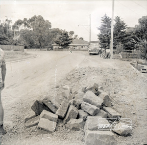 Eltham District Historical Society Inc
Photograph, Near 145 Mountainview Road, Briar Hill, early to mid 1960s, 1960s
... old motorcycle with side-car. These may have belonged to the Watson brothers (C.J. Watson’s sons) who undertook stone work for the Council. Work is under way at the house...old motorcycle with side-car. These may have belonged to the Watson brothers (C.J. Watson’s sons) who undertook stone work for the Council. Work is under way at the house ...Note the FX Holden ute with canopy and old motorcycle with side-car. These may have belonged to the Watson brothers (C.J. Watson’s sons) who undertook stone work for the Council. Work is under way at the house one down from the bend where two piles of bluestone are gathered; possibly for terrace edging of the driveway and footpath. These images were from a strip of negatives, most likely taken by a Shire of Eltham employee so the works could have been part of council operations. Many streets in the shire have stonework edges for gardens abutting footpaths where the roads have been cut into the terrain. Much of this stone masonry work was undertaken for the council by C.J. Watson and Sons.Roll of medium format 120 6x6 black and white negative film, 1 stripbriar hill, c.j. watson and sons, mountainview road, fx holden, side-car, motorcycles -
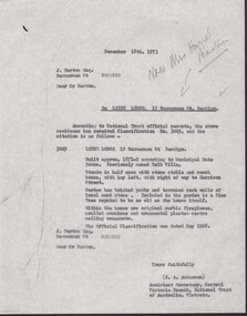 Bendigo Historical Society Inc.
Administrative record - National Trust Collection: Leigh Lodge, 12 Bannerman Street (formerly Selb Villa), 1973
... stone stable and coach house, with hay loft, with right of way to Harrison Street. Garden has bricked paths and terraced rock walls of local sand stone. Included in the garden is a Pine Tree reputed to be as old...stone stable and coach house, with hay loft, with right of way to Harrison Street. Garden has bricked paths and terraced rock walls of local sand stone. Included in the garden is a Pine Tree reputed to be as old ...Leigh Lodge (formerly Selb Villa) Bendigo, 12 Bannerman St. Bendigo.National Trust Collection: Leigh Lodge, 12 Bannerman Street, Bendigo 3222 A - 15 December 1973, letter from Central Victoria Branch National Trust of Australia, Victoria to J. Barton Esq. that the property at 12 Bannerman Street has received Classification No. 3049, which states: LEIGH LODGE 12 Bannerman St Bendigo. Built approx. 1871-2 according to Municipal Rate Books. Previously named Selb Villa. Stands in half acre with stone stable and coach house, with hay loft, with right of way to Harrison Street. Garden has bricked paths and terraced rock walls of local sand stone. Included in the garden is a Pine Tree reputed to be as old as the house itself. Within the house are original marble fireplaces, moulded cornices and ornamental plaster centre ceiling ornaments. The official Classification was dated May 1968. 3222 B - copy of the classification of Leigh Lodge (as Above), on yellow paper, and handwritten comments. 3222 B handwritten comments on the undated copy of the NT classificationhistoric building -
 Bendigo Historical Society Inc.
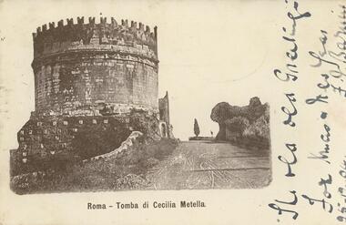
Postcard - ROY AND DORIS KELLY COLLECTION: TOMBA DI CECILIA METELLA, 1900-1920
... History House 11 Mackenzie Street Bendigo goldfields POSTCARD Postcard Rome Tomb Freddie Binks Postcard, Sepia photo of the Tomb of Cecilia Metella just outside Rome on the Via Appia. A round stone tower beside the road with a pine tree in the distance. Handwritten in ink beside the picture 'The old ...Postcard, Sepia photo of the Tomb of Cecilia Metella just outside Rome on the Via Appia. A round stone tower beside the road with a pine tree in the distance. Handwritten in ink beside the picture 'The old old Greetings For Xmas & New Year 25-12-04' Signature not decipherable. Addressee on the back 'Freddie Binks National Bank Bendigo' Green halfpenny Victoria stamp with cancellation dated 27.12.04postcard, postcard, rome, tomb, freddie binks -
 Bendigo Historical Society Inc.
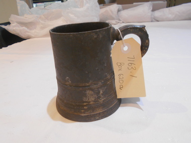
Domestic Object - PEWTER MUG FROM 'GLASGOW ARMS' HOTEL
... House 11 Mackenzie Street Bendigo goldfields BENDIGO Hotel Glasgow Arms Pewter mug, recovered by David Gunn from the Glasgow Arms Hotel, Kangaroo Flat. The Gunn family held the license in the early days of the hotel. Mug has an ornate handle and glass bottom. Piece of paper insider mug ' Pewter mug - recovered by David Gunn from the old Gunn Hotel 'The Glasgow Arms' at Kangaroo Flat. I became very friendly with Dave and his wife Nolly. Our Binks connection with Gunn famiy was by Aunt Sara Fraser' Signed Q,C, Binks C 1985. SEE ALSO Glasgow Arms Hotel foundation stone ...Pewter mug, recovered by David Gunn from the Glasgow Arms Hotel, Kangaroo Flat. The Gunn family held the license in the early days of the hotel. Mug has an ornate handle and glass bottom. Piece of paper insider mug ' Pewter mug - recovered by David Gunn from the old Gunn Hotel 'The Glasgow Arms' at Kangaroo Flat. I became very friendly with Dave and his wife Nolly. Our Binks connection with Gunn famiy was by Aunt Sara Fraser' Signed Q,C, Binks C 1985. SEE ALSO Glasgow Arms Hotel foundation stone (7163)bendigo, hotel, glasgow arms -
 Bendigo Historical Society Inc.
Document - ALBERT RICHARDSON COLLECTION: CARLISLE UNITED MINE GARDEN GULLY LINE
... And the old Carlisle and North Garden only recently being unearthed beneath the Unity, 'Carlisle' sand heap.' Details about the mining plant, the main shaft, the winding engine air compressor, stone crusher, and engine house are given. ...And the old Carlisle and North Garden only recently being unearthed beneath the Unity, 'Carlisle' sand heap.' Details about the mining plant, the main shaft, the winding engine air compressor, stone crusher, and engine house are given. ...Eight page handwritten document with details of the Carlisle United Gold Mine at Long Gully. The lease was 76 acres, 660 yards on line of reef. The Kent shaft was the next mine north Havilah Road, Boldt Street's corner. 'The Carlisle United was formed by the amalgamation of ttte companies, the Old Carlisle, the North Garden and the Passby. These mines were situated on the west side of Bennett Street in about a length of a few hundred feet, with the Passby on the Casley Street corner. And the old Carlisle and North Garden only recently being unearthed beneath the Unity, 'Carlisle' sand heap.' Details about the mining plant, the main shaft, the winding engine air compressor, stone crusher, and engine house are given. The Kent shaft and steel poppet legs are described. Four early claims on the Carlisle United ground are listed: Morgan, Kirshner and Co., Boyd and Co. Claim, Shanks and Co's claim and Day and Co's claim.bendigo, mining, carlisle united -
 Bendigo Historical Society Inc.
Slide - Adelaide Vale Homestead Fosterville
... house. This is an interesting homestead dating from early times and constructed of local stone. The front facade is typically composed and the plan reflects the continuous growth of the property throughout the nineteenth century. The octagonal pavillion is a significant and unusual feature. The homestead is picturesquely sited and overlooks the Campaspe River valley, the Burke and Wills expedition camped nearby on their ill-fated expedition north. The old...house. This is an interesting homestead dating from early times and constructed of local stone. The front facade is typically composed and the plan reflects the continuous growth of the property throughout the nineteenth century. The octagonal pavillion is a significant and unusual feature. The homestead is picturesquely sited and overlooks the Campaspe River valley, the Burke and Wills expedition camped nearby on their ill-fated expedition north. The old ...Adelaide Vale Homestead was begun in 1853 by John Harvey and was later occupied by Edward and Andrew O'Keefe. The building comprises a series of single storey stone buildings arranged behind a simple composed, verandah facade with a centrally located doorway flanked by windows. A central corridor leads from this doorway to a transverse corridor which was probably once an open breezeway. A free- standing octagonal pavilion is located close to the house. This is an interesting homestead dating from early times and constructed of local stone. The front facade is typically composed and the plan reflects the continuous growth of the property throughout the nineteenth century. The octagonal pavillion is a significant and unusual feature. The homestead is picturesquely sited and overlooks the Campaspe River valley, the Burke and Wills expedition camped nearby on their ill-fated expedition north. The old cheese factory is the sole survivor of the once extensive out-buildings. Some of the nineteenth century buildings have been demolished and there have been some later additions and alterations, notably an extensive side wing added in the 1920's. [In Butcher & Flanders, Bendigo Historic Buildings, 1987, the date of the house is given as 1868. Presumably this house replaced an older one on the property.]Adelaide Vale Homestead Fostervillehistory, bendigo, national trust collection bendigo, adelaide vale homestead -
 Bendigo Historical Society Inc.
Photograph - PHOTO OF STONE STAIRCASE
... History House 11 Mackenzie Street Bendigo goldfields BUILDINGS Government bendigo post office Photograph showing stairs at the Old Police Barrack looking toward the Post Office clock tower. Photo showing a staircase located at the Old Police Barrack on the hill in Rosalind park looking toward and showing the Clock Tower towering above the Former post Office building. Photograph PHOTO OF STONE ...Photo showing a staircase located at the Old Police Barrack on the hill in Rosalind park looking toward and showing the Clock Tower towering above the Former post Office building.buildings, government, bendigo post office, photograph showing stairs at the old police barrack looking toward the post office clock tower. -
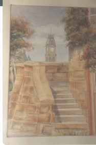
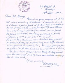 Bendigo Historical Society Inc.
Document - LETTER: DESCRIBING THE OLD STONE CHURCH OF ST. KILIAN, 19/09/1959
... History House 11 Mackenzie Street Bendigo goldfields CHURCH History st. kilian's catholic church bendigo D H Hogan Letter describing the old stone church of St. ...Letter describing the old stone church of St. Kilian. From D H Hogan, 67 Chapel St to a Mr Harry (dated 19/9/1959). Writer of the letter was a junior pupil at the boy's School in 1887 and attended mass at the old stone church. Writer describes the position of the church in relation to present church and orientation of the sanctuary (and gallery at the opposite end). Letter is stamped with the RHSV Bendigo Branch stamp, 1959.D H Hoganchurch, history, st. kilian's catholic church, bendigo -
 Bendigo Historical Society Inc.
Photograph - CASTLEMAINE GAS COMPANY COLLECTION: PHOTO TREE LINED STREET
... History House 11 Mackenzie Street Bendigo goldfields PLACE Streetscape unknown Agfa Photo of a tree lined street, on the left a 2 story brick building on the right a blue stones building, that has been described as an old flour mill, located in Kyneton Victoria. ...Photo of a tree lined street, on the left a 2 story brick building on the right a blue stones building, that has been described as an old flour mill, located in Kyneton Victoria. At the corner of Piper and Ebden Streets.Agfaplace, streetscape, unknown