Showing 313 items matching "original survey"
-
 Clunes Museum
Equipment - SURVEY MARKER
... ORIGINAL SURVEY MARKER. MOUNT CAMERON. ROUND MARKER WITH A STEM WHICH IS BROKEN. ...WORDING ON CARDBOARD "ORIGINAL SURVEY MARKER MOUNT CAMERON"...SURVEY MARKER MOUNT CAMERON SURVEYING WORDING ON CARDBOARD "ORIGINAL SURVEY MARKER MOUNT CAMERON" ORIGINAL SURVEY MARKER. ...ORIGINAL SURVEY MARKER. MOUNT CAMERON. ROUND MARKER WITH A STEM WHICH IS BROKEN. ON HEAD OF MARKER: SURVEY MARK 1. PENALTY L50 FOR INTERFERENCE. MOUNTED ONTO CARDBOARDWORDING ON CARDBOARD "ORIGINAL SURVEY MARKER MOUNT CAMERON"survey marker, mount cameron, surveying -
 Bendigo Historical Society Inc.
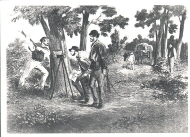
Photograph - WES HARRY COLLECTION: SURVEY PARTY, 1854
... ...original survey...ORGANIZATION Lands and survey original survey Surveying Theodilite Chain Photograph of a drawing depicting a survey party in 1854. ...Photograph of a drawing depicting a survey party in 1854. In the left foreground there are Two men, one is looking through a theodolite, and another is blazing a mark on to a tree with an axe. Two other men are dragging a chain measure. In the background there is a boy standing by a horse and cart. The whole group is in a bush land setting.organization, lands and survey, original survey, surveying, theodilite, chain -
Whitehorse Historical Society Inc.
Map, Subdivision of Allotment 122a, 1972
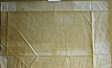
... Original survey Rob Poole 1899. Stamp indicates 'Land on this plan is in proclaimed survey No 21. ...Subdivision of land along Livermore Close and Moore Road, Vermont South. Original survey Rob Poole 1899. Stamp indicates 'Land on this plan is in proclaimed survey No 21. ...Whitehorse Historical Society Inc. 2-10 Deep Creek Road Mitcham melbourne Original survey Rob Poole 1899. Stamp indicates 'Land on this plan is in proclaimed survey No 21. ...Subdivision of land along Livermore Close and Moore Road, Vermont South.Subdivision of land along Livermore Close and Moore Road, Vermont South. Original survey Rob Poole 1899. Stamp indicates 'Land on this plan is in proclaimed survey No 21. Survey Coordination Act 1940. As from 9 Aug 1972. Two maps in different scales.Subdivision of land along Livermore Close and Moore Road, Vermont South. land subdivision, livermore close, vermont south, moore road, vermont south, dandenong creek -
Whitehorse Historical Society Inc.
Map, Parish of Nunawading, 1927
... Roads, railway and stations marked. Original survey by W.J.Busocon, 1915. Manuscript note: 15.2.1927 Verified Dept. ...Roads, railway and stations marked. Original survey by W.J.Busocon, 1915. Manuscript note: 15.2.1927 Verified Dept. ...Roads, railway and stations marked. Original survey by W.J.Busocon, 1915. Manuscript note: 15.2.1927 Verified Dept. ...Map of the Parish together with part of the Borough of Box Hill.Map of the Parish together with part of the Borough of Box Hill. Includes names of lease or license holders, sizes of leases and in some areas dates of leases. Roads, railway and stations marked. Original survey by W.J.Busocon, 1915. Manuscript note: 15.2.1927 Verified Dept. Lands and Survey.Map of the Parish together with part of the Borough of Box Hill. maps, parish of nunawading, borough of box hill -
 Orbost & District Historical Society
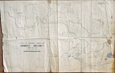
survey, 26th July 1950
... A copy of the original survey of Orbost District 1870. White background with black print. ...Orbost & District Historical Society Ruskin Street Orbost gippsland This map is a research tool for identifying historical land records in Orbost. map survey-Orbost some pen marks A copy of the original survey of Orbost District 1870. White background with black print. ...This map is a research tool for identifying historical land records in Orbost.A copy of the original survey of Orbost District 1870. White background with black print. The original was hand-drawn in ink. This is PLATE 1.some pen marksmap survey-orbost -
 Bendigo Historical Society Inc.
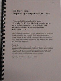
Book - SANDHURST MAPS, 1870s
... Enlarged from original survey Field Book. Prepared by Carol Holsworth December 2011...Enlarged from original survey Field Book. Prepared by Carol Holsworth December 2011 Book SANDHURST MAPS ...Sandhurst Maps Prepared by George Black Surveyor. Enlarged from original survey Field Book. Prepared by Carol Holsworth December 2011george black, sandhurst maps, 1870 -
Whitehorse Historical Society Inc.
Map, Yarra River, n.d
... Based on T.H. Nutt's original survey of the Yarra River, 1839....Based on T.H. Nutt's original survey of the Yarra River, 1839. Yarra River Map Map ...Copy of fold-out map 'Loddon 25' included in 'Lilydale', by Grace Aveling. Based on T.H. Nutt's original survey of the Yarra River, 1839.aveling, grace, nutt, t.h., yarra river -
Whitehorse Historical Society Inc.
Map, Yarra River, 1839
... Copy of T.H. Nott's original survey of 'Yarra Yarra River' taken from 'Lilydale' by Grace Aveling. ...Copy of T.H. Nott's original survey of 'Yarra Yarra River' taken from 'Lilydale' by Grace Aveling. ...Copy of T.H. Nott's original survey of 'Yarra Yarra River' taken from 'Lilydale' by Grace Aveling.Copy of T.H. Nott's original survey of 'Yarra Yarra River' taken from 'Lilydale' by Grace Aveling. Covers area from Templestowe to Yarra Glen.Copy of T.H. Nott's original survey of 'Yarra Yarra River' taken from 'Lilydale' by Grace Aveling. maps, yarra river -
 Ringwood and District Historical Society
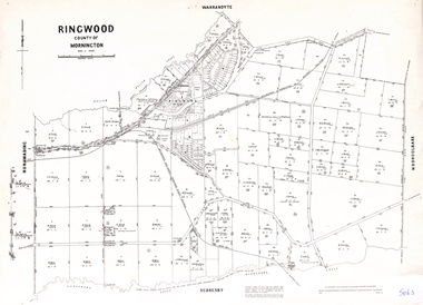
Map - Parish of Ringwood, County of Mornington, Victoria, Original Land Owners
... Laminated Parish map of Ringwood detailing original Land Owners' names, property locations and acreages. Details reproduced in 1957 by the Department of Lands and Survey, Melbourne, from original surveys of varying dates....Ringwood and District Historical Society 125A Warrandyte Road Ringwood North melbourne Laminated Parish map of Ringwood detailing original Land Owners' names, property locations and acreages. Details reproduced in 1957 by the Department of Lands and Survey, Melbourne, from original surveys of varying dates. ...Laminated Parish map of Ringwood detailing original Land Owners' names, property locations and acreages. Details reproduced in 1957 by the Department of Lands and Survey, Melbourne, from original surveys of varying dates. -
 Orbost & District Historical Society
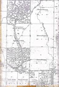
survey sheet, circa 1870's
... This is a copy of the original survey. It shows the properties of W.J.T. ...This is a copy of the original survey. It shows the properties of W.J.T. ...E.L. Bruce, born in Ireland on July 1,1854, came to Australia in 1854 and joined the Lands Department. He spent most of his service in Gippsland. The journey to Sale then was made by ship to Port Albert and thence on horseback. He began his service in Gippsland as assistant district surveyor and for the last 12 years before retirement he was district surveyor and land officer. His territory extended from the boundary of Victoria in east Gippsland down to Wilson's Promontory with his headquarters at sale.This map is a useful reference tool.A survey map - Sheet No 3 SnowyRiver Survey. This is a copy of the original survey. It shows the properties of W.J.T. Clarke - two in Orbost and one in Newmeralla (sic),. it has a faded, undecipherable red stamp in the bottom right corner.Gipps Land Rivers No 32B E.L. Brucesurvey bruce-e.l snowy-river-c19th -
 Greensborough Historical Society
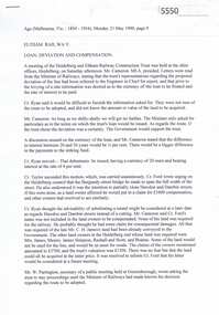
Newspaper Clipping, Eltham Railway: loan, deviation and compensation, 21/05/1900
... Relates to the disagreement between advocates of the original surveyed route and the proposed "deviation" for the Heidelberg to Eltham railway extension, 1900....Greensborough Historical Society 34A Glenauburn Road Lower Plenty Lower Plenty melbourne Relates to the disagreement between advocates of the original surveyed route and the proposed "deviation" for the Heidelberg to Eltham railway extension, 1900. railways hurstbridge rail line 6 p. transcripts of newspaper reports from the Age 21/05/1900 and Mercury and Weekly Courier 13/07/1900 regarding discussions on the route to be taken by the Heidelberg to Eltham railway extension Eltham Railway: loan, deviation and compensation Newspaper Clipping The Age Mercury and Weekly Courier ...Relates to the disagreement between advocates of the original surveyed route and the proposed "deviation" for the Heidelberg to Eltham railway extension, 1900.6 p. transcripts of newspaper reports from the Age 21/05/1900 and Mercury and Weekly Courier 13/07/1900 regarding discussions on the route to be taken by the Heidelberg to Eltham railway extensionrailways, hurstbridge rail line -
 Rutherglen Historical Society
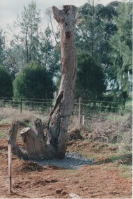
Image, Survey Tree, Jacks Road
... Original blazed survey tree was removed and then replaced by Gas Workers...Rutherglen Historical Society Murray Street Rutherglen high-country Original blazed survey tree was removed and then replaced by Gas Workers tree survey reference marks blazed tree jacks road Survey marks on tree blaze Colour photograph of the remains of a survey tree, concreted into the ground Survey Tree, Jacks Road Image ...Original blazed survey tree was removed and then replaced by Gas WorkersColour photograph of the remains of a survey tree, concreted into the groundSurvey marks on tree blazetree, survey reference marks, blazed tree, jacks road -
 Rutherglen Historical Society
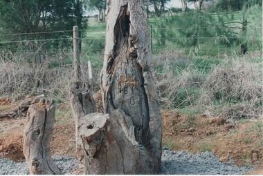
Image, Survey Tree, Jacks Road
... Original blazed survey tree was removed and then replaced by Gas Workers...Rutherglen Historical Society Murray Street Rutherglen high-country Original blazed survey tree was removed and then replaced by Gas Workers tree survey reference marks blazed tree jacks road Survey marks on tree blaze Colour photograph of the remains of a survey tree, concreted into the ground. ...Original blazed survey tree was removed and then replaced by Gas WorkersColour photograph of the remains of a survey tree, concreted into the ground. This photo is a close-up to better show the survey marks.Survey marks on tree blazetree, survey reference marks, blazed tree, jacks road -
 Bendigo Military Museum
Artwork, other - RASvy Corps Badges - Combined circa 1990s, Army Svy Regt, Circa 1990
... Left to right in positive format on clear film the badges are - the original Survey Corps badge pre1948. Centre item is the 2nd AIF colour patch. ...Left to right in positive format on clear film the badges are - the original Survey Corps badge pre1948. Centre item is the 2nd AIF colour patch. ...Left to right in positive format on clear film the badges are - the original Survey Corps badge pre1948. Centre item is the 2nd AIF colour patch. On the actual patch the border is grey, the triangles are purple and the central bar is white. The badge on the right was adopted when the title "Royal" was granted in Dec 1948A4 size clear film with the three RA Svy Corps badges superimposed. rasvy, fortuna, army svy regt, royal australian survey corps, army survey regiment -
 Ringwood and District Historical Society
Map, Partial Extract of Department of Lands and Survey Map, County of Mornington - 1955
... Two sections of original Crown Portions survey map of Ringwood and Mooroolbark separated along fold lines. ...Ringwood and District Historical Society 125A Warrandyte Road Ringwood North melbourne Two sections of original Crown Portions survey map of Ringwood and Mooroolbark separated along fold lines. ...Two sections of original Crown Portions survey map of Ringwood and Mooroolbark separated along fold lines. -
 Lakes Entrance Historical Society
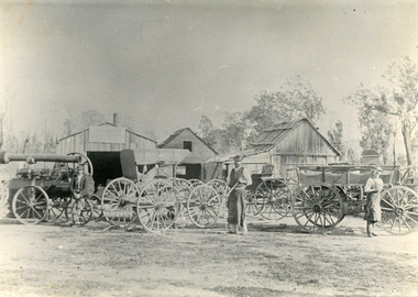
Photograph - Harry Froud's coach factory, P Hancock, 1900 c
... Henry Froud's Blacksmith Coach Building and Wheelwright's business set up at original surveyed site west of present township, nearer to cemetery turnoff,. ...Lakes Entrance Historical Society 4 Marine Parade Lakes Entrance gippsland Henry Froud's Blacksmith Coach Building and Wheelwright's business set up at original surveyed site west of present township, nearer to cemetery turnoff,. ...Henry Froud's Blacksmith Coach Building and Wheelwright's business set up at original surveyed site west of present township, nearer to cemetery turnoff,. Business first moved to corner of Princes Highway and Bruthen Road, (now site of Black Stump Store), then moved to premises built by Harry Froud on south side of highway, corner of Punt Road, (present site of BP Garage).Black and white photograph of Harry Frouds first coach factory west of present township, showing three men in front of four wheeled vehicles including a steam engine. Three workshops in background, two having bark roofs, man in centre identified as Harry Froud, William Henry. Johnsonville Victoria. transport, factory, people, local history -
Bendigo Historical Society Inc.
Map - YALLOOK : COUNTY OF BENDIGO, 1957
... Distances shown on the plan are derived from original surveys of varying dates and whilst approximately correct do not necessarily conform to modern standards of accuracy. ...Distances shown on the plan are derived from original surveys of varying dates and whilst approximately correct do not necessarily conform to modern standards of accuracy. ...Map. Yallook, County of Bendigo, Talambe, Neilborough, Yarraberb, Salisbury, Pompapiel. Drawn and reproduced at the Department of Lands and Survey, Melbourne,1957. Distances shown on the plan are derived from original surveys of varying dates and whilst approximately correct do not necessarily conform to modern standards of accuracy. For survey information application should be made to the central plan office, or to the office of titles. Some ink scibbles appear at the right top of this map. Price 2/-. (number 14 in map cupboard 1)By Authority W.M.Houston, Govt.Printer,Melbourne.map, bendigo, yallook -
 Peterborough History Group
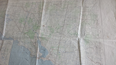
Map - Government map, Government Printer, Port campbell, 1957
... Original 1957 State Aerial Survey Map of Port Campbell region, including Peterborough...Significant because it shows the detail of the region in 1957 peterborough aerial survey map maps Port Campell Original 1957 State Aerial Survey Map of Port Campbell region, including Peterborough Port campbell Map Government map Government Printer ...Aerial survey map showing roads, vegetation and other landscape features.Significant because it shows the detail of the region in 1957Original 1957 State Aerial Survey Map of Port Campbell region, including Peterboroughpeterborough, aerial survey map, maps, port campell -
 Orbost & District Historical Society
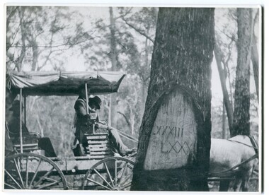
black and white photograph, 1913
... This photograph shows the reference tree, 83 miles from Marlo via the original surveyed road v ia Sydenham Inlet and Tamboon, south of Mount Drummer to the New South Wales border - now the Princes Highway....This photograph shows the reference tree, 83 miles from Marlo via the original surveyed road v ia Sydenham Inlet and Tamboon, south of Mount Drummer to the New South Wales border - now the Princes Highway. ...When marking a boundary for a registered plan, a surveyor would place “Reference Marks” with a stated bearing and distance to a boundary corner. These trees were typically marked by cutting the bark of the tree in a shield or blaze. Until July 1886, surveyors were only able to use trees as reference marks to boundary corners. After July 1886 surveyors were able to use “permanent marks” which were either a glass bottle, gas pipe or iron bolt (for homestead surveys only). This photograph shows the reference tree, 83 miles from Marlo via the original surveyed road v ia Sydenham Inlet and Tamboon, south of Mount Drummer to the New South Wales border - now the Princes Highway.This is a pictorial record of an old survet tree. Knowledge of their location, abundance and condition not only provide important insights to past survey practice, but also provide a lasting legacy of a regions land-use history. Old survey trees serve as one of the few remaining physical legacies of early European land settlement history.A large black / white photograph of a horse and buggy pulled up alongside a reference tree which has notches and markings of Roman numerals.on back - " Refernce tree 83 miles from Marlo........to N.S.W. Border"survey-tree reference-tree -
 Kew Historical Society Inc
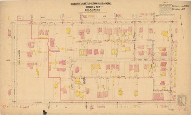
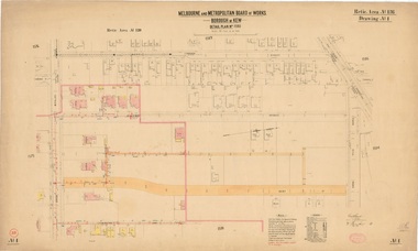
Plan, Melbourne & Metropolitan Board of Works : Borough of Kew : Detail Plan No.1592, 1905
... Original survey plan, issued by the MMBW to a contractor with responsibility for constructing sewers in the area identified on the plan within the Borough of Kew. ...A number of the plans are not held in the collection of the State Library of Victoria so they have the additional attribute of rarity. melbourne and metropolitan board of works, detail plans survey plans - borough of kew mmbw 1592 cartography Original survey plan, issued by the MMBW to a contractor with responsibility for constructing sewers in the area identified on the plan within the Borough of Kew. ...The Melbourne and Metropolitan Board of Works (MMBW) plans were produced from the 1890s to the 1950s. They were crucial to the design and development of Melbourne's sewerage and drainage system. The plans, at a scale of 40 feet to 1 inch (1:480), provide a detailed historical record of Melbourne streetscapes and environmental features. Each plan covers one or two street blocks (roughly six streets), showing details of buildings, including garden layouts and ownership boundaries, and features such as laneways, drains, bridges, parks, municipal boundaries and other prominent landmarks as they existed at the time each plan was produced. (Source: State Library of Victoria). This plan forms part of a large group of MMBW plans and maps that was donated to the Society by the Mr Poulter, City Engineer of the City of Kew in 1989. Within this collection, thirty-five hand-coloured plans, backed with linen, are of statewide significance as they include annotations that provide details of construction materials used in buildings in the first decade of the 20th century as well as additional information about land ownership and usage. The copies in the Public Record Office Victoria and the State Library of Victoria are monochrome versions which do not denote building materials so that the maps in this collection are invaluable and unique tools for researchers and heritage consultants. A number of the plans are not held in the collection of the State Library of Victoria so they have the additional attribute of rarity.Original survey plan, issued by the MMBW to a contractor with responsibility for constructing sewers in the area identified on the plan within the Borough of Kew. The plan was at some stage hand-coloured, possibly by the contractor, but more likely by officers working in the Engineering Department of the Borough and later Town, then City of Kew. The hand-coloured sections of buildings on the plan were used to denote masonry or brick constructions (pink), weatherboard constructions (yellow), and public buildings (grey). In MMBW Plan No.1592, the pink line indicates that area of the plan for which the contracting engineer was responsible. Included in the Plan are a number of primarily brick villas in a section of Belmont Avenue off Cotham Road. The house ‘Uvadale’ north of Belmont Avenue, and facing Cotham Road is also included in the contract. Excluded from the contract but shown on the Plan are ‘Glendonald’, ‘Mont Belmont’ and ‘Gilden’.melbourne and metropolitan board of works, detail plans, survey plans - borough of kew, mmbw 1592, cartography -
 Kew Historical Society Inc
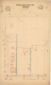
Plan, Melbourne & Metropolitan Board of Works : Borough of Kew : Detail Plan No.1561, 1905
... Original survey plan, issued by the MMBW to a contractor with responsibility for constructing sewers in the area identified on the plan within the Borough of Kew. ...A number of the plans are not held in the collection of the State Library of Victoria so they have the additional attribute of rarity. melbourne and metropolitan board of works, detail plans mmbw 1561 cartography Original survey plan, issued by the MMBW to a contractor with responsibility for constructing sewers in the area identified on the plan within the Borough of Kew. ...The Melbourne and Metropolitan Board of Works (MMBW) plans were produced from the 1890s to the 1950s. They were crucial to the design and development of Melbourne's sewerage and drainage system. The plans, at a scale of 40 feet to 1 inch (1:480), provide a detailed historical record of Melbourne streetscapes and environmental features. Each plan covers one or two street blocks (roughly six streets), showing details of buildings, including garden layouts and ownership boundaries, and features such as laneways, drains, bridges, parks, municipal boundaries and other prominent landmarks as they existed at the time each plan was produced. (Source: State Library of Victoria). This plan forms part of a large group of MMBW plans and maps that was donated to the Society by Mr Poulter, City Engineer of the City of Kew in 1989. Within this collection, thirty-five hand-coloured plans, backed with linen, are of statewide significance as they include annotations that provide details of construction materials used in buildings in the first decade of the 20th century as well as additional information about land ownership and usage. The copies in the Public Record Office Victoria and the State Library of Victoria are monochrome versions which do not denote building materials so that the maps in this collection are invaluable and unique tools for researchers and heritage consultants. A number of the plans are not held in the collection of the State Library of Victoria so they have the additional attribute of rarity.Original survey plan, issued by the MMBW to a contractor with responsibility for constructing sewers in the area identified on the plan within the Borough of Kew. The plan was at some stage hand-coloured, possibly by the contractor, but more likely by officers working in the Engineering Department of the Borough and later Town, then City of Kew. The hand-coloured sections of buildings on the plan were used to denote masonry or brick constructions (pink), weatherboard constructions (yellow), and public buildings (grey). MMBW Detail Plan 1561 outlines those residences in the area bordered by Burke Road, Loxton Street, Mount Street and Barkers Road that had been constructed by 1905 when the land was surveyed. At this time, the area nearest Burke Road had been subdivided and developed whereas the lands to the west were as yet undeveloped. The houses represented are not named on the Plan.melbourne and metropolitan board of works, detail plans, mmbw 1561, cartography -
Phillip Island and District Historical Society Inc.
Newspaper clippings
... Early history of San Remo, including its original settlement, surveying of the district, change of name from Griffiths Point proclaimed in the Victorian Government Gazette on 11th august, 1888. ...Local History DOCUMENTS Newspapers San Remo Buildings - Historical Black & White Newspaper Clipping San Remo Post Office Fishing Fleet Early history of San Remo, including its original settlement, surveying of the district, change of name from Griffiths Point proclaimed in the Victorian Government Gazette on 11th august, 1888. also early history of San Remo Heights Estate Hall and the San Remo Post Office. ...Newspaper clipping on early history of San Remo and district, the naming of the township, San Remo Heights Estate Hall and the San Remo Post Office.Early history of San Remo, including its original settlement, surveying of the district, change of name from Griffiths Point proclaimed in the Victorian Government Gazette on 11th august, 1888. also early history of San Remo Heights Estate Hall and the San Remo Post Office. Includes a photograph of the township and fishing fleet probably taken from 1940 bridge.local history, documents, newspapers, san remo, buildings - historical, black & white newspaper clipping, san remo, post office, fishing fleet -
University of Melbourne, Burnley Campus Archives
Plan, Richmond Park, 1926-1954
... Stamp, Department of Lands and Survey 8.9.54 (Original plan dated 25.3.27) ...Stamp, Department of Lands and Survey 8.9.54 (Original plan dated 25.3.27) Richmond Park Plan ...Photocopy of Section of a Survey Plan 1926 showing fencing and hedging dated 1927. Stamp, Department of Lands and Survey 8.9.54 (Original plan dated 25.3.27) Part of handwritten notes signed "M. Anderson ? 28/2/45."parks, richmond, burnley gardens, orchards -
 Kew Historical Society Inc
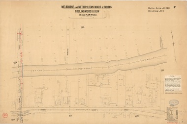
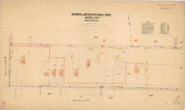
Plan, Melbourne & Metropolitan Board of Works : Borough of Kew : Detail Plan No.1302, 1910
... Original survey plan, issued by the MMBW to a contractor with responsibility for constructing sewers in the area identified on the plan within the Borough of Kew. ...A number of the plans are not held in the collection of the State Library of Victoria so they have the additional attribute of rarity. melbourne and metropolitan board of works, detail plans mmbw 1302 cartography Original survey plan, issued by the MMBW to a contractor with responsibility for constructing sewers in the area identified on the plan within the Borough of Kew. ...The Melbourne and Metropolitan Board of Works (MMBW) plans were produced from the 1890s to the 1950s. They were crucial to the design and development of Melbourne's sewerage and drainage system. The plans, at a scale of 40 feet to 1 inch (1:480), provide a detailed historical record of Melbourne streetscapes and environmental features. Each plan covers one or two street blocks (roughly six streets), showing details of buildings, including garden layouts and ownership boundaries, and features such as laneways, drains, bridges, parks, municipal boundaries and other prominent landmarks as they existed at the time each plan was produced. (Source: State Library of Victoria)This plan forms part of a large group of MMBW plans and maps that was donated to the Society by the Mr Poulter, City Engineer of the City of Kew in 1989. Within this collection, thirty-five hand-coloured plans, backed with linen, are of statewide significance as they include annotations that provide details of construction materials used in buildings in the first decade of the 20th century as well as additional information about land ownership and usage. The copies in the Public Record Office Victoria and the State Library of Victoria are monochrome versions which do not denote building materials so that the maps in this collection are invaluable and unique tools for researchers and heritage consultants. A number of the plans are not held in the collection of the State Library of Victoria so they have the additional attribute of rarity.Original survey plan, issued by the MMBW to a contractor with responsibility for constructing sewers in the area identified on the plan within the Borough of Kew. The plan was at some stage hand-coloured, possibly by the contractor, but more likely by officers working in the Engineering Department of the Borough and later Town, then City of Kew. The hand-coloured sections of buildings on the plan were used to denote masonry or brick constructions (pink), weatherboard constructions (yellow), and public buildings (grey). The absence of buildings and or property in Kew facing the Yarra is the most notable feature of this plan. Walmer Street and its bridge stretched, then and now, from Studley Park Road to Victoria Street, Richmond. On the Richmond side of the Yarra, there was evidence in 1904 of industry (‘Wool shed’; Soap Works’) and entertainment (‘Skittle Alley’). In reality, another Plan (No.1303) shows Chinese Gardens bordering the Yarra on the Kew side and buildings in Young Street.melbourne and metropolitan board of works, detail plans, mmbw 1302, cartography -
 Kew Historical Society Inc
Plan, Melbourne & Metropolitan Board of Works : Borough of Kew : Detail Plan No.1571, 1904
... Original survey plan, issued by the MMBW to a contractor with responsibility for constructing sewers in the area identified on the plan within the Borough of Kew. ...A number of the plans are not held in the collection of the State Library of Victoria so they have the additional attribute of rarity. melbourne and metropolitan board of works, detail plans mmbw 1571 cartography Original survey plan, issued by the MMBW to a contractor with responsibility for constructing sewers in the area identified on the plan within the Borough of Kew. ...The Melbourne and Metropolitan Board of Works (MMBW) plans were produced from the 1890s to the 1950s. They were crucial to the design and development of Melbourne's sewerage and drainage system. The plans, at a scale of 40 feet to 1 inch (1:480), provide a detailed historical record of Melbourne streetscapes and environmental features. Each plan covers one or two street blocks (roughly six streets), showing details of buildings, including garden layouts and ownership boundaries, and features such as laneways, drains, bridges, parks, municipal boundaries and other prominent landmarks as they existed at the time each plan was produced. (Source: State Library of Victoria)This plan forms part of a large group of MMBW plans and maps that was donated to the Society by the Mr Poulter, City Engineer of the City of Kew in 1989. Within this collection, thirty-five hand-coloured plans, backed with linen, are of statewide significance as they include annotations that provide details of construction materials used in buildings in the first decade of the 20th century as well as additional information about land ownership and usage. The copies in the Public Record Office Victoria and the State Library of Victoria are monochrome versions which do not denote building materials so that the maps in this collection are invaluable and unique tools for researchers and heritage consultants. A number of the plans are not held in the collection of the State Library of Victoria so they have the additional attribute of rarity.Original survey plan, issued by the MMBW to a contractor with responsibility for constructing sewers in the area identified on the plan within the Borough of Kew. The plan was at some stage hand-coloured, possibly by the contractor, but more likely by officers working in the Engineering Department of the Borough and later Town, then City of Kew. The hand-coloured sections of buildings on the plan were used to denote masonry or brick constructions (pink), weatherboard constructions (yellow), and public buildings (grey). This plan is the other half of Plan No.1571 representing the constructions to the west of Wellington Street before and in 1903/4. This plan represents the built environment in Edgevale Road, Wellington Street, Atkins Street, Annadale Street, Mortimer Street, and Cotham Road. Whereas there are smaller allotments and more modest housing stock facing Edgevale Road, larger blocks and more substantial houses are represented facing Cotham Road.melbourne and metropolitan board of works, detail plans, mmbw 1571, cartography -
 Kew Historical Society Inc
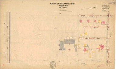
Plan, Melbourne & Metropolitan Board of Works : Borough of Kew : Detail Plan No.1575, 1905
... Original survey plan, issued by the MMBW to a contractor with responsibility for constructing sewers in the area identified on the plan within the Borough of Kew. ...A number of the plans are not held in the collection of the State Library of Victoria so they have the additional attribute of rarity. melbourne and metropolitan board of works, detail plans maps - borough of kew mmbw 1575 cartography Original survey plan, issued by the MMBW to a contractor with responsibility for constructing sewers in the area identified on the plan within the Borough of Kew. ...The Melbourne and Metropolitan Board of Works (MMBW) plans were produced from the 1890s to the 1950s. They were crucial to the design and development of Melbourne's sewerage and drainage system. The plans, at a scale of 40 feet to 1 inch (1:480), provide a detailed historical record of Melbourne streetscapes and environmental features. Each plan covers one or two street blocks (roughly six streets), showing details of buildings, including garden layouts and ownership boundaries, and features such as laneways, drains, bridges, parks, municipal boundaries and other prominent landmarks as they existed at the time each plan was produced. (Source: State Library of Victoria)This plan forms part of a large group of MMBW plans and maps that was donated to the Society by the Mr Poulter, City Engineer of the City of Kew in 1989. Within this collection, thirty-five hand-coloured plans, backed with linen, are of statewide significance as they include annotations that provide details of construction materials used in buildings in the first decade of the 20th century as well as additional information about land ownership and usage. The copies in the Public Record Office Victoria and the State Library of Victoria are monochrome versions which do not denote building materials so that the maps in this collection are invaluable and unique tools for researchers and heritage consultants. A number of the plans are not held in the collection of the State Library of Victoria so they have the additional attribute of rarity.Original survey plan, issued by the MMBW to a contractor with responsibility for constructing sewers in the area identified on the plan within the Borough of Kew. The plan was at some stage hand-coloured, possibly by the contractor, but more likely by officers working in the Engineering Department of the Borough and later Town, then City of Kew. The hand-coloured sections of buildings on the plan were used to denote masonry or brick constructions (pink), weatherboard constructions (yellow), and public buildings (grey). Plan No.1575 shows that in the area bounded by Wellington Street, Edgevale Road, Glenferrie Road, and Cotham Road, there had already been significant subdivision of land and houses constructed. As one of the highest points in Kew, as expected, there were already some significant mansions built on large allotments of land. Many of these mansions are identified by name on the plan such as ‘Kelso’, ‘Abbotsford’, ‘Clarendon’ and ‘Ashlyn’ in Cotham Road. Other houses of equal size are unnamed on the plan.melbourne and metropolitan board of works, detail plans, maps - borough of kew, mmbw 1575, cartography -
 Kew Historical Society Inc
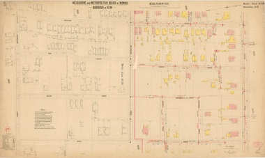
Plan, Melbourne and Metropolitan Board of Works, Borough of Kew : Detail Plan No.1562, 1905
... Original survey plan, issued by the MMBW to a contractor with responsibility for constructing sewers in the area identified on the plan within the Borough of Kew. ...A number of the plans are not held in the collection of the State Library of Victoria so they have the additional attribute of rarity. melbourne and metropolitan board of works, detail plans mmbw 1562 cartography Original survey plan, issued by the MMBW to a contractor with responsibility for constructing sewers in the area identified on the plan within the Borough of Kew. ...The Melbourne and Metropolitan Board of Works (MMBW) plans were produced from the 1890s to the 1950s. They were crucial to the design and development of Melbourne's sewerage and drainage system. The plans, at a scale of 40 feet to 1 inch (1:480), provide a detailed historical record of Melbourne streetscapes and environmental features. Each plan covers one or two street blocks (roughly six streets), showing details of buildings, including garden layouts and ownership boundaries, and features such as laneways, drains, bridges, parks, municipal boundaries and other prominent landmarks as they existed at the time each plan was produced. (Source: State Library of Victoria). This plan forms part of a large group of MMBW plans and maps that was donated to the Society by the Mr Poulter, City Engineer of the City of Kew in 1989. Within this collection, thirty-five hand-coloured plans, backed with linen, are of statewide significance as they include annotations that provide details of construction materials used in buildings in the first decade of the 20th century as well as additional information about land ownership and usage. The copies in the Public Record Office Victoria and the State Library of Victoria are monochrome versions which do not denote building materials so that the maps in this collection are invaluable and unique tools for researchers and heritage consultants. A number of the plans are not held in the collection of the State Library of Victoria so they have the additional attribute of rarity.Original survey plan, issued by the MMBW to a contractor with responsibility for constructing sewers in the area identified on the plan within the Borough of Kew. The plan was at some stage hand-coloured, possibly by the contractor, but more likely by officers working in the Engineering Department of the Borough and later Town, then City of Kew. The hand-coloured sections of buildings on the plan were used to denote masonry or brick constructions (pink), weatherboard constructions (yellow), and public buildings (grey). MMBW detail plan No.1562, in contrast to No.1561 includes the names of a large number of houses: in Barkers Road: ‘Ashwick’, ‘Owasso’, ‘Anadiha’, ‘Eurobin’, ‘Carlsruhe’, ‘Arlington’ and ‘Altyre’. Unnamed but clearly represented on the plan is what was then known as the ‘Auburn Heights Recreation Club’, which at this stage included a Bowling Green, a Croquet Green and two Tennis Courts. On the plan, Brougham Place, as it was then known, is represented. It was later renamed Daniell Place. The aforementioned Arlington is now the junior campus of Preshil. melbourne and metropolitan board of works, detail plans, mmbw 1562, cartography -
 Bendigo Military Museum
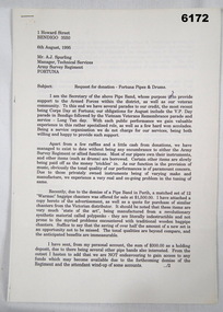
Memorabilia - Fortuna Pipes and Drums Request for Donation, PSJ Barker, Secretary Fortuna pipes and Drums, 06.08.1995
... Using an original Survey Corps Badge c. 1915 provided by former WO1 Keith "Aki" Barber, a number of replica metal Survey Corps theodolite badges were struck and used along with the purple Survey Corps lanyard by the band. ...Using an original Survey Corps Badge c. 1915 provided by former WO1 Keith "Aki" Barber, a number of replica metal Survey Corps theodolite badges were struck and used along with the purple Survey Corps lanyard by the band. ...This is a document requesting a donation for the Fortuna Pipes and Drums for the update of some of their equipment. The members of the band are shown and named in the accompanying photo. Information about the Fortuna Pipes and Drums is also in Valerie Loyejoy's book " Mapmakers of Fortuna, A History of the Army Survey Regiment" ISBN 0-646-42120-4 and included in the Victorian Collection as item 6000. The Band was originally formed in 1993 from members of the local Masonic Lodge and first played for the Survey Corps Day Parade in 1994 after a request from the then RSM WO1 Phil Meagher. The Army was able to provide the original "Black Watch" tartan kilts. Using an original Survey Corps Badge c. 1915 provided by former WO1 Keith "Aki" Barber, a number of replica metal Survey Corps theodolite badges were struck and used along with the purple Survey Corps lanyard by the band. The Fortuna Pipes and Drums continued to actively support the Army Survey Regiment until its disbandment in 1996.A 4 x Page letter, A4 Pages, Typed document, PhotocopyAddressed to Mr Tony Spurling, Manager Technical Services, Army Svy Regt, Fortunaroyal australian survey corps, rasvy, fortuna, army survey regiment, army svy regt, asr -
 Kew Historical Society Inc
Plan, Melbourne & Metropolitan Board of Works : Borough of Kew : Detail Plan No.1578, 1904
... Original survey plan, issued by the MMBW to a contractor with responsibility for constructing sewers in the area identified on the plan within the Borough of Kew. ...A number of the plans are not held in the collection of the State Library of Victoria so they have the additional attribute of rarity. melbourne and metropolitan board of works, detail plans maps - borough of kew mmbw 1578 cartography Original survey plan, issued by the MMBW to a contractor with responsibility for constructing sewers in the area identified on the plan within the Borough of Kew. ...The Melbourne and Metropolitan Board of Works (MMBW) plans were produced from the 1890s to the 1950s. They were crucial to the design and development of Melbourne's sewerage and drainage system. The plans, at a scale of 40 feet to 1 inch (1:480), provide a detailed historical record of Melbourne streetscapes and environmental features. Each plan covers one or two street blocks (roughly six streets), showing details of buildings, including garden layouts and ownership boundaries, and features such as laneways, drains, bridges, parks, municipal boundaries and other prominent landmarks as they existed at the time each plan was produced. (Source: State Library of Victoria). This plan forms part of a large group of MMBW plans and maps that was donated to the Society by the Mr Poulter, City Engineer of the City of Kew in 1989. Within this collection, thirty-five hand-coloured plans, backed with linen, are of statewide significance as they include annotations that provide details of construction materials used in buildings in the first decade of the 20th century as well as additional information about land ownership and usage. The copies in the Public Record Office Victoria and the State Library of Victoria are monochrome versions which do not denote building materials so that the maps in this collection are invaluable and unique tools for researchers and heritage consultants. A number of the plans are not held in the collection of the State Library of Victoria so they have the additional attribute of rarity.Original survey plan, issued by the MMBW to a contractor with responsibility for constructing sewers in the area identified on the plan within the Borough of Kew. The plan was at some stage hand-coloured, possibly by the contractor, but more likely by officers working in the Engineering Department of the Borough and later Town, then City of Kew. The hand-coloured sections of buildings on the plan were used to denote masonry or brick constructions (pink), weatherboard constructions (yellow), and public buildings (grey). MMBW Plan No.1578 is significant in that it defines the extent of two private schools: Xavier College and Kew High School (now part of Trinity Grammar) by 1904. In relation to the latter, the plan clarifies which buildings the High School operated from behind the mansion ‘Molina’. Established in 1902, Trinity Grammar was to later lease and subsequently buy Molina (now ‘Merritt House’) and ‘Elsinore’ (now ‘Roberts House’). Xavier College had been established in 1872. This 1904 plan delineates the West Wing and the Great Hall (built in 1890).melbourne and metropolitan board of works, detail plans, maps - borough of kew, mmbw 1578, cartography -
 Kew Historical Society Inc
Plan, Melbourne & Metropolitan Board of Works : Borough of Kew : Detail Plan No.1590, 1905
... Original survey plan, issued by the MMBW to a contractor with responsibility for constructing sewers in the area identified on the plan within the Borough of Kew. ...A number of the plans are not held in the collection of the State Library of Victoria so they have the additional attribute of rarity. melbourne and metropolitan board of works, detail plans mmbw 1590 survey plans - borough of kew cartography Original survey plan, issued by the MMBW to a contractor with responsibility for constructing sewers in the area identified on the plan within the Borough of Kew. ...The Melbourne and Metropolitan Board of Works (MMBW) plans were produced from the 1890s to the 1950s. They were crucial to the design and development of Melbourne's sewerage and drainage system. The plans, at a scale of 40 feet to 1 inch (1:480), provide a detailed historical record of Melbourne streetscapes and environmental features. Each plan covers one or two street blocks (roughly six streets), showing details of buildings, including garden layouts and ownership boundaries, and features such as laneways, drains, bridges, parks, municipal boundaries and other prominent landmarks as they existed at the time each plan was produced. (Source: State Library of Victoria)This plan forms part of a large group of MMBW plans and maps that was donated to the Society by the Mr Poulter, City Engineer of the City of Kew in 1989. Within this collection, thirty-five hand-coloured plans, backed with linen, are of statewide significance as they include annotations that provide details of construction materials used in buildings in the first decade of the 20th century as well as additional information about land ownership and usage. The copies in the Public Record Office Victoria and the State Library of Victoria are monochrome versions which do not denote building materials so that the maps in this collection are invaluable and unique tools for researchers and heritage consultants. A number of the plans are not held in the collection of the State Library of Victoria so they have the additional attribute of rarity.Original survey plan, issued by the MMBW to a contractor with responsibility for constructing sewers in the area identified on the plan within the Borough of Kew. The plan was at some stage hand-coloured, possibly by the contractor, but more likely by officers working in the Engineering Department of the Borough and later Town, then City of Kew. The hand-coloured sections of buildings on the plan were used to denote masonry or brick constructions (pink), weatherboard constructions (yellow), and public buildings (grey). Surveyed by the Board of Works in 1903 and published in 1904, Plan No.1590 shows development north of Cotham Road. While this plan includes built structures in Mary Street, Cotham Road, High Street, Park Hill Road, Kent Street, Ridgeway Avenue, and Ermington Lane (now Ermington Place), only part of this section was notated and coloured in this contractor’s copy. Numerous houses, large and small are named on the plan: ‘Cholula’, ‘Belper’, ‘The Uplands’, ‘Spring Grove’ facing Cotham Road; ‘Marion’ facing Kent Street; and ‘Kia Ora’ facing Ridgeway Avenue.melbourne and metropolitan board of works, detail plans, mmbw 1590, survey plans - borough of kew, cartography