Showing 110 items matching "overflow"
-
 Tarnagulla History Archive
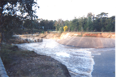
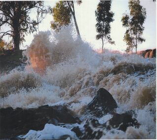
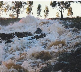
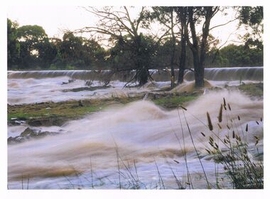
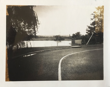
Photograph, Overflow at Laanecoorie Reservoir, August 1993
... Overflow at Laanecoorie Reservoir...A photograph depicting overflow at Laanecoorie Reservoir in August 1993. ...Original photograph. Overflow at Laanecoorie Reservoir Photograph Photograph ...Donald Clark Collection. A photograph depicting overflow at Laanecoorie Reservoir in August 1993. Original photograph. water -
 Ringwood and District Historical Society
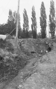
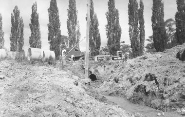
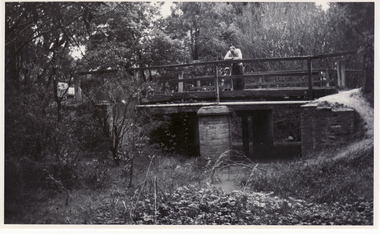
Photograph, Maroondah Highway East, Ringwood. Excavations for Ringwood Lake overflow, 1963
... Excavations for Ringwood Lake overflow, 1963....Written below one photograph: "Ringwood Lake overflow pipe (under Maroondah Highway) - 1963". ...Excavations for Ringwood Lake overflow, 1963. Photograph ...Black and white photograph (3 copies- 2 large, 1 small)Written below one photograph: "Ringwood Lake overflow pipe (under Maroondah Highway) - 1963". Typed below a similar image: "Overflow from Ringwood Lake- 1963." -
 Kew Historical Society Inc
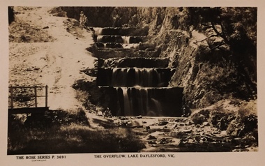
Postcard, The Overflow, Lake Daylesford, Vic
... The Overflow, Lake Daylesford, Vic...Sepia postcard of the artificially-created, stone-stepped overflow from Lake Daylesford ...The postcards are part of a larger collection of photographs, postcards and publications donated to the collection in May 2021. postcards -- daylesford christian-washfold collection The Rose Series P. 3691 Sepia postcard of the artificially-created, stone-stepped overflow from Lake Daylesford The Overflow, Lake Daylesford, Vic Postcard ...One of a number of 'real photo' and commercial postcards created by or owned by members of the Christian and Washfold families of Kew. The postcards are part of a larger collection of photographs, postcards and publications donated to the collection in May 2021.Sepia postcard of the artificially-created, stone-stepped overflow from Lake Daylesford The Rose Series P. 3691postcards -- daylesford, christian-washfold collection -
 Ringwood and District Historical Society
Photograph, Maroondah Highway East, Ringwood- 963. Excavations for Ringwood Lake overflow
... Excavations for Ringwood Lake overflow....Written on rear of backing sheet, "Excavations for Ringwood Lake overflow- 1963."...Excavations for Ringwood Lake overflow. Photograph ...Black and white photograph (2 copies- 1 large, 1 smaller)Written on rear of backing sheet, "Excavations for Ringwood Lake overflow- 1963." -
 Ringwood and District Historical Society
Photograph, Ringwood Lake Overflow Pipe
... Ringwood Lake Overflow Pipe...Typed below photograph, "Ringwood Lake overflow pipe (Passing under Maroondah Highway) 1963"....Equipment and men on roadway above open pipe. Ringwood Lake Overflow Pipe Photograph ...Black and white photograph of drainage works. Poplars in the background. Equipment and men on roadway above open pipe.Typed below photograph, "Ringwood Lake overflow pipe (Passing under Maroondah Highway) 1963". -
 Ringwood and District Historical Society
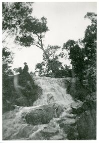
Photograph, Loughnan Lake overflow c.1930, c.1930
... Loughnan Lake overflow c.1930....Loughnan Lake overflow c.1930. Strong flow of water over waterfall. ...Man & dog sitting at top of the waterfall. Loughnan Lake overflow c.1930. Photograph Photograph ...Loughnan Lake overflow c.1930. Strong flow of water over waterfall. Man & dog sitting at top of the waterfall. -
 Ringwood and District Historical Society
Photograph, Maroondah Highway East, Ringwood- 1963. Excavations for Ringwood Lake overflow
... Excavations for Ringwood Lake overflow. ...Typed on rear of backing sheet of large photograph: "Ringwood lake overflow pipe. (Passing under Maroondah Highway). 1963....Excavations for Ringwood Lake overflow. Photograph ...Black and white photograph (2 copies- 1 large, 1 smaller)Typed on rear of backing sheet of large photograph: "Ringwood lake overflow pipe. (Passing under Maroondah Highway). 1963. -
 Lake Bolac & District Historical Society
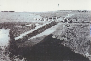
Black and white photograph, Lake Bolac Overflow and Weir, circa 1949
... Lake Bolac Overflow and Weir, circa 1949....The concrete weir and water-level adjusted overflow into the man-made channel into Salt Creek on the south side of the lake, circa 1949. ...Malin's windmill and pump can be seen on the bank in the background. lake bolac, salt creek, overflow, moreton, malin, windmill Lake Bolac Overflow and Weir, circa 1949. ...Lake Bolac. The concrete weir and water-level adjusted overflow into the man-made channel into Salt Creek on the south side of the lake, circa 1949. The Moreton family is playing in the shallow trickle of water. Malin's windmill and pump can be seen on the bank in the background.lake bolac, salt creek, overflow, moreton, malin, windmill -
 Lake Bolac & District Historical Society
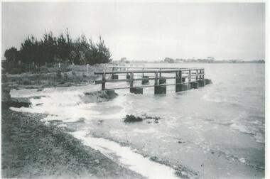
Black and white photograph, Lake Bolac Overflow, 1956
... Lake Bolac Overflow, 1956...The outlet for the overflow was originally cut in 1926 and concreted over in 1928. ...Lake Bolac & District Historical Society 2110 Glenelg Highway Lake Bolac grampians The outlet for the overflow was originally cut in 1926 and concreted over in 1928. ...The outlet for the overflow was originally cut in 1926 and concreted over in 1928. This photo shows flooding into Salt Creek in 1956 and looks towards the west and Rockbank. Boards were added to raise the water level of the lake. These were put in annually, below the walkway depicted, until in 1966 the level of the concrete weir was raised. Consequently the lake did not flush through as readily and it gradually silted up and the lake became shallower.lake bolac, overflow, 1926, 1928, flood, 1966, salt creek, rockbank -
 Inverloch Historical Society
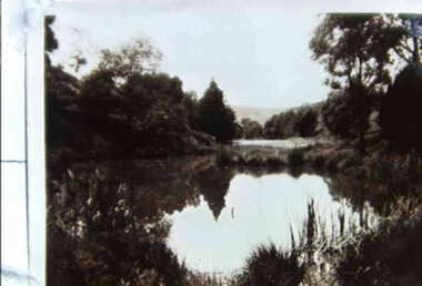
000677 - Photograph - 1929 - Leongatha - Reflections in Overflow of old Reservoir - from J Fincher
... 000677 - Photograph - 1929 - Leongatha - Reflections in Overflow of old Reservoir - from J Fincher...Inverloch gippsland 000677 - Photograph - 1929 - Leongatha - Reflections in Overflow of old Reservoir - from J Fincher ... -
 Inverloch Historical Society
000678 - Photograph - 1929 - Leongatha - Reflections in Overflow of old Reservoir - from J Fincher
... 000678 - Photograph - 1929 - Leongatha - Reflections in Overflow of old Reservoir - from J Fincher...Inverloch gippsland 000678 - Photograph - 1929 - Leongatha - Reflections in Overflow of old Reservoir - from J Fincher ... -
 Malmsbury Historical Society
Photograph (Item), Western Spillway concrete Overflow, Malmsbury ca1990
... Western Spillway concrete Overflow, Malmsbury ca1990...Malmsbury Historical Society Malmsbury Mechanics Institute 71 Mollison Street Malmsbury daylesford-and-the-macedon-ranges Buildings - Concrete Spillway Western Spillway concrete Overflow, Malmsbury ca1990 Photograph Photograph ...Buildings - Concrete Spillway -
 Stawell Historical Society Inc
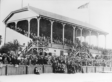
Photograph, Grandstand No1 in Central Park c 1929 with a large crowd
... Grandstand No1 Central Park c 1929 with very large crowd of people overflowing from the grandstand. Picket fence in foreground with rows of people behind and overflowing onto the oval....Grand Stand full of people and overflowing down the stairs with many rows of people standing between the stand and picket fence of oval....Stawell Historical Society Inc 46 Longfield St Stawell grampians Grandstand No1 Central Park c 1929 with very large crowd of people overflowing from the grandstand. Picket fence in foreground with rows of people behind and overflowing onto the oval. stawell Grand Stand full of people and overflowing down the stairs with many rows of people standing between the stand and picket fence of oval. ...Grandstand No1 Central Park c 1929 with very large crowd of people overflowing from the grandstand. Picket fence in foreground with rows of people behind and overflowing onto the oval.Grand Stand full of people and overflowing down the stairs with many rows of people standing between the stand and picket fence of oval.stawell -
 Federation University Art Collection
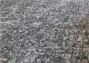
Drawing, Scott Pearce, 'Christmas Eve' by Scott Pearce, 2008
... Framed drawing of an overflowing carpark on Christmas Eve, ...The Art Collection features over 2000 works and was listed as a 'Ballarat Treasure' in 2007. art artwork scott pearce pearce carpark drawing alumni Christmas Framed drawing of an overflowing carpark on Christmas Eve, 'Christmas Eve' by Scott Pearce Drawing Scott Pearce ...Scott PEARCE (1972 - ) Scott Pearce was awarded at Ballarat Arts Foundation Award in 2005. He completed at Bachelor of Visual Art: Painting (Honours) at the University of Ballarat (now Federation University) in 2007. This item is part of the Federation University Art Collection. The Art Collection features over 2000 works and was listed as a 'Ballarat Treasure' in 2007.Framed drawing of an overflowing carpark on Christmas Eve, art, artwork, scott pearce, pearce, carpark, drawing, alumni, christmas -
 Bendigo Historical Society Inc.
Photograph - HUGH ENNES COLLECTION: EPPALOCK WEIR WATER OVERFLOW - JAN 2011
... Colour photograph. Water overflows from Eppalock Weir, January 2011....Colour photograph. Water overflows from Eppalock Weir, January 2011. Photograph HUGH ENNES COLLECTION: EPPALOCK WEIR WATER OVERFLOW - JAN 2011 ...The Hugh Ennes collection. Colour photograph. Water overflows from Eppalock Weir, January 2011.state infrastructure, water supply, coliban system -
 Bendigo Historical Society Inc.
Photograph - HUGH ENNES COLLECTION: EPPALOCK WEIR WATER OVERFLOW - JAN 2011
... Colour photograph. Water overflows from Eppalock Weir, January 2011....Colour photograph. Water overflows from Eppalock Weir, January 2011. Photograph HUGH ENNES COLLECTION: EPPALOCK WEIR WATER OVERFLOW - JAN 2011 ...The Hugh Ennes collection. Colour photograph. Water overflows from Eppalock Weir, January 2011.railways, bendigo to melbourne, trains. railways. puffing billy. wirths circus. -
 Bendigo Historical Society Inc.
Photograph - HUGH ENNES COLLECTION: EPPALOCK WEIR WATER OVERFLOW - JAN 2011
... Colour photograph. Water overflows from Eppalock Weir, January 2011....Colour photograph. Water overflows from Eppalock Weir, January 2011. Photograph HUGH ENNES COLLECTION: EPPALOCK WEIR WATER OVERFLOW - JAN 2011 ...The Hugh Ennes collection. Colour photograph. Water overflows from Eppalock Weir, January 2011.state infrastructure, water supply, coliban system, eppalock weir. coliban system. -
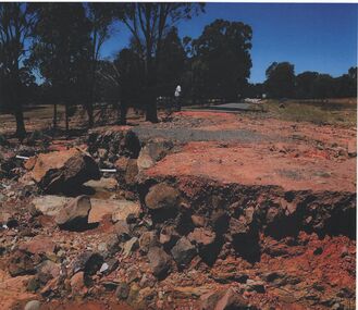 Bendigo Historical Society Inc.
Photograph - HUGH ENNES COLLECTION: EPPALOCK WEIR WATER OVERFLOW - JAN 2011
... Erosion after water overflows from Eppalock Weir, January 2011....Erosion after water overflows from Eppalock Weir, January 2011. Photograph HUGH ENNES COLLECTION: EPPALOCK WEIR WATER OVERFLOW - JAN 2011 ...The Hugh Ennes collection. Colour photograph. Erosion after water overflows from Eppalock Weir, January 2011.state infrastructure, water supply, coliban system -
 Federation University Historical Collection
Photograph - Colour, Dam on Mt Helen Campus, 2019, 11/05/2019
... ...overflow...Barker Library (top floor) Mount Helen goldfields mt helen campus dam overflow Colour photograph of the Mt Helen Campus Swimming Pool. ...Colour photograph of the Mt Helen Campus Swimming Pool.mt helen campus, dam, overflow -
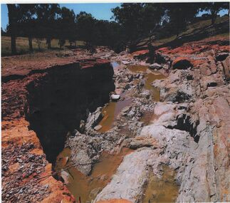 Bendigo Historical Society Inc.
Photograph - HUGH ENNES COLLECTION: EPPALOCK WEIR WATER OVERFLOW - JAN 2011
... Erosion after water overflows from Eppalock Weir, January 2011. ...Photograph HUGH ENNES COLLECTION: EPPALOCK WEIR WATER OVERFLOW - JAN 2011 ...The Hugh Ennes collection. Colour photograph. Erosion after water overflows from Eppalock Weir, January 2011. There are two copies of thios photo.state infrastructure, water supply, coliban system -
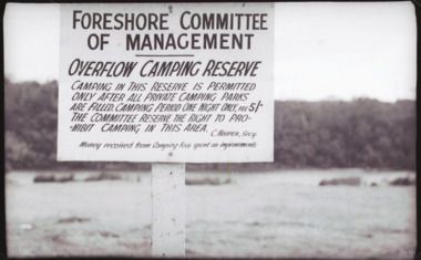 Lakes Entrance Historical Society
Photograph - Camping Lakes Entrance, Bulmer, 1950 c
... Black and white photograph of sign erected by the Foreshore Committee of Manaagement on the overflow camping reserve adjacent to the North Arm Marine Parade Lakes Entrance Victoria...Lakes Entrance Historical Society 4 Marine Parade Lakes Entrance gippsland Camping Regulations Tourism Black and white photograph of sign erected by the Foreshore Committee of Manaagement on the overflow camping reserve adjacent to the North Arm Marine Parade Lakes Entrance Victoria Photograph Camping Lakes Entrance Bulmer ...Black and white photograph of sign erected by the Foreshore Committee of Manaagement on the overflow camping reserve adjacent to the North Arm Marine Parade Lakes Entrance Victoriacamping, regulations, tourism -
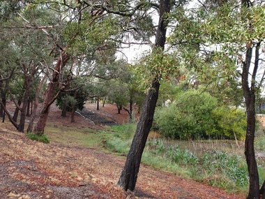
 Whitehorse Historical Society Inc.
Photograph, Lake Road Bridge Blackburn, 1962
... Demolished in 1965 Photo shows the lake overflow area....Demolished in 1965 Photo shows the lake overflow area. Lake Road Bridge Blackburn Photograph Photograph ...Black and white photo of bridge over Lake Road, Blackburn. c1888. Made of Blackburn Bricks. Demolished in 1965 Photo shows the lake overflow area.lake road blackburn, lake road bridge blackburn -
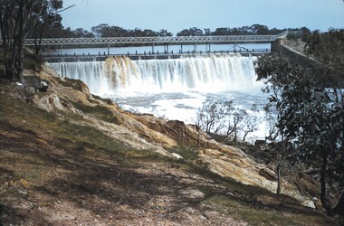 Bendigo Historical Society Inc.
Slide - BENDIGO VIEWS, Sep 1960
... There is a stel structure above the overflow. There is a man to the left of the picture. ...There is a stel structure above the overflow. There is a man to the left of the picture. ...Slide. Bendigo Views. View of the water flowing over the Laanacoorie Weir. There is a stel structure above the overflow. There is a man to the left of the picture. In the foreground is rocky ground and some trees.slide, bendigo, bendigo views, bendigo views -
Bendigo Historical Society Inc.
Map - PLAN OF THE BENDIGO RAILWAY YARD, Circa 1960
... Image in Mosaic images overflow....Image in Mosaic images overflow. Map PLAN OF THE BENDIGO RAILWAY YARD ...Map: Plan of the Bendigo Railway Yards, Scale: 80 feet to 1 inch. 1960's. (number 319 in map cupboard 1) Location unknown. Image in Mosaic images overflow.map, bendigo, railway yard, railways, rail yards, station layout -
Tatura Irrigation & Wartime Camps Museum
Photograph, Goulburn Weir, 1890
... Earth and rubble bank bottom right corner - Concrete spillway and platform - overflow water in foreground - Trees on horizon - Dwelling left middle distance...Earth and rubble bank bottom right corner - Concrete spillway and platform - overflow water in foreground - Trees on horizon - Dwelling left middle distance Goulburn Weir Photograph ...Taken by photographer for State Rivers and Water Supply Commission.Medium sized black and white photograph. Earth and rubble bank bottom right corner - Concrete spillway and platform - overflow water in foreground - Trees on horizon - Dwelling left middle distancevictoria state rivers and water supply commission, goulburn weir -
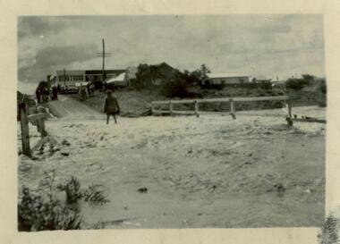 Sunshine and District Historical Society Incorporated
Photograph - Flood of Kororoit Creek Derby Bridge 1954, 1954
... 1954 Photograph of KOROROIT CREEK in flood and overflowing the DERBY RD BRIDGE in Sunshine. Short time later this bridge was declared unsafe and closed to vehicle traffic. ...Brimbank Library, 301 Hampshire Road, Sunshine 3020. melbourne Derby Rd Bridge Flood Kororoit Creek Sunshine Technical School 1954 1954 Photograph of KOROROIT CREEK in flood and overflowing the DERBY RD BRIDGE in Sunshine. Short time later this bridge was declared unsafe and closed to vehicle traffic. ...derby rd bridge, flood, kororoit creek, sunshine technical school, 1954 -
Tatura Irrigation & Wartime Camps Museum
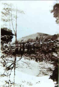
Photograph, Eildon Township, 1957
... Aerial photograph - looking down on township in middle foreground - overflow dam to the right, middle distance - dam wall with reservoir beyond - mountain tops forming horizon...Aerial photograph - looking down on township in middle foreground - overflow dam to the right, middle distance - dam wall with reservoir beyond - mountain tops forming horizon Eildon Township Photograph ...Taken by photographer for State Rivers and Water Supply Commission.Medium sized black and white photo. Aerial photograph - looking down on township in middle foreground - overflow dam to the right, middle distance - dam wall with reservoir beyond - mountain tops forming horizonOn frame below photo: "Eildon Township."victoria state rivers and water supply commission, eildon -
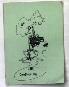 Orbost & District Historical Society
magazine, Croajingalong 1985, 1985
... It is titled "Croajingalong 1985" The cartoon represents the passing on of knowledge into an overflowing cup. On the back cover is a section for autographs....It is titled "Croajingalong 1985" The cartoon represents the passing on of knowledge into an overflowing cup. On the back cover is a section for autographs. ...The name Croajingolong derives from the Australian Aboriginal Krauatungalung words galung, meaning "belonging to" and kraua, meaning "east". This is the thirty-eighth edition of the annual magazine of Orbost High School. The magazine belonged to Mary Gilbert, a former teacher at the school. Orbost High School / Orbost Secondary College has played a significant part in the education of senior students in the Orbost district . It is the sole senior educational institution. This magazine is representative of its history and is a useful reference tool.A rectangular 48 pp magazine with a pale green cover which has a black print stylised cartoon in the centre. It is titled "Croajingalong 1985" The cartoon represents the passing on of knowledge into an overflowing cup. On the back cover is a section for autographs. -
 Kew Historical Society Inc
Photograph - Flooding of the Yarra Valley at Kew East, 1974
... Flooding was caused by overflowing water in Glass' Creek and the River Yarra. ...Flooding was caused by overflowing water in Glass' Creek and the River Yarra. ...Flooding of the Yarra Valley, including that section of the Yarra bordering Kew and Kew East in the north and west of the municipality, was a regular occurrence. Extreme flood events of the Yarra River are recorded to have occurred in 1891, 1901, 1916, 1923 and 1934. The Municipality of Kew's response to these floods was to enact planning decisions restricting residential development in flood prone areas following the floods of 1916, 1921 and 1934. While floods continued after the development of the Upper Yarra Reservoir (construction 1948-57), the regularity and extent of these inundations diminished. During the nineteenth century, the land abutting the south side of the Yarra in Kew was devoted to dairy farming. In the twentieth century, before and after the construction of the Eastern Freeway, much of this low-lying area was used as golf courses and public parks.Late example of the capacity of the Yarra Valley at Kew to flood, even though drainage works and the Upper Yarra Reservoir had reduced their regularity.Original black and white print photograph of Hay's Paddock under floodwater on 16 May 1974. The vantage point of the photographer is Keystone Crescent looking east. Flooding was caused by overflowing water in Glass' Creek and the River Yarra. Annotation verso: "Keystone Cr looking east / 16 May 1974 11.50am"hays paddock, floods, yarra river, glass' creek -
 Kew Historical Society Inc
Photograph - Flooding of the Yarra Valley at Kew East, 1974
... Flooding was caused by overflowing water in Glass' Creek and the River Yarra. ...Flooding was caused by overflowing water in Glass' Creek and the River Yarra. ...Flooding of the Yarra Valley, including that section of the Yarra bordering Kew and Kew East in the north and west of the municipality, was a regular occurrence. Extreme flood events of the Yarra River are recorded to have occurred in 1891, 1901, 1916, 1923 and 1934. The Municipality of Kew's response to these floods was to enact planning decisions restricting residential development in flood prone areas following the floods of 1916, 1921 and 1934. While floods continued after the development of the Upper Yarra Reservoir (construction 1948-57), the regularity and extent of these inundations diminished. During the nineteenth century, the land abutting the south side of the Yarra in Kew was devoted to dairy farming. In the twentieth century, before and after the construction of the Eastern Freeway, much of this low-lying area was used as golf courses and public parks.Late example of the capacity of the Yarra Valley at Kew to flood, even though drainage works and the Upper Yarra Reservoir had reduced their regularity.Original black and white print photograph of the low-lying land at East Kew under floodwater on 16 May 1974. The vantage point of the photographer is Lister Street. Flooding was caused by overflowing water in Glass' Creek and the River Yarra. Annotation verso: "Lister Street looking north / Flood level / 16 May 1974 11.30am / R.L. 46.04"hays paddock, floods, yarra river, glass' creek, lister street