Showing 2546 items matching "parish"
-
 Ringwood and District Historical Society
Newspaper - Newsletters, Djerrnong Anglican Parish of Heathmont and Ringwood East: "Pews News" 2008, January 2008
... Djerrnong Anglican Parish of Heathmont and Ringwood East: "Pews News" 2008....; Djerriong - Anglican Parish of Heathmont and Ringwood East....Djerriong - Anglican Parish of Heathmont and Ringwood East....Djerriong - Anglican Parish of Heathmont and Ringwood East.....; Djerriong - Anglican Parish of Heathmont and Ringwood East. Djerrnong Anglican Parish of Heathmont and Ringwood East: "Pews News" 2008 Newspaper Newsletters Djerriong - Anglican Parish of Heathmont and Ringwood East. ...Pews News created by the church to disseminate current news and information. This was the time that the final service at Ringwood East took place on 27-Jan-2008.Two issues of Pews News - 13 January 2008 and 20 January 2008, created by the church to disseminate current news and information. Pamphlets white bifold with black printing. Qty 2.; Djerriong - Anglican Parish of Heathmont and Ringwood East. -
Ringwood and District Historical Society
Newsletters, Newton Press, 'The Spirit' Quarterly newsletters: Mar-1985 and Jun-1985. Published by the people of the Holy Spirit Parish, North Ringwood, 1985
... Published by the people of the Holy Spirit Parish, North Ringwood....Published by the people of the Holy Spirit Parish....The people of the Holy Spirit Parish...Published by the people of the Holy Spirit Parish, North Ringwood. Newsletters Newton Press The people of the Holy Spirit Parish ...'The Spirit' Quarterly newsletters: Mar-1985 and Jun-1985. Published by the people of the Holy Spirit Parish. -
 Greensborough Historical Society
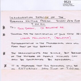
Memorabilia - Document, Rosanna Uniting Parish, Rosanna Uniting Parish The Inauguration Service - Information Sheet, 26/06/1977
... Rosanna Uniting Parish The Inauguration Service - Information Sheet...Information Sheet for the Inauguration Service at The Rosanna Uniting Parish on 26th June 1977. Mrs Morgan participated in this service....Rosanna Uniting Parish...Rosanna Uniting Parish The Inauguration Service - Information Sheet Memorabilia Document Rosanna Uniting Parish ...Information Sheet for the Inauguration Service at The Rosanna Uniting Parish on 26th June 1977. Mrs Morgan participated in this service.Bruce Morgan was the first Shire Secretary (1964-1983) of the Shire of Diamond Valley. This collection was compiled by his wife, Mavis Morgan, detailing the events they attended in their official capacity1 page sheet handwritten in black and red ink.bruce morgan, mavis morgan, rosanna uniting parish, rosanna uniting church -
 Ringwood and District Historical Society
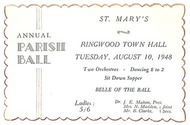
Memorabilia, Ticket for St Mary's Annual Parish Ball, Ringwood, Victoria - 1948, 10-Aug-48
... Ticket for St Mary's Annual Parish Ball, Ringwood, Victoria - 1948...Ticket for St Mary's Annual Parish Ball - Two orchestras, dancing 8-2, sit down supper and Belle of the Ball....St. Mary's Parish...Mary's Parish ...Ticket for St Mary's Annual Parish Ball - Two orchestras, dancing 8-2, sit down supper and Belle of the Ball.Buff coloured card with green printing and deckled edge. Ringwood Town Hall. Tuesday, August 10, 1948. Two orhestras - Dancing 8 to 2. Sit Down Supper. Belle of the Ball. Ladies: 5/6 Dr. J.E. Mahon, Pres. Mrs. N. Madden, Mr. B. Clarke, Joint Secs. -
 Ringwood and District Historical Society
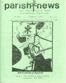
Newsletter, St Paul's Anglican Church Ringwood Victoria - Parish Newsletter Collection 1980s & 1990s (incomplete), 1983-1996
... St Paul's Anglican Church Ringwood Victoria - Parish Newsletter Collection 1980s & 1990s (incomplete)....Collection of Parish News monthly newsletter of St. Pail's Anglican Church, Ringwood...Approximately 100 Monthly Parish newsletters from St. Paul's Anglican Church, April 1983 then October 1986 to September 1996...Parish news...Ringwood and District Historical Society 125A Warrandyte Road Ringwood North melbourne Collection of Parish News monthly newsletter of St. Pail's Anglican Church, Ringwood Parish news Approximately 100 Monthly Parish newsletters from St. ...Collection of Parish News monthly newsletter of St. Pail's Anglican Church, RingwoodApproximately 100 Monthly Parish newsletters from St. Paul's Anglican Church, April 1983 then October 1986 to September 1996. (1986 - October & November only; 1987 - August only. Missing - July 1988, September 1992.) A4 bifold various coloured covers. Stapled.Parish news -
Whitehorse Historical Society Inc.
Map, Parish of Boroondara and Parish of Nunawading, 1850
... Parish of Boroondara and Parish of Nunawading... Note on verso: Plan of 22 portions marked in the Parish of Boroondara and 6 portions in the Parish of Nunawading c1850...Note on verso: Plan of 22 portions marked in the Parish of Boroondara and 6 portions in the Parish of Nunawading c1850...Whitehorse Historical Society Inc. 2-10 Deep Creek Road Mitcham melbourne Note on verso: Plan of 22 portions marked in the Parish of Boroondara and 6 portions in the Parish of Nunawading c1850 Maps Parish of Boroondara Parish of Nunawading Photocopy of manuscript map. ...Photocopy of manuscript map.Photocopy of manuscript map. Note on verso: Plan of 22 portions marked in the Parish of Boroondara and 6 portions in the Parish of Nunawading c1850Photocopy of manuscript map. maps, parish of boroondara, parish of nunawading -
 Narre Warren and District Family History Group
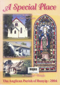
Book, Bunyip Parish Council, A special place - The Anglican Parish of Bunyip - 2004, 2004
... A special place - The Anglican Parish of Bunyip - 2004...Bunyip Parish Council...(RHSV) A special place - The Anglican Parish of Bunyip - 2004 Book Bunyip Parish Council ...This history of the Parish of Bunyip, in West Gippsland, Victoria, was produced to mark the 110th Anniversary of the opening of the parishes oldest place of worship - St John's Anglican Church Nar Nar Goon. It includes chronological events and activities in the three churches of the parish, a list of ministers of the Parish.,and section of recipes contributed by parishioners. (RHSV)non-fictionThis history of the Parish of Bunyip, in West Gippsland, Victoria, was produced to mark the 110th Anniversary of the opening of the parishes oldest place of worship - St John's Anglican Church Nar Nar Goon. It includes chronological events and activities in the three churches of the parish, a list of ministers of the Parish.,and section of recipes contributed by parishioners. (RHSV)st john's church bunyip, st mary's church garfield, st john's church, nar nar goon -
 Melbourne Tram Museum
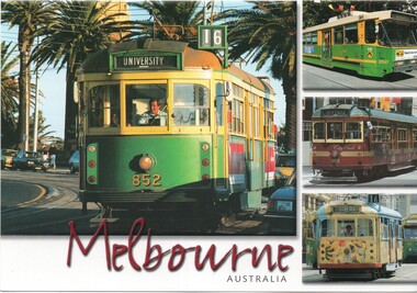
Postcard - Steve Parish, four panel Melbourne trams, Steve Parish Publishing Pty Ltd
... Produced by Steve Parish Publishing of Archerfield Qld. Has space for stamp, address and message on rear. ...Postcard - Steve Parish, four panel Melbourne trams...Steve Parish Publishing Pty Ltd...Yields information about various Melbourne trams during the 1990's and 2000's trams tramcars tramways tram 852 tram 2047 tram 909 tram 729 route 16 City Circle SW5 class tram B2 class trams SW6 class tram Postcard - Steve Parish, four panel Melbourne trams Postcard Steve Parish, four panel Melbourne trams Steve Parish Publishing Pty Ltd ...Postcard featuring trams SW5 852 (University route 16), B2 2047, SW6 909 (City Circle), and SW5 729 (St Kilda Beach, route 16) with the title Melbourne Australia. Produced by Steve Parish Publishing of Archerfield Qld. Has space for stamp, address and message on rear. Yields information about various Melbourne trams during the 1990's and 2000'sPostcard - Steve Parish, four panel Melbourne tramstrams, tramcars, tramways, tram 852, tram 2047, tram 909, tram 729, route 16, city circle, sw5 class tram, b2 class trams, sw6 class tram -
 Ringwood and District Historical Society
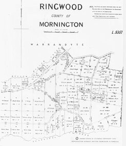
Map, Parish map of Ringwood, County of Mornington - 1878
... Parish map of Ringwood, County of Mornington - 1878....Black and white copy of part of Parish Map Collection...Written on rear of backing sheet: "SLV Parish Map Collection Vol.23, Fol.64."...Written on rear of backing sheet: "SLV Parish Map Collection Vol.23, Fol.64." Black and white copy of part of Parish Map Collection Parish map of Ringwood, County of Mornington - 1878. ...Black and white copy of part of Parish Map CollectionWritten on rear of backing sheet: "SLV Parish Map Collection Vol.23, Fol.64." -
Whitehorse Historical Society Inc.
Map, Parish of Bulleen, 1892
... Parish of Bulleen... together with North-East portion of the Parish of Nunawading....Copy of map of the Parish of Bulleen together with North-East portion of the Parish of Nunawading....Whitehorse Historical Society Inc. 2-10 Deep Creek Road Mitcham melbourne together with North-East portion of the Parish of Nunawading. Maps Parish of Bulleen Parish of Nunawading Copy of map of the Parish of Bulleen Copy of map of the Parish of Bulleen together with North-East portion of the Parish of Nunawading. ...Copy of map of the Parish of BulleenCopy of map of the Parish of Bulleen together with North-East portion of the Parish of Nunawading.Copy of map of the Parish of Bulleenmaps, parish of bulleen, parish of nunawading -
 Ringwood and District Historical Society
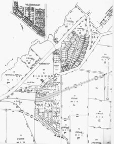
Map, Parish Map - Township of Ringwood - 1890
... Parish Map - Township of Ringwood - 1890....Black and white copy of part of Parish Map Collection...Written on rear of backing sheet: "SLV Parish Map Collection. Vol.67, Fol. 43, 1890." ...Black and white copy of part of Parish Map Collection Parish Map - Township of Ringwood - 1890. ...Black and white copy of part of Parish Map CollectionWritten on rear of backing sheet: "SLV Parish Map Collection. Vol.67, Fol. 43, 1890." -
Clunes Museum
Plan - TITLE PLAN, DEPARTMENT OF LANDS AND SURVEY, PARISH OF CLUNES - COUNTY OF TALBOT, 1959
... PARISH OF CLUNES - COUNTY OF TALBOT....1 1 PAGE PLAN LISTING TITLES FOR THE PARISH OF CLUNES 1959 (3 COPIES) SHEET 1 SCALE: 1 INCH TO 40 CHAINS .2 1 PAGE PLAN LISTING TITLES FOR THE PARISH OF CLUNES 1959 SHEET 2 SCALE: 1 INCH TO 2 CHAINS...PRINTER, MELBOURNE PARISH OF CLUNES...PRINTER, MELBOURNE PARISH OF CLUNES .1 1 PAGE PLAN LISTING TITLES FOR THE PARISH OF CLUNES 1959 (3 COPIES) SHEET 1 SCALE: 1 INCH TO 40 CHAINS .2 1 PAGE PLAN LISTING TITLES FOR THE PARISH OF CLUNES 1959 SHEET 2 SCALE: 1 INCH TO 2 CHAINS PARISH OF CLUNES - COUNTY OF TALBOT Plan TITLE PLAN DEPARTMENT OF LANDS AND SURVEY A.C. ....1 1 PAGE PLAN LISTING TITLES FOR THE PARISH OF CLUNES 1959 (3 COPIES) SHEET 1 SCALE: 1 INCH TO 40 CHAINS .2 1 PAGE PLAN LISTING TITLES FOR THE PARISH OF CLUNES 1959 SHEET 2 SCALE: 1 INCH TO 2 CHAINSBY AUTHORITY A C BROOKS GOVT. PRINTER, MELBOURNE PARISH OF CLUNESparish of clunes, title plans clunes -
Emerald Museum & Nobelius Heritage Park
Map - Land Capability Study of the Shire of Cardinia, parish of Emerald, c1996
... Land Capability Study of the Shire of Cardinia, parish of Emerald...Image of a land capability study map in the Shire of Cardinia, parish Parcels of Emerald...A land Capability Study of the Shire of Cardinia/Map Units and Parish parcels of Emerald/C1996...Emerald Museum & Nobelius Heritage Park 5 Crichton Rd Emerald yarra-valley-and-the-dandenong-ranges A land Capability Study of the Shire of Cardinia/Map Units and Parish parcels of Emerald/C1996 Image of a land capability study map in the Shire of Cardinia, parish Parcels of Emerald Land Capability Study of the Shire of Cardinia, parish of Emerald Map Land Capability Study of the Shire of Cardinia, parish of Emerald ...Image of a land capability study map in the Shire of Cardinia, parish Parcels of EmeraldA land Capability Study of the Shire of Cardinia/Map Units and Parish parcels of Emerald/C1996 -
Whitehorse Historical Society Inc.
Pamphlet, The Parish of St John The Evangelist, Mitcham, 24/06/2000 12:00:00 AM
... The Parish of St John The Evangelist, Mitcham.... Solemn dedication of the Parish Church, Saturday, June 24, 2000, 6.00 p.m. ...The Parish of St John The Evangelist, Mitcham. ...The Parish of St John The Evangelist, Mitcham. The Parish of St John The Evangelist, Mitcham. ...The Parish of St John The Evangelist, Mitcham.The Parish of St John The Evangelist, Mitcham. Solemn dedication of the Parish Church, Saturday, June 24, 2000, 6.00 p.m. Principal Celebrant, Bishop Hilton Deakin; (Parish Priest) Fr. Kevin Dillon.The Parish of St John The Evangelist, Mitcham. st johns catholic church, mitcham, deakin, hilton, bp, dillon, kevin joseph, fr. -
 Beechworth Honey Archive
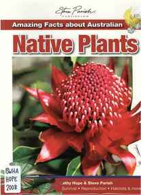
Publication, Amazing facts about Australian native plants (Hope, C. & Parish, S.), Archerfield, 2008, 2008
... Amazing facts about Australian native plants (Hope, C. & Parish, S.), Archerfield, 2008...Archerfield, Steve Parish Publishing Pty Ltd, Queensland, Australia...Beechworth Honey Archive 87 Ford Street Beechworth high-country Amazing facts about Australian native plants (Hope, C. & Parish, S.), Archerfield, 2008 Publication ... -
 Linton and District Historical Society Inc
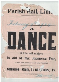
Poster, Grenville Standard Print Linton, Dance, Parish Hall, Linton, 1924, 1924
... Dance, Parish Hall, Linton, 1924...Used to advertise a dance in the Linton Parish Hall to raise funds for Hall improvements....Text: " Parish Hall, Linton / Febuary 9th 1924 / A / DANCE / Will be held as above, / In aid of the Japanese Fair, / To RAise Funds for Improvements to the Parish Hall...Entertainment Events Parish Hall Linton Dances S.B. Hannah Text: " Parish Hall, Linton / Febuary 9th 1924 / A / DANCE / Will be held as above, / In aid of the Japanese Fair, / To RAise Funds for Improvements to the Parish Hall. " White poster, black printing, blue crayon date, advertising a dance. ...Used to advertise a dance in the Linton Parish Hall to raise funds for Hall improvements.White poster, black printing, blue crayon date, advertising a dance.Text: " Parish Hall, Linton / Febuary 9th 1924 / A / DANCE / Will be held as above, / In aid of the Japanese Fair, / To RAise Funds for Improvements to the Parish Hall. "entertainment, events, parish hall linton, dances, s.b. hannah -
 Ringwood and District Historical Society
Book, The Anglican Parish of Christ Church, Heathmont - A History 1954 to 2004, 2004
... The Anglican Parish of Christ Church, Heathmont - A History 1954 to 2004...151 page book titled The Anglican Parish of Christ Church, Heathmont - A History 1954 to 2004. ...The Anglican Parish of Christ Church, Heathmont - A History 1954 to 2004...Ringwood and District Historical Society 125A Warrandyte Road Ringwood North melbourne The Anglican Parish of Christ Church, Heathmont - A History 1954 to 2004 151 page book titled The Anglican Parish of Christ Church, Heathmont - A History 1954 to 2004. ...151 page book titled The Anglican Parish of Christ Church, Heathmont - A History 1954 to 2004. Author - Robin Underwood (2 copies) +Additional Keywords: Underwood, RobinThe Anglican Parish of Christ Church, Heathmont - A History 1954 to 2004 -
Ringwood and District Historical Society
Newsletter, Holy Spirit Parish, North Ringwood weekly newsletters - 1985, 1985
... Holy Spirit Parish, North Ringwood weekly newsletters - 1985....The Holy Spirit: Weekly Service and Newsletter was given out weekly to the people of the parish....Holy Spirit Parish - Weekly Service and Newsletter....Ringwood and District Historical Society 125A Warrandyte Road Ringwood North melbourne The Holy Spirit: Weekly Service and Newsletter was given out weekly to the people of the parish. Holy Spirit Parish - Weekly Service and Newsletter. ...The Holy Spirit: Weekly Service and Newsletter was given out weekly to the people of the parish.Holy Spirit Parish - Weekly Service and Newsletter. -
 Peterborough History Group
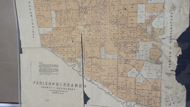
Map - Map of the Parish of Nirranda, Parish of Nirranda
... Parish of Nirranda...Map of the Parish including roads, names of landowners, location of schools etc in 1939...A3 size map of the Parish of Nirranda in 1939...Peterborough History Group Peterborough great-ocean-road Map of the Parish including roads, names of landowners, location of schools etc in 1939 nirranda Maps Parish map A3 size map of the Parish of Nirranda in 1939 Parish of Nirranda Map Map of the Parish of Nirranda ...Map of the Parish including roads, names of landowners, location of schools etc in 1939A3 size map of the Parish of Nirranda in 1939nirranda, maps, parish map -
 Bacchus Marsh & District Historical Society
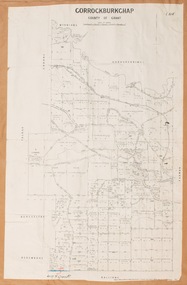
Map, Gorrockburkchap Parish Map, County of Grant c.1906
... Gorrockburkchap Parish Map, County of Grant c.1906...The locality of Rowsley is situated within this parish area....A single page paper map showing the parish plan for Gorrockburkchap in the County of Grant. ...The locality of Rowsley is situated within this parish area. Gorrockburkchap Parish Maps Rowsley Victoria Maps Bacchus Marsh Region Parish Plans A single page paper map showing the parish plan for Gorrockburkchap in the County of Grant. ...The parish of Gorrockburkchap (sometimes spelled Gorrockburkghap) lies to the west and south west of the township of Bacchus Marsh. The locality of Rowsley is situated within this parish area.A single page paper map showing the parish plan for Gorrockburkchap in the County of Grant. A cadastral map showing parish boundaries and land ownership The map is pasted into a bound volume containing 76 maps or plans in total. High resolution digital image stored on BMDHS computer network. gorrockburkchap parish maps, rowsley victoria maps, bacchus marsh region parish plans -
 Federation University Historical Collection
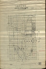
Plan - map, Ascot: Counties of Ripon and Talbot, 18/12/1920
... parish...Cadastral map showing parish boundaries and land ownership. "L5270"...Maps parishes located in Ascot area. Photo-Lithographed at the Dept. of Lands and Survey....Highlighted parish labelled, Mrs E.C.Sutherland....Highlighted parish labelled, Mrs E.C.Sutherland. Maps parishes located in Ascot area. ...Cadastral map showing parish boundaries and land ownership. "L5270"Maps parishes located in Ascot area. Photo-Lithographed at the Dept. of Lands and Survey.Highlighted parish labelled, Mrs E.C.Sutherland.parish, map, ascot, counties, e. c. sutherland, a. cameron, sweeney, w. j. clarke, mount hollowback, tourello, burrumbeet, glendaruel, dowling forest, a. j. mullett, w. j. butson, 1920, william coghill, chatham, chatham family collection, mrs e.c.sutherland. -
 Yarra Ranges Regional Museum
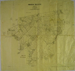
Map, H J Green, Acting Govt. Printer, Wandin Yallock, County of Evelyn (Parish Plan), c. 1910 - 1920
... Wandin Yallock, County of Evelyn (Parish Plan)...Parish Plan of Wandin Yallock. Location of Silvan Reservoir marked in ink on map....Parish Plan of Wandin Yallock. Location of Silvan Reservoir marked in ink on map. ...Wandin Yallock, County of Evelyn (Parish Plan) Map H J Green, Acting Govt. Printer ...Parish Plan of Wandin Yallock. Location of Silvan Reservoir marked in ink on map.Parish Plan of Wandin Yallock. Location of Silvan Reservoir marked in ink on map. wandin yallock, maps -
 Federation University Historical Collection
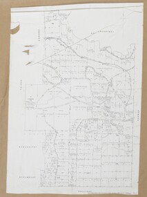
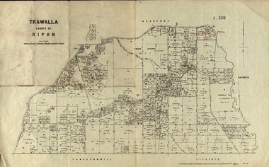
Parish Plan, Parish Plan of Trawalla in the Parish of Rippon, 1913, 28/4/1913
... Parish Plan of Trawalla in the Parish of Rippon, 1913...Parish Plan of Trawalla in the Parish of Rippon. ...Parish Plan of Trawalla in the Parish of Rippon, 1913 Parish Plan ...Trawalla is surrounded by Beaufort, Brewster, Lillirie, Yangerahwill and Eurambee.Parish Plan of Trawalla in the Parish of Rippon. trawala, ripon, westbrok, simson, mackenzie, mcarthur, wilson, nicholason, gibb, read, hayward, topper, foreman, bell, mcmillan, halpin, davis, goldsmith, trawalla pre-emptive right, butson, w.j. butson, m4471, w. read, c.a. foreman, j. simson, a. goldsmith, trawalla, g. topper -
 Port Melbourne Historical & Preservation Society
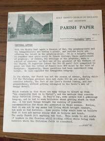
Document - Newsletter, Holy Trinity Anglican Church, Port Melbourne, Parish Paper, Nov 1973
... Parish Paper...Details information about the month of August 1974 for the Church and communicates information to parish goers...Monthly parish newsletter for the month of November 1973 for Holy Trinity Church, Port Melbourne...Details information about the month of August 1974 for the Church and communicates information to parish goers Religion - Anglican (Holy Trinity) Deaths and Funerals Donald Arthur LANGFORD Lewis J MULLIN Archibald H CARMICHAEL Glynn E G MARSHALL Phillip LAWSON William A WOODS Elsie J BAXTER Eliza M AANENSEN Ernest J McCOLL William H KILPATRICK Allan A CALLICK Emily NEWTON-SIMPSON Georgia Anita FENNESSY Robert Michael FLAHERTY Raymond Bede GRZONEK Christine Carol BATH Leanne ALDERMAN Returned Services League RSL Sandridge Trugo Club South Melbourne Football Club Albert Park Bowling Club Henry MOLLOY Ged MUSTON W H COFFEY George VINES Mrs MUSTON P BEDFORD C TUNCKS John MOORE Port Melbourne Bowling Club Port Melbourne Football Club Port Melbourne Cricket Club F McGORLICK Mrs McGORLICK Lions Club W STUCKBURY J T McLEOD D JONES G CECIL Yvonne Margaret KITCHEN F A W 'Skip' SHORT Monthly parish newsletter for the month of November 1973 for Holy Trinity Church, Port Melbourne Parish Paper Document Newsletter, Holy Trinity Anglican Church, Port Melbourne ...Newsletter was written for Port Melbourne Holy Trinity Church. Details information about the month of August 1974 for the Church and communicates information to parish goersMonthly parish newsletter for the month of November 1973 for Holy Trinity Church, Port Melbournereligion - anglican (holy trinity), deaths and funerals, donald arthur langford, lewis j mullin, archibald h carmichael, glynn e g marshall, phillip lawson, william a woods, elsie j baxter, eliza m aanensen, ernest j mccoll, william h kilpatrick, allan a callick, emily newton-simpson, georgia anita fennessy, robert michael flaherty, raymond bede grzonek, christine carol bath, leanne alderman, returned services league, rsl, sandridge trugo club, south melbourne football club, albert park bowling club, henry molloy, ged muston, w h coffey, george vines, mrs muston, p bedford, c tuncks, john moore, port melbourne bowling club, port melbourne football club, port melbourne cricket club, f mcgorlick, mrs mcgorlick, lions club, w stuckbury, j t mcleod, d jones, g cecil, yvonne margaret kitchen, f a w 'skip' short -
 Greensborough Historical Society
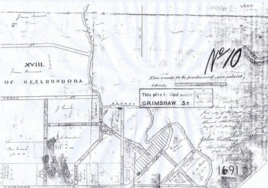
Plan, Parish Plan Map of Land North of Grimshaw Street, 11/12/1879
... Parish Plan Map of Land North of Grimshaw Street...Part of Parish plan of land north of Grimshaw Street bounded by the Plenty River. ...Photocopy of part of Parish plan of land north of Grimshaw Street bounded by the Plenty River. ...Parish Plan Map of Land North of Grimshaw Street Plan ...Part of Parish plan of land north of Grimshaw Street bounded by the Plenty River. Includes annotation signed by John Scotland and J. W. Britnell, dated Dec. 11th 1879.Photocopy of part of Parish plan of land north of Grimshaw Street bounded by the Plenty River. Includes annotation signed by John Scotland and J. W. Britnell, dated Dec. 11th 1879greensborough, grimshaw street greensborough, jonah britnell, john scotland -
 Bacchus Marsh & District Historical Society
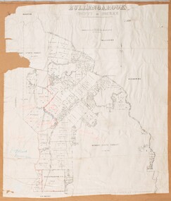
Map, Bullengarook Parish, County of Bourke
... Bullengarook Parish, County of Bourke ...An undated parish plan map for the parish of Bullegarook. ...A single page paper map showing the parish plan map for Bullengarook. This parish area contains the locality of Bullengarook and parts of the Wombat State Forest and is close to the town of Gisborne. ...Bacchus Marsh & District Historical Society Lerderderg Library Main Street Bacchus Marsh An undated parish plan map for the parish of Bullegarook. ...An undated parish plan map for the parish of Bullegarook. This parish area is close to the Bacchus Marsh district and borders some of the areas contained within the former Bacchus Marsh Shire and present day Moorabool Shire.A single page paper map showing the parish plan map for Bullengarook. This parish area contains the locality of Bullengarook and parts of the Wombat State Forest and is close to the town of Gisborne. A cadastral map showing land ownership. The map is not dated but a very similar map held by the State Library of Victoria is estimated to date from about 1927. The map is pasted into a bound volume containing 76 maps or plans in total. High resolution digital image stored on BMDHS computer network. bullengarook parish maps -
 Bacchus Marsh & District Historical Society
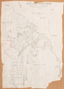
Map, Bullengarook Parish, County of Bourke
... Bullengarook Parish, County of Bourke ...An undated parish plan map for the parish of Bullegarook. ...A single page paper map showing the parish plan map for Bullengarook. This parish area contains the locality of Bullengarook and parts of the Wombat State Forest and is close to the town of Gisborne. ...Bacchus Marsh & District Historical Society Lerderderg Library Main Street Bacchus Marsh An undated parish plan map for the parish of Bullegarook. ...An undated parish plan map for the parish of Bullegarook. This parish area is close to the Bacchus Marsh district and borders some of the areas contained within the former Bacchus Marsh Shire and present day Moorabool Shire.A single page paper map showing the parish plan map for Bullengarook. This parish area contains the locality of Bullengarook and parts of the Wombat State Forest and is close to the town of Gisborne. A cadastral map showing land ownership. The map is not dated but a very similar map held by the State Library of Victoria is estimated to date from about 1927. The map is pasted into a bound volume containing 76 maps or plans in total. High resolution digital image stored on BMDHS computer network. bullengarook parish maps -
Glenelg Shire Council Cultural Collection
Postcard, H.A. George, CHRIST CHURCH CASTERTON, Christ Church Parish Hall, n.d
... CHRIST CHURCH CASTERTON, Christ Church Parish Hall...Upper ' Christ Church Casterton'; lower 'Christ Church Parish Hall'...George, photo' in border unDer top image 'Christ Church Parish Hall' bottom left corner of lower image Back: Green stamp 'F. ...Upper ' Christ Church Casterton'; lower 'Christ Church Parish Hall' CHRIST CHURCH CASTERTON, Christ Church Parish Hall Postcard Postcard H.A. ...Sourced from Casterton Town Hall (former Shire of Glenelg)Postcard, black and white. Two images. Upper ' Christ Church Casterton'; lower 'Christ Church Parish Hall'Front: 'Christ Church Casterton H.A. George, photo' in border unDer top image 'Christ Church Parish Hall' bottom left corner of lower image Back: Green stamp 'F. Henty Silvester 'Girrahween', Merino, Vic.' -
Whitehorse Historical Society Inc.
Map, Parish of Nunawading, 1939
... Parish of Nunawading... Parish of Nunawading, County of Bourke, Blackburn Wellington Avenue amended from Stanley Road...Plan of subdivision part of crown portions 81, 82 and 89, Parish of Nunawading, County of Bourke, Blackburn Wellington Avenue amended from Stanley Road...Whitehorse Historical Society Inc. 2-10 Deep Creek Road Mitcham melbourne Parish of Nunawading, County of Bourke, Blackburn Wellington Avenue amended from Stanley Road Street names Parish of Nunawading Blackburn Road Blackburn Wellington Avenue Blackburn Wolseley Crescent Blackburn Gordon Crescent Blackburn Clarke Street Blackburn Central Road Blackburn Plan of subdivision part of crown portions 81, 82 and 89, Plan of subdivision part of crown portions 81, 82 and 89, Parish of Nunawading, County of Bourke, Blackburn Wellington Avenue amended from Stanley Road Parish of Nunawading Map Map ...Plan of subdivision part of crown portions 81, 82 and 89,Plan of subdivision part of crown portions 81, 82 and 89, Parish of Nunawading, County of Bourke, Blackburn Wellington Avenue amended from Stanley RoadPlan of subdivision part of crown portions 81, 82 and 89, street names, parish of nunawading, blackburn road, blackburn, wellington avenue, blackburn, wolseley crescent, blackburn, gordon crescent, blackburn, clarke street, blackburn, central road, blackburn -
 Bacchus Marsh & District Historical Society
Map, Gorrockburkchap Parish Map, County of Grant
... Gorrockburkchap Parish Map, County of Grant...The locality of Rowsley is situated within this parish area....A single page paper map showing the parish plan for Gorrockburkchap in the County of Grant. ...The locality of Rowsley is situated within this parish area. Gorrockburkchap Parish Maps Rowsley Victoria Maps A single page paper map showing the parish plan for Gorrockburkchap in the County of Grant. ...The parish of Gorrockburkchap (sometimes spelled Gorrockburkghap) lies to the west and south west of the township of Bacchus Marsh. The locality of Rowsley is situated within this parish area.A single page paper map showing the parish plan for Gorrockburkchap in the County of Grant. The map is pasted into a bound volume containing 76 maps or plans in total. High resolution digital image stored on BMDHS computer network. gorrockburkchap parish maps, rowsley victoria maps