
Showing 5 items matching "parish of blackwood"
-
 Federation University Historical Collection
Document, License under Section 19 of "The Land Act 1869", 1875
... ...parish of blackwood...The area was in the County of Bourke, Parish of Blackwood. The area concerned is located on the Lerderderg River in the Wombat State Forest. ...The area was in the County of Bourke, Parish of Blackwood. The area concerned is located on the Lerderderg River in the Wombat State Forest. ...Full license and authority to enter and occupy Crown Land outlined was given to James Cowan. This was for a period of three years and subjected to conditions outlined on the document. The area was in the County of Bourke, Parish of Blackwood. The area concerned is located on the Lerderderg River in the Wombat State Forest. The fee for occupation was to be paid in advance by half-yearly payments to the Land Officer at Ballarat. The document signed on 1 July 1875 by William F Stawell, Acting Governor of Victoria.Thick pale blue paper. Hand written in ink Hand drawn map of land in questionDated 1 July 1875 Signed William F Stawelllicence, license, crown land, james cowan, county of bourke, parish of blackwood, lerderberg river, wombat state forest, william foster stawell, acting governor, land officer, ballarat -
 Bacchus Marsh & District Historical Society
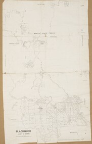
Map, Blackwood Parish Map, County of Bourke, 1892
... Blackwood Parish Map, County of Bourke, 1892... Parish Plan...Blackwood...A single page paper map showing the map for the Parish of Blackwood in the County of Bourke. A cadastral map showing parish boundaries and land ownership. ...Bacchus Marsh Region Parish Plans Blackwood Parish Plan Blackwood Parish Maps Photo-lithographed at the Department of Lands and Survey, Melbourne by T.F. ...A single page paper map showing the map for the Parish of Blackwood in the County of Bourke. A cadastral map showing parish boundaries and land ownership. The map is pasted into a bound volume containing 76 maps or plans in total. High resolution digital image stored on BMDHS computer network. Photo-lithographed at the Department of Lands and Survey, Melbourne by T.F. McGauran 14.7.92bacchus marsh region parish plans, blackwood parish plan, blackwood parish maps -
 Bacchus Marsh & District Historical Society
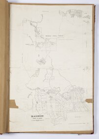
Map, Blackwood Parish Map, County of Bourke, 1905
... Blackwood Parish Map, County of Bourke, 1905... Parish Plan...Blackwood...A single page paper map showing the map for the Parish of Blackwood in the County of Bourke. A cadastral map showing parish boundaries and land ownership. ...Bacchus Marsh Region Parish Plans Blackwood Parish Plan Blackwood Parish Maps Photo-lithographed at the Department of Lands and Survey, Melbourne by T.F. ...A single page paper map showing the map for the Parish of Blackwood in the County of Bourke. A cadastral map showing parish boundaries and land ownership. The map is pasted into a bound volume containing 76 maps or plans in total. High resolution digital image stored on BMDHS computer network. Photo-lithographed at the Department of Lands and Survey, Melbourne by T.F. McGauran 21.7.05bacchus marsh region parish plans, blackwood parish plan, blackwood parish maps -
 Flagstaff Hill Maritime Museum and Village
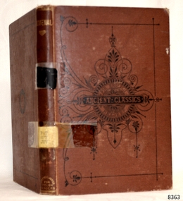
Book - Reference Book / Classics, Rev. W. Lucas Collins, Juvenal, 1872
... Educated at Rugby School and Jesus College, Oxford, he spent much of his life working as a parish priest in Wales and England. He was a frequent contributor to the prestigious Blackwood's Magazine and was close friends with the famous Victorian novelist Anthony Trollope (who actually wrote his novel Dr. ...Educated at Rugby School and Jesus College, Oxford, he spent much of his life working as a parish priest in Wales and England. He was a frequent contributor to the prestigious Blackwood's Magazine and was close friends with the famous Victorian novelist Anthony Trollope (who actually wrote his novel Dr. ...The subject book is a specific volume from a highly popular Victorian series called "Ancient Classics for English Readers." While Rev. W. Lucas Collins was the overarching editor of the entire 28-volume series (which explains why his name is prominently attached to it), the specific volume on Juvenal published in 1872 was actually written by a scholar named Edward Walford, M.A. The book is an introduction to Juvenal (Decimus Iunius Iuvenalis), a famous Roman poet active in the late 1st and early 2nd centuries AD. Juvenal is renowned for his Satires, which fiercely attacked the corruption, decadence, vice, and hypocrisy of Roman society under the Empire. In line with the rest of the series, this volume provides a translated, summarized, and curated overview of Juvenal's work. Because Juvenal's raw, unedited Latin can be incredibly explicit and vulgar, the Victorian authors heavily sanitized ("bowdlerized") the text, smoothing over the more scandalous elements to make his brilliant satire safe for a general English audience.Juvenal Author: Edward Walford, M.A. Editor:Rev. W. Lucas Collins Publisher: William Blackwood & Sons Date: 1872non-fictionThe subject book is a specific volume from a highly popular Victorian series called "Ancient Classics for English Readers." While Rev. W. Lucas Collins was the overarching editor of the entire 28-volume series (which explains why his name is prominently attached to it), the specific volume on Juvenal published in 1872 was actually written by a scholar named Edward Walford, M.A. The book is an introduction to Juvenal (Decimus Iunius Iuvenalis), a famous Roman poet active in the late 1st and early 2nd centuries AD. Juvenal is renowned for his Satires, which fiercely attacked the corruption, decadence, vice, and hypocrisy of Roman society under the Empire. In line with the rest of the series, this volume provides a translated, summarized, and curated overview of Juvenal's work. Because Juvenal's raw, unedited Latin can be incredibly explicit and vulgar, the Victorian authors heavily sanitized ("bowdlerized") the text, smoothing over the more scandalous elements to make his brilliant satire safe for a general English audience.flagstaff hil, warrnambool, flagstaff hill maritime museum, maritime museum, shipwreck coast, flagstaff hill maritime village, great ocean road, book, pattison collection, warrnambool library, warrnambool mechanics’ institute, ralph eric pattison, corangamite regional library service, warrnambool city librarian, mechanics’ institute library, victorian library board, warrnambool books and records, warrnambool children’s library, juvenal, lucas collins -
 Bacchus Marsh & District Historical Society
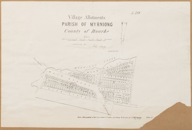
Map, Village allotments, Parish of Myrniong, County of Bourke
... Blackwood Street. An area marked as a reserve for a school can be seen between Hardy Street and Main Street. Myrniong Parish ...Myrniong is a village 9 kilometers west of Bacchus Marsh. Prior to 1863 the area was known as Blow's Flat. This map which was produced in 1903 and according to the catalogue record of this map held at the State Library of Victoria was based on an earlier map created in 1861. The early layout of streets for the village of Myrniong can be seen on this map. The streets shown are, Main Street, Hardy Street, Blow Street, Myrniong Street, Shuter Street, and Blackwood Street. An area marked as a reserve for a school can be seen between Hardy Street and Main Street.A single page paper map. A cadastral parish map of Myrniong in Victoria, showing numbered land allotments. Photo-lithographed at the Department of Lands & Survey, Melbourne, in 1903. Based on an original map created in 1861. The map is pasted into a bound volume containing 76 maps or plans in total. High resolution digital image stored on BMDHS computer network. Surveyed by John Hardy, Surveyor ; photo-lithographed at the Department of Lands & Survey, Melbourne by T.F. McGauran, 24.12.03myrniong parish plan, myrniong parish maps
