Showing 11 items matching "parkdale beach"
-
 Chelsea & District Historical Society Inc
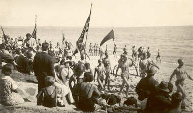
Photograph - Chelsea Life Saving Club, Competing in Life Saving Carnivals, 1930
... ...parkdale beach...P00538 the carnival was held at Chelsea Beach P01076 the carnival was held at Parkdale Beach...Chelsea Lifesaving Chelsea Beach parkdale beach Chelsea Life Saving Club Two black and white phots of Life-Saving Carnivals. ...Chelsea Life Saving Club was formed in 1917. The club competed in local and state carnivals across Victoria.Two black and white phots of Life-Saving Carnivals. P00538 the carnival was held at Chelsea Beach P01076 the carnival was held at Parkdale BeachChelsea Life Saving Clubchelsea, lifesaving, chelsea beach, parkdale beach -
 Chelsea & District Historical Society Inc
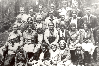
Photograph - Chelsea Life Saving Club, Members on a picnic, 1920's
... ...parkdale beach...Chelsea Lifesaving Chelsea Beach parkdale beach Hand written on back of photo: Mary Wilmott, Leon Touzell, Mrs Truebridge, B. ...Chelsea Life Saving Club was formed in 1917. The club competed in local and state carnivals across Victoria.Black and white phots of Chelsea Life-Saving Club members on a picnic. Hand written on back of photo: Mary Wilmott, Leon Touzell, Mrs Truebridge, B. Sangston, K. Frazer, J. Finch, Mr. McLaughlin, L. Truebridge, S. Finch, V. Wallace, D. Stamp, L. Wilmott, L. Mullen, Mrs Clough, E. Clough, L. Voight, B. Clough. Front row Left - Marjorie Truebridge, extreme right - Lois Truebridgechelsea, lifesaving, chelsea beach, parkdale beach -
 Ringwood and District Historical Society
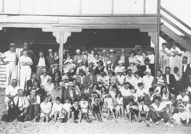
Photograph, Ringwood Masonic Lodge outing to Parkdale, 1931
... beach in front of pavilion. Black and white photograph Ringwood Masonic Lodge outing to Parkdale, 1931. ...Black and white photographImage shows group posing on the beach in front of pavilion. -
 City of Kingston
Photograph - Colour, Circa 1993
... Parkdale Edithvale is a suburb in the City of Kingston. It is located between Aspendale and Chelsea on the Port Phillip Bay and built within remnant areas of the Carrum Carrum swamp. The foreshore precinct comprises a wide sandy beach ...Edithvale is a suburb in the City of Kingston. It is located between Aspendale and Chelsea on the Port Phillip Bay and built within remnant areas of the Carrum Carrum swamp. The foreshore precinct comprises a wide sandy beach, with low sand dunes and numerous historic boat sheds. The suburb consists of older style dwellings and former holiday houses, combined with mid-century housing and newer homes. The large blocks are increasingly subdivided and the existing dwellings demolished to accommodate units and townhouses, thus changing the landscape of the area and reducing the tree canopy.The beachside suburb of Edithvale was previously part of the extensive Carrum Carrum Swamp. The area was once a source of fish and eels for the Mayone-Bulluk clan of the Bunurong people. Over time the area was drained and predominantly devoted to dairy farming and holiday houses. The farms were gradually sold and subdivided with a large number of homes built after World War II and in the 1960s. Edithvale is mainly residential with a shopping strip along Nepean Highway but little significant industry was ever established in the area apart from a plaster works and confectionary factory, both now closed.Aerial colour photograph of Edithvale as viewed from Alexandra Avenue in the north to Ella Grove Chelsea/Edithvale in the south. The area is built-up with residential housing and facilities including Edithvale Primary School, numerous churches and the Edithvale Railway station. Large sections depict the remnant Carrum Carrum swamp. Edithvale Common and the former "Duck Inn" (Melbourne Water/Friends of Edithvale Seaford Wetlands) can be seen. Edithvale Recreational reserve, the velodrome and Edithvale Public Golf Course are prominent. The image shows vacant land in the area now known as Aspendale Gardens and the newer residential section of Chelsea Heights is not developed. A bike path has been established to cover the secondary drain. The Golf Links Court residential development located off Hughes Avenue is a large vacant block.Yellow circular adhesive sticker on plastic Black ink (marker): * (asterisk) Black type on white adhesive sticker: P000108edithvale, aspendale, chelsea, carrum carrum swamp -
City of Kingston
Photograph - Colour, 6 March 1993
... Parkdale Edithvale is a suburb in the City of Kingston. It is located between Aspendale and Chelsea on the Port Phillip Bay and built within remnant areas of the Carrum Carrum swamp. The foreshore precinct comprises a wide sandy beach ...Edithvale is a suburb in the City of Kingston. It is located between Aspendale and Chelsea on the Port Phillip Bay and built within remnant areas of the Carrum Carrum swamp. The foreshore precinct comprises a wide sandy beach, with low sand dunes and numerous historic boat sheds. The suburb consists of older style dwellings and former holiday houses, combined with mid-century housing and newer homes. The large blocks are increasingly subdivided and the existing dwellings demolished to accommodate units and townhouses, thus changing the landscape of the area and reducing the tree canopy.The beachside suburb of Edithvale was previously part of the extensive Carrum Carrum Swamp. The area was once a source of fish and eels for the Mayone-Bulluk clan of the Bunurong people. Over time the area was drained and predominantly devoted to dairy farming and holiday houses. The farms were gradually sold and subdivided with a large number of homes built after World War II and in the 1960s. Edithvale is mainly residential with a shopping strip along Nepean Highway but little significant industry was ever established in the area apart from a plaster works and confectionary factory, both now closed.Laminated aerial colour photograph of Edithvale as viewed from Alexandra Avenue in the north to Ella Grove Chelsea/Edithvale in the south. regents Park Aspendale can be seen in the top left. The area is built-up with residential housing and facilities including Edithvale Primary School, numerous churches and the Edithvale Railway station. Large sections depict the remnant Carrum Carrum swamp. Edithvale Common and the former "Duck Inn" (Melbourne Water/Friends of Edithvale Seaford Wetlands) can be seen. Edithvale Recreational reserve, the valodrome and Edithvale Public Golf Course are prominent. The image shows vacant land in the area now known as Aspendale Gardens and the newer residential section of Chelsea Heights is not developed. A bike path has been established to cover the secondary drain. The Golf Links Court residential development located off Hughes Avenue is a large vacant block.Black type on white adhesive label: 6-3-93 Black type on white adhesive label: 25/9211, 6/3/93, 11.20 am Black type on white adhesive label: 9211 Yellow circular adhesive sticker Black pencil: 9211 6-3-93 arrow pointing Nedthvale, carrum carrum swamp, aspendale, chelsea -
 City of Kingston
Photograph - Digital image, c. 1914
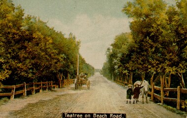
... City of Kingston Parkdale Library 96 Parkers Road, Parkdale Parkdale Digital copy of hand tinted image of two young girls playing on Beach Road, which is lined on either side by tea tree bushes. ...Digital copy of hand tinted image of two young girls playing on Beach Road, which is lined on either side by tea tree bushes. The girls have a white pony with them and a carriage is coming along the road behind them. -
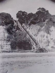 City of Kingston
Photograph - Black and white, Percy Fairlam, c. 1910
... City of Kingston Parkdale Library 96 Parkers Road, Parkdale Parkdale High cliffs required access to the beachfront to be made via a steep wooden staircase. Mentone Beach ...High cliffs required access to the beachfront to be made via a steep wooden staircase.Black and white image of the steep wooden staircase at Mentone Beach, leading down to the foreshore from the clifftops above. At the base of the staircase is a bicycle leaning against a foundation post.mentone, beach, staircase, access -
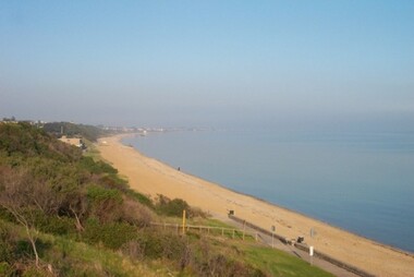 City of Kingston
Photograph - Digital image, Colour, City of Kingston (Graham Whitehead)
... Parkdale Colour image of Mentone foreshore looking towards Mordialloc. The natural environment of Kingston significantly impacted its development. The bay was a source of food and income, as well as a holiday destination. Mentone Beach ...Colour image of Mentone foreshore looking towards Mordialloc. The natural environment of Kingston significantly impacted its development. The bay was a source of food and income, as well as a holiday destination. Colour image of Mentone beach looking towards Mordialloc, with Mentone life saving club in distance.mentone, beach, environment -
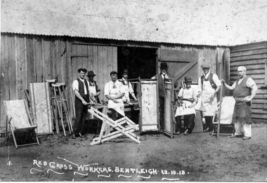 City of Kingston
Photograph - Black and white, Red Cross Workers Bentleigh, 1915
... City of Kingston Parkdale Library 96 Parkers Road, Parkdale Parkdale Red Cross Workers in Bentleigh are preparing stretchers and other convalescent aids for fighting men overseas. In the background wooden crutches are leaning against the shed wall and beach chairs are being repurposed in the front of the image. ...Red Cross Workers in Bentleigh are preparing stretchers and other convalescent aids for fighting men overseas. In the background wooden crutches are leaning against the shed wall and beach chairs are being repurposed in the front of the image.Black and white image of a group of eight men standing in front of a shed with several of the men wearing work aprons suggesting manual labour with crutches leaning against the shed and beach chairsHand written in red ink enclosed in a circle: A18 / 70%community, world war i, first world war, wwi, manual labour, repurposing, red cross, crutches, bentleigh -
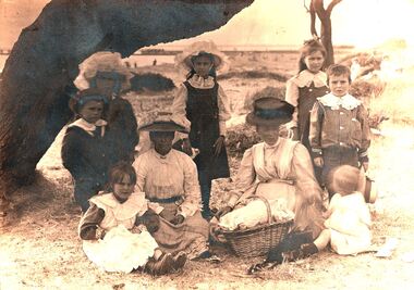 City of Kingston
Photograph - Digital image, Sepia, Squire family at Mordialloc Beach
... City of Kingston Parkdale Library 96 Parkers Road, Parkdale Parkdale Sepia image of the Squire family at Mordialloc Beach - Standing: Gordon, Olive, Myrtle, Lilian and Cyril, Front sitting: Hazel, Mrs Squire and Cousin Elizabeth and Bruce. ...Sepia image of the Squire family at Mordialloc Beach - Standing: Gordon, Olive, Myrtle, Lilian and Cyril, Front sitting: Hazel, Mrs Squire and Cousin Elizabeth and Bruce.Sepia image of a family with two women, with four boys and three girls sitting on grass under a tree with a picnic basketmordialloc, beach, squire, picnic -
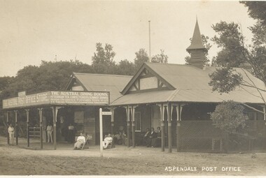 City of Kingston
Postcard - Postcard, Colour, Aspendale Post Office, c. 1920
... Parkdale Postcards began to be produced in Victoria from 1876. Between 1900 and 1920, picture postcards in Australia became an incredibly popular phenomenon. People could cheaply and easily send messages, without the formality of a letter, and they provided a cheap form of souvenir. Eventually, every event of significance was commemorated in some way with a postcard, and this led to the development of a ‘picture on one side and a message/stamp on the other’ postcard we are familiar with today. They were also a popular form of advertising. Aspendale Beach ...Postcards began to be produced in Victoria from 1876. Between 1900 and 1920, picture postcards in Australia became an incredibly popular phenomenon. People could cheaply and easily send messages, without the formality of a letter, and they provided a cheap form of souvenir. Eventually, every event of significance was commemorated in some way with a postcard, and this led to the development of a ‘picture on one side and a message/stamp on the other’ postcard we are familiar with today. They were also a popular form of advertising. Sepia toned postcard featuring the Aspendale Post Office with the Austral Dining Rooms, for afternoon teas and summer drinks, located beside it. There are several people sitting on bench seats and in deck chairs infront of the building. A wooden sign post in front of the building points toward the beach.aspendale, beach, leisure, post office