Showing 43 items matching "path construction"
-
 Heidelberg Golf Club
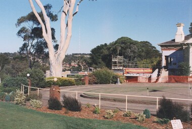
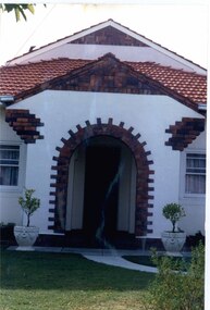
Photograph, Heidelberg Golf Club: Clubhouse renovations 1997-98 - Path and construction, 1997
... Heidelberg Golf Club: Clubhouse renovations 1997-98 - Path and construction...Heidelberg Golf Club: Clubhouse renovations 1997-98 - The path at rear of clubhouse and construction of Eaglemont Room...Heidelberg Golf Club 8 Main Road Lower Plenty 3093 Heidelberg Golf Club: Clubhouse renovations 1997-98 - The path at rear of clubhouse and construction of Eaglemont Room Clubhouse redevelopment 1998 HGC Clubhouse 1997 Basement Eaglemont Room Colour photograph and caption in album Heidelberg Golf Club: Clubhouse renovations 1997-98 - Path and construction Photograph Photograph ...Heidelberg Golf Club: Clubhouse renovations 1997-98 - The path at rear of clubhouse and construction of Eaglemont RoomColour photograph and caption in albumclubhouse redevelopment 1998, hgc clubhouse 1997, basement, eaglemont room -
 University of Melbourne, Burnley Campus Archives
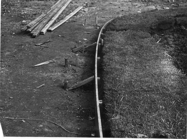
Photograph - Black and white print, E.M. Gibson, Creating New Path, 1947
... ...path construction...Black and white photograph of detail of construction of new path in front of Administration Building. ...University of Melbourne, Burnley Campus Archives 500 Yarra Boulevard Richmond melbourne construction administration building e. m. gibson collection path path construction 6/30 Black and white photograph of detail of construction of new path in front of Administration Building. ...Black and white photograph of detail of construction of new path in front of Administration Building. 6/30construction, administration building, e. m. gibson collection, path, path construction -
 Port Melbourne Historical & Preservation Society
Book - Borough of Sandridge, Officers of the Council, Asphalt Pavement Accounts, 1877 - 1960
... Columns record person liable for cost, location, measurement, cost of pavement and when paid. Path construction plan 1959 attached. Loose items are copies of notices sent to owner c1960s....Columns record person liable for cost, location, measurement, cost of pavement and when paid. Path construction plan 1959 attached. Loose items are copies of notices sent to owner c1960s. ...Asphalt Pavement Accounts book 1877- 1960. 'Borough of Sandridge' printed at top of pages. Columns record person liable for cost, location, measurement, cost of pavement and when paid. Path construction plan 1959 attached. Loose items are copies of notices sent to owner c1960s.'Asphalt Pavements Accounts' is embossed on the spine. The title given on the cover includes the words 'important records'engineering - roads streets lanes and footpaths, local government - town of port melbourne, local government - city of port melbourne, local government - borough of port melbourne, arthur victor heath, town clerks -
 Eltham District Historical Society Inc
Photograph, Tess Justine (Nillumbik Shire Council), Construction work on replacement of Murray's Bridge over the Diamond Creek, Eltham North, 31 Mar 2022
... path in the reserve. The old farmhouse was demolished in ca2014. Diamond Creek (Creek) diamond creek trail murrays bridge ‘Laurel Hill’ John Wright Murray Mary (Sweeney) Murra John Murray jnr James Murray John Langlands ‘Ihurst’ ‘Glen Park Estate’ Beard's Estate Franktonia Bonsack's Estate Glen Park Estate Glen Park Railway Station Born digital image (5) Construction work on replacement of Murray's Bridge over the Diamond Creek, Eltham North Photograph Photograph Tess Justine (Nillumbik Shire Council) ...Construction work on replacement of Murray's Bridge over the Diamond Creek on the Diamond Creek Trail Mary (Sweeney) Murray and John Wright Murray selected 80 acres, Lot C Section 16 and Lot 5 Section 17 Parish of Nillumbik, under an occupation license in 1866. John died in 1867 and freehold was granted to his son John in 1873. The farm was known as ‘Laurel Hill’. John Junior was an Eltham Shire councillor and sometime president from 1887 up until 1897. He added Lot A Section 16 to the farm in ca1888. John and his younger brother James arranged to rent/purchase Lot B Section 17, across Diamond Creek to the west, in ca1900. It appears that John and James farmed separately for a few years, with a new homestead built for James ad family on the high point of Lot B Section 17 in ca1910. John sold off Lot 5 Section 17 in 1912. When John died in 1912 James took over the land on both sides of the Diamond Creek. The old homestead on the west side of the Creek disappeared. A farm bridge over Diamond Creek from this period may have been located close to the northern boundary of the farm. John Langlands, owner of the farm known as ‘Ihurst’ on the west side of Diamond Creek to the south of the Murray’s land, died in 1907. In 1909 his land was then subdivided into 100 lots to become the ‘Glen Park Estate’. Other similar subdivisions of nineteenth century farms around Eltham in this period included the ‘Franktonia (or Beard’s) Estate’ to the northeast and ‘Bonsack’s Estate’ between Eltham and Greensborough. Soon after the opening of the railway extension line from Eltham to Hurstbridge in 1912, Glen Park and nearby residents including James Murray agitated for a railway station or siding to be located half-way between Eltham and Hurstbridge, so that the Glen Park residents who used the railway daily did not have to walk into the Eltham or Hurstbridge stations. Some believed Coleman’s Corner (opposite Edendale Farm) was an appropriate spot for the platform. James Murray was among those who thought the railway should be located on his land, closer to half-way between Eltham and Hurstbridge stations. The Railways Commissioners warned that the locals would have to fund these works themselves. The Glen Park Estate residents initially had difficulty accessing Eltham by road, with only an old low-level bridge over Diamond Creek at the south end of their estate. A new timber trestle bridge across the creek, now on Wattletree Road, was opened in 1915. Road access to the north was gained in 1927 when the new Murray’s Road, which crossed the Murray’s land, was built. Residents continued to agitate for a Glen Park station. By 1926 the Railways Commissioners’ preferred site was on the Murray’s land. They arranged an estimate of cost of a full-length platform. The estimate was too much for the locals, who in 1928 argued unsuccessfully for a shorter and hence cheaper platform. By 1929 Murray had agreed to donate the land, but the locals would still have to fund the works. Murray decided, unilaterally it would appear, to commence work on a timber trestle road bridge over Diamond Creek to link the new Murray Road to the proposed station. Late in 1929 he stopped work on the bridge, for reasons unknown, but started work again and completed the bridge in 1931. There is no further newspaper evidence of the campaign for the Glen Park station until 1939, when Murray and another local, Mr Maxwell, met the Railways Commissioner. The Glen Park locale now included 45 homes on the west side of the creek and 20 on the Eltham side. Most of the residents used the train every day. The Commissioner remained adamant that only a full-length platform could be built for safety reasons. It appears the campaign dissolved at this point. The increasing move to cars may have had an impact. There is no evidence of Murray’s bridge ever being connected to Murray’s Road, or of it having wide use for any purpose by locals. James Murray died in 1947 and the farm was taken over by his son James (Jim). Jim started to sell off parts of the farm in the 1980s, retaining a few acres around the ca1910 homestead and building a new house there. Recreation reserves were established along the creek. In ca1990 Murray’s bridge was renovated with steel girders as part of a bike/pedestrian path in the reserve. The old farmhouse was demolished in ca2014. Born digital image (5)diamond creek (creek), diamond creek trail, murrays bridge, ‘laurel hill’, john wright murray, mary (sweeney) murra, john murray jnr, james murray, john langlands, ‘ihurst’, ‘glen park estate’, beard's estate, franktonia, bonsack's estate, glen park estate, glen park railway station -
 Glen Eira Historical Society
Album - Album page, Normanby Road, Circa 1972
... From: Glen Eira Heritage Management Plan (1996) - Vol 2 by Andrew Ward and Associates The widening of Dandenong Road during the late 1980's has resulted in the destruction of the houses in the path of the roadworks and the construction of a high fence serving as a visual barrier between that thoroughfare and the remaining houses. ...From: Glen Eira Heritage Management Plan (1996) - Vol 2 by Andrew Ward and Associates The widening of Dandenong Road during the late 1980's has resulted in the destruction of the houses in the path of the roadworks and the construction of a high fence serving as a visual barrier between that thoroughfare and the remaining houses. ...This photograph is part of the Caulfield Historical Album 1972. This album was created in approximately 1972 as part of a project by the Caulfield Historical Society to assist in identifying buildings worthy of preservation. The album is related to a Survey the Caulfield Historical Society developed in collaboration with the National Trust of Australia (Victoria) and Caulfield City Council to identify historic buildings within the City of Caulfield that warranted the protection of a National Trust Classification. Principal photographer thought to be Trevor Hart, member of Caulfield Historical Society. Most photographs were taken between 1966-1972 with a small number of photographs being older and from unknown sources. All photographs are black and white except where stated, with 386 photographs over 198 pages. From: Glen Eira Heritage Management Plan (1996) - Vol 2 by Andrew Ward and Associates The widening of Dandenong Road during the late 1980's has resulted in the destruction of the houses in the path of the roadworks and the construction of a high fence serving as a visual barrier between that thoroughfare and the remaining houses. Where comparatively large villas once stood on spacious allotments, only "Wisteria" survives at No. 135 Normanby Road. Adopting forms and timber enrichment characteristic of the American Queen Anne style, it has this in common with the largely reconstructed timber villa at no. 11 Normanby Avenue and to a lesser extent, 746 Inkerman Road. Normanby Road retains its comparatively opulent Edwardian character in a mature landscaped setting with spacious gardens and mature planes parallel with the railway reserve which, on account of the low lying ground in its vicinity has a high embankment commencing on the alignment of Malvern Grove and continuing to Caulfield Station. The earliest villas are Edwardian. Page 148 of Photograph Album with one landscape photograph of a house on Normanby Road (not Street).Handwritten: Normanby St [top right] / 148 [bottom right]trevor hart, verandah, porch, bull nosed verandah, tower house, tower, stone fence, normanby road, wisteria, american queen anne style, queen anne style, 1890's, mayfield grove, normanby street, timber houses, caulfield north, house names, edwardian, edwardian style, gardens -
 Glen Eira Historical Society
Photograph, Beauville Avenue, 3, Murrumbeena, 2001
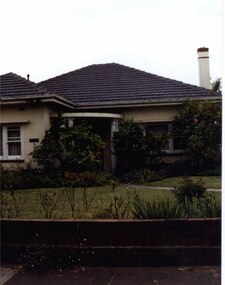
... The estate is distinguished by its aesthetic values, as is the earlier and comparable Hillcrest Estate, which are formed by a combination of restrained diversity in house styles, with the exception of no. 30 in the emerging International style, and by a landscaped garden environment. murrumbeena houses beauville avenue architectural styles 1930's inter war style a.v. jennings av jennings jennings brick houses beauville estate sir albert victor jennings a v jennings construction co beauville estate heritage area glen eira city council architectural features jennings group limited land subdivision gardens beauville historic area porches chimneys brick fences Colour photograph of cream coloured rendered house with unpainted brick features. Other features include a semi circular porch, tiled roof, chimney and a low unpainted brick fence in the foreground with small shrubs behind. A concrete path ...Originally labelled "Beauville Estate, Established 1936, Still Thriving 65 years on, 10th March 2001", the Beauville Estate Album contains colour photographs of houses in the Estate. They were taken around the time of the Beauville Estate’s 65th Heritage Celebration held on 10/03/2001 and donated to the Caulfield Historical Society shortly afterwards. Photographer Bev Baxter. City of Glen Eira’s Heritage Management Plan Vol 2 p79 (this is p84 of the pdf version) – HO12 Beauville Estate and environs, Murrumbeena: The Beauville Historic Area is important at the State level as the first large housing estate undertaken by the AV Jennings Construction Co, later Jennings Group Limited, Victoria’s largest home builder. It is important also as a very early estate development incorporating a range of features other than houses and including made roads, shops and recreation facilities. In this respect it was the forerunner of the comprehensively planned housing estate of the post war era. The estate is distinguished by its aesthetic values, as is the earlier and comparable Hillcrest Estate, which are formed by a combination of restrained diversity in house styles, with the exception of no. 30 in the emerging International style, and by a landscaped garden environment. Colour photograph of cream coloured rendered house with unpainted brick features. Other features include a semi circular porch, tiled roof, chimney and a low unpainted brick fence in the foreground with small shrubs behind. A concrete path crosses the lawn to the porch.murrumbeena, houses, beauville avenue, architectural styles, 1930's, inter war style, a.v. jennings, av jennings, jennings, brick houses, beauville estate, sir albert victor jennings, a v jennings construction co, beauville estate heritage area, glen eira city council, architectural features, jennings group limited, land subdivision, gardens, beauville historic area, porches, chimneys, brick fences -
 Glen Eira Historical Society
Photograph, Beauville Avenue, 8, Murrumbeena, 2001
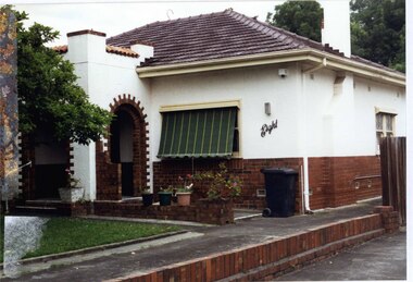
... The estate is distinguished by its aesthetic values, as is the earlier and comparable Hillcrest Estate, which are formed by a combination of restrained diversity in house styles, with the exception of no. 30 in the emerging International style, and by a landscaped garden environment. murrumbeena houses beauville avenue architectural styles 1930's inter war style a.v. jennings av jennings jennings brick houses beauville estate porches arches sir albert victor jennings rendered houses a v jennings construction co beauville estate heritage area glen eira city council architectural features jennings group limited land subdivision gardens beauville historic area chimneys brick fences striped awnings Colour photograph of white rendered house with unpainted brick features. Other features include a square enclosed porch with two decorative arched entrances with steps, tiled roof, green and yellow striped awning, the word "eight" written on the front of the house, concrete paths and driveway and a low unpainted brick fence beside the driveway. ...Originally labelled "Beauville Estate, Established 1936, Still Thriving 65 years on, 10th March 2001", the Beauville Estate Album contains colour photographs of houses in the Estate. They were taken around the time of the Beauville Estate’s 65th Heritage Celebration held on 10/03/2001 and donated to the Caulfield Historical Society shortly afterwards. Photographer Bev Baxter. See also 2104A-10.City of Glen Eira’s Heritage Management Plan Vol 2 p79 (this is p84 of the pdf version) – HO12 Beauville Estate and environs, Murrumbeena: The Beauville Historic Area is important at the State level as the first large housing estate undertaken by the AV Jennings Construction Co, later Jennings Group Limited, Victoria’s largest home builder. It is important also as a very early estate development incorporating a range of features other than houses and including made roads, shops and recreation facilities. In this respect it was the forerunner of the comprehensively planned housing estate of the post war era. The estate is distinguished by its aesthetic values, as is the earlier and comparable Hillcrest Estate, which are formed by a combination of restrained diversity in house styles, with the exception of no. 30 in the emerging International style, and by a landscaped garden environment. Colour photograph of white rendered house with unpainted brick features. Other features include a square enclosed porch with two decorative arched entrances with steps, tiled roof, green and yellow striped awning, the word "eight" written on the front of the house, concrete paths and driveway and a low unpainted brick fence beside the driveway.murrumbeena, houses, beauville avenue, architectural styles, 1930's, inter war style, a.v. jennings, av jennings, jennings, brick houses, beauville estate, porches, arches, sir albert victor jennings, rendered houses, a v jennings construction co, beauville estate heritage area, glen eira city council, architectural features, jennings group limited, land subdivision, gardens, beauville historic area, chimneys, brick fences, striped awnings -
 Glen Eira Historical Society
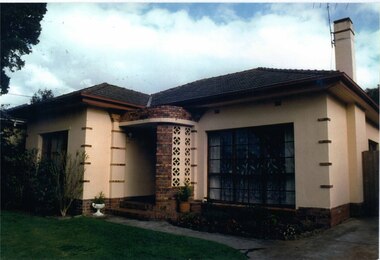
Photograph, Beauville Avenue, 16, Murrumbeena, 2001
... The estate is distinguished by its aesthetic values, as is the earlier and comparable Hillcrest Estate, which are formed by a combination of restrained diversity in house styles, with the exception of no. 30 in the emerging International style, and by a landscaped garden environment. murrumbeena houses beauville avenue architectural styles 1930's inter war style a.v. jennings av jennings jennings brick houses beauville estate porches sir albert victor jennings a v jennings construction co beauville estate heritage area glen eira city council architectural features jennings group limited land subdivision gardens beauville historic area brick features chimneys Colour photograph of light brown coloured rendered house with unpainted brick features. Other features include a curved wall porch, tiled roof, and concrete driveway and path ...Originally labelled "Beauville Estate, Established 1936, Still Thriving 65 years on, 10th March 2001", the Beauville Estate Album contains colour photographs of houses in the Estate. They were taken around the time of the Beauville Estate’s 65th Heritage Celebration held on 10/03/2001 and donated to the Caulfield Historical Society shortly afterwards. Photographer Bev Baxter. See also 2104A-19 which seems to be same property but with different colour and different larger plants in the right garden bed.City of Glen Eira’s Heritage Management Plan Vol 2 p79 (this is p84 of the pdf version) – HO12 Beauville Estate and environs, Murrumbeena: The Beauville Historic Area is important at the State level as the first large housing estate undertaken by the AV Jennings Construction Co, later Jennings Group Limited, Victoria’s largest home builder. It is important also as a very early estate development incorporating a range of features other than houses and including made roads, shops and recreation facilities. In this respect it was the forerunner of the comprehensively planned housing estate of the post war era. The estate is distinguished by its aesthetic values, as is the earlier and comparable Hillcrest Estate, which are formed by a combination of restrained diversity in house styles, with the exception of no. 30 in the emerging International style, and by a landscaped garden environment. Colour photograph of light brown coloured rendered house with unpainted brick features. Other features include a curved wall porch, tiled roof, and concrete driveway and path leading to the front porch. murrumbeena, houses, beauville avenue, architectural styles, 1930's, inter war style, a.v. jennings, av jennings, jennings, brick houses, beauville estate, porches, sir albert victor jennings, a v jennings construction co, beauville estate heritage area, glen eira city council, architectural features, jennings group limited, land subdivision, gardens, beauville historic area, brick features, chimneys -
 Glen Eira Historical Society
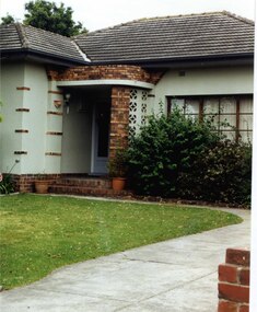
Photograph, Beauville Avenue, 16, Murrumbeena, 2001
... The estate is distinguished by its aesthetic values, as is the earlier and comparable Hillcrest Estate, which are formed by a combination of restrained diversity in house styles, with the exception of no. 30 in the emerging International style, and by a landscaped garden environment. murrumbeena houses beauville avenue architectural styles 1930's inter war style a.v. jennings av jennings jennings brick houses beauville estate porches sir albert victor jennings a v jennings construction co beauville estate heritage area glen eira city council architectural features jennings group limited land subdivision gardens beauville historic area brick features chimneys Colour photograph of light green rendered house with unpainted variegated brown brick features. Other features include a curved porch, tiled roof and concrete driveway and path ...Originally labelled "Beauville Estate, Established 1936, Still Thriving 65 years on, 10th March 2001", the Beauville Estate Album contains colour photographs of houses in the Estate. They were taken around the time of the Beauville Estate’s 65th Heritage Celebration held on 10/03/2001 and donated to the Caulfield Historical Society shortly afterwards. Photographer Bev Baxter. See also 2104A-18 which seems to be same property but with different colour and different smaller plants in the garden bed.City of Glen Eira’s Heritage Management Plan Vol 2 p79 (this is p84 of the pdf version) – HO12 Beauville Estate and environs, Murrumbeena: The Beauville Historic Area is important at the State level as the first large housing estate undertaken by the AV Jennings Construction Co, later Jennings Group Limited, Victoria’s largest home builder. It is important also as a very early estate development incorporating a range of features other than houses and including made roads, shops and recreation facilities. In this respect it was the forerunner of the comprehensively planned housing estate of the post war era. The estate is distinguished by its aesthetic values, as is the earlier and comparable Hillcrest Estate, which are formed by a combination of restrained diversity in house styles, with the exception of no. 30 in the emerging International style, and by a landscaped garden environment. Colour photograph of light green rendered house with unpainted variegated brown brick features. Other features include a curved porch, tiled roof and concrete driveway and path to the porch.murrumbeena, houses, beauville avenue, architectural styles, 1930's, inter war style, a.v. jennings, av jennings, jennings, brick houses, beauville estate, porches, sir albert victor jennings, a v jennings construction co, beauville estate heritage area, glen eira city council, architectural features, jennings group limited, land subdivision, gardens, beauville historic area, brick features, chimneys -
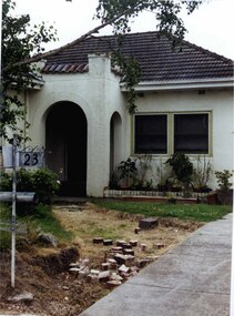 Glen Eira Historical Society
Photograph, Beauville Avenue, 23, Murrumbeena, 2001
... The estate is distinguished by its aesthetic values, as is the earlier and comparable Hillcrest Estate, which are formed by a combination of restrained diversity in house styles, with the exception of no. 30 in the emerging International style, and by a landscaped garden environment. murrumbeena houses beauville avenue architectural styles 1930's inter war style a.v. jennings av jennings jennings brick houses beauville estate porches arches letterboxes sir albert victor jennings a v jennings construction co beauville estate heritage area glen eira city council architectural features jennings group limited land subdivision gardens beauville historic area rendered houses Colour photograph of white rendered house with the concrete path removed from the front garden . ...Originally labelled "Beauville Estate, Established 1936, Still Thriving 65 years on, 10th March 2001", the Beauville Estate Album contains colour photographs of houses in the Estate. They were taken around the time of the Beauville Estate’s 65th Heritage Celebration held on 10/03/2001 and donated to the Caulfield Historical Society shortly afterwards. Photographer unknown.City of Glen Eira’s Heritage Management Plan Vol 2 p79 (this is p84 of the pdf version) – HO12 Beauville Estate and environs, Murrumbeena: The Beauville Historic Area is important at the State level as the first large housing estate undertaken by the AV Jennings Construction Co, later Jennings Group Limited, Victoria’s largest home builder. It is important also as a very early estate development incorporating a range of features other than houses and including made roads, shops and recreation facilities. In this respect it was the forerunner of the comprehensively planned housing estate of the post war era. The estate is distinguished by its aesthetic values, as is the earlier and comparable Hillcrest Estate, which are formed by a combination of restrained diversity in house styles, with the exception of no. 30 in the emerging International style, and by a landscaped garden environment. Colour photograph of white rendered house with the concrete path removed from the front garden . Other features include a semi enclosed porch with arched entrances and barrel tiled flat roof with four pillars. Property features also include a tiled roof, a concrete driveway and '23' on the adjacent mailbox. Bricks are scattered on dirt path in the front garden.murrumbeena, houses, beauville avenue, architectural styles, 1930's, inter war style, a.v. jennings, av jennings, jennings, brick houses, beauville estate, porches, arches, letterboxes, sir albert victor jennings, a v jennings construction co, beauville estate heritage area, glen eira city council, architectural features, jennings group limited, land subdivision, gardens, beauville historic area, rendered houses -
 Glen Eira Historical Society
Photograph, Beauville Avenue, 27, Murrumbeena, 2001
... The estate is distinguished by its aesthetic values, as is the earlier and comparable Hillcrest Estate, which are formed by a combination of restrained diversity in house styles, with the exception of no. 30 in the emerging International style, and by a landscaped garden environment. murrumbeena houses beauville avenue architectural styles 1930's inter war style a.v. jennings av jennings jennings brick houses beauville estate porches arches sir albert victor jennings a v jennings construction co beauville estate heritage area glen eira city council architectural features jennings group limited land subdivision gardens beauville historic area brick features outdoor ornaments rendered houses gables Colour photograph of the porch and surrounds for a white rendered house with unpainted variegated brown brick features and a later second storey addition. The porch has a wide decorative arched entrance, garden urns in front of the porch and a curved concrete path ...Originally labelled "Beauville Estate, Established 1936, Still Thriving 65 years on, 10th March 2001", the Beauville Estate Album contains colour photographs of houses in the Estate. They were taken around the time of the Beauville Estate’s 65th Heritage Celebration held on 10/03/2001 and donated to the Caulfield Historical Society shortly afterwards. Photographer unknown.City of Glen Eira’s Heritage Management Plan Vol 2 p79 (this is p84 of the pdf version) – HO12 Beauville Estate and environs, Murrumbeena: The Beauville Historic Area is important at the State level as the first large housing estate undertaken by the AV Jennings Construction Co, later Jennings Group Limited, Victoria’s largest home builder. It is important also as a very early estate development incorporating a range of features other than houses and including made roads, shops and recreation facilities. In this respect it was the forerunner of the comprehensively planned housing estate of the post war era. The estate is distinguished by its aesthetic values, as is the earlier and comparable Hillcrest Estate, which are formed by a combination of restrained diversity in house styles, with the exception of no. 30 in the emerging International style, and by a landscaped garden environment. Colour photograph of the porch and surrounds for a white rendered house with unpainted variegated brown brick features and a later second storey addition. The porch has a wide decorative arched entrance, garden urns in front of the porch and a curved concrete path through the lawn to the porch. murrumbeena, houses, beauville avenue, architectural styles, 1930's, inter war style, a.v. jennings, av jennings, jennings, brick houses, beauville estate, porches, arches, sir albert victor jennings, a v jennings construction co, beauville estate heritage area, glen eira city council, architectural features, jennings group limited, land subdivision, gardens, beauville historic area, brick features, outdoor ornaments, rendered houses, gables -
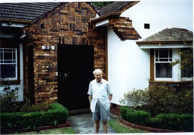 Glen Eira Historical Society
Photograph, Beauville Avenue, 39, Murrumbeena, 2001
... The estate is distinguished by its aesthetic values, as is the earlier and comparable Hillcrest Estate, which are formed by a combination of restrained diversity in house styles, with the exception of no. 30 in the emerging International style, and by a landscaped garden environment. murrumbeena houses beauville avenue architectural styles 1930's inter war style a.v. jennings av jennings jennings brick houses beauville estate porches bay windows sir albert victor jennings a v jennings construction co beauville estate heritage area glen eira city council architectural features jennings group limited land subdivision gardens beauville historic area rendered houses brick features cast iron work door sash windows people Colour photograph of porch area of white rendered house with unpainted variegated brown brick features. Features include the large brick porch with "39" on the wall and a decorative cast iron door, a tiled roof, hooded bay window, sash windows and a man standing on the path ...Originally labelled "Beauville Estate, Established 1936, Still Thriving 65 years on, 10th March 2001", the Beauville Estate Album contains colour photographs of houses in the Estate. They were taken around the time of the Beauville Estate’s 65th Heritage Celebration held on 10/03/2001 and donated to the Caulfield Historical Society shortly afterwards. Photographer unknown. City of Glen Eira’s Heritage Management Plan Vol 2 p79 (this is p84 of the pdf version) – HO12 Beauville Estate and environs, Murrumbeena: The Beauville Historic Area is important at the State level as the first large housing estate undertaken by the AV Jennings Construction Co, later Jennings Group Limited, Victoria’s largest home builder. It is important also as a very early estate development incorporating a range of features other than houses and including made roads, shops and recreation facilities. In this respect it was the forerunner of the comprehensively planned housing estate of the post war era. The estate is distinguished by its aesthetic values, as is the earlier and comparable Hillcrest Estate, which are formed by a combination of restrained diversity in house styles, with the exception of no. 30 in the emerging International style, and by a landscaped garden environment. Colour photograph of porch area of white rendered house with unpainted variegated brown brick features. Features include the large brick porch with "39" on the wall and a decorative cast iron door, a tiled roof, hooded bay window, sash windows and a man standing on the path leading to the porch. murrumbeena, houses, beauville avenue, architectural styles, 1930's, inter war style, a.v. jennings, av jennings, jennings, brick houses, beauville estate, porches, bay windows, sir albert victor jennings, a v jennings construction co, beauville estate heritage area, glen eira city council, architectural features, jennings group limited, land subdivision, gardens, beauville historic area, rendered houses, brick features, cast iron work door, sash windows, people -
 Glen Eira Historical Society
Photograph, Lindsay Avenue, 40, Murrumbeena, 2001
... The estate is distinguished by its aesthetic values, as is the earlier and comparable Hillcrest Estate, which are formed by a combination of restrained diversity in house styles, with the exception of no. 30 in the emerging International style, and by a landscaped garden environment. murrumbeena houses architectural styles 1930's inter war style a.v. jennings av jennings brick houses beauville estate porches lindsay avenue sir albert victor jennings a v jennings construction co beauville estate heritage area glen eira city council architectural features jennings group limited land subdivision gardens beauville historic area jennings arches chimneys brick features sash windows brick fences 40 Colour photograph of an unpainted variegated brown brick house. Other features include a porch with two arches and separate rectangular entry from the path ...Originally labelled "Beauville Estate, Established 1936, Still Thriving 65 years on, 10th March 2001", the Beauville Estate Album contains colour photographs of houses in the Estate. They were taken around the time of the Beauville Estate’s 65th Heritage Celebration held on 10/03/2001 and donated to the Caulfield Historical Society shortly afterwards. Photographer unknown. City of Glen Eira’s Heritage Management Plan Vol 2 p79 (this is p84 of the pdf version) – HO12 Beauville Estate and environs, Murrumbeena: The Beauville Historic Area is important at the State level as the first large housing estate undertaken by the AV Jennings Construction Co, later Jennings Group Limited, Victoria’s largest home builder. It is important also as a very early estate development incorporating a range of features other than houses and including made roads, shops and recreation facilities. In this respect it was the forerunner of the comprehensively planned housing estate of the post war era. The estate is distinguished by its aesthetic values, as is the earlier and comparable Hillcrest Estate, which are formed by a combination of restrained diversity in house styles, with the exception of no. 30 in the emerging International style, and by a landscaped garden environment. Colour photograph of an unpainted variegated brown brick house. Other features include a porch with two arches and separate rectangular entry from the path, arched side gate in a wall attached to the house at the side of the drive, feature work on all arches and chimney, white framed sash windows plus a long narrow white window to right of the porch, tiled roof, tall and wide chimney and low unpainted brick fence in the foreground with "40" on the brick pillar beside the drive.40murrumbeena, houses, architectural styles, 1930's, inter war style, a.v. jennings, av jennings, brick houses, beauville estate, porches, lindsay avenue, sir albert victor jennings, a v jennings construction co, beauville estate heritage area, glen eira city council, architectural features, jennings group limited, land subdivision, gardens, beauville historic area, jennings, arches, chimneys, brick features, sash windows, brick fences -
 Glen Eira Historical Society
Photograph, Gloucester Court, 1, Murrumbeena, 2001
... The estate is distinguished by its aesthetic values, as is the earlier and comparable Hillcrest Estate, which are formed by a combination of restrained diversity in house styles, with the exception of no. 30 in the emerging International style, and by a landscaped garden environment. murrumbeena houses architectural styles 1930's inter war style a.v. jennings av jennings jennings brick houses beauville estate gloucester court sir albert victor jennings a v jennings construction co beauville estate heritage area glen eira city council architectural features jennings group limited land subdivision gardens beauville historic area rendered houses chimneys house names sash windows cast iron work gates GLOUCESTER Colour photograph of a white rendered brick house. Other features include a tall chimney, sash windows, tiled roof, the word "GLOUCESTER" on the front of the house and a concrete path ...Originally labelled "Beauville Estate, Established 1936, Still Thriving 65 years on, 10th March 2001", the Beauville Estate Album contains colour photographs of houses in the Estate. They were taken around the time of the Beauville Estate’s 65th Heritage Celebration held on 10/03/2001 and donated to the Caulfield Historical Society shortly afterwards. Photographer unknown. City of Glen Eira’s Heritage Management Plan Vol 2 p79 (this is p84 of the pdf version) – HO12 Beauville Estate and environs, Murrumbeena: The Beauville Historic Area is important at the State level as the first large housing estate undertaken by the AV Jennings Construction Co, later Jennings Group Limited, Victoria’s largest home builder. It is important also as a very early estate development incorporating a range of features other than houses and including made roads, shops and recreation facilities. In this respect it was the forerunner of the comprehensively planned housing estate of the post war era. The estate is distinguished by its aesthetic values, as is the earlier and comparable Hillcrest Estate, which are formed by a combination of restrained diversity in house styles, with the exception of no. 30 in the emerging International style, and by a landscaped garden environment. Colour photograph of a white rendered brick house. Other features include a tall chimney, sash windows, tiled roof, the word "GLOUCESTER" on the front of the house and a concrete path leading to the entrance via the established garden. In the foreground are a cast iron gate and an unpainted tall brick pillar. GLOUCESTERmurrumbeena, houses, architectural styles, 1930's, inter war style, a.v. jennings, av jennings, jennings, brick houses, beauville estate, gloucester court, sir albert victor jennings, a v jennings construction co, beauville estate heritage area, glen eira city council, architectural features, jennings group limited, land subdivision, gardens, beauville historic area, rendered houses, chimneys, house names, sash windows, cast iron work gates -
 Glen Eira Historical Society
Photograph, Beauville Avenue, 33, Murrumbeena, 2001
... The estate is distinguished by its aesthetic values, as is the earlier and comparable Hillcrest Estate, which are formed by a combination of restrained diversity in house styles, with the exception of no. 30 in the emerging International style, and by a landscaped garden environment. murrumbeena houses architectural styles 1930's inter war style a.v. jennings av jennings jennings brick houses beauville estate porches sir albert victor jennings a v jennings construction co beauville estate heritage area glen eira city council architectural features jennings group limited land subdivision gardens beauville historic area brick features arches beauville avenue Colour photograph of a closeup view of an unpainted variegated brown brick porch belonging to a barely visible house. The enclosed porch features an arched entrance, patterned decorative brickwork and a lamp above the arch. A garden path ...Originally labelled "Beauville Estate, Established 1936, Still Thriving 65 years on, 10th March 2001", the Beauville Estate Album contains colour photographs of houses in the Estate. They were taken around the time of the Beauville Estate’s 65th Heritage Celebration held on 10/03/2001 and donated to the Caulfield Historical Society shortly afterwards. Photographer unknown. City of Glen Eira’s Heritage Management Plan Vol 2 p79 (this is p84 of the pdf version) – HO12 Beauville Estate and environs, Murrumbeena: The Beauville Historic Area is important at the State level as the first large housing estate undertaken by the AV Jennings Construction Co, later Jennings Group Limited, Victoria’s largest home builder. It is important also as a very early estate development incorporating a range of features other than houses and including made roads, shops and recreation facilities. In this respect it was the forerunner of the comprehensively planned housing estate of the post war era. The estate is distinguished by its aesthetic values, as is the earlier and comparable Hillcrest Estate, which are formed by a combination of restrained diversity in house styles, with the exception of no. 30 in the emerging International style, and by a landscaped garden environment. Colour photograph of a closeup view of an unpainted variegated brown brick porch belonging to a barely visible house. The enclosed porch features an arched entrance, patterned decorative brickwork and a lamp above the arch. A garden path curves out either side of the porch and its garden.murrumbeena, houses, architectural styles, 1930's, inter war style, a.v. jennings, av jennings, jennings, brick houses, beauville estate, porches, sir albert victor jennings, a v jennings construction co, beauville estate heritage area, glen eira city council, architectural features, jennings group limited, land subdivision, gardens, beauville historic area, brick features, arches, beauville avenue -
 Glen Eira Historical Society
Photograph, Dalny Road, 23, Murrumbeena, 2001
... The estate is distinguished by its aesthetic values, as is the earlier and comparable Hillcrest Estate, which are formed by a combination of restrained diversity in house styles, with the exception of no. 30 in the emerging International style, and by a landscaped garden environment. murrumbeena houses architectural styles 1930's inter war style a.v. jennings av jennings jennings brick houses beauville estate dalny road porches brick features sir albert victor jennings a v jennings construction co beauville estate heritage area glen eira city council architectural features jennings group limited land subdivision gardens beauville historic area chimneys sash windows brick fences cast iron work gates rendered houses 23 Colour photograph of a cream rendered brick house with unpainted decorative variegated brown brick features including on the porch and chimney. Other features include tiled roof, sash windows, concrete path ...Originally labelled "Beauville Estate, Established 1936, Still Thriving 65 years on, 10th March 2001", the Beauville Estate Album contains colour photographs of houses in the Estate. They were taken around the time of the Beauville Estate’s 65th Heritage Celebration held on 10/03/2001 and donated to the Caulfield Historical Society shortly afterwards. Photographer unknown. City of Glen Eira’s Heritage Management Plan Vol 2 p79 (this is p84 of the pdf version) – HO12 Beauville Estate and environs, Murrumbeena: The Beauville Historic Area is important at the State level as the first large housing estate undertaken by the AV Jennings Construction Co, later Jennings Group Limited, Victoria’s largest home builder. It is important also as a very early estate development incorporating a range of features other than houses and including made roads, shops and recreation facilities. In this respect it was the forerunner of the comprehensively planned housing estate of the post war era. The estate is distinguished by its aesthetic values, as is the earlier and comparable Hillcrest Estate, which are formed by a combination of restrained diversity in house styles, with the exception of no. 30 in the emerging International style, and by a landscaped garden environment. Colour photograph of a cream rendered brick house with unpainted decorative variegated brown brick features including on the porch and chimney. Other features include tiled roof, sash windows, concrete path, garden pots, established garden and a low unpainted lighter variegated brown brick fence in the foreground with '23' on the left hand pillar beside the black cast iron work gate. 23murrumbeena, houses, architectural styles, 1930's, inter war style, a.v. jennings, av jennings, jennings, brick houses, beauville estate, dalny road, porches, brick features, sir albert victor jennings, a v jennings construction co, beauville estate heritage area, glen eira city council, architectural features, jennings group limited, land subdivision, gardens, beauville historic area, chimneys, sash windows, brick fences, cast iron work gates, rendered houses -
 Halls Gap & Grampians Historical Society
Map - Coloured
... The mining Department had paid L300 for its construction and, when completed, the track was "three miles and 30 chains in length, the side cuttings at the narrowest part being 10 feet between" and "the watercourses which cross the track at various points" having been "filled up with rocks rolled down the sides of the hills, and consequently there can be no damage caused by bushfires which destroyed the former wooden bridges erected on the old track to Wakeham's saw-mill, the remains of which are still to be seen at the side of the diggings" The article goes on to further describe the track as one which "can with ease travel with a two horse conveyance either up or down" and that the workmen engaged in the construction of the track would be attending "a ball that night at McKeon's farm near the mouth of the gap to celebrate the successful completion of the undertaking". 1900s At what time the bridle path was extended beyond Valley Gap to the Wartook basin on the Mt. ...The mining Department had paid L300 for its construction and, when completed, the track was "three miles and 30 chains in length, the side cuttings at the narrowest part being 10 feet between" and "the watercourses which cross the track at various points" having been "filled up with rocks rolled down the sides of the hills, and consequently there can be no damage caused by bushfires which destroyed the former wooden bridges erected on the old track to Wakeham's saw-mill, the remains of which are still to be seen at the side of the diggings" The article goes on to further describe the track as one which "can with ease travel with a two horse conveyance either up or down" and that the workmen engaged in the construction of the track would be attending "a ball that night at McKeon's farm near the mouth of the gap to celebrate the successful completion of the undertaking". 1900s At what time the bridle path was extended beyond Valley Gap to the Wartook basin on the Mt. ...Background on Bridle Path up Stony Creek Gorge Pre 1840 C. B. Hall, squatter on Mokepilly Run 1841-1842, first European to discover the Fyans Creek valley, the entrance of which became known as Hall's Gap. He later recorded that he followed a number of tracks which he assumed had been made by the Aboriginies and described one as "leading up a wild romantic glen and over on to the source of the Glenelg River". This could well have been the route taken up Stony Creek gorge by the first timber-cutters in this part of the Grampians to the saddle between the Wonderland and Mt. Difficult ranges known as Valley Gap 1850s/60s Timber cutters and shingle splitters were reported to be moving into the eastern side of the Grampians and by the mid 1860s there were a number of families connected to the supplying of timber to Pleasant Creek living in the "Hall's Gap ranges". John Wakeham, the first store owner in Pleasant Creek in 1854, established a timer-mill in upper Stony Creek Gorge in the late 1850s. Wakeham is credited for the clearing and levelling of the first bridle-path up the gorge. 1870s By the mid 1870s the track had been extended over Valley Gap to the Victoria Forest (the upper region of the Victoria Valley). McKeon's bullock team was known to have hauled red gum from the Valley to Stawell in the late 1870s and the 1880s. 1880s In 1887 an article in the Pleasant Creek news describes the Stony Creek Gorge track as "being a ledge alongside the mountain range, formed in the early days with the aid of earth and timber, along which the bullock teams used to travel to Horsham and plains of the Wimmera beyond." 1890s Gold was discovered in the catchment area of Stony Creek and by the end of the 1890s a new track was built from "near the junction of Fyan's and Stony Creeks, up the gorge to the diggings settlement. The mining Department had paid L300 for its construction and, when completed, the track was "three miles and 30 chains in length, the side cuttings at the narrowest part being 10 feet between" and "the watercourses which cross the track at various points" having been "filled up with rocks rolled down the sides of the hills, and consequently there can be no damage caused by bushfires which destroyed the former wooden bridges erected on the old track to Wakeham's saw-mill, the remains of which are still to be seen at the side of the diggings" The article goes on to further describe the track as one which "can with ease travel with a two horse conveyance either up or down" and that the workmen engaged in the construction of the track would be attending "a ball that night at McKeon's farm near the mouth of the gap to celebrate the successful completion of the undertaking". 1900s At what time the bridle path was extended beyond Valley Gap to the Wartook basin on the Mt. Difficult Range has not yet been determined. However, it is known that, by the turn of the century, people were travelling between Halls Gap and the caretakers' residence at Wartook Reservoir along what was now known as the "Bluff Road. Wartook's embankment had been constructed in 1887 and at that time there was already a track from Rosebrook Station homestead (near the present day Wartook Pottery) to the reservoir. Philip Rose owned both Rosebrook and Wartook Stations from the mid 1840s to the late 1850s and had regularly leased the Wartook basin to Cobb & Co. to rest horses there. 1920s Following the war of 1914-1918, tourism really took off in the Grampians, and Halls Gap rapidly grew. People would travel as far as they could on the many tracks then hike to the many lookouts being discovered by local tour guides. This led to the need for access across the range so that horse riders and the increasing number of vehicles could travel between Horsham and Halls Gap. To this end, the Bluff Road was improved and extended on 1929 and at its opening in March, 1930, by Lady Somers it was renamed the Mt. Victory Road.Map of Mt Victory Road and othersaccess routes, mt victory rd, bridle path, roads -
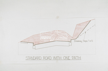 Eltham District Historical Society Inc
Slide, Cross Section, Standard Road with one path; Shire of Eltham, c.1972, 1972
... Eltham District Historical Society Inc 728 Main Rd Eltham melbourne Design Guide, Eltham Shire Council, Infrastructure, Road construction, shire of eltham 35 mm colour positive transparency Mount - Agfacolor Service (Blue) Cross Section, Standard Road with one path; Shire of Eltham, c.1972 Slide ...35 mm colour positive transparency Mount - Agfacolor Service (Blue)design guide, eltham shire council, infrastructure, road construction, shire of eltham -
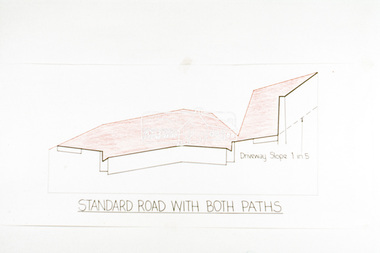 Eltham District Historical Society Inc
Slide, Cross Section, Standard Road with two paths; Shire of Eltham, c.1972, 1972
... Eltham District Historical Society Inc 728 Main Rd Eltham melbourne design guide, eltham shire council, infrastructure, road construction, shire of eltham 35 mm colour positive transparency Mount - Agfacolor Service (Blue) Cross Section, Standard Road with two paths; Shire of Eltham, c.1972 Slide ...35 mm colour positive transparency Mount - Agfacolor Service (Blue)design guide, eltham shire council, infrastructure, road construction, shire of eltham -
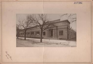 Bendigo Historical Society Inc.
Photograph - HANRO COLLECTION: PHOTO OF HANRO KNITTING MILLS
... construction with doors either end. Four steps lead up to the doors and 10 windows along the front facing Hargreaves Street. A path...construction with doors either end. Four steps lead up to the doors and 10 windows along the front facing Hargreaves Street. A path ...BHS CollectionPhoto of Hanro Knitting Mills: On Cream card with 6cm border is a photo of the Hanro Knitting Mills building in Hargreaves Street Bendigo. Of brick construction with doors either end. Four steps lead up to the doors and 10 windows along the front facing Hargreaves Street. A path with open gutters of blue stone block runs along the front of the building. Out from the path are three established trees on the nature strip. The view in the photo also shows part of the right hand side of the building. On the top written in black ink is *MP386*. Box 116ABartlett Bros., Bendigohanro, clothing, hanro knitting mill building, hanro knitting mill building. hargreaves street. -
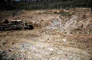 Bendigo Historical Society Inc.
Slide - RALPH BIRRELL COLLECTION: EIG SCHOOL, 1966
... Construction of Latrobe Uni. C1969. Bendigo Institute of Technology, Engineering School, Applied Science. Workman with grader, he has been grading the site ready for paths, gardens etc. ...Construction of Latrobe Uni. C1967. Bendigo Institute of Technology Engineering School Applied Science. Workman grader grading site paths gardens etc. ...EIG School - Ralph Birrell Collection. - Construction of Latrobe Uni. C1969. Bendigo Institute of Technology, Engineering School, Applied Science. Workman with grader, he has been grading the site ready for paths, gardens etc. Markings Made in Australia, MAY 69MKodakeducation, tertiary, latrobe university bendigo, eig school - ralph birrell collection. - construction of latrobe uni. c1967. bendigo institute of technology, engineering school, applied science. workman grader, grading site paths, gardens etc. -
 Bendigo Historical Society Inc.
Slide - RALPH BIRRELL COLLECTION: EIG SCHOOL, c1966
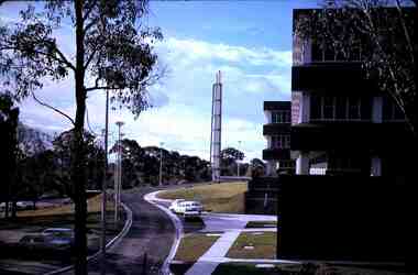
... Construction of Latrobe Uni. C1966, 1977. Bendigo Institute of Technology, Engineering School, Applied Science. View across the front of the university showing paths, driveway, car parking and cooling tower....Construction of Latrobe Uni. C1966 1977. Bendigo Institute of Technology Engineering School Applied Science. View front university paths ...EIG School - Ralph Birrell Collection. - Construction of Latrobe Uni. C1966, 1977. Bendigo Institute of Technology, Engineering School, Applied Science. View across the front of the university showing paths, driveway, car parking and cooling tower.Kodakeducation, tertiary, latrobe university bendigo, eig school - ralph birrell collection. - construction of latrobe uni. c1966, 1977. bendigo institute of technology, engineering school, applied science. view front university paths driveway, car parking cooling tower -
 Bendigo Historical Society Inc.
Slide - RALPH BIRRELL COLLECTION: EIG SCHOOL, c1966
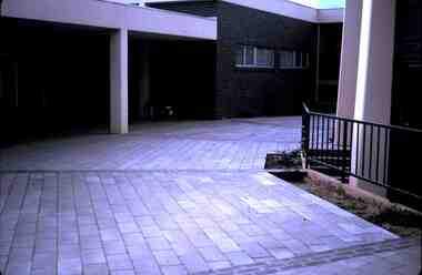
... Construction of Latrobe Uni. C1966... 1972. Bendigo Institute of Technology... Engineering School... Applied Science. path...Construction of Latrobe Uni. C1966, 1972. Bendigo Institute of Technology, Engineering School, Applied Science. View of the path...Construction of Latrobe Uni. C1966 1972. Bendigo Institute of Technology Engineering School Applied Science. path leading between buildings Kodak EIG School - Ralph Birrell Collection. - Construction of Latrobe Uni. ...EIG School - Ralph Birrell Collection. - Construction of Latrobe Uni. C1966, 1972. Bendigo Institute of Technology, Engineering School, Applied Science. View of the path leading up into or between the buildings.Kodakeducation, tertiary, latrobe university bendigo, eig school - ralph birrell collection. - construction of latrobe uni. c1966, 1972. bendigo institute of technology, engineering school, applied science. path leading between buildings -
The Ed Muirhead Physics Museum
JEOL 100CX Transmission Electron Microscope
... A Cutaway Transmission electron microscope allows detail of the inner construction and beam path to be viewed....The Ed Muirhead Physics Museum Level 2, The School of Physics, David Caro Building (192) Corner of Elgin and Swanston Streets The University of Melbourne Parkville melbourne A Cutaway Transmission electron microscope allows detail of the inner construction and beam path to be viewed. JEOL 100CX Transmission Electron Microscope ...A Cutaway Transmission electron microscope allows detail of the inner construction and beam path to be viewed. -
 Ballarat Tramway Museum
Photograph - View of Wendouree Parade north end, c1977
... Shows the roadside nature of gardens area at the time - long grass and before the construction of a gutter and paths. Possibly taken at the same time as item 9642....Shows the roadside nature of gardens area at the time - long grass and before the construction of a gutter and paths. Possibly taken at the same time as item 9642. ...Photograph from the window of a tram (possibly No. 28) looking along the BTPS track from St Aidans Drive with another tramcar in the distance. Shows the roadside nature of gardens area at the time - long grass and before the construction of a gutter and paths. Possibly taken at the same time as item 9642.Yields information about Wendouree Parade near St Aidans Drive.Black and white print on Kodak paper.tramcars, trams, btps, tram 26, tram 28, st aidans drive, wendouree parade -
 Surrey Hills Historical Society Collection
Photograph, Union Road looking west from the steeple of Holy Trinity Church, 1922, 1922
... construction, across Union Road to the north-west. In the foreground immature street trees can be seen and an original telephone pole with white insulators. The street has formed paths...construction, across Union Road to the north-west. In the foreground immature street trees can be seen and an original telephone pole with white insulators. The street has formed paths ...At the edge of the church roof and on the horizon is 'The Knoll' on the corner of Union Road and Wandsworth Road. To the left of this is 297 Mont Albert Road, home of the Michael Parer family and further left is "Quamby", home of the Sherar family. This is easily recognised by the square viewing tower located on the west wing of the house. The Sherar family owned 'Quamby' from 1900 until 1925, when it became Mosgiel Private Hospital. Norman Carter took many photos of Surrey Hills and Mont Albert in the 1920s; many associated with events and activities of the Church of England. Black and white photo of taken from the steeple of Holy Trinity Church, during its construction, across Union Road to the north-west. In the foreground immature street trees can be seen and an original telephone pole with white insulators. The street has formed paths and bluestone kerb and channelling. holy trinity anglican church, union road, the knoll, quamby, street trees, telegraph and light poles, mosgiel hospital -
 University of Melbourne, Burnley Campus Archives
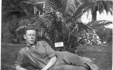
Photograph - Black and white prints and negatives, Athol Shmith Studio Illustrative Photography, Les Provan Collection, 1922-1946
... construction. (7) 4 men standing next to Dahlias judging them. (8) Student walking along path between ponds and Pavilion....construction early 1946. Mrs. Kneen & children." (7) On reverse,"Judges in trial Dahlias Burnley 1943. Left to right Jack Reid, Castell, Charlie Stone, Geo. Russ, Norm Scable." (8)) On reverse, "June Bishop-student," and, "Athol Shmith Studio Illustrative Photography 125 Collins Street, Melbourne C.1. Cent. 27. No 10383 Position J." Note by E.B. Littlejohn 4 March 1992, "June Bishop standing at junction of paths...Jack Allen (centre) was later on staff as an Instructor. (6) Mrs Kneen and two children walking through the Administration Building under construction. (7) 4 men standing next to Dahlias judging them. (8) Student walking along path between ponds and Pavilion. ...Photographs donated by James Leslie (Les) Provan. (1) Note by T.H. Kneen 6 May 1992, "James Leslie Provan went to Melbourne University - graduated B. Agr. Sc-and later 1942 became Principal Burnley and 1946 Principal Dookie Agricultural College."Black and white photographs and negatives. (1) 2 photographs and negative. Les Provan reclining on the ground infront of a Kentia palm and part of the pavilion behind. (2) Includes negative. Les Provan and another male student seated on the lawn. (3) Note attached, "English lad, Fred ?, ?, Jack Allen." 4 male students seated on the lawn in front of the Pavilion. (4) Male student with calf. (5) 3 male students squatting on the lawn in front of the pavilion, one holding a football. Note by E.B. Littlejohn 6 May 1992, "Student on left is R. Fred Gillespie ? Jack Allen (centre) was later on staff as an Instructor. (6) Mrs Kneen and two children walking through the Administration Building under construction. (7) 4 men standing next to Dahlias judging them. (8) Student walking along path between ponds and Pavilion.(1) On reverse, "Student Les Provan 1922 &1923. Dux 1923. Background is Kentia Palm & the Chemistry classroom of the old Pavilion. (2) On reverse, "Les Provan & ? 1923." (3) On reverse, "Group of male students 1922 or 1923." (4) On reverse, "? name an English lad, student 1922 or '23." (5) On reverse, "The Football Team L to R. Fred---Jack Allen & ? 1923." (6) On reverse, "The new College building in course of construction early 1946. Mrs. Kneen & children." (7) On reverse,"Judges in trial Dahlias Burnley 1943. Left to right Jack Reid, Castell, Charlie Stone, Geo. Russ, Norm Scable." (8)) On reverse, "June Bishop-student," and, "Athol Shmith Studio Illustrative Photography 125 Collins Street, Melbourne C.1. Cent. 27. No 10383 Position J." Note by E.B. Littlejohn 4 March 1992, "June Bishop standing at junction of paths one of which leads to main entrance to Pavilion."les provan, kentia palm, chemistry classroom, pavilion, james leslie provan, dookie agricultural college, jack allen, r. fred gillespie, dahlias, jack reid, castell, charlie stone, geo. russ, norm scable, june bishop, cows, student group 1922-1923, football team 1922-1923, administration building construction, mrs kneen, kneen children, athol shmith, garden view, dux, calf, main building construction -
 University of Melbourne, Burnley Campus Archives
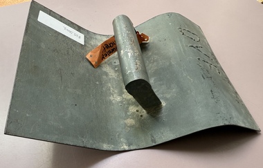
Tool - Concrete tool, Curb Concrete tool
... University of Melbourne, Burnley Campus Archives 500 Yarra Boulevard Richmond melbourne Roads and paths throughout Burnley were concreted and this tool was used to shape the curbs Construction Burnley campus paths curbs curbs curb tool artifact DVF Curved shaped metal tool with handle to create the shape of curbs in wet concrete. ...Roads and paths throughout Burnley were concreted and this tool was used to shape the curbsCurved shaped metal tool with handle to create the shape of curbs in wet concrete.DVFconstruction, burnley campus, paths curbs, curbs, curb tool, artifact -
 Wodonga & District Historical Society Inc
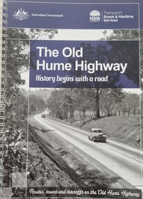
Book - The Old Hume Highway - History begins with a Road, 2014
... path in 1824. Much of the original highway followed their overland route wherever the landscape allowed. The road connected many small communities and rural properties, although in many parts was narrow and unsurfaced. Over the following years alterations and some deviations occurred with changing transport needs and heavier traffic loads. One of these deviations was completed in 1933 at Table Top north of Albury between Ettamogah and Mullengandra due to the construction ...The Hume Highway was officially named in 1928, when both the New South Wales and Victorian governments agreed to give the unified inland route between Sydney and Melbourne the name, honouring explorer Hamilton Hume who, with William Hovell, first found the overland path in 1824. Much of the original highway followed their overland route wherever the landscape allowed. The road connected many small communities and rural properties, although in many parts was narrow and unsurfaced. Over the following years alterations and some deviations occurred with changing transport needs and heavier traffic loads. One of these deviations was completed in 1933 at Table Top north of Albury between Ettamogah and Mullengandra due to the construction of the Hume Weir which flooded the existing highway. Gradually sections of the road were converted to a dual carriageway. In 1961 the first modern freeway-standard, four-lane section was completed in Victoria at Craigieburn. The Hume Highway was also rerouted in Albury to avoid the town centre. Many major bypasses and duplications in New South Wales were completed throughout the 1980s and 1990s. In 1994 the last section of the Hume Highway in Victoria was duplicated with the completion of the Wangaratta bypass. The Albury-Wodonga bypass was opened in 2007 and in 2013 the final section, the Holbrook Bypass in NSW, was opened to traffic on August 7, completing the full Sydney-Melbourne dual carriageway link. In the course of this gigantic engineering achievement, many small, historic towns throughout Victoria and New South Wales were bypassed and often forgotten by passing commuters in a rush to reach their destination. This publication includes maps and information about the sites and landmarks in these towns. It encourages travellers to venture of the modern highway and rediscover the Old Hume Highway and the stories it holds about out past.A spiral bound volume of 122 pages including maps, photographs and illustrations prepared as a travel guide to the Old Hume Highway. It includes a Foreword by Peter FitzSimons.The Hume Highway was officially named in 1928, when both the New South Wales and Victorian governments agreed to give the unified inland route between Sydney and Melbourne the name, honouring explorer Hamilton Hume who, with William Hovell, first found the overland path in 1824. Much of the original highway followed their overland route wherever the landscape allowed. The road connected many small communities and rural properties, although in many parts was narrow and unsurfaced. Over the following years alterations and some deviations occurred with changing transport needs and heavier traffic loads. One of these deviations was completed in 1933 at Table Top north of Albury between Ettamogah and Mullengandra due to the construction of the Hume Weir which flooded the existing highway. Gradually sections of the road were converted to a dual carriageway. In 1961 the first modern freeway-standard, four-lane section was completed in Victoria at Craigieburn. The Hume Highway was also rerouted in Albury to avoid the town centre. Many major bypasses and duplications in New South Wales were completed throughout the 1980s and 1990s. In 1994 the last section of the Hume Highway in Victoria was duplicated with the completion of the Wangaratta bypass. The Albury-Wodonga bypass was opened in 2007 and in 2013 the final section, the Holbrook Bypass in NSW, was opened to traffic on August 7, completing the full Sydney-Melbourne dual carriageway link. In the course of this gigantic engineering achievement, many small, historic towns throughout Victoria and New South Wales were bypassed and often forgotten by passing commuters in a rush to reach their destination. This publication includes maps and information about the sites and landmarks in these towns. It encourages travellers to venture of the modern highway and rediscover the Old Hume Highway and the stories it holds about out past.old hume highway, hume highway, travel guide hume highway, \ -
 University of Melbourne, Burnley Campus Archives
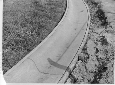
Photograph - Black and white print, E.M. Gibson, Detail of Curb Construction, 1947
... University of Melbourne, Burnley Campus Archives 500 Yarra Boulevard Richmond melbourne administration building e. m. gibson collection path curbing 6/31 Black and white photograph of detail of curbing around new path in front of Administration Building. Detail of Curb Construction Photograph Black and white print E.M. ...Black and white photograph of detail of curbing around new path in front of Administration Building. 6/31administration building, e. m. gibson collection, path, curbing