Showing 6 items matching "peanut farm"
-
 Port Melbourne Historical & Preservation Society
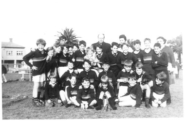
Photograph - St Joseph's Catholic Primary School, Premiers, Peanut Farm Reserve, St Kilda, 1960s
... St Joseph's Catholic Primary School, Premiers, Peanut Farm Reserve, St Kilda...B&W photo St Josephs Catholic Primary Premiers 1967, taken at the Peanut Farm Reserve in St Kilda. The parish priest is at centre back, coach Phyl NICHOLLS at back right....Photograph St Joseph's Catholic Primary School, Premiers, Peanut Farm Reserve, St Kilda ...B&W photo St Josephs Catholic Primary Premiers 1967, taken at the Peanut Farm Reserve in St Kilda. The parish priest is at centre back, coach Phyl NICHOLLS at back right.phyl nicholls, education - primary schools, sport - australian rules football, st josephs catholic primary school, religion - roman catholic church (st josephs) -
 St Kilda Historical Society
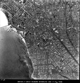
Photograph - Photo map, 17/01/1951
... ...Peanut farm...For correlation with a current map, and access to other historical photo maps of Victoria, see the Historic Photo-Maps Index published by the Department of Environment, Land, Water and Planning at https://services.land.vic.gov.au/DELWPmaps/historical-photomaps/ St Kilda St Kilda botanical gardens Peanut farm Elwood 1951 Point Ormond Elwood canal St Kilda Beach 1414-21 538 Run 19 Lens 12" Melbourne Metropolitan 12150 17.1.51 M586 Black and white aerial photograph Photograph Photo map ...One of a series of photo-maps produced for the Department of Crown Lands and Survey (1857-1983). For correlation with a current map, and access to other historical photo maps of Victoria, see the Historic Photo-Maps Index published by the Department of Environment, Land, Water and Planning at https://services.land.vic.gov.au/DELWPmaps/historical-photomaps/Black and white aerial photograph1414-21 538 Run 19 Lens 12" Melbourne Metropolitan 12150 17.1.51 M586st kilda, st kilda botanical gardens, peanut farm, elwood, 1951, point ormond, elwood canal, st kilda beach -
 St Kilda Historical Society
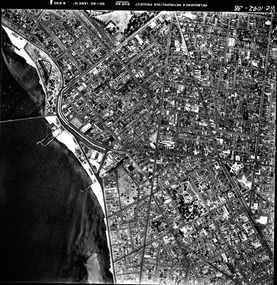
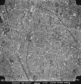
Photograph - Photo map, 30/01/1960
... ...Peanut farm...For correlation with a current map, and access to other historical photo maps of Victoria, see the Historic Photo-Maps Index published by the Department of Environment, Land, Water and Planning at https://services.land.vic.gov.au/DELWPmaps/historical-photomaps/ St Kilda St Kilda beach St Kilda pier Catani gardens 1960 St Kilda Botanical Gardens Peanut farm Vic 1092-38 Melbourne & Metropolitan Project Run 22 30.1.60 Lens 10" 8.200 Black and white aerial photograph Photograph Photo map ...One of a series of photo-maps produced for the Department of Crown Lands and Survey (1857-1983). For correlation with a current map, and access to other historical photo maps of Victoria, see the Historic Photo-Maps Index published by the Department of Environment, Land, Water and Planning at https://services.land.vic.gov.au/DELWPmaps/historical-photomaps/Black and white aerial photographVic 1092-38 Melbourne & Metropolitan Project Run 22 30.1.60 Lens 10" 8.200st kilda, st kilda beach, st kilda pier, catani gardens, 1960, st kilda botanical gardens, peanut farm -
 St Kilda Historical Society
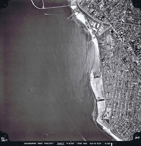
Photograph - Photo map, 14/12/1963
... ...Peanut farm...For correlation with a current map, and access to other historical photo maps of Victoria, see the Historic Photo-Maps Index published by the Department of Environment, Land, Water and Planning at https://services.land.vic.gov.au/DELWPmaps/historical-photomaps/ St Kilda Peanut farm Point Ormond St Kilda marina St Kilda pier 1963 Vic 1807 Melbourne 1963 Project Run 17 14.12.63 Lens 205 152,70 M/M 5.150 34 Black and white aerial photograph Photograph Photo map ...One of a series of photo-maps produced for the Department of Crown Lands and Survey (1857-1983). For correlation with a current map, and access to other historical photo maps of Victoria, see the Historic Photo-Maps Index published by the Department of Environment, Land, Water and Planning at https://services.land.vic.gov.au/DELWPmaps/historical-photomaps/Black and white aerial photographVic 1807 Melbourne 1963 Project Run 17 14.12.63 Lens 205 152,70 M/M 5.150 34st kilda, peanut farm, point ormond, st kilda marina, st kilda pier, 1963 -
 St Kilda Historical Society
Photograph - Photo map, 12/04/1966
... ...Peanut farm...For correlation with a current map, and access to other historical photo maps of Victoria, see the Historic Photo-Maps Index published by the Department of Environment, Land, Water and Planning at https://services.land.vic.gov.au/DELWPmaps/historical-photomaps/ St Kilda St Kilda East Balaclava Toorak Amadale Caulfield South Yarra St Kilda Botanical gardens Peanut farm 1966 Vic 1933 Melbourne 1966 Project Run 12 12.4.66 Lens 122 151.75MM 9.800 154 Black and white aerial photograph Photograph Photo map ...One of a series of photo-maps produced for the Department of Crown Lands and Survey (1857-1983). For correlation with a current map, and access to other historical photo maps of Victoria, see the Historic Photo-Maps Index published by the Department of Environment, Land, Water and Planning at https://services.land.vic.gov.au/DELWPmaps/historical-photomaps/Black and white aerial photographVic 1933 Melbourne 1966 Project Run 12 12.4.66 Lens 122 151.75MM 9.800 154st kilda, st kilda east, balaclava, toorak, amadale, caulfield, south yarra, st kilda botanical gardens, peanut farm, 1966 -
 St Kilda Historical Society
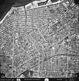
Photograph - Photo map, Department of Crown Lands and Survey (1857-1983), 22/01/1970
... ...Peanut farm...For correlation with a current map, and access to other historical photo maps of Victoria, see the Historic Photo-Maps Index published by the Department of Environment, Land, Water and Planning at https://services.land.vic.gov.au/DELWPmaps/historical-photomaps/ St Kilda St Kilda East St Kilda Marina Elwood Elwood canal Elsternwick Park Point Ormond Balaclava MC Moran Reserve Ripponlea St Kilda Botanical Gardens Peanut farm 1970 Vic 2358 Department of Crown Lands and Survey Victoria,.© Melbourne 1970 Project Run 42E 22.1.70 5,100 ASL 77 Black and white aerial photograph Photograph Photo map Department of Crown Lands and Survey (1857-1983) ...One of a series of photo-maps produced for the Department of Crown Lands and Survey (1857-1983). For correlation with a current map, and access to other historical photo maps of Victoria, see the Historic Photo-Maps Index published by the Department of Environment, Land, Water and Planning at https://services.land.vic.gov.au/DELWPmaps/historical-photomaps/Black and white aerial photographVic 2358 Department of Crown Lands and Survey Victoria,.© Melbourne 1970 Project Run 42E 22.1.70 5,100 ASL 77st kilda, st kilda east, st kilda marina, elwood, elwood canal, elsternwick park, point ormond, balaclava, mc moran reserve, ripponlea, st kilda botanical gardens, peanut farm, 1970