Showing 83 items matching "pedestrian crossing"
-
 Ringwood and District Historical Society
Report, Ringwood Bypass and Suda-Larissa Avenue pedestrian crossing reports. 1992, 14-Jul-92
... Ringwood Bypass and Suda-Larissa Avenue pedestrian crossing reports. 1992...Brief notes and a locality map issued to local householders about a meeting to discuss the Suda-Larissa Avenue pedestrian crossing....Brief notes and a locality map issued to local householders about a meeting to discuss the Suda-Larissa Avenue pedestrian crossing. Report comprising three white A4 pages: two with typed notes and one of Ringwood Bypass notes. ...Ringwood and District Historical Society 125A Warrandyte Road Ringwood North melbourne Brief notes and a locality map issued to local householders about a meeting to discuss the Suda-Larissa Avenue pedestrian crossing. Brief notes and a locality map issued to local householders about a meeting to discuss the Suda-Larissa Avenue pedestrian crossing. ...Brief notes and a locality map issued to local householders about a meeting to discuss the Suda-Larissa Avenue pedestrian crossing.Brief notes and a locality map issued to local householders about a meeting to discuss the Suda-Larissa Avenue pedestrian crossing. Report comprising three white A4 pages: two with typed notes and one of Ringwood Bypass notes. +Additional Keywords: Adams, Chris -
 Ringwood and District Historical Society
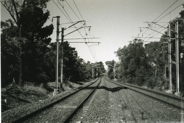
Photograph-B&W, Joan Walker, East Ringwood 2000-Pedestrian crossing over the railway line looking towards Croydon, 2000
... East Ringwood 2000-Pedestrian crossing over the railway line looking towards Croydon...East Ringwood 2000-Pedestrian crossing over the railway line looking towards Croydon- B&W Photo from Album 6501...Ringwood and District Historical Society 125A Warrandyte Road Ringwood North melbourne East Ringwood 2000-Pedestrian crossing over the railway line looking towards Croydon- B&W Photo from Album 6501 East Ringwood 2000-Pedestrian crossing over the railway line looking towards Croydon Photograph-B&W Joan Walker ...East Ringwood 2000-Pedestrian crossing over the railway line looking towards Croydon- B&W Photo from Album 6501 -
 Ringwood and District Historical Society
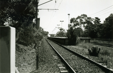
Photograph-B&W, Joan Walker, East Ringwood 2000-Pedestrian crossing (near Lois St) looking towards the Station, 2000
... East Ringwood 2000-Pedestrian crossing (near Lois St) looking towards the Station...East Ringwood 2000-Pedestrian crossing (near Lois St) looking towards the Station- B&W Photo from Album 6501...Ringwood and District Historical Society 125A Warrandyte Road Ringwood North melbourne East Ringwood 2000-Pedestrian crossing (near Lois St) looking towards the Station- B&W Photo from Album 6501 East Ringwood 2000-Pedestrian crossing (near Lois St) looking towards the Station Photograph-B&W Joan Walker ...East Ringwood 2000-Pedestrian crossing (near Lois St) looking towards the Station- B&W Photo from Album 6501 -
 Greensborough Historical Society
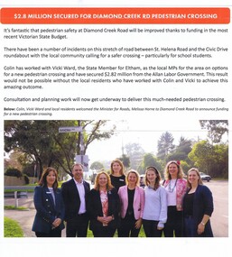
Article - Newsletter Clipping, Colin Brooks, $2.8 million secured for Diamond Creek Road pedestrian crossing, May 2024
... $2.8 million secured for Diamond Creek Road pedestrian crossing...Article from Brooksy's Briefing about funding for a pedestrian crossing between St. Helena Road and the Civic Drive roundabout in Greensborough....Greensborough Historical Society 34A Glenauburn Road Lower Plenty Lower Plenty melbourne Article from Brooksy's Briefing about funding for a pedestrian crossing between St. Helena Road and the Civic Drive roundabout in Greensborough. st helena road greensborough civic drive greensborough Colin Brooks Newsletter article, text with colour image $2.8 million secured for Diamond Creek Road pedestrian crossing Article Newsletter Clipping Colin Brooks ...Article from Brooksy's Briefing about funding for a pedestrian crossing between St. Helena Road and the Civic Drive roundabout in Greensborough.Newsletter article, text with colour imagest helena road greensborough, civic drive greensborough, colin brooks -
 Greensborough Historical Society
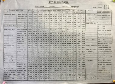
Poster - Diagram, Pedestrian crossing traffic densities, by City of Heidelberg, 1958_
... Pedestrian crossing traffic densities, by City of Heidelberg...Readings were taken at 34 pedestrian crossings in the Heidelberg and Greensborough areas, of pedestrians and vehicles at hourly intervals between 8 am and 6 pm on four Fridays in August and September 1958...Readings were taken at 34 pedestrian crossings in the Heidelberg and Greensborough areas, of pedestrians and vehicles at hourly intervals between 8 am and 6 pm on four Fridays in August and September 1958 traffic heidelberg greensborough Table of pedestrian counts, text and numeric values Pedestrian crossing traffic densities, by City of Heidelberg Poster Diagram City of Heidelberg ...Readings were taken at 34 pedestrian crossings in the Heidelberg and Greensborough areas, of pedestrians and vehicles at hourly intervals between 8 am and 6 pm on four Fridays in August and September 1958Table of pedestrian counts, text and numeric valuestraffic, heidelberg, greensborough -
 Whitehorse Historical Society Inc.
Photograph, Pedestrian Crossing & Nunawading Railway Station, 1/06/2009
... Pedestrian Crossing & Nunawading Railway Station...This photograph is looking over the south side of the intersection in Springvale, to the pedestrian crossing and the Railway Station. The shopping centre is on the right hand side. ...See NP 3545 to NP3567 for the complete set of photographs Pedestrian Crossing & Nunawading Railway Station Photograph Photograph ...One of a collection of photographs taken of the Nunawading Railway Station prior to the lowering of the railway line and building of the new railway station on the western side of Springvale Road so that the Springvale Road Rail Crossing can be eliminated.Black & white photograph of the precinct surrounding the Nunawading Station and the Springvale Road Railway crossing. This photograph is looking over the south side of the intersection in Springvale, to the pedestrian crossing and the Railway Station. The shopping centre is on the right hand side. See NP 3545 to NP3567 for the complete set of photographsnunawading railway station, springvale road nunawading, redevelopment of railway line/springvale road. -
 Ringwood and District Historical Society
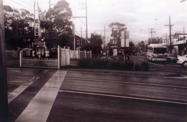
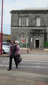
Photograph, North Ringwood Shopping Centre pedestrian crossing, Warrandyte Road, North Ringwood, near Dickson Crescent - July, 1981
... North Ringwood Shopping Centre pedestrian crossing, Warrandyte Road, North Ringwood, near Dickson Crescent - July, 1981....Black and white photograph of shops. Pedestrian lights and crossing outside shops....Ringwood and District Historical Society 125A Warrandyte Road Ringwood North melbourne Black and white photograph of shops. Pedestrian lights and crossing outside shops. North Ringwood Shopping Centre pedestrian crossing, Warrandyte Road, North Ringwood, near Dickson Crescent - July, 1981. ...Black and white photograph of shops. Pedestrian lights and crossing outside shops. -
 Ringwood and District Historical Society
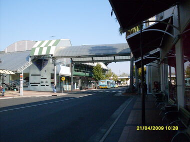
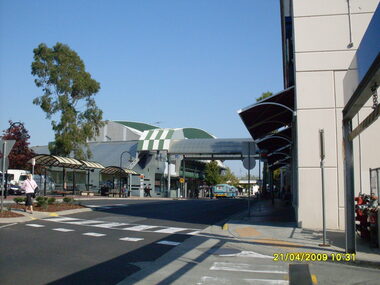
Photograph, Eastland access road looking west, on 21 April 2009. Showing library on left, shops on right and car overpass. Also Ventura buses and pedestrian crossing to Eastland
... Also Ventura buses and pedestrian crossing to Eastland....Also Ventura buses and pedestrian crossing to Eastland. Photograph ...Ron Brons photographic study of Ringwood. -
 Ringwood and District Historical Society
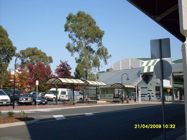
Photograph, Looking along Eastland access road looking west, on 21 April 2009. Showing pedestrian crossing
... Looking along Eastland access road looking west, on 21 April 2009. Showing pedestrian crossing....Looking along Eastland access road looking west, on 21 April 2009. Showing pedestrian crossing. Photograph ...Ron Brons photographic study of Ringwood. -
 Ringwood and District Historical Society
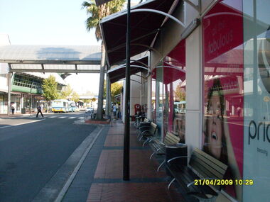
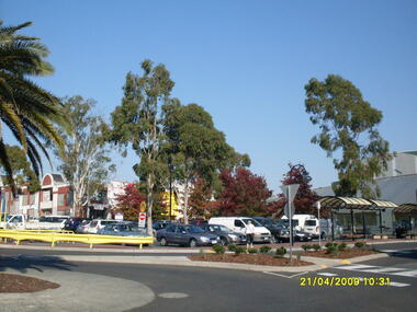
Photograph, Looking along Eastland access road towards the west, on 21 April 2009. Showing pedestrian crossing to south car park
... Looking along Eastland access road towards the west, on 21 April 2009. Showing pedestrian crossing to south car park....Looking along Eastland access road towards the west, on 21 April 2009. Showing pedestrian crossing to south car park. Photograph ...Ron Brons photographic study of Ringwood. -
 Ringwood and District Historical Society
Photograph, Looking along Eastland access road towards the south-west, on 21 April 2009. Showing pedestrian crossing to south car park and shops
... Looking along Eastland access road towards the south-west, on 21 April 2009. Showing pedestrian crossing to south car park and shops....Looking along Eastland access road towards the south-west, on 21 April 2009. Showing pedestrian crossing to south car park and shops. Photograph ...Ron Brons photographic study of Ringwood. -
 Ringwood and District Historical Society
Photograph, Looking along former Adelaide Street, from the access road roundabout, towards the south, on 21 April 2009. Showing pedestrian crossing to south car park and shops
... Looking along former Adelaide Street, from the access road roundabout, towards the south, on 21 April 2009. Showing pedestrian crossing to south car park and shops....Looking along former Adelaide Street, from the access road roundabout, towards the south, on 21 April 2009. Showing pedestrian crossing to south car park and shops. Photograph ...Ron Brons photographic study of Ringwood. -
 Ringwood and District Historical Society
Photograph, Looking from the Eastland access road roundabout, towards the south-east, on 21 April 2009. Showing pedestrian crossing and car park
... Looking from the Eastland access road roundabout, towards the south-east, on 21 April 2009. Showing pedestrian crossing and car park....Looking from the Eastland access road roundabout, towards the south-east, on 21 April 2009. Showing pedestrian crossing and car park. Photograph ...Ron Brons photographic study of Ringwood. -
 Greensborough Historical Society
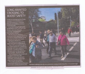
Newspaper Clipping, Diamond Valley Leader, Long awaited crossing to boost safety, 27/09/2017
... pedestrian crossing...Years of campaigning have finally resulted in the installation of a signalled pedestrian crossing at Flintoff and Grimshaw Streets in Greensborough....Greensborough Historical Society 34A Glenauburn Road Lower Plenty Lower Plenty melbourne Years of campaigning have finally resulted in the installation of a signalled pedestrian crossing at Flintoff and Grimshaw Streets in Greensborough. pedestrian crossing flintoff street greensborough grimshaw street greensborough watermarc News article 1 page, black text, colour image. ...Years of campaigning have finally resulted in the installation of a signalled pedestrian crossing at Flintoff and Grimshaw Streets in Greensborough.News article 1 page, black text, colour image.pedestrian crossing, flintoff street greensborough, grimshaw street greensborough, watermarc -
![Newspaper Clipping, Diamond Valley Leader, Crossing angst builds [Mo4112], 15/11/2017](/media/collectors/4f729f5697f83e03086015b8/items/5a16366621ea700340c11290/item-media/5a29038021ea701eb44499d4/item-fit-380x285.jpg?cb=6) Greensborough Historical Society
Greensborough Historical SocietyNewspaper Clipping, Diamond Valley Leader, Crossing angst builds [Mo4112], 15/11/2017
... ...pedestrian crossing...Anxious parents are concerned about the delay in fixing a dangerous pedestrian crossing outside Montmorency Primary School...Greensborough Historical Society 34A Glenauburn Road Lower Plenty Lower Plenty melbourne Anxious parents are concerned about the delay in fixing a dangerous pedestrian crossing outside Montmorency Primary School montmorency primary school pedestrian crossing banyule city council school crossings News article 1 page, black text and colour image . ...Anxious parents are concerned about the delay in fixing a dangerous pedestrian crossing outside Montmorency Primary SchoolNews article 1 page, black text and colour image .montmorency primary school, pedestrian crossing, banyule city council, school crossings -
 Ringwood and District Historical Society
Photograph, Taken from Eastland access road looking south-west, on 21 April 2009. Showing library and pedestrian walk and crossing
... Showing library and pedestrian walk and crossing....Showing library and pedestrian walk and crossing. Photograph ...Ron Brons photographic study of Ringwood. -
 Vision Australia
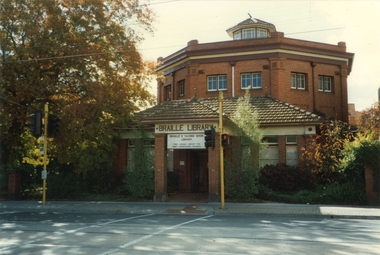
Photograph - Image, Braille and Talking Book Library building
... Red octagonal brick building facing pedestrian crossing and roadway...Braille & Talking Book Library Robert de Graauw Red octagonal brick building facing pedestrian crossing and roadway Braille and Talking Book Library building Photograph Image Robert Degraauw ...With its distinct octagonal shape, the Braille and Talking Book Library was a distinctive building in Commercial Road. This view, taken in the mid-1990's by employee Robert Degraauw, shows the Commercial Road frontage, as well as the pedestrian lights across and the tram tracks in the roadway.Red octagonal brick building facing pedestrian crossing and roadwaybraille & talking book library, robert de graauw -
 Canterbury History Group
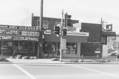
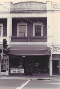
Photograph - 227 Canterbury Road shop, Jan Pigot, July 1993
... ...Pedestrian Crossing...227 Canterbury Road shop Canterbury Road shops Pedestrian Crossing black and white photograph Photograph 227 Canterbury Road shop Jan Pigot ...227 Canterbury Road shopblack and white photographcanterbury road shops, pedestrian crossing -
 Ballarat Heritage Services
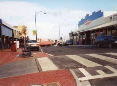
Digital photograph, Lisa Gervasoni, Portland, c2015
... ...pedestrian crossing...Ballarat Heritage Services PO Box 2209 Bakery Hill Post Office goldfields portland heritage building bluestone pedestrian crossing Portland Digital photograph Lisa Gervasoni ...portland, heritage, building, bluestone, pedestrian crossing -
 Bendigo Historical Society Inc.
Slide - BENDIGO BUILDINGS & SCENERY, Oct 1070
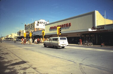
... Bendigo Buildings & Scenery. The pedestrian crossing in Queen Street, Bendigo,...Bendigo Buildings & Scenery. The pedestrian crossing in Queen Street, Bendigo, Slide BENDIGO BUILDINGS & SCENERY. ...Slide. Bendigo Buildings & Scenery. The pedestrian crossing in Queen Street, Bendigo,slide, bendigo, bendigo buildings & scenery., bendigo buildings & scenery. -
 Stawell Historical Society Inc
Photograph, Gold Reef Mall -- Main Street Stawell 2003
... Colour Photograph: Looking West showing a Pedestrian crossing near Victoria Place....Stawell Historical Society Inc 46 Longfield St Stawell grampians Gold Reef Mall Main Street 2003 stawell business Colour Photograph: Looking West showing a Pedestrian crossing near Victoria Place. Gold Reef Mall -- Main Street Stawell 2003 Photograph ...Gold Reef Mall Main Street 2003Colour Photograph: Looking West showing a Pedestrian crossing near Victoria Place.stawell business -
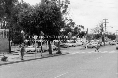
 Eltham District Historical Society Inc
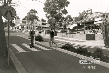
Photograph, Arthur Street, Eltham near corner with Main Road, Aug 1992, 4/8/92
... Four black and white photographs showing pedestrian crossing Arthur Street, Eltham, 1992....Eltham District Historical Society Inc 728 Main Rd Eltham melbourne arthur street eltham shops traffic Four black and white photographs showing pedestrian crossing Arthur Street, Eltham, 1992. Arthur Street, Eltham near corner with Main Road, Aug 1992 Photograph ...Four black and white photographs showing pedestrian crossing Arthur Street, Eltham, 1992.arthur street, eltham, shops, traffic -
 Ringwood and District Historical Society
Newspaper, Scrapbook Clipping, Library Collection, Ringwood, Victoria, `
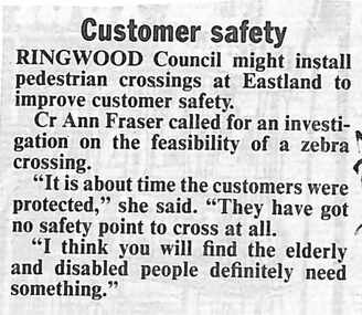
... Ringwood Council might install pedestrian crossings at Eastland to improve customer safety. ...Ringwood and District Historical Society 125A Warrandyte Road Ringwood North melbourne ` ` ` Ringwood Council might install pedestrian crossings at Eastland to improve customer safety. ...``Newspaper clipping from The Mail, 13-07-93 Customer safetyRingwood Council might install pedestrian crossings at Eastland to improve customer safety. Cr Ann Fraser called for an investigation on the feasibility of a zebra crossing.` -
 Eltham District Historical Society Inc
Photograph, Looking north along the west side of Main Road through the shopping centre, Eltham, February 1968, Feb 1968
... Shows the pedestrian crossing to the Railway Station and car parking....Shows the pedestrian crossing to the Railway Station and car parking. ...Shows the pedestrian crossing to the Railway Station and car parking.In February 1968 an unknown person took a series of photos from the Eltham Hotel at Pitt Street heading north along Main Road through the shopping centre to just north of Elsa Court covering the length of the section of Main Road which was duplicated shortly thereafter. Shows the condition and environment of the streesscape of Main Road, Eltham immediately prior to the duplication between Pitt Street and Elsa Court through the shopping centre. Also shows a number of shops and businesses that operated at that time.Black and white photographduplication, eltham, main road, carparks, railway station, post office, shopping centre -
 Sunbury Family History and Heritage Society Inc.
Photograph, Rosa McCall, Ligar Street, February 2014
... A non-digital coloured photograph of a street with a fenced in area adjacent to a weatherboard cottage. A pedestrian crossing is in the foreground and a small white car is parked further down the street. ...Ligar Street Sunbury Californian Cottages A non-digital coloured photograph of a street with a fenced in area adjacent to a weatherboard cottage. A pedestrian crossing is in the foreground and a small white car is parked further down the street. ...This is a view of Ligar Street looking towards Riddell Road and opposite the tennis courts, taken in February 2014. The weatherboard Californian cottage was probably built in the 1920s and is one of a few other cottages of this style in Sunbury.A non-digital coloured photograph of a street with a fenced in area adjacent to a weatherboard cottage. A pedestrian crossing is in the foreground and a small white car is parked further down the street. There are trees visible in the distance.ligar street, sunbury, californian cottages -
 Musculoskeletal Health Australia (now held by the Glen Eira Historical Society)
Photograph - Object, March - April 1994
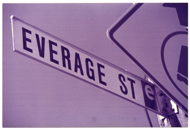
... Another road sign, for a pedestrian crossing (partially obscured) is also in the frame. ...Another road sign, for a pedestrian crossing (partially obscured) is also in the frame. ...In around March to April 1994, the Arthritis Foundation of Victoria (AFV) opened a second oppportunity shop in Moonee Ponds. This photo depicts a close up photo of the street sign for "Everage Street", taken from a low angle. The street, which runs beside a carpark behind the main shopping strip on Puckle St, was named after internationally renowed Australian satirist Barry Humphries' character, Dame Edna Everage. The character's surname is a play on words: before she became a dame, Edna was an 'average' housewife who famously hailed from the Melbourne suburb of Moonee Ponds. https://www.victorianplaces.com.au/moonee-pondsB&W photo of a street sign name "Everage St". Another road sign, for a pedestrian crossing (partially obscured) is also in the frame. The photo has been taken from a low angle.arthritis foundation of victoria, afv, opportunity shop, op shop, charity shop, everage street, moonee ponds, 1994 -
 Eltham District Historical Society Inc
Photograph, Looking northwest acroos Main Road from near Arthur Street, Eltham, February 1968, Feb 1968
... Shows the car parking on the west side of Main Road, part of the Post Office on left and the pedestrian crossing from the railway station....Shows the car parking on the west side of Main Road, part of the Post Office on left and the pedestrian crossing from the railway station. In February 1968 an unknown person took a series of photos from the Eltham Hotel at Pitt Street heading north along Main Road through the shopping centre to just north of Elsa Court covering the length of the section of Main Road which was duplicated shortly thereafter. ...Shows the car parking on the west side of Main Road, part of the Post Office on left and the pedestrian crossing from the railway station.In February 1968 an unknown person took a series of photos from the Eltham Hotel at Pitt Street heading north along Main Road through the shopping centre to just north of Elsa Court covering the length of the section of Main Road which was duplicated shortly thereafter. Shows the condition and environment of the streesscape of Main Road, Eltham immediately prior to the duplication between Pitt Street and Elsa Court through the shopping centre. Also shows a number of shops and businesses that operated at that time.Black and white photographduplication, eltham, main road, carparks, railway station, post office -
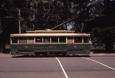 Ballarat Tramway Museum
Slide - 35mm slide/s, Chas Bevan, 19/12/1970 12:00:00 AM
... Colour slide - 35mm - of Ballarat single trucker No. 32, northbound in Wendouree Parade, about to enter Gardens loop, passing over the pedestrian crossing. Side on view. Photo taken by Chas Bevan on Saturday 19-12-1970....Colour slide - 35mm - of Ballarat single trucker No. 32, northbound in Wendouree Parade, about to enter Gardens loop, passing over the pedestrian crossing. Side on view. Photo taken by Chas Bevan on Saturday 19-12-1970. ...Yields information about tram No. 32, side on view at the Gardens.Colour slide - 35mm - of Ballarat single trucker No. 32, northbound in Wendouree Parade, about to enter Gardens loop, passing over the pedestrian crossing. Side on view. Photo taken by Chas Bevan on Saturday 19-12-1970."Ballarat trams 19-12-70" in ink.tramways, trams, wendouree parade, gardens loop, tram 32 -
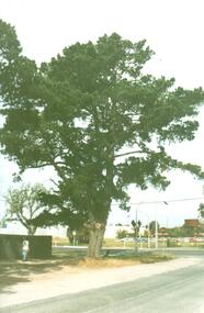 Hume City Civic Collection
Photograph, Early 1990's
... A large pine tree is growing at the corner immediately in front of a pedestrian crossing. The railway car park, metal water tower and Coles Supermarket are in the background. ...A large pine tree is growing at the corner immediately in front of a pedestrian crossing. The railway car park, metal water tower and Coles Supermarket are in the background. ...The photograph was taken after Coles Supermarket and Sunbury Shopping Square were constructed on the railway land on the east side of the line in 1989, but before the Safeway-Woolworths complex was built in 2000 on the west side of the railway line. The open land on the west side of the line was used by rail communters as a car park.A coloured photograph showing part of the T intersection at Cornish and Horne Streets. A large pine tree is growing at the corner immediately in front of a pedestrian crossing. The railway car park, metal water tower and Coles Supermarket are in the background. A boy is walking along the footpath.cornish street, horne street, water towers, coles supermarket, sunbury railway station, george evans collection -
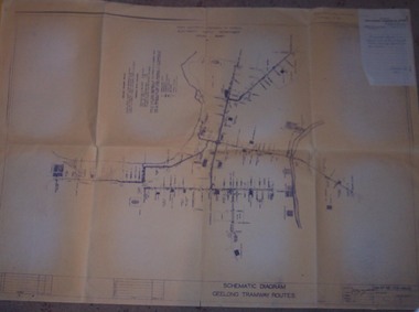 Ballarat Tramway Museum
Drawing - Map, State Electricity Commission of Victoria (SECV), "Schematic Diagram Geelong Tramway Routes", 1953
... The drawing is very detailed showing streets, cross streets, route, loops, schools, woollen mills, ovals, sections, track phones, stops, route and track miles, pedestrian crossings, railway stations and notes on through route mileages....The drawing is very detailed showing streets, cross streets, route, loops, schools, woollen mills, ovals, sections, track phones, stops, route and track miles, pedestrian crossings, railway stations and notes on through route mileages. ...The drawing is very detailed showing streets, cross streets, route, loops, schools, woollen mills, ovals, sections, track phones, stops, route and track miles, pedestrian crossings, railway stations and notes on through route mileages.Print of a drawing showing in very good detail, the schematic layout of the Geelong Tram system. Produced in 1953 and sent to Tramway Supt. in 1970 for his records. Gives very detailed information on another SEC tramway system.Dyeline print of SEC Drawing No. GE-T13-8829, titled "Schematic Diagram Geelong Tramway Routes". Drawing prepared 27/8/1953. Stapled to the top right hand corner of the sheet is a SEC memo form from finance section, distribution services to the Dept. Tramway Superintendent, Ballarat, dated 6-2-1970 forwarding Les Denmead the plan. Was unstapled during the 1/2008 copying of the drawing. Item 10920 is a copy of the same drawing donated by VicTrack via the Melbourne Tramway Museum. On top right hand corner of drawing, "Ballarat Tramway Preservation Society Catalogue No. 605" in ink and on rear in two places "Geelong Tramways" and one "BTPS 605"geelong, map, track layout, tram stops