Showing 94 items matching "picnic table"
-
 Ballarat Heritage Services
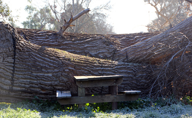
Digital Photograph, L.J. Gervasoni, Crushed picnic table at Warrnambool, c2015
... Crushed picnic table at Warrnambool......picnic table...Colour photograph of a crushed picnic table, which occured when a limb fell from a tree at Warrnambool....Ballarat Heritage Services PO Box 2209 Bakery Hill Post Office goldfields guildford picnic oak damage picnic table Colour photograph of a crushed picnic table, which occured when a limb fell from a tree at Warrnambool. ...Colour photograph of a crushed picnic table, which occured when a limb fell from a tree at Warrnambool.guildford, picnic, oak, damage, picnic table -
 Port Melbourne Historical & Preservation Society
Photograph - Group at picnic table, Sandridge Beach, 1992
... Group at picnic table, Sandridge Beach...Photograph of group at picnic table, Sandridge Beach c 1992, posed for children's week poster. ...Evelyn "May" Kennedy with four children: 3 Edwards' and Sean Photograph Group at picnic table, Sandridge Beach ...This photo was used on a Chidren's Week poster. Local identity May Kennedy was noted for fostering children in Port for 43 yearsPhotograph of group at picnic table, Sandridge Beach c 1992, posed for children's week poster. Evelyn "May" Kennedy with four children: 3 Edwards' and SeanPort Pics 20128130140.jes}002.01 4811221 NNNN --- MoF R000.12066-S/100.5children, evelyn 'may' kennedy, bridie edwards, stewart edwards, jessica edwards, sean -
 Eltham District Historical Society Inc
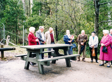
Photograph, Dedication of picnic table at Wilks Creek Bridge, Marysville by Marysville Historical Society, 13 October 1993, 13/10/1993
... Dedication of picnic table at Wilks Creek Bridge, Marysville by Marysville Historical Society, 13 October 1993...Activities Marysville Wilks Creek Bridge Two colour photographs Dedication of picnic table at Wilks Creek Bridge, Marysville by Marysville Historical Society, 13 October 1993 Photograph ...Wilks Creek Bridge was built in 1870. It was last used for heavy vehicle traffic in 1980 and left to decay until it was demolished in 2008. The last remnants of the timber structure were destroyed in the Black Saturday bushfire of 7 February 2009. [from EDHS Newsletter No. 93, November 1993:] OTHER NEWS A small group of members represented the Society at the opening of the picnic ground at the historic Wilks Creek Bridge at Marysville. The event included the launching of a booklet by our friend Ann Thomas on the history of the bridge which was located on the old Yarra Track coaching route between Eltham and Woods Point. Ann has donated a copy of the booklet to our Society.Two colour photographsactivities, marysville, wilks creek bridge -
 Department of Health and Human Services
Photograph, Picnic table with Rosella - Occupational Therapy Program 1981 / Country Music Festival & Christmas Party 1982 - CALOOLA TRAINING CENTRE - SUNBURY - SERIES 251
... Picnic table with Rosella - Occupational Therapy Program 1981 / Country Music Festival & Christmas Party 1982 - CALOOLA TRAINING CENTRE - SUNBURY - SERIES 251...Department of Health and Human Services 50 Lonsdale St Melbourne melbourne Picnic table with Rosella - Occupational Therapy Program 1981 / Country Music Festival & Christmas Party 1982 - CALOOLA TRAINING CENTRE - SUNBURY - SERIES 251 Photograph Photograph ... -
 Rutherglen Historical Society
Image, Robert B Billings, c1953
... Photograph of the Billings children at a picnic table at the side of Lake King....Several children are seated at a picnic table....Several children are seated at a picnic table. Image Robert B Billings ...Photograph of the Billings children at a picnic table at the side of Lake King.Black and white photograph of park with trees reflected on the surface of a lake. Several children are seated at a picnic table.Written on back of photo: "Rutherglen Lake. About 1953. (Stopped at [Browning?] Road)billings family, lake king, rutherglen park -
 Lakes Entrance Historical Society
Photograph - Cunninghame Arm footbridge, LE Tidy Town Committee, Lakes Entrance Victoria, 1994 c
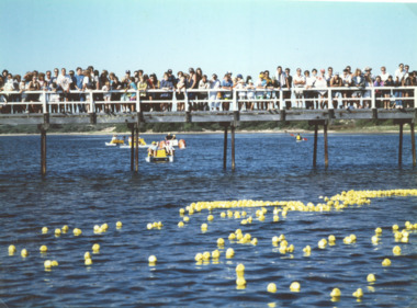
... Also a colour photograph of four people at picnic table adjacent to Northern end of Cunninghame Arm Footbridge Lakes Entrance 05158.1. 10 x 15 cm...Also a colour photograph of four people at picnic table adjacent to Northern end of Cunninghame Arm Footbridge Lakes Entrance...Also a colour photograph of four people at picnic table adjacent to Northern end of Cunninghame Arm Footbridge Lakes Entrance Lakes Entrance Victoria Photograph Cunninghame Arm footbridge LE Tidy Town Committee ...Also a colour photograph of four people at picnic table adjacent to Northern end of Cunninghame Arm Footbridge Lakes Entrance 05158.1. 10 x 15 cmColour photograph showing crowd of people on Cunninghame Arm footbridge at start of the Duck Race a local fundraiser with paddle boats in background Lakes Entrance Victoria. Also a colour photograph of four people at picnic table adjacent to Northern end of Cunninghame Arm Footbridge Lakes Entrancewaterfront, bridges -
 Lakes Entrance Historical Society
Photograph - Lions Park Eastern Beach Lakes Entrance Victoria 2000, Lakes Entrance Tidy Town Committee
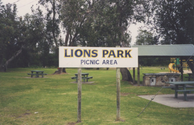
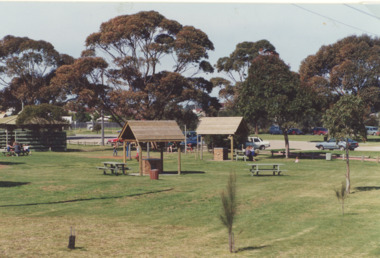
... Colour photograph of Lions Park Eastern Beach showing barbeques under shelter and picnic tables Lakes Entrance Victoria...Recreation Parks Lions Club Colour photograph of Lions Park Eastern Beach showing barbeques under shelter and picnic tables Lakes Entrance Victoria Photograph Lions Park Eastern Beach Lakes Entrance Victoria 2000 Lakes Entrance Tidy Town Committee ...Colour photograph of Lions Park Eastern Beach showing barbeques under shelter and picnic tables Lakes Entrance Victoriarecreation, parks, lions club -
 Bendigo Historical Society Inc.
Photograph - PETER ELLIS COLLECTION: PICNIC
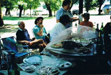
... Colour photograph. Picnic table set with food. People in camp chairs. ...History House 11 Mackenzie Street Bendigo goldfields PHOTO Group mixed group Colour photograph. Picnic table set with food. People in camp chairs. ...Colour photograph. Picnic table set with food. People in camp chairs. Caravan. Back of photo has sticky tape stuck to it.photo, group, mixed group -
 Bendigo Historical Society Inc.
Photograph - PETER ELLIS COLLECTION: PETER SUTTON
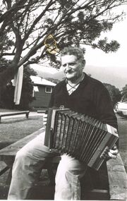
... Black and white photo of Peter Sutton sitting on the end of a wooden picnic table playing an accordion. Written on the back: Peter Sutton. ...History House 11 Mackenzie Street Bendigo goldfields PHOTO Individual peter sutton Peter Ellis Collection Peter Sutton Black and white photo of Peter Sutton sitting on the end of a wooden picnic table playing an accordion. Written on the back: Peter Sutton. ...Black and white photo of Peter Sutton sitting on the end of a wooden picnic table playing an accordion. Written on the back: Peter Sutton. Last lighthouse keeper at Wilson's Promontory (?)photo, individual, peter sutton, peter ellis collection, peter sutton -
 Lakes Entrance Historical Society
Photograph - Apex Park , Lakes Entrance Victoria, L E Tidy Town Committee, 1994
... Colour photograph of Apex Park barbeque area with people seated at picnic tables, cars parked at Visitors Information Centre glimpsed through trees, Lakes Entrance Victoria...Lakes Entrance Historical Society 4 Marine Parade Lakes Entrance gippsland Also two colour photographs of barbeques and seating at Apex Park numbers 04240.1 and 04240.2 size 10 x 15 cm Parks Gippsland Lakes Recreation Facilities Colour photograph of Apex Park barbeque area with people seated at picnic tables, cars parked at Visitors Information Centre glimpsed through trees, Lakes Entrance Victoria Apex Park , Lakes Entrance Victoria Photograph Apex Park , Lakes Entrance Victoria L E Tidy Town Committee ...Also two colour photographs of barbeques and seating at Apex Park numbers 04240.1 and 04240.2 size 10 x 15 cmColour photograph of Apex Park barbeque area with people seated at picnic tables, cars parked at Visitors Information Centre glimpsed through trees, Lakes Entrance Victoriaparks, gippsland lakes, recreation facilities -
 Sunbury Family History and Heritage Society Inc.
Photograph, Bulla Primary School, Hanging Rock, 1995
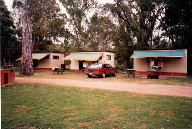
... A red car is parked outside one of the cabins as well as two permanent picnic tables....A red car is parked outside one of the cabins as well as two permanent picnic tables. Hanging Rock Photograph Bulla Primary School ...In 1995, the upper school students from Bulla Primary School attended a camp at Hanging Rock Reserve which is part of the Macedon Ranges. At this camp the students were shown basic rock climbing skills and explored the rock for its interesting geological formations. Hanging Rock, also known as Mount Diogenes, is the traditional land of the Dja Dja Wurrung, Woi Wurrung and Taungurung people. It is a mamelon formed when magma poured from a vent and congealed. There are interesting rock functions at the site such as the Colonnade, the Eagle and the UFO. The highest point on the rock is 718metres above sea level and 105 meters above the land at its base.Hanging Rock is an important geological and volcanic structure in the Macedon Ranges area and in central Victoria. A non-digital coloured photograph of three holiday cabins and a barbecue in a bushland setting. A red car is parked outside one of the cabins as well as two permanent picnic tables.hanging rock, mount diogenes, mamelons, volcanoes, school camps, bulla primary school -
 Lakes Entrance Historical Society
Photograph - Johnsonville School new classroom 1985
... Black and white photograph of four named people standing around picnic table following the opening ceremony for the newly installed portable schoolroom at primary school. ...Schools Celebrations Black and white photograph of four named people standing around picnic table following the opening ceremony for the newly installed portable schoolroom at primary school. ...Persons identified as Peter Bragg (centre) Dominique and Laurel Spiller - fourth person unknown.Black and white photograph of four named people standing around picnic table following the opening ceremony for the newly installed portable schoolroom at primary school. Johnsonville Victoriaschools, celebrations -
 Ithacan Historical Society
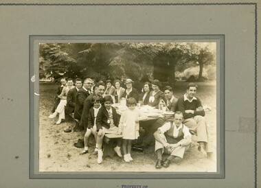
Photograph, Ithacan Picnic Family Group, c 1930s
... A black and white photograph of eight men, seven ladies and three children sitting around a picnic table laid out for a meal in a large outdoor area. ...A black and white photograph of eight men, seven ladies and three children sitting around a picnic table laid out for a meal in a large outdoor area. ...The annual picnic organised by the Ithacan Philanthropic Society has been a popular event on the club's calendar every year since its inception in 1916. It was a chance for families and friends to meet together in a relaxed atmosphere where races were also organised for all age groups. The picnics were held at recreation grounds on Melbourne's rural fringe and for many years Bacchus Marsh was a popular venue.A black and white photograph of eight men, seven ladies and three children sitting around a picnic table laid out for a meal in a large outdoor area. There are large trees in the background. -
 Lakes Entrance Historical Society
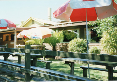
Photograph - Kiosk on the hummocks. Lakes Entrance Victoria c1990, Fish Marie, 1990c
... It shows the kiosk with enlarged dining room, garden with rustic picnic tables and seats and three open colored sun umbrellas. ...It shows the kiosk with enlarged dining room, garden with rustic picnic tables and seats and three open colored sun umbrellas. ...Colour photograph of the kiosk on the hummocks. It shows the kiosk with enlarged dining room, garden with rustic picnic tables and seats and three open colored sun umbrellas. Lakes Entrance Victoria waterfront, restaurant, business, beach -
 Lakes Entrance Historical Society
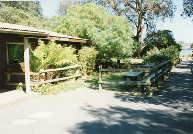
Photograph - Footbridge Kiosk Lakes Entrance Victoria c1990, Fish, Marie, the kiosk Lakes Entrance Victoria
... It shows a corner of the kiosk, the rustic garden, picnic tables and seats. Pathway to footbridge and glimpse of Cunninghame Arm in distance. ...It shows a corner of the kiosk, the rustic garden, picnic tables and seats. Pathway to footbridge and glimpse of Cunninghame Arm in distance. ...Colour photograph of the kiosk on the sand hummocks. It shows a corner of the kiosk, the rustic garden, picnic tables and seats. Pathway to footbridge and glimpse of Cunninghame Arm in distance. Lakes Entrance Victoria recreation, retail, business, beach -
 Lakes Entrance Historical Society
Photograph - Esplanade Lakes Entrance 1999
... It shows vessels moored at jetty path beside Lakes, seats and picnic tables and newly planted trees on lawn verge of highway. ...It shows vessels moored at jetty path beside Lakes, seats and picnic tables and newly planted trees on lawn verge of highway. ...Date made 10 April 1999Color photograph of Esplanade and waterfront. It shows vessels moored at jetty path beside Lakes, seats and picnic tables and newly planted trees on lawn verge of highway. Lakes Entrance VictoriaThe Esplanade Lakes Entrance 10/4/99 (on back)jetties, waterfront, boats and boating -
 Lakes Entrance Historical Society
Photograph - Johnsonville School new classroom 1985
... Black and white photograph of group of people standing around the picnic table and barbecue following the cutting of the ribbons to open the newly installed portable school room at primary school. ...Schools Celebrations Black and white photograph of group of people standing around the picnic table and barbecue following the cutting of the ribbons to open the newly installed portable school room at primary school. ...Black and white photograph of group of people standing around the picnic table and barbecue following the cutting of the ribbons to open the newly installed portable school room at primary school. Johnsonville Victoriaschools, celebrations -
 Greensborough Historical Society
Slide - Photograph, John Ramsdale, Car park on Kurrak Road Yarrambat: Slide 45, 1990s
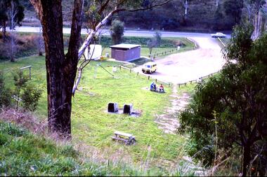
... Photograph shows a park and carparking area with people sitting at picnic table, Middle Gorge Park, Yarrambat....Greensborough Historical Society 34A Glenauburn Road Lower Plenty Lower Plenty melbourne Photograph shows a park and carparking area with people sitting at picnic table, Middle Gorge Park, Yarrambat. Part of the John Ramsdale collection of slides and audio visual material. middle gorge park yarrambat kurrak road yarrambat No maker's marks. ...Photograph shows a park and carparking area with people sitting at picnic table, Middle Gorge Park, Yarrambat.Part of the John Ramsdale collection of slides and audio visual material.Colour photograph scanned from slide.No maker's marks. No caption on slide.middle gorge park, yarrambat, kurrak road yarrambat -
 Musculoskeletal Health Australia (now held by the Glen Eira Historical Society)
Photograph - Group photo, 11/04/2000
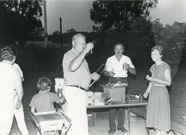
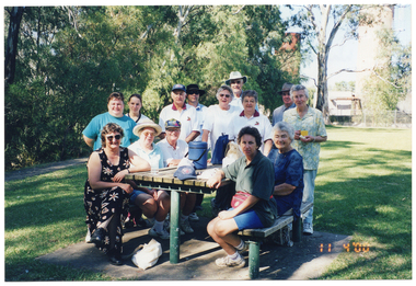
... COL photo of a group of people gathered around a wooden picnic table in a park. Most of the people are standing around the picnic table, while some people are sitting on the two benches on either side. ...COL photo of a group of people gathered around a wooden picnic table in a park. Most of the people are standing around the picnic table, while some people are sitting on the two benches on either side. ...This photo depicts participants of the Joint Walk organised by the Rochester Arthritis Support Group for National Arthritis Week (NAW).COL photo of a group of people gathered around a wooden picnic table in a park. Most of the people are standing around the picnic table, while some people are sitting on the two benches on either side. There are a few items on the table, such as a water bottle, some backpacks, a cap, and a small drink cooler box (known in Australian vernacular as an 'esky', or a 'chilly bin' in New Zealand vernacular). In the background, there are some large trees, and a large tank beyond a cyclone fence.[Handwritten in blue ink] 16 [circled] Walkers for Arthritis Week on 11th April, 2000 Campaspe River, Rochester.arthritis victoria, av, national arthritis week, naw, rochester arthritis support group, joint walk, campapse river, 2000 -
 Lakes Entrance Historical Society
Photograph - Broomes Maranui , Police Station Esplanade Lakes Entrance Victoria c1938
... In foreground is the stone wall beside the lake, concrete path and picnic table beside the Esplanade Lakes Entrance Victoria. c1938 ...In foreground is the stone wall beside the lake, concrete path and picnic table beside the Esplanade Lakes Entrance Victoria. c1938 Accommodation Transport Black and white photograph of a postcard showing Broomes Maranui Guesthouse with Police Station on the western side and the picture theatre on the eastern side. ...In foreground is the stone wall beside the lake, concrete path and picnic table beside the Esplanade Lakes Entrance Victoria. c1938 Black and white photograph of a postcard showing Broomes Maranui Guesthouse with Police Station on the western side and the picture theatre on the eastern side.accommodation, transport -
 Lakes Entrance Historical Society
Photograph - Rotary, Lakes Post Newspaper, 1992
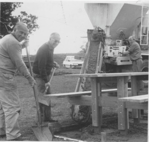
... Black and white photograph Rotary club members Tom Allen ,Stewart Marsh ,Eric Robinson concrete truck laying concrete base for picnic table at Jemmys Point park. Lakes Entrance Victoria...Lakes Entrance Historical Society 4 Marine Parade Lakes Entrance gippsland Rotary Club Volunteering Black and white photograph Rotary club members Tom Allen ,Stewart Marsh ,Eric Robinson concrete truck laying concrete base for picnic table at Jemmys Point park. Lakes Entrance Victoria Photograph Rotary Lakes Post Newspaper ...Black and white photograph Rotary club members Tom Allen ,Stewart Marsh ,Eric Robinson concrete truck laying concrete base for picnic table at Jemmys Point park. Lakes Entrance Victoriarotary club, volunteering -
 Whitehorse Historical Society Inc.
Article, Scott Grove Reserve, Aug 2023
... The reserve includes 50 trees, local indigenous plants, a picnic table and seating, fitness equipment, a playground and a nature play area....Whitehorse Historical Society Inc. 2-10 Deep Creek Road Mitcham melbourne The reserve includes 50 trees, local indigenous plants, a picnic table and seating, fitness equipment, a playground and a nature play area. ...A new open space park has been established at 14 - 16 Scott Grove, Burwoodnon-fictionA new open space park has been established at 14 - 16 Scott Grove, Burwoodscott grove reserve, scott grove burwood no 14 -16, playgrounds -
 Ithacan Historical Society
Photograph, Picnic group, c1940s
... A sepia photograph mounted on board of five people and a baby sitting around a picnic table with five people standing at the back. ...A sepia photograph mounted on board of five people and a baby sitting around a picnic table with five people standing at the back. ...The group were at an Ithacan picnic at Bacchus Marsh sometime in the 1940s. The man at the back is wearing on his lapel the medallion badge which was given to all attendees on arrival at the picnic. A sepia photograph mounted on board of five people and a baby sitting around a picnic table with five people standing at the back. A man dressed in light clothes is standing on the left taking a photograph of then group. There are trees in then background. -
 Lakes Entrance Historical Society
Photograph - Johnsonville School students at Log Crossing, 1984
... Black and white photograph of children from Johnsonville Primary School sitting at picnic table, eating lunch adults also in group, cars parked among tall trees in background, Log Crossing, Kalimna Victoria...Schools activities Black and white photograph of children from Johnsonville Primary School sitting at picnic table, eating lunch adults also in group, cars parked among tall trees in background, Log Crossing, Kalimna Victoria Photograph Johnsonville School students at Log Crossing, 1984 ...Black and white photograph of children from Johnsonville Primary School sitting at picnic table, eating lunch adults also in group, cars parked among tall trees in background, Log Crossing, Kalimna Victoriaschools, activities -
 Lakes Entrance Historical Society
Photograph - Footbridge Kiosk Lakes Entrance Victoria c1980, Tambo Shire, kiosk on the hummocks. Lakes Entrance Victoria, 1980c
... It shows the recently renovated and extended kiosk and garden, nestling beside the scrub covered sand hummock. Rustic picnic tables and seats inside garden grounds. ...It shows the recently renovated and extended kiosk and garden, nestling beside the scrub covered sand hummock. Rustic picnic tables and seats inside garden grounds. ...This is the before paired photograph used in the 150 year Lakes Entrance 1858-2008 display.|The after paired photograph number is 01544.1|Also one 12 x 16 framed photograph used in room display.Colour photograph of the kiosk on the hummocks. It shows the recently renovated and extended kiosk and garden, nestling beside the scrub covered sand hummock. Rustic picnic tables and seats inside garden grounds. Lakes Entrance Victoriawaterfront, restaurant -
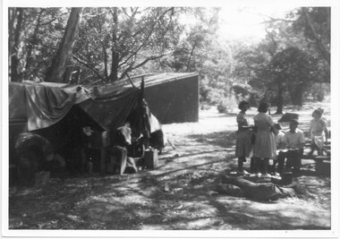 Halls Gap & Grampians Historical Society
Photograph - B/W, C 1940s
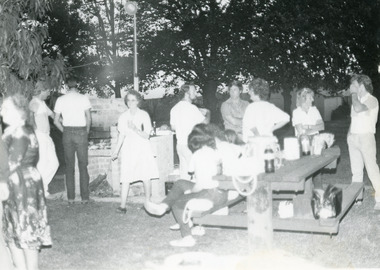
... The photo shows a group of six people, two standing near, and four seated at, a picnic table. There is a large canvas tent/structure with boxes and tins at the entrance to the left and behind it there is a corrugated iron building. ...RECREATION Camping SCENERY Zumsteins The photo shows a group of six people, two standing near, and four seated at, a picnic table. There is a large canvas tent/structure with boxes and tins at the entrance to the left and behind it there is a corrugated iron building. ...This is a photo of the Zumsteins camping area, which was popular with families.The photo shows a group of six people, two standing near, and four seated at, a picnic table. There is a large canvas tent/structure with boxes and tins at the entrance to the left and behind it there is a corrugated iron building. The area is surrounded by bush.recreation, camping, scenery, zumsteins -
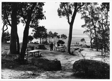 Halls Gap & Grampians Historical Society
Photograph, C 1960s (?)
... Photo shows two men standing close to a picnic table in a picnic area near a lookout (Boroka Lookout). ...Halls Gap & Grampians Historical Society Centennial Hall 117-119 Grampians Road Halls Gap grampians People at the Boroka Lookout picnic area. scenery lookouts Photo shows two men standing close to a picnic table in a picnic area near a lookout (Boroka Lookout). ...People at the Boroka Lookout picnic area.Photo shows two men standing close to a picnic table in a picnic area near a lookout (Boroka Lookout). Two other people are standing at the wire fence of the lookout. A valley and distant ranges can be seen in the background.scenery, lookouts -
 Musculoskeletal Health Australia (now held by the Glen Eira Historical Society)
Photograph - Solo photo, Herald and Weekly Times Ltd, 1985
... In the background, there is a small building, some large trees, and picnic tables and benches....In the background, there is a small building, some large trees, and picnic tables and benches. Photograph Solo photo Herald and Weekly Times Ltd ...Rikki Bewley is an occupational therapist who has ankylosing spondylitis. Rikki donated this photo of herself running to the Foundation, with an accompanying letter. The photo appears in the February 1985 issue of RAAV's quarterly newsletter, News Review, with the caption, "Photo courtesty Sun Herald" [sic]. The photo accompanies an article titled, "The last long race". The article is Rikki's own account of the last long race that she will run - the Big M Marathon in October. This photo also appears in the September 1985 issue of News Review.B&W photo of a woman running on the grass in a park. She is wearing a t-shirt with the words "I FIGHT ARTHRITIS" in capital letters on the front, and shorts. In the background, there is a small building, some large trees, and picnic tables and benches.[Handwritten in purple ink, in the top left corner] Rikki Bewley 1988 [On a blue sticky note, handwritten in blue ink] Rikki Bewley - check 1976 - 83 RAAVarthritis foundation of victoria, afv, rikki bewley, occupational therapist, ot, ankylosing spondylitis, marathon runner, big m marathon, article, the last long race, news review, 1985 -
 Lakes Entrance Historical Society
Photograph - Cunninghame Arm Lakes Entrance Victoria c1992, Lakes Post Newspaper
... It shows the scrub covered south shore, the Cunninghame Arm, the foreshore littered with dead seagrass, the path and lawn verge, and small concrete picnic table and broken seat. Lakes Entrance Victoria...It shows the scrub covered south shore, the Cunninghame Arm, the foreshore littered with dead seagrass, the path and lawn verge, and small concrete picnic table and broken seat. Lakes Entrance Victoria Photograph Cunninghame Arm Lakes Entrance Victoria c1992 Lakes Post Newspaper ...Black and white photograph of part of the lake and waterfront. It shows the scrub covered south shore, the Cunninghame Arm, the foreshore littered with dead seagrass, the path and lawn verge, and small concrete picnic table and broken seat. Lakes Entrance Victoria waterways, topography -
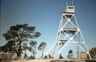 Bendigo Historical Society Inc.
Slide - PETER ELLIS COLLECTION: SLIDE, May 1970 - Jan 1972
... A tree with a picnic table and chairs at the bottom is on the right hand side....A tree with a picnic table and chairs at the bottom is on the right hand side. ...Coloured slide transparency. Image is of a tall metal tower on top of a hill. The tower is white and a ladder is visible on the right hand side. There are two aerials and a wooden building on the top platform. A tree with a picnic table and chairs at the bottom is on the right hand side.Kodachrome Transparencyslide, bendigo, bendigo institute of technology