Showing 88 items matching "pine creek"
-
 Eltham District Historical Society Inc
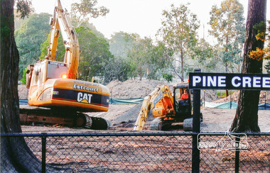
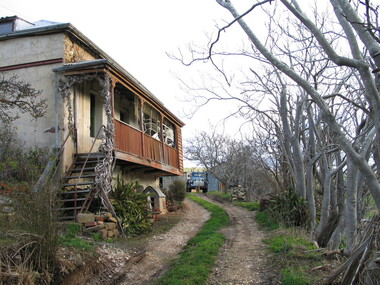
Photograph, Pine Creek, Diamond Valley Railway
... Pine Creek, Diamond Valley Railway...pine creek...Eltham District Historical Society Inc 728 Main Rd Eltham melbourne pine creek Colour photograph Pine Creek, Diamond Valley Railway Photograph ...Colour photographpine creek -
 Federation University Historical Collection
Booklet, Bulletin of the Northern Territory: Progress Report on the Gelogical Survey of the Pine Creek District, Northern Territory, 1914, 02/1914
... Bulletin of the Northern Territory: Progress Report on the Gelogical Survey of the Pine Creek District, Northern Territory, 1914......Pine Creek...Barker Library (top floor) Mount Helen goldfields northern territory mining mining act Pine Creek patrick mcMahon Glynn Bulletin of the Northern Territory: Progress Report on the Gelogical Survey of the Pine Creek District, Northern Territory, 1914 Booklet ...northern territory, mining, mining act, pine creek, patrick mcmahon glynn -
 Ballarat Heritage Services
Photograph - Colour, Clare Gervasoni, 'Pine View' Yandoit Creek, 2016, 16/01/2016
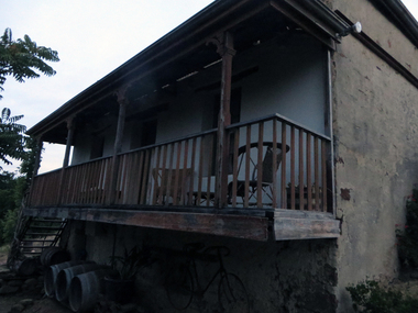
... 'Pine View' Yandoit Creek, 2016...Colour photographs of Pine View, Yandoit Creek....Colour photographs of Pine View, Yandoit Creek. 'Pine View' Yandoit Creek, 2016 Photograph - Colour Clare Gervasoni ...Pine View was the family home of Giovanni (John) Gervasoni and his family. It was passed to John's youngest son, Vincent Michael Gervasoni. Colour photographs of Pine View, Yandoit Creek. -
 Bendigo Military Museum
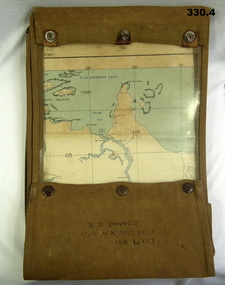
Map - MAP CASE & MAPS, Hec Robinson, C.1939-45
... ...Pine Creek...Scale 4 miles to 1 inch. .3) Map, folded, New Guinea made by Hec Robinson Sydney .4) Map Pine Creek N.T....Maps WWII World War Two Second World War Map Cases Darwin Northern Territory Pine Creek Papua New Guinea Navigation Pouches zippered section marked "J. ...John James Davies No VX35280 enlisted in the 2nd AIF on 1.8.40 age 31 years. At discharge on 30.11.45 he held the rank of WO 2nd class in 2/108th Aust Light Anti Aircraft detachment..1) Map case, canvas khaki. .2) Map of Darwin, NT. Scale 4 miles to 1 inch. .3) Map, folded, New Guinea made by Hec Robinson Sydney .4) Map Pine Creek N.T.zippered section marked "J. J. Davies VX35280 108 LAD”maps, wwii, world war two, second world war, map cases, darwin, northern territory, pine creek, papua new guinea, navigation, pouches -
Bass Coast Shire Council - Art Collection
Artwork, other - Cypress Pine, Archies Creek, Matthew Petrucci
... Cypress Pine, Archies Creek...Bass Coast Shire Council - Art Collection 76 McBride Ave Wonthaggi Australia Signed Oil on canvas Matthew Petrucci Artwork, other Cypress Pine, Archies Creek ...AustraliaOil on canvasSigned -
 Bendigo Historical Society Inc.
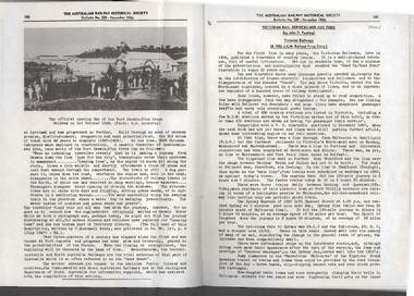
Book - RAILWAYS COLLECTION: THE AUSTRALIAN RAILWAY HISTORICAL SOCIETY NOVEMBER 1956, 1956
... opening day of the Port Darwin -Pine Creek Railway...There is a photo of opening day of the Port Darwin -Pine Creek Railway on 1.10.1889. An A Class train is shown. ...There is a photo of opening day of the Port Darwin -Pine Creek Railway on 1.10.1889. An A Class train is shown. ...Railways Collection - Article from Pages 160-161 of The Australian Railway Historical Society November 1956 Bulletin No. 229. There is a photo of opening day of the Port Darwin -Pine Creek Railway on 1.10.1889. An A Class train is shown. Page 161 has an article Victorian Rail Services now and then by John D. Keating.John D. Keatingrailways, bendigo to melbourne, opening day of the port darwin -pine creek railway -
 Ballarat Heritage Services
Photograph - Photograph - Colour, Pine View, Yandoit Creek, 2004, 26/06/2004
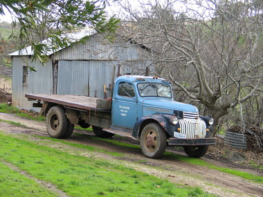
... Pine View, Yandoit Creek, 2004...creek...yandoit...pine...Colour photograph of Pine View, the home of Vince Gervasoni, of Yandoit Creek....Pine View, Yandoit Creek, 2004 Photograph Photograph - Colour Lisa Gervasoni ...Colour photograph of Pine View, the home of Vince Gervasoni, of Yandoit Creek.yandoit creek, yandoit, pine view, vince gervasoni, vince gervasoni's truck -
 Federation University Historical Collection
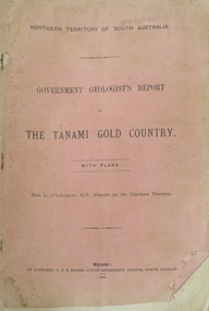
Booklet, Northern Territory ... The Tanami Gold Country with Plans, 1909, 1909
... pine creek...Pink foolscap report of 12 pages, includes geological map from Pine Creel to Sturt's Creek by H.Y. L. brown; geological map between Mucka and Gordon Downs Station and Tanami by W.R. ...Barker Library (top floor) Mount Helen goldfields pine creek sturt's creek tanami northern territory tanami gold country Pink foolscap report of 12 pages, includes geological map from Pine Creel to Sturt's Creek by H.Y. ...Pink foolscap report of 12 pages, includes geological map from Pine Creel to Sturt's Creek by H.Y. L. brown; geological map between Mucka and Gordon Downs Station and Tanami by W.R. Murray; geological map of Tanami and surrounding country by W.R. Murray, and Plan of Lawne's Gold Prospecting Claim at Tanami by W.R. Murray pine creek, sturt's creek, tanami, northern territory, tanami gold country -
 Nillumbik Historical Society Incorporated
Photograph - Black & white photograph, "Pine Grove" Upper Diamond Creek
... "Pine Grove" Upper Diamond Creek...Nillumbik Historical Society Incorporated 10 Nillumbik Square Diamond Creek melbourne "Pine Grove" Upper Diamond Creek Photograph Black & white photograph ... -
 Ballarat Heritage Services
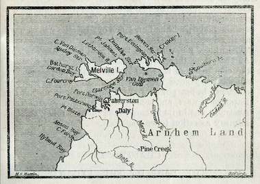
Map, Melville Island
... ...pine creek...Ballarat Heritage Services PO Box 2209 Bakery Hill Post Office goldfields map explorers exploration melville island tiwi islands arnhem land palmerston daly croker island bathurst island pine creek daly river Copy of a map from 'A Short History of Australia' by Ernest Scott. ...Copy of a map from 'A Short History of Australia' by Ernest Scott.map, explorers, exploration, melville island, tiwi islands, arnhem land, palmerston, daly, croker island, bathurst island, pine creek, daly river -
 Victorian Interpretive Projects Inc.
Photograph - Colour, LJ Gervasoni, Vince Gervasoni's Truck, Yandoit Creek, 2004, 26/06/2004
... Creek...Gervasoni...Vince gervasoni...Luigi Gervasoni...truck...Pine...Vincent Michael Gervasoni was the son of John Gervasoni and Catherine Cugley of 'Pine View' Yandoit Creek. John Gervasoni's father, Luigi Gervasoni, was born at San Gallo, Bergamo, Lombardy, Italy. ...An old truck parked in front of a corrugated iron shed at 'Pine View', Yandoit Creek. ...Yandoit Yandoit Creek Gervasoni Vince gervasoni Luigi Gervasoni truck Pine View An old truck parked in front of a corrugated iron shed at 'Pine View', Yandoit Creek. ...Vincent Michael Gervasoni was the son of John Gervasoni and Catherine Cugley of 'Pine View' Yandoit Creek. John Gervasoni's father, Luigi Gervasoni, was born at San Gallo, Bergamo, Lombardy, Italy. He was one of the earliest settlers at Yandoit Creek and contributed to the building of some of the drystone buildings.An old truck parked in front of a corrugated iron shed at 'Pine View', Yandoit Creek. yandoit, yandoit creek, gervasoni, vince gervasoni, luigi gervasoni, truck, pine view -
 Federation University Historical Collection
Letter, Letter from Northern Hercules No Liability to the Ballarat School of Mines, 28/03/1957
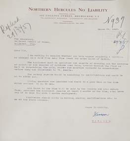
... Typed letter on Northern Hercules No Liability letterhead asking for a qualified assayer to work at the Pine Creek Gold Mine 160 miles south of Darwin. ...Ballarat School of Mines Northern Hurcules No Liability Northern Territory mining letterhead r.w. richards dick richards mining companies assayer Typed letter on Northern Hercules No Liability letterhead asking for a qualified assayer to work at the Pine Creek Gold Mine 160 miles south of Darwin. ...Many mining companies sought staff from the Ballarat School of Mines.Typed letter on Northern Hercules No Liability letterhead asking for a qualified assayer to work at the Pine Creek Gold Mine 160 miles south of Darwin. The letter was responded to by R.W. Richards, Principal of the Ballarat School of Minesballarat school of mines, northern hurcules no liability, northern territory, mining, letterhead, r.w. richards, dick richards, mining companies, assayer -
 Bendigo Historical Society Inc.
Slide - DIGGERS & MINING. THE CHINESE ON THE GOLD FIELDS, c1850s
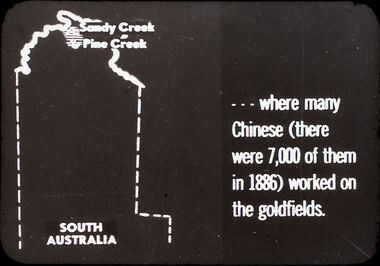
... Slide: Shows map of South Australia, Sandy Creek and Pine Creek are at the top of the map. Slide; reads . . . ...Slide: Shows map of South Australia, Sandy Creek and Pine Creek are at the top of the map. Slide; reads . . . ...Diggers & Mining. The Chinese on the Gold Fields. Slide: Shows map of South Australia, Sandy Creek and Pine Creek are at the top of the map. Slide; reads . . . Where many Chinese (there were 7,000 of them in 1886) worked on the goldfields. Markings: 3. Used as a teaching aid.hanimounteducation, tertiary, goldfields -
 Chelsea & District Historical Society Inc
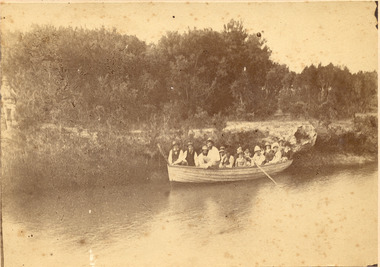
Photograph - Mr Hugh Brown and descendants, Family boat trip in Mordialloc Creek, 1882
... Pine Vale...Mordialloc Creek...Creek. Hugh Brown (1830-1930), born in Ireland, arrived in Adelaide in 1855 and in the Mordialloc district in 1856. Mr Brown brought land in 1866 and built his farmhouse “Pine Vale” in 1870 near the site of the present Mordialloc Secondary College (then part of the property) and extended his property when the swampland was made open for selection in 1871. ...Creek to almost the Aspendale Railway Station. The property was a market garden and orchard. Mr Brown took an active interest in the public life of the community, a Justice of the Peace; Councillor of Dandenong Shire for over 30 years, was twice Shire President; and a founding member of the Mordialloc Mechanics Institute. Hugh Brown Mordialloc pioneer Pine ...The members of the Brown family in a rowing boat on Mordialloc Creek. Hugh Brown (1830-1930), born in Ireland, arrived in Adelaide in 1855 and in the Mordialloc district in 1856. Mr Brown brought land in 1866 and built his farmhouse “Pine Vale” in 1870 near the site of the present Mordialloc Secondary College (then part of the property) and extended his property when the swampland was made open for selection in 1871. The property was a market garden and orchard. Hugh Brown married Zillah Baxter (1866) and they had six sons, five living to adulthood. The Brown family increased their land holding until they held a major part of the farmland between Mordialloc Creek to almost the Aspendale Railway Station. The property was a market garden and orchard. Mr Brown took an active interest in the public life of the community, a Justice of the Peace; Councillor of Dandenong Shire for over 30 years, was twice Shire President; and a founding member of the Mordialloc Mechanics Institute. Sepia photo of a adults in a large rowing boat on Mordialloc Creek, Mordialloc.hugh brown, mordialloc, pioneer, pine vale, mordialloc creek, row boat -
 Ballarat Heritage Services
Photograph - Black and White, World War One Postcard from John Joseph Gervasoni
... World War One Postcard from John Joseph Gervasoni to Kate Gervasoni (Cugley) of Pine View, Yandoit Creek....Ballarat Heritage Services PO Box 2209 Bakery Hill Post Office goldfields yandoit creek john joseph gervasoni world war one Kate Gervasoni Kate Cugley World War One Postcard from John Joseph Gervasoni to Kate Gervasoni (Cugley) of Pine View, Yandoit Creek. ...World War One Postcard from John Joseph Gervasoni to Kate Gervasoni (Cugley) of Pine View, Yandoit Creek.yandoit creek, john joseph gervasoni, world war one, kate gervasoni, kate cugley -
Federation University Historical Collection
Book, C.E. Bristow, Government Printer, Northern Territory of South Australia Government Geologist's Reports on Recent Mineral Discoveries, 1908
... Foolscap government geologist's Report including information on:- Pine Creek District; Brock's Creek, Anson Bay, Northern Territory Boring Operations Images Include: 'Mob of Blacks ad Tamarind Tree near Cliff Head, Anson Bay; Diamond Drill Boring Camp, near Cliff Head, Anson Bay, Wannomi Swamp; Daly River Crossing; Battery and Chinese Miners, Driffield Sketch Plan of the Mount Davis Copper FIeld, Sketch Plan Shewing POsition of Mineral Localities and Claims Near Wolfram Camp, Sketch PLan of the Pin Creek District Shewing Metalliferous Localities. ...Barker Library (top floor) Mount Helen goldfields h.y.l. brown mining boring aborigines aboriginal chinese south australia Foolscap government geologist's Report including information on:- Pine Creek District; Brock's Creek, Anson Bay, Northern Territory Boring Operations Images Include: 'Mob of Blacks ad Tamarind Tree near Cliff Head, Anson Bay; Diamond Drill Boring Camp, near Cliff Head, Anson Bay, Wannomi Swamp; Daly River Crossing; Battery and Chinese Miners, Driffield Sketch Plan of the Mount Davis Copper FIeld, Sketch Plan Shewing POsition of Mineral Localities and Claims Near Wolfram Camp, Sketch PLan of the Pin Creek District Shewing Metalliferous Localities. ...Foolscap government geologist's Report including information on:- Pine Creek District; Brock's Creek, Anson Bay, Northern Territory Boring Operations Images Include: 'Mob of Blacks ad Tamarind Tree near Cliff Head, Anson Bay; Diamond Drill Boring Camp, near Cliff Head, Anson Bay, Wannomi Swamp; Daly River Crossing; Battery and Chinese Miners, Driffield Sketch Plan of the Mount Davis Copper FIeld, Sketch Plan Shewing POsition of Mineral Localities and Claims Near Wolfram Camp, Sketch PLan of the Pin Creek District Shewing Metalliferous Localities. h.y.l. brown, mining, boring, aborigines, aboriginal, chinese, south australia -
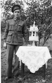 Ballarat Heritage Services
Photograph - Photograph - Black and White, Vince Gervasoni and his 21st birthday cake
... The photograph was taken in the back yard of his famile's Yandoit Creek farm 'Pine View'. ...The photograph was taken in the back yard of his famile's Yandoit Creek farm 'Pine View'. Vince Gervasoni and his 21st birthday cake Photograph Photograph - Black and White ...Vince was the youngest son of John and Catherine Gervasoni, and the grandson of Luigi Gervasoni. Black and white photograph of Vince Gervasoni in World War 2 AIF uniform, standing next to his 2 tier 21st birthday cake. The photograph was taken in the back yard of his famile's Yandoit Creek farm 'Pine View'. yandoit creek, vince gervasoni, birthday cake, world war 2 -
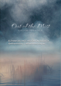 Eltham District Historical Society Inc
Book, Jenny Brown et al, Out of the Mist; Osborne Peninsula, 2024
... Contents: Welcome: The landform: The River: Aboriginal occupation: The Miners: North Warrandyte :The Subdivision: The Lowes: The Osbornes: The Last Osborne: The Elders: The Relics: Dray Track: Water Wheel"Kauri Plaque: River track: Pines: Windmill Creek Bridge: The Koornong School: The Houses" Man Cave: MidCentury Classic: Enduring Original" Masterwork: The Muddies: The State Park: The Saving of Koornong Reserve: The Landcare Story: Flora and Fauna: The Vulnerable, Endangered and threatened: Birds: Mammals: "Waring" the wombat: Reptiles: Fish: Invertebrates: Flora: Fire. ...Contents: Welcome: The landform: The River: Aboriginal occupation: The Miners: North Warrandyte :The Subdivision: The Lowes: The Osbornes: The Last Osborne: The Elders: The Relics: Dray Track: Water Wheel"Kauri Plaque: River track: Pines: Windmill Creek Bridge: The Koornong School: The Houses" Man Cave: MidCentury Classic: Enduring Original" Masterwork: The Muddies: The State Park: The Saving of Koornong Reserve: The Landcare Story: Flora and Fauna: The Vulnerable, Endangered and threatened: Birds: Mammals: "Waring" the wombat: Reptiles: Fish: Invertebrates: Flora: Fire. ...The Osborne Peninsula on the Yarra River at Warrandyte accommodates a limited number of properties and residents (70 households). The area is rich in geology and ecology, and an unusually rich endowment of human, built and creative history. Contents: Welcome: The landform: The River: Aboriginal occupation: The Miners: North Warrandyte :The Subdivision: The Lowes: The Osbornes: The Last Osborne: The Elders: The Relics: Dray Track: Water Wheel"Kauri Plaque: River track: Pines: Windmill Creek Bridge: The Koornong School: The Houses" Man Cave: MidCentury Classic: Enduring Original" Masterwork: The Muddies: The State Park: The Saving of Koornong Reserve: The Landcare Story: Flora and Fauna: The Vulnerable, Endangered and threatened: Birds: Mammals: "Waring" the wombat: Reptiles: Fish: Invertebrates: Flora: Fire. Published by the North Warrandyte (Osborne Peninsula) Landcare Group. Includes photos from EDHS collection.64 p. : ill., map ; 29.7 x 21 cm. (2 copies)yarra river, birrarung, dray track, fauna, geology, houses, indigenous history, koornong reserve, koornong school, lowe family, mining, mudbrick houses, north warrandyte, osborne family, warrandyte state park, water wheel, north warrandyte (osborne peninsula) landcare group, osborne peninsula -
 Eltham District Historical Society Inc
Photograph, Mr Yates, Clerk of the Course for the Diamond Creek Racing Club, c.1880
... Clerk of the Course, Diamond Creek Racing Club, Diamond Valley Story, Horse, Mr Yates, Pine Grove, Postmaster, Upper Diamond Creek..."Mr Yates of Pine Grove, Upper Diamond Creek was the local postmaster, and Clerk of the Course for the Diamond Creek Racing Club in the 1880s. ..."Mr Yates of Pine Grove, Upper Diamond Creek was the local postmaster, and Clerk of the Course for the Diamond Creek Racing Club in the 1880s. ...Photo from J. Sinclair reproduced on p92 of The Diamond Valley Story by Dianne H. Edwards, Shire of Diamond Valley 1979. "Mr Yates of Pine Grove, Upper Diamond Creek was the local postmaster, and Clerk of the Course for the Diamond Creek Racing Club in the 1880s. He is dressed for a meeting - the coat was scarlet. When racing ended at Diamond Creek in the 1890s he became Clerk of the Course at the Yarra Glen track."Black and white copy of photo printed on glossy photographic paper 30.5 x 40.5 cm (12 x 16 inch); image size approx. 18.5 x 28 cmclerk of the course, diamond creek racing club, diamond valley story, horse, mr yates, pine grove, postmaster, upper diamond creek -
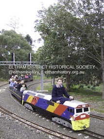 Eltham District Historical Society Inc
Photograph - Digital Photograph, Marguerite Marshall, Diamond Valley Railway, Eltham Lower Park, 7 September 2008
... On we go, past the original platform, along another route past busy Main Road through Pine Creek Station, over a bridge and through another tunnel with more screams of delight.Then a signal stops us before the ‘all clear’ to return to our original point of departure. ...On we go, past the original platform, along another route past busy Main Road through Pine Creek Station, over a bridge and through another tunnel with more screams of delight.Then a signal stops us before the ‘all clear’ to return to our original point of departure. ...Kids of all ages enjoy the Miniature Railway. Published: Nillumbik Now and Then / Marguerite Marshall 2008; photographs Alan King with Marguerite Marshall.; p163 On Sundays in Eltham thousands of children, mums, dads and grandparents can be seen travelling around Lower Eltham Park in tiny trains. They are among the two and half million passengers who have travelled on the Diamond Valley Railway since it officially began in 1961. The miniature railway originally operated from the 1940s at Chelsworth Park, Ivanhoe, until flooding caused it to be moved to the Eltham Lower Park in 1959. The railway is modelled on the 1920s era – the heyday of passenger rail travel – and the trains are built on a scale of two inches to the foot (1/6). Although not exact replicas, trains include models of the Spirit of Progress, Puffing Billy, The Overland, Dog Boxes, Vic Rail S class, G class and a NSW 81 Class. The three and a half kilometres of track is set amongst native plants and picnic areas. A friendly hoot or the clang of a bell occasionally punctuates the tranquillity as a train emerges from a treed bend with passengers excitedly waving to onlookers. For $3 the train takes you on a 13-minute two-kilometre ride. Passengers sit in single file in the narrow train, which clatters along tracks built to the scale of the Australian narrow gauge of three feet six inches (1.1m). These are used in Queensland, South Australia, Tasmania and Western Australia. Safety standards are stringently kept. Even before you buy a ticket notices tell you that you must wear closed shoes. You can even borrow these, and you are given a pair of socks for the ride! Blue-overalled volunteers check tickets, see you aboard, and drive the train. They are mainly retired men who can at last devote their time to what little boys dream of – playing with trains. Passengers are instructed in safe behaviour, then the station master waves a white flag and off we go. The guard sits at the back with his whistle and green flag at the ready. The winding track, fringed by native trees and bushes planted by volunteers, stands on crown land managed by Nillumbik Council. The train clatters along the track and crosses a bridge over a drain elevated by name to The Blow Fly Creek. We pass by Meadmore Junction at a speed of three kilometres an hour. Then on through a tunnel, accompanied by squeals of delight, and after a few moments of blackness, light glimmers at the end. On we go, past the original platform, along another route past busy Main Road through Pine Creek Station, over a bridge and through another tunnel with more screams of delight.Then a signal stops us before the ‘all clear’ to return to our original point of departure. The railway services its passengers – the largest number of any miniature railway in Australia – with a fleet including: six diesel locomotives, three steam locomotives, eight sets of passenger cars and one battery electric Dog Box set. Members also privately own 20 locomotives and powered carriage sets as well as four carriage sets.1 All the trains are stored on-site in workshops, sheds and a tunnel. The railway is entirely run by volunteers, so that all ticket money is used for maintenance and extensions, and some goes to local charities. Since 1991, the entire railway has been rebuilt, including an upgraded signalling system. About half of the 120 volunteer members are active with about 35 working each Sunday, and a dozen or so working every Wednesday. Members are trained to positions of station assistant, booking officer, train guard, train driver or signalman. Members construct new carriages and locomotives as well as maintaining track, signalling and rolling stock.This collection of almost 130 photos about places and people within the Shire of Nillumbik, an urban and rural municipality in Melbourne's north, contributes to an understanding of the history of the Shire. Published in 2008 immediately prior to the Black Saturday bushfires of February 7, 2009, it documents sites that were impacted, and in some cases destroyed by the fires. It includes photographs taken especially for the publication, creating a unique time capsule representing the Shire in the early 21st century. It remains the most recent comprehenesive publication devoted to the Shire's history connecting local residents to the past. nillumbik now and then (marshall-king) collection, diamond valley railway, eltham lower park -
 Kiewa Valley Historical Society
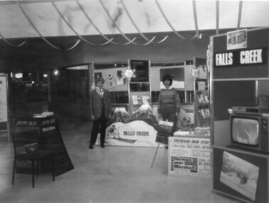
Photographs - Mt Beauty, Tawonga South and Falls Creek
... Creek 15. Two girls 16. Mt Beauty - Home Improvement Centre 17. Tawonga District Hospital/Mt Beauty Hospital before the Nursing Home - removing pine trees 18. ...Creek 15. Two girls 16. Mt Beauty - Home Improvement Centre 17. Tawonga District Hospital/Mt Beauty Hospital before the Nursing Home - removing pine trees 18. ...Mt Beauty and Tawonga South are in the Kiewa Valley Mt Beauty and Tawonga are in the Kiewa Valley. Many of these photos record people who lived in these towns and their activities.Collection of black and white photos of Mt Beauty and Tawonga. Most are labelled (and some include names but no dates) in pencil on the back.Varying sizes. 1. Marketing Falls Creek 2. Driver Education Car Presentation- Mt Beauty Secondary College 3. Start of Mt Beauty Marathon 4. Mount Beauty Paramedical Day Care Centre 5. Falls Creek - Original Halley's Comet 6. Falls Creek - Original Snow-making on Twin Towers 7. Group of 10 girls 8. Mt Beauty Primary School - Tidy Towns Competition 9.Mt Beauty Primary School 10. Start of Mt Beauty Marathon 11. Lou Leiberman - Local Member 12. Bank Manager, Commonwealth Bank on left. 13. Driver Education Car - Mt Beauty Secondary College 14. Original Snow-making on Twin Towers at Falls Creek 15. Two girls 16. Mt Beauty - Home Improvement Centre 17. Tawonga District Hospital/Mt Beauty Hospital before the Nursing Home - removing pine trees 18. Water Board Installation at Tawonga South (outside Rookes house) 19. Dederang Catholic Church 20. Two men (names on back) 21. Tawonga Store 22. Mt Beauty - old butcher shop on right hand side 23.Tidy Towns Mt Beauty Labelled in pencil on the backmt beauty, tidy towns, driver education, marathon, falls creek -
 Bairnsdale RSL Sub-Branch Inc.
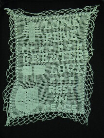
Momento Doily, Resident "Penderscourt", Early 20th Century
... Bairnsdale RSL Sub-Branch Inc. 2 Forge Creek Rd Bairnsdale gippsland handcraft lone pine doily hand crochet cloth doily world war one handcraft love token momento anzac cove Embroided in the momento "LONE/PINE/GREATER/LOVE/REST/IN/PEACE". ...Hand •crochet cloth Doily, probably cotten, Dedication Inscription,Lone Pine Greater Love Lost rest in peace Pine tree, Flags / banners, Shield with cross, Embroided in the momento "LONE/PINE/GREATER/LOVE/REST/IN/PEACE".handcraft, lone pine, doily, hand crochet cloth doily, world war one handcraft, love token, momento anzac cove -
Eltham District Historical Society Inc
Document - Folder, North, Edley
... Creek...Eltham Railway Station...Judge Book Village...Fred Warne...Edley North...Caroline North...Eltham Cemetery....Violet Alice Dobson (nee North)...Willow Farm Eltham...Edley North family tree...Walter John Dobson family tree...Nancy Chandler (nee Williamson)...Pine...Marjorie North Tralford Norman Sherbourne Road Montmorency Looker Road Montmorency Briar Hill Montmorency Catholic Ladies College Merton Hall Melbourne Girls Grammar School Ivanhoe Girls Grammar School Wesley College Meruka Park St Helena Road St Faith's Anglican Church Montmorency William Sapsford Floods in Eltham Joseph Benjamin North Leon Lambert Melbourne Symphony Orchestra Karingal Drive Meruka House Alan Gardner Lucinda Matilda North Tralford E North Camille D North Montmorency Cricket Club Diamond Creek Eltham Railway Station Judge Book Village Fred Warne Edley North Caroline North Eltham Cemetery. Violet Alice Dobson (nee North) Willow Farm Eltham Edley North family tree Walter John Dobson family tree Nancy Chandler (nee Williamson) Pine lodge Elijah North Newspaper clippings, A4 photocopies, etc North, Edley Document Folder ...Joseph Benjamin North was a well-known professional musician in Melbourne in late 1800 to mid 1900s, teaching music and playing in what became the Melbourne Symphony Orchestra. He married Lucinda Matilda and their children were Tralford E and Camille D. With friend Leon Lambert, North purchased 60 acres of land around Karingal Drive and Sherbourne Road and built two houses; they paid for a wooden bridge for access. North eventually sold his house to a family named Green but later the land was sold to the Shire of Eltham, and it is now known as Meruka Park, and the house, Meruka House; Alan Gardner named the park. After Lambert's death, his property was bought by Fred Warne. Edley North was born in 1835, and died 26 March 1923; he married Caroline North, born 1835, died 23 July 1922. Edley's family migrated from England in 1859, settling in Adelaide. He was granted an allotment of 221 acres on Phillip Island 1868-1870. on 7 April 1874 he travelled to Pine Lodge and later moved his wife and five children. He and Caroline later moved to a small farm, Willow Grove in Eltham, purchased between 1905 and 1910 (first mentioned in the rate book in 1908 as being a house and 10 acres on Susan Street, and would also have had frontage on Brougham Street); Their daughter Violet Alice inherited it; she married Walter J Dobson around 1921; he died on 25 March 1948 aged 77 and Violet on 4 January 1947. Willow Grove was later purchased by A George and P Audrey Hester April/May 1947. Edley, Caroline and Violet are all buried in Eltham Cemetery. Marjorie Mary North was born in 1909 ; the family travelled in a horse-drawn waggon from Fitzroy to spend weekends in their little holiday house in Sherbourne Road on 10 acres of land. In 1933, she married Tralford Norman whose parents owned 62 acres of land including Meruka Park. Marjorie and Tralford lived in Looker Road, Montmorency; she died 7 February 2003. Contents Newspaper article: "When life centred on a weekender", Diamond Valley News, 25 September 1984, memories of Montmorency of Marjorie North. Newspaper article: "Worse floods seem likely", Diamond Valley News, 25 September 1984, floods in Eltham Handwritten notes: Information by Marjorie North's about her grandmother, September 1989. Handwritten and typed transcript: "J. B. North", by Marjorie North, history of Joseph Benjamin North. Letter: From Monash University to Marjorie North, 15 November 1989, being unable to assist with her enquiry about the meaning of name [unspecified in the letter but possibly Meruka] Letter: June Stanton (nee Hester) to Eltham District Historical Society, 17 February 1993, seeking information on her great grandfather Edley North and wife Caroline. Christmas card [attached to letter from June Stanton]: Line drawing Eltham Primary School 1856, text history of school Letter: Eltham Historical Society to June Hester, 11 June 1993, providing information held by the Society. Letter: Nancy Chandler (nee Williamson) to Jo McCormick 18 March 2001, providing information about Edley and Carline North, her great grandparents. Email: Patsy Moppett to Eltham District Historical Society October 2010: A photograph of Edley and Caroline North found, wish to return it to family. Family tree: North/Dobson family. Death notice: Marjorie May North, died 7 February 2003.Newspaper clippings, A4 photocopies, etcmarjorie north, tralford norman, sherbourne road montmorency, looker road montmorency, briar hill, montmorency, catholic ladies college, merton hall, melbourne girls grammar school, ivanhoe girls grammar school, wesley college, meruka park, st helena road, st faith's anglican church montmorency, william sapsford, floods in eltham, joseph benjamin north, leon lambert, melbourne symphony orchestra, karingal drive, meruka house, alan gardner, lucinda matilda north, tralford e north, camille d north, montmorency cricket club, diamond creek, eltham railway station, judge book village, fred warne, edley north, caroline north, eltham cemetery., violet alice dobson (nee north), willow farm eltham, edley north family tree, walter john dobson family tree, nancy chandler (nee williamson), pine lodge, elijah north -
 Eltham District Historical Society Inc
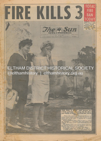
Newspaper - Newspaper articles, Sun News-Pictorial, Fire Kills 3, The Sun News-Pictorial, Thursday, March 4, p1, 1965
... Pine...Bushfire damage – buildings...Back Gully...Gippsland...Glenmaggie...Briagolong...George John Crowe...John Lawrence Coleman...William John Elwers...Creek...Tom Fielding Collection Victorian Bushfires - 1965 Victorian Bushfires – 1965 Glen Park Road Eltham North Sunny Pine Bushfire damage – buildings Back Gully Gippsland Glenmaggie Briagolong George John Crowe John Lawrence Coleman William John Elwers Creek Road Wattle Glen Bill Guy Digital scan of original pages from newspaper Fire Kills 3, The Sun News-Pictorial, Thursday, March 4, p1 Newspaper Newspaper articles Sun News-Pictorial ...Various news articles pertaining to the January 1965 Victorian bushfires specifically with a focus on fires at Eltham North. Specific Eltham Shire districts mentioned include Eltham North on page 1, 2, 3, 28-29 • Fire Kills 3, p1 (Illust.) • Fire on their heel, p2 (Illust.) • Flames catch, kill 3 as they run: 12 house go, p3 (Illust.) • It doubled back, p3 • Helpers highly praised, p3 • Blaze kills 100 puppies, p3 (Illust.) • Scenes from Eltham’s Black Wednesday, pp28-29 (Illust.) tom fielding collection, victorian bushfires - 1965, victorian bushfires – 1965, glen park road, eltham north, sunny pine, bushfire damage – buildings, back gully, gippsland, glenmaggie, briagolong, george john crowe, john lawrence coleman, william john elwers, creek road, wattle glen, bill guy -
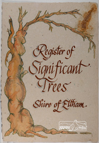 Eltham District Historical Society Inc
Work on paper - Folio, Register of Significant Trees, Shire of Eltham, c.1993
... arthurs creek road, blue gum (eucalyptus globulus), canary island pine (pinus canariensis), couties road, donaldsons oak, donaldsons road, eltham, english oak (quercus robur), eucalyptus melliodora, graysharps road, hurst tree, hurstbridge, ironbark (eucalyptus tricarpa), ironbark hill, kangaroo ground, kangaroo ground-kinglake road, laughing waters road, panton hill hotel, panton hill, parsons road, significant trees register, sonia van bodegraven, sonjart, stone pine (pinus pinea). atlantic cedar (cedrus atlantica), wippells oak, yellow box gum (eucalyptus melliodora), yellow box gum...The buildings and trees listed were: Buildings: 250 Bolton Street Eltham (former Walter Withers home) "Rosehill" - Bonds Road Lower Plenty St Andrews Church of England - St Andrews "Montsalvat" - Hillcrest Avenue Eltham St Margarets Church and former vicarage - Pitt Street Eltham Presbyterian Church - Kangaroo Ground Parks and Environment Office (former police quarters) Main Road Eltham Former Court House - Main Road Eltham "Shillinglaw Cottage" - Main Road Eltham "The Robins" - Kangaroo Ground Road Warrandyte Trees: "Donaldsons Oak" - Donaldsons Road Kangaroo Ground Yellow Box - Laughing Waters Road Eltham Yellow Box - Arthurs Creek Road Hurstbridge Wippells Oak - St Andrews Road Kanqaroo Road Pines and Cedar - Hurst family cemetery Greysharps Road Hurstbridge Yellow Box - Parsons Road Eltham A large Blue Gum at Panton Hill has been listed but has recently died (1991). ...The buildings and trees listed were: Buildings: 250 Bolton Street Eltham (former Walter Withers home) "Rosehill" - Bonds Road Lower Plenty St Andrews Church of England - St Andrews "Montsalvat" - Hillcrest Avenue Eltham St Margarets Church and former vicarage - Pitt Street Eltham Presbyterian Church - Kangaroo Ground Parks and Environment Office (former police quarters) Main Road Eltham Former Court House - Main Road Eltham "Shillinglaw Cottage" - Main Road Eltham "The Robins" - Kangaroo Ground Road Warrandyte Trees: "Donaldsons Oak" - Donaldsons Road Kangaroo Ground Yellow Box - Laughing Waters Road Eltham Yellow Box - Arthurs Creek Road Hurstbridge Wippells Oak - St Andrews Road Kanqaroo Road Pines and Cedar - Hurst family cemetery Greysharps Road Hurstbridge Yellow Box - Parsons Road Eltham A large Blue Gum at Panton Hill has been listed but has recently died (1991). ...In 1983, the National Trust advised the Shire of Eltham that it was investigating a number of trees within the shire which had been nominated for recording the Register of Significant Trees of Victoria. The trees involved were described in the Shire of Eltham Historical Society Newsletter No. 29, March 1983 as follows:- 1. Eucalyptus melliadora (Yellow box) . a) An outstanding mature specimen 42 metres high in Laughing Waters Road, Eltham. b) Another mature specimen in Arthurs Creek road, Hurstbridge is reported to be the tree under which the bushranger Robert Bourke was tied after he shot and killed Henry Hurst in 1866 . 2. Quercus robur (English Oak). a) "Donaldson's Oak", Donaldsons Road, Kangaroo Ground was planted by John Donaldson from seed collected from Windsor Great Park in 1878. b) "Wippells Oak". This now misshapen tree is located on the St. Andrews Road near the Kangaroo Ground Fire Station. Its origins may have been similar to Donaldson's Oak, and as a young tree it apparently slipped from higher up the hill during wet weather. Both oaks are of local historical importance. 3. Eucalyptus globulus (Blue Gum). A large mature specimen at the corner of the Kangaroo Ground-St. Andrews Road and Bakehouse Road, Panton Hill. 4. Plantanas acerifolia (Plane tree) A number of trees forming the Avenue of Honour to Eltham's First World War soldiers along Main Road between Dalton and Pitt Streets, Eltham. 5. Pinus canariensis (Canary Island Pine), Pinus pinea, (Stone pine) and Cedras altlantica, (Cedar) These trees are located at the Hurst family graves in the grounds of the Hurstbridge Pre-school Centre. In 1991 the Shire of Eltham introduced controls into its planning scheme to protect sites of architectural, historic or conservation interest and significant trees. The controls were approved by the Minister for Planning and Housing. As advised in the Shire of Eltham Historical Society Newsletter No. 78, May 1991, a planning permit is required to demolish or alter any listed building or to destroy, lop or remove any listed tree. Provision is made for comments to be obtained from the National Trust or Historic Buildings Council in considering any applications. The buildings and trees listed were: Buildings: 250 Bolton Street Eltham (former Walter Withers home) "Rosehill" - Bonds Road Lower Plenty St Andrews Church of England - St Andrews "Montsalvat" - Hillcrest Avenue Eltham St Margarets Church and former vicarage - Pitt Street Eltham Presbyterian Church - Kangaroo Ground Parks and Environment Office (former police quarters) Main Road Eltham Former Court House - Main Road Eltham "Shillinglaw Cottage" - Main Road Eltham "The Robins" - Kangaroo Ground Road Warrandyte Trees: "Donaldsons Oak" - Donaldsons Road Kangaroo Ground Yellow Box - Laughing Waters Road Eltham Yellow Box - Arthurs Creek Road Hurstbridge Wippells Oak - St Andrews Road Kanqaroo Road Pines and Cedar - Hurst family cemetery Greysharps Road Hurstbridge Yellow Box - Parsons Road Eltham A large Blue Gum at Panton Hill has been listed but has recently died (1991). In 1993 work by Council Parks and Environment staff and volunteers resulted in the preparation of a Significant Tree Register listing forty-one trees or groups of trees. According to Shire of Eltham Historical Society Newsletter No. 91, March 1993, a similar number remained to be assessed for inclusion in the register. There is a wide range of indigenous and planted trees on private and public land and extending through the Shire of Eltham from Lower Plenty to Kinglake. Most can be viewed from publicly accessible locations. The Significant Tree Register lists 41 trees or groups of trees throughout the Shire. It contains a wide range of naturally occurring and planted trees. They have been assessed according to eleven criteria including size, age, rarity, historical value and the like. The list includes large old Red Gums at Lower Plenty, historic Oaks at Kangaroo Ground and Mountain Ash at Kinglake. The register includes a set of slides showing each tree. Garry Bartlett of the Council's Parks and Environment Section and Faye Shepherd were extensively involved in establishment of the register (Newsletter No. 93, November 1993). In 1999 Niliumbik planners prepared an amendment to the Planning Scheme to provide protection for approximately 200 of the places listed in the heritage studies and also in the Significant Tree Register commenced by the Eltham Council (Eltham District Historical Society Newsletter No. 127, July 1999. In 2004, The Register of Significant Trees was presented to the Eltham District Historical Society by Nillumbik Shire Council as part of a wider collection of of its memorabilia of the former Eltham Shire Council (EDHS Newsletter No. 159, July 2004. Album of loose handmade paper sheets contained within a handmade slip cover constructed of handcrafted card with encapsulated flora material (flowers, vines, ferns) and tinted. Each page also contains an embedded/adhered fern leaf also tinted with lacqueur or similar, text as appropriate in ink by hand calligraphy. Each page also has a white protective sheet cut to size and adhered to back surface with sticky tape and folded over face of page. Pages variously have photographs and coloured masks adhered with a gum resin. Over time much of this resin has let go and photos/masks have been reattached using acid free archival safe adhesive. 15 pages 41 x 29 cm inclusive of 3 blank pages. Slip case 42 x 30 x 1 cm; face cover of slip case has broken off at left hand margin as insufficient depth/flexibility for contents.arthurs creek road, blue gum (eucalyptus globulus), canary island pine (pinus canariensis), couties road, donaldsons oak, donaldsons road, eltham, english oak (quercus robur), eucalyptus melliodora, graysharps road, hurst tree, hurstbridge, ironbark (eucalyptus tricarpa), ironbark hill, kangaroo ground, kangaroo ground-kinglake road, laughing waters road, panton hill hotel, panton hill, parsons road, significant trees register, sonia van bodegraven, sonjart, stone pine (pinus pinea). atlantic cedar (cedrus atlantica), wippells oak, yellow box gum (eucalyptus melliodora), yellow box gum -
Glen Eira Historical Society
Document - Glen Orme Avenue, 2, McKinnon
... Pine Grove... Pinegrove... Elster Creek...Landells Rosalind Bick David Railway Park Glen Orme Avenue Glenorme Avenue McKinnon Pine Grove Pinegrove Elster Creek Murray Road Baker Samuel Baker F J Morris J R Dewhurst Edward Y Jamrich B Dendy Henry Were J B Bullock Hilary Document Glen Orme Avenue, 2, McKinnon ...A one page typed research note by Rosalind Landells of the Brighton Historical Society regarding 2 Glen Orme Avenue / Pinegrove, McKinnon, dated 10/07/1991. The note lists the previous owners of the property and gives a brief history of the land. The file also includes one page of handwritten, undated and unattributed working notes.landells rosalind, bick david, railway park, glen orme avenue, glenorme avenue, mckinnon, pine grove, pinegrove, elster creek, murray road, baker samuel, baker f j, morris j r, dewhurst edward y, jamrich b, dendy henry, were j b, bullock hilary -
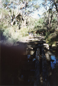 Halls Gap & Grampians Historical Society
Photograph - Coloured, C 1980s
... Pines" campground. STRUCTURES Bridges QUARRYING Heatherlie The photo is a "front on" of a derelict trestle bridge crossing a shallow creek; many sleepers are missing and thick bush and trees surround the bridge. ...This is a photo of one of the trestle bridges on the Heatherlie Quarry train line. The bridge is located near the current location of "The Pines" campground.The photo is a "front on" of a derelict trestle bridge crossing a shallow creek; many sleepers are missing and thick bush and trees surround the bridge. There are four adults at the end of the bridge, one standing and three seatede. The bottom left hand side of the photo is blurredstructures, bridges, quarrying, heatherlie -
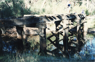 Halls Gap & Grampians Historical Society
Photograph - Coloured, C 1980s
... Pines" campground. STRUCTURES Bridges QUARRYING Heatherlie Photo shows an angle a derelict bridge with many sleepers missing. Thick bush and trees on left side with weeds in the front. The bridge is over a shallow creek ...This is a photo of one of the trestle bridges on the Heatherlie Quarry train line. It is located near the current site of "the Pines" campground.Photo shows an angle a derelict bridge with many sleepers missing. Thick bush and trees on left side with weeds in the front. The bridge is over a shallow creek. At the far end of the bridge a man wearing a pink cap and blue jumper stands looking towards camera. Three adults are seated and partly out of picture.structures, bridges, quarrying, heatherlie -
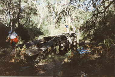 Halls Gap & Grampians Historical Society
Photograph - Coloured, C 1980s
... Pines" campground. STRUCTURES Bridges QUARRYING Heatherlie Photo is of a derelict trestle bridge over a shallow creek, taken on an angle. ...This is a photo of one of the trestle bridges on the Heatherlie Quarry train line. It is located near the current site of "the Pines" campground.Photo is of a derelict trestle bridge over a shallow creek, taken on an angle. There are many sleepers missing and the bridge is surrounded by thick bush and trees. There is bracken in the foreground. A woman wearing a blouse made of material with a white background with a colourful pattern, blue jeans, a white "golf shade" and a red jumper ot jacket tied around her waist is walking on the near side of the bridge. Two men and two women are standing at the opposite end.structures, bridges, quarrying, heatherlie -
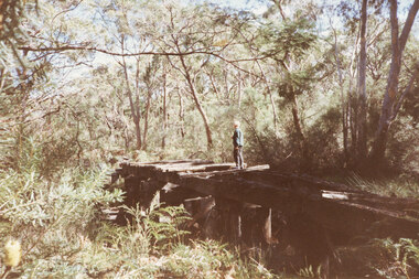 Halls Gap & Grampians Historical Society
Photograph - Coloured, C 1980s
... Pines" campground. The woman on the bridge is Janet Witham. STRUCTURES Bridges QUARRYING Heatherlie Photo is of a derelict trestle bridge over a shallow creek, taken on an angle. ...This is a photo of one of the trestle bridges on the Heatherlie Quarry train line. It is located near the current site of "the Pines" campground. The woman on the bridge is Janet Witham.Photo is of a derelict trestle bridge over a shallow creek, taken on an angle. There are many sleepers missing and the bridge is surrounded by thick bush and trees. There is bracken in the left foreground. A woman wearing a blue top and grey/brown slacks.structures, bridges, quarrying, heatherlie