Showing 937 items matching "platform"
-
 Buninyong & District Historical Society
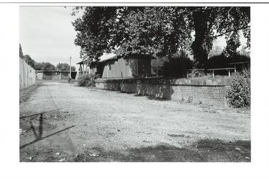
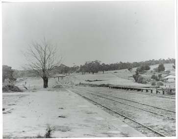
Photograph - B/W photograph, Mr C J Brooks, Buninyong Railway Station platform, (built 1889), 9 April 1994
... Buninyong Railway Station platform, (built 1889)......Platform...Remains of Buninyong Railway Station platform, line closed 1947...B/W photo remains Buninyong Railway Station platform, (built 1889) Looking towards Forest Street down former railway track, platform on right, tennis club building, elm tree, tennis court fence on left...Buninyong & District Historical Society Old Court House, Buninyong Town Hall 313 Learmonth Street Buninyong goldfields Remains of Buninyong Railway Station platform, line closed 1947 Only remains of Railway station Buninyong Bunny Railway Platform B/W photo remains Buninyong Railway Station platform, (built 1889) Looking towards Forest Street down former railway track, platform on right, tennis club building, elm tree, tennis court fence on left Buninyong Railway Station platform, (built 1889) Photograph B/W photograph Mr C J Brooks ...Remains of Buninyong Railway Station platform, line closed 1947Only remains of Railway stationB/W photo remains Buninyong Railway Station platform, (built 1889) Looking towards Forest Street down former railway track, platform on right, tennis club building, elm tree, tennis court fence on leftbuninyong, bunny, railway, platform -
 Buninyong & District Historical Society
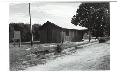
Photograph - B/W photograph, Mr C J Brooks, Buninyong Railway Station platform, (built 1889), 9 April 1994
... Buninyong Railway Station platform, (built 1889)......Platform...Remains of Buninyong Railway Station platform, line closed 1947...B/W photo remains Buninyong Railway Station platform, (built 1889) sign on left, power pole and Tennis Club shed, elm tree behind right....Buninyong & District Historical Society Old Court House, Buninyong Town Hall 313 Learmonth Street Buninyong goldfields Remains of Buninyong Railway Station platform, line closed 1947 Only remains of Railway station Buninyong Bunny Railway Platform B/W photo remains Buninyong Railway Station platform, (built 1889) sign on left, power pole and Tennis Club shed, elm tree behind right. ...Remains of Buninyong Railway Station platform, line closed 1947Only remains of Railway stationB/W photo remains Buninyong Railway Station platform, (built 1889) sign on left, power pole and Tennis Club shed, elm tree behind right.buninyong, bunny, railway, platform -
 Federation University Historical Collection
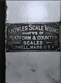
Photograph - Colour Photograph, Knowles Platform Scales, c1900
... Knowles Platform Scales...Photograph of a name plate from platform scales...Knowles Scale Works manf'r's of platform & counter scales Lowell, Mass.U.S.A....Photograph of a name plate from platform scales Knowles Platform Scales Photograph Colour Photograph ...Photograph of a name plate from platform scalesKnowles Scale Works manf'r's of platform & counter scales Lowell, Mass.U.S.A.platform scales, counter scales, knowles scale works, scientific objects -
 Ringwood and District Historical Society
Photograph, Mansourah Picture Framing, Building Heathmont Railway Station Platform by Wieland Brothers 1926, 1926
... Building Heathmont Railway Station Platform by Wieland Brothers 1926...Framed photograph with inscription - Building Heathmont Railway Station Platform by Wieland Brothers 1926....Building Heathmont Railway Station Platform by Wieland Brothers 1926....Building Heathmont Railway Station Platform by Wieland Brothers 1926. Framed photograph with inscription - Building Heathmont Railway Station Platform by Wieland Brothers 1926. ...Peter Le Get found three framed photos of Heathmont view in a Heathmont Opportunity Shop. Previous owners unknown.Framed photograph with inscription - Building Heathmont Railway Station Platform by Wieland Brothers 1926.Building Heathmont Railway Station Platform by Wieland Brothers 1926. -
 Buninyong & District Historical Society
Photograph - Photo of Original Photograph, Wal Larsen, B/W photo of Buninyong Railway Station platform, looking north, in June 1940, June 1940
... B/W photo of Buninyong Railway Station platform, looking north, in June 1940......Platform...B/W photo of Buninyong Railway Station platform, looking north in June 1940...Buninyong Railway Bunny Cutting Station Platform B/W photo of Buninyong Railway Station platform, looking north in June 1940 B/W photo of Buninyong Railway Station platform, looking north, in June 1940 Photograph Photo of Original Photograph Wal Larsen ...Railway and surrounds in 1940.B/W photo of Buninyong Railway Station platform, looking north in June 1940buninyong, railway, bunny, cutting, station, platform -
 Lakes Entrance Historical Society
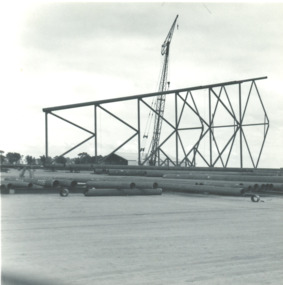
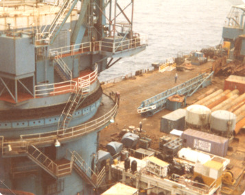
Photograph - Oil rig at Barry Beach, Marie Fish, first oil/gas platform, Barry Beach South Gippsland Victoria, 1968 c
... first oil/gas platform, Barry Beach South Gippsland Victoria...Marlin Platform...Black and white photograph of jacket of first oil/gas platform being built at Barry Beach South Gippsland Victoria. ...Marlin Platform Oil and Gas Industry Engineering Social History Black and white photograph of jacket of first oil/gas platform being built at Barry Beach South Gippsland Victoria. ...Marlin PlatformBlack and white photograph of jacket of first oil/gas platform being built at Barry Beach South Gippsland Victoria. Also two similar black and white photographs taken at same time at different angles. oil and gas industry, engineering, social history -
 Stawell Historical Society Inc
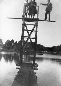
Photograph, Cato Lake diving platform with people
... Cato Lake diving platform with people...People standing on Diving Tower and photo showing walkway to the platform over the lake. c 1932....Cato Lake diving platform with 4 people standing on diving tower. ...Stawell Historical Society Inc 46 Longfield St Stawell grampians People standing on Diving Tower and photo showing walkway to the platform over the lake. c 1932. stawell Cato Lake diving platform with 4 people standing on diving tower. ...People standing on Diving Tower and photo showing walkway to the platform over the lake. c 1932.Cato Lake diving platform with 4 people standing on diving tower. A male is standing out on the diving board and 3 women on the tower. c 1932stawell -
 Wodonga & District Historical Society Inc
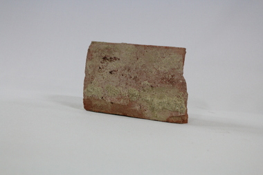
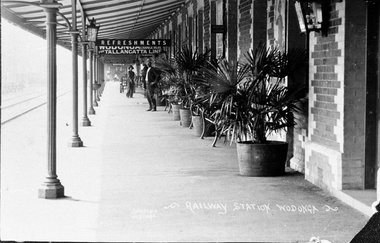
Functional object - Wodonga Station Platform Brick
... Wodonga Station Platform Brick...The original Wodonga Station, located in the middle of the city, was closed on 9 November 2008 as part of the Wodonga rail bypass project. The station platform was largely removed and the area has been redeveloped as part of the Junction precinct....The brick formed part of the platform at the original Wodonga Railway Station prior to its demolition as part of the Wodonga bypass development....Wodonga Station Platform Brick Functional object Wodonga Station Platform Brick ...The Wodonga rail line and railway station opened in November 1873 when the section of the line from Wangaratta was completed. The expansion of the railways to the northeast of Victoria occurred after the Victorian Government took over the railways in 1867 and the trains serviced large towns such as Seymour, Wangaratta and Wodonga, as well as smaller towns along the way. The original Wodonga Station, located in the middle of the city, was closed on 9 November 2008 as part of the Wodonga rail bypass project. The station platform was largely removed and the area has been redeveloped as part of the Junction precinct.This brick has local and state historical significance as the railways played a critical part in opening up the interior of Australia for commerce, transportation and settlement. It enabled Wodonga to develop as an important centre for social and commercial purposes.An old traditional brick with some joining mortar / concrete still attached. The brick formed part of the platform at the original Wodonga Railway Station prior to its demolition as part of the Wodonga bypass development.wodonga, railways, railway bypass, northeast victoria, vline -
 Federation University Historical Collection
Instrument - Scientific Instrument, Knowles Platform Scales, c1900
... Knowles Platform Scales...Knowles Scale Works manf'r's of platform & counter scales Lowell, Mass.U.S.A....Knowles Platform Scales Instrument Scientific Instrument ...Purchased at about the same time as the steam engine (cat. Non> 4066) for use with the friction brake that measured the steam engine output. Knowles Scale Works manf'r's of platform & counter scales Lowell, Mass.U.S.A.platform scales, counter scales, knowles scale works, scientific objects -
 City of Whittlesea
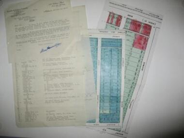
Document - Correspondence, Station Entrance and Railway Platform Estate, 1937
... Station Entrance and Railway Platform Estate...Letter from Ellison, Hewison & O'Collins Solicitors, Melbourne to the Shire of Whittlesea in reponse to a request for the names and addresses of the purchasers of blocks of land on the Station Entrance Estate and Railway Platform Estate, Thomastown. Both estates where originally subdived and sold in the mid 1920s. ...Letter from Ellison, Hewison & O'Collins Solicitors, Melbourne to the Shire of Whittlesea in reponse to a request for the names and addresses of the purchasers of blocks of land on the Station Entrance Estate and Railway Platform Estate, Thomastown. ...Letter from Ellison, Hewison & O'Collins Solicitors, Melbourne to the Shire of Whittlesea in reponse to a request for the names and addresses of the purchasers of blocks of land on the Station Entrance Estate and Railway Platform Estate, Thomastown. Station Entrance and Railway Platform Estate Document Correspondence ...Letter from Ellison, Hewison & O'Collins Solicitors, Melbourne to the Shire of Whittlesea in reponse to a request for the names and addresses of the purchasers of blocks of land on the Station Entrance Estate and Railway Platform Estate, Thomastown. Both estates where originally subdived and sold in the mid 1920s. The collection includes a letter, a list of owners and their address details and the lot they own, and plans of both estates, which have been cut out of the original estate sale posters. Streets include High Street (Epping Road), Mount View Road, Pleasant Road, Central Avenue, Highlands Road and Main Street, ThomastownLetter, paper 3 pages, 2 plans. Letter from Ellison, Hewison & O'Collins Solicitors, Melbourne to the Shire of Whittlesea in reponse to a request for the names and addresses of the purchasers of blocks of land on the Station Entrance Estate and Railway Platform Estate, Thomastown. -
 Brighton Historical Society
Shoes, Platform shoes, 1970s
... Platform shoes...Pair of silver holographic platform open-toed shoes. ...Platform shoes Shoes Tip Toe ...Pair of silver holographic platform open-toed shoes. Label, woven black on white: TIP toeplatform shoes, 1970s, tip toe -
 Lakes Entrance Historical Society
Photograph, Jack Donnelly, Oil drilling platform, Bass Strait, 1975 c
... Oil drilling platform, Bass Strait...Colour photograph on board a drilling platform in Bass Strait...Lakes Entrance Historical Society 4 Marine Parade Lakes Entrance gippsland Oil and Gas Industry Engineering Bass Strait Colour photograph on board a drilling platform in Bass Strait Oil drilling platform, Bass Strait Photograph Jack Donnelly ...Colour photograph on board a drilling platform in Bass Straitoil and gas industry, engineering, bass strait -
 Ringwood and District Historical Society
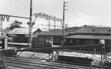
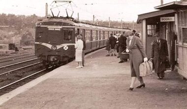
Photograph, Ringwood Railway Station number 2 platform ramp being developed 1963
... Ringwood Railway Station number 2 platform ramp being developed 1963...Typed below photograph, "Building ramp to No.2 platform Ringwood Railway Station, 1963"....Ringwood and District Historical Society 125A Warrandyte Road Ringwood North melbourne Typed below photograph, "Building ramp to No.2 platform Ringwood Railway Station, 1963". Black and white photograph Ringwood Railway Station number 2 platform ramp being developed 1963 Photograph ...Black and white photographTyped below photograph, "Building ramp to No.2 platform Ringwood Railway Station, 1963". -
 Wodonga & District Historical Society Inc
Photograph - Wodonga Railway Station Platform, Thomas Bonsema, c1910
... Wodonga Railway Station Platform...A black and white image of featuring passengers waiting on the Wodonga Station Platform...Bonsema Photography Railway Station Wodonga Thomas Peter John Bonsema At bottom of the image:- Railway Station Wodonga Bonsema Wodonga A black and white image of featuring passengers waiting on the Wodonga Station Platform Wodonga Railway Station Platform Photograph Wodonga Railway Station Platform Thomas Bonsema ...Our Collection includes several photographs signed BONSEMA WODONGA or sometimes simply TBW. Thomas Peter John Bonsema was born in Wodonga in 1876 to Peter John Bonsema and Mary Ann nee Nash. His name first appears on the Electoral Roll for Wodonga in 1909 and on the Electoral Roll in 1912 he is listed as a photographer. His photographs capture many scenes and events around Wodonga and surrounding areas. Thomas Bonsema married Minna Louisa Jones in 1912. By 1914 he had moved to Chiltern, Victoria where he established Bonsema’s Photographic Studio. From this time onward many of his works bore the signature “BONSEMA CHILTERN”. As well as continuing to photograph landscapes and important buildings, Mr Bonsema was often the official photographer at school and community celebrations. He also sold many framed photographs and postcards from his premises at 68 -70 Conness Street, Chiltern. By 1943 Thomas John Bonsema had relocated to New South Wales and died in Beecroft, NSW on 14th July 1944. Some of his photographs are held in the Victorian State Library and Mitchell Library Sydney Collections.This image is significant because it is the work of a recognised photographer Thomas Bonsema who was born in Wodonga in 1876.A black and white image of featuring passengers waiting on the Wodonga Station PlatformAt bottom of the image:- Railway Station Wodonga Bonsema Wodongabonsema photography, railway station wodonga, thomas peter john bonsema -
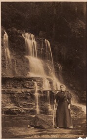 Ballarat Heritage Services
Postcard - Photograph, A Woman at the middle platform of Katoomba Falls
... A Woman at the middle platform of Katoomba Falls...Black and white image of a woman at the middle platform of Katoomba Falls, New SOuth Wales....A Woman at the middle platform of Katoomba Falls Postcard Photograph ...Black and white image of a woman at the middle platform of Katoomba Falls, New SOuth Wales.katoomba falls, waterfall -
 Ringwood and District Historical Society
Photograph, Ringwood Railway Station's main platform and staff in 1914, 1926
... Ringwood Railway Station's main platform and staff in 1914...Showing main building at Ringwood Railway Station in 1914, including railway staff and newspaper shop on the platform....Ringwood and District Historical Society 125A Warrandyte Road Ringwood North melbourne Showing main building at Ringwood Railway Station in 1914, including railway staff and newspaper shop on the platform. Ringwood Railway Station's main platform and staff in 1914 Photograph ...Showing main building at Ringwood Railway Station in 1914, including railway staff and newspaper shop on the platform. -
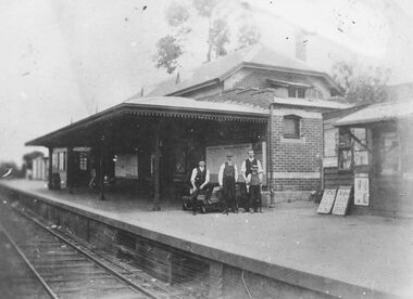
 Ballarat Heritage Services
Photograph, Railway Platform at Carisbrook
... Railway Platform at Carisbrook...Photograph of a woman standing beside railway tracks and six people standing on the platform. Two seem to be folding lamps. ...Ballarat Heritage Services PO Box 2209 Bakery Hill Post Office goldfields Associated with Carisbrook EM22 Carisbrook Carisbrook Railway Station Carisbrook Railway Platform Photograph of a woman standing beside railway tracks and six people standing on the platform. ...Associated with CarisbrookPhotograph of a woman standing beside railway tracks and six people standing on the platform. Two seem to be folding lamps. em22, carisbrook, carisbrook railway station, carisbrook railway platform -
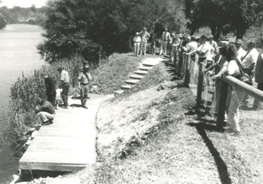 Lakes Entrance Historical Society
Photograph, fishing platform , Tambo River Victoria, 1/11/1994 12:00:00 AM
... fishing platform , Tambo River Victoria...Also three other black and white photographs showing the TAFE students under LEAP program building the fishing platform. ...Also three other black and white photographs showing the TAFE students under LEAP program building the fishing platform. fishing platform , Tambo River Victoria Photograph ...Black and white photograph showing crowd gathered at launch of the fishing platform installed by Tambo Nicholson Management Group and Department of Natural Resources and Environment on the bank of the Tambo River Victoria. Also three other black and white photographs showing the TAFE students under LEAP program building the fishing platform. birds, fishing, jetties -
 Ringwood and District Historical Society
Photograph, Ringwood Railway Station Building ramp to No.2 platform , 1963
... Ringwood Railway Station Building ramp to No.2 platform , 1963...Typed below photograph, "Building ramp to No.2 platform Ringwood Railway Station, 1963". Written on rear of photograph - Old Goods Shed {1889} Still there {in 1963}...Ringwood and District Historical Society 125A Warrandyte Road Ringwood North melbourne Typed below photograph, "Building ramp to No.2 platform Ringwood Railway Station, 1963". Written on rear of photograph - Old Goods Shed {1889} Still there {in 1963} Blackand white photograph Ringwood Railway Station Building ramp to No.2 platform , 1963 Photograph ...Blackand white photographTyped below photograph, "Building ramp to No.2 platform Ringwood Railway Station, 1963". Written on rear of photograph - Old Goods Shed {1889} Still there {in 1963} -
 Greensborough Historical Society
Photograph - Digital image, Jan Lewis, Greensborough Station and platform early 1960s, 1960s
... Greensborough Station and platform early 1960s...Greensborough Station and platform early 1960s...Greensborough Historical Society 34A Glenauburn Road Lower Plenty Lower Plenty melbourne Greensborough Station and platform early 1960s greensborough station Digital copy of black and white photograph Greensborough Station and platform early 1960s Photograph - Digital image Jan Lewis ...Greensborough Station and platform early 1960sDigital copy of black and white photographgreensborough station -
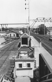
 Melbourne Tram Museum
Document, Yarra Trams, "Opening of Flinders St at Swanston St platform stop", 24-4-2008
... "Opening of Flinders St at Swanston St platform stop"...Document titled "Opening of Flinders St at Swanston St platform stop", notice to employees for 24/4/2008. ...Yields information about the first island platform stop in Melbourne. trams tramways platform stops Flnders St island paltform Document A4 printed sheet. ...Document titled "Opening of Flinders St at Swanston St platform stop", notice to employees for 24/4/2008. New tram stop built as an island platform stop that required trams to open the off-side or opposite doors to that previous. This was the first platform stop in Melbourne. Gives instructions re door controls, and that mirrors had been installed to assist with passenger loading. Signed by Dennis Griffiths, Operations Manager.Yields information about the first island platform stop in Melbourne.Document A4 printed sheet.trams, tramways, platform stops, flnders st, island paltform -
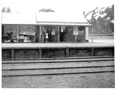 Tarnagulla History Archive
Photograph of people on platform of Tarnagulla Railway Station, People on platform of Tarnagulla Railway Station, circa 1900 to 1940
... People on platform of Tarnagulla Railway Station...Monochrome photograph depicting three men and two children on the platform of the Tarnagulla Railway Station. ...Copy probably made in the 1970s. People on platform of Tarnagulla Railway Station Photograph of people on platform of Tarnagulla Railway Station ...Murray Comrie Collection. Monochrome photograph depicting three men and two children on the platform of the Tarnagulla Railway Station. This is a reasonable copy of an older original. Copy probably made in the 1970s. tarnagulla, railway, rail, transport, trains, station -
Stawell Historical Society Inc
Photograph, Stawell Railway Station showing platform. Photographic Committee National Trust Photographs of Stawell
... Stawell Railway Station showing platform. Photographic Committee National Trust Photographs of Stawell...7006 National Trust Photographs Stawell Railway Station showing platform...Stawell Historical Society Inc 46 Longfield St Stawell grampians 7006 National Trust Photographs Stawell Railway Station showing platform Buildings Heritage Buildings June 1993 Series of Colour Photographs of buildings of interest to National Trust Stawell Railway Station showing platform. ...7006 National Trust Photographs Stawell Railway Station showing platformSeries of Colour Photographs of buildings of interest to National TrustJune 1993buildings, heritage buildings -
![Ephemera - Ticket - Digital Image, VicRail, Train ticket: Watsonia to Show, platform only, adult [no date c1970s], 1970s](/media/collectors/4f729f5697f83e03086015b8/items/663ec3c2c3046c8cdeacab88/item-media/663ec402c3046c8cdeacb0b6/item-fit-380x285.jpg?cb=6) Greensborough Historical Society
Greensborough Historical SocietyEphemera - Ticket - Digital Image, VicRail, Train ticket: Watsonia to Show, platform only, adult [no date c1970s], 1970s
... Train ticket: Watsonia to Show, platform only, adult [no date c1970s]...Digital image of "Watsonia to Show, platform only, adult" [no date c1970s]". This ticket for travel only, admission to Showgrounds paid at gate to Show....Train ticket: Watsonia to Show, platform only, adult [no date c1970s] Ephemera Ticket - Digital Image VicRail ...Digital image of "Watsonia to Show, platform only, adult" [no date c1970s]". This ticket for travel only, admission to Showgrounds paid at gate to Show.Part of a collection of miscellaneous historical images with a connection to the local area.Digital image of train ticket. Cream with black text and red cross.train tickets, watsonia station, royal melbourne show -
 Stawell Historical Society Inc
Photograph, Cato Lake diving platform
... Cato Lake diving platform...Diving Platform Cato Lake also showing Stawell Town Hall Clock in background. ...Cato Lake diving platform Photograph ...Diving Platform Cato Lake also showing Stawell Town Hall Clock in background. The Clock Tower was added to Town Hall in 1939.Photograph of diving tower in Cato Lake. One small photo and an enlarged photo. The Stawell town hall clock can be seen in the background.Diving Tower Cato Lake Stawell.stawell -
 Melbourne Tram Museum
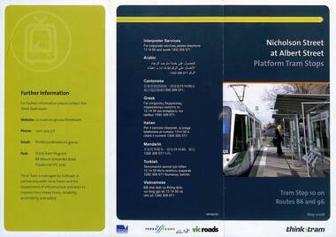
Pamphlet, VicRoads, "Nicholson Street at Albert Street Platform Tram Stops", May 2008
... "Nicholson Street at Albert Street Platform Tram Stops"...Pamphlet - "Nicholson Street at Albert Street Platform Tram Stops" - includes a plan of the proposed work, timing, and benefits of the installation. ...Yields information about the installation of super stops at Nicholson and Albert Sts. trams tramways super stops platform stops planning construction Nicholson St Albert St Pamphlet - 3 fold DL full colour "Nicholson Street at Albert Street Platform Tram Stops" Pamphlet VicRoads ...Pamphlet - "Nicholson Street at Albert Street Platform Tram Stops" - includes a plan of the proposed work, timing, and benefits of the installation. May 2008.Yields information about the installation of super stops at Nicholson and Albert Sts.Pamphlet - 3 fold DL full colourtrams, tramways, super stops, platform stops, planning, construction, nicholson st, albert st -
 Eltham District Historical Society Inc
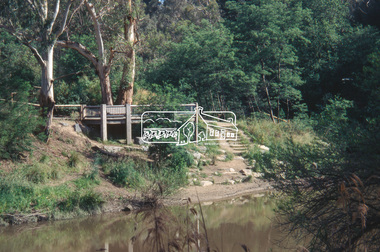
Slide - Photograph, Viewing platform near the confluence of Diamond Creek and Yarra River, c.Nov. 2001
... Viewing platform near the confluence of Diamond Creek and Yarra River...In October 1996 the viewing platform was opened. It is situated near Lenister Farm on the Diamond Creek trail. ...Eltham District Historical Society Inc 728 Main Rd Eltham melbourne In October 1996 the viewing platform was opened. It is situated near Lenister Farm on the Diamond Creek trail. ...In October 1996 the viewing platform was opened. It is situated near Lenister Farm on the Diamond Creek trail. It was a joint project involving Nillumbik Shire Council, Skill Seekers Inc., Department of Natural resources and Environment and Department of Employment, Education, Training and Youth Affairs. The platform was officially opened by Don Cordell Chairman of Commissioners. Part of a slide show presentation "A Trip Down the Diamond Creek" by Russell Yeoman to the Eltham District Historical Society meeting of 14 Nov. 200135mm colour positive transparency Mount - Black and Whiteconfluence, diamond creek, yarra river, viewing platform -
 Eltham District Historical Society Inc
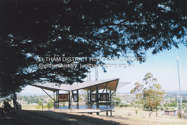
Photograph, Fay Bridge, Moor-rul Viewing Platform, Garden Hill, Kangaroo Ground, n.d
... Moor-rul Viewing Platform, Garden Hill, Kangaroo Ground...OPENING OF THE VIEWING PLATFORM AT KANGAROO GROUND Nillumbik Council has advised that the viewing platform at Kangaroo Ground 27km NE of Melbourne is to be opened to the public on Wednesday, March 26th 2008 (Melway 271 , G10). ...Eltham District Historical Society Inc 728 Main Rd Eltham melbourne OPENING OF THE VIEWING PLATFORM AT KANGAROO GROUND Nillumbik Council has advised that the viewing platform at Kangaroo Ground 27km NE of Melbourne is to be opened to the public on Wednesday, March 26th 2008 (Melway 271 , G10). ...OPENING OF THE VIEWING PLATFORM AT KANGAROO GROUND Nillumbik Council has advised that the viewing platform at Kangaroo Ground 27km NE of Melbourne is to be opened to the public on Wednesday, March 26th 2008 (Melway 271 , G10). The function of the platform is to provide shelter adjacent to the War Memorial Tower whilst allowing all people to enjoy the stunning panoramic views. From the platform you. can see the Dandenongs, the city of Melbourne, the You Yangs, Mount Macedon, the Kinglake Ranges and the Mt Baw-Baw Ranges where the Yarra River starts. This landscape covers all the ancestral lands of the Wurundjeri and some of the wider Kulin nation land. The platform has been given the name Moor-rut, a name which described the fertile soils of the Kangaroo Ground area in contrast to the poorer (Silurian) country of its surrounds, which the Wurundjeri knew as 'Nillumbik' or less rich country. The full 360 degree view can be seen from the adjacent Tower of Remembrance which has 53 stairs. The viewing platform however can be accessed by wheelchair. Inside the viewing platform there are eight double sided interpretive panels giving the history and information regarding this special area. The viewing platform's interpretive panels set out the Aboriginal and European history of the area and also the geology and the local flora and fauna, so that the casual visitor comes away understanding more about this significant part of Victoria. The concept of the viewing platform is part of the refurbishment project for the Kangaroo Ground War Memorial Park which has taken place since 1997 with the active approval and financial assistance of the Nillumbik Shire Council. This project has been guided by an Advisory Committee with volunteer community representatives from the local Historical Societies, the Country Fire Authority, the Returned Services League and the Wurundjeri people. Other allied groups such as the Nillumbik Reconciliation Group have been called upon for their expertise. The initial idea for the viewing platform came from Dean Stewart when he was the caretaker while living at the park. He discussed this idea with local author Mick Woiwod and Harry Gilham of Eltham District Historical Society when they were planning the refurbishment of the War Memorial Park in 1996. When the committee was formalised by the Nillumbik Council in 1997, Nicholas Pelling, representing the CFA and RSL, joined the group. Dennis Ward, local architect, then volunteered to develop the concept plan for the refurbishment of the park and later drew up the plans for the viewing platform. The Kangaroo Ground War Memorial Park and its Tower of Remembrance is located on one of the highest locations in the Yarra Valley. The Tower of Remembrance is a unique war memorial constructed from local stone standing 14 metres high. It was built in the style of a Scottish watchtower reflecting the strong Scottish influence of the first European settlers of the district from the 1840s onward. The park was opened in 1921 and the Tower of Remembrance was dedicated in 1926 recognising the local people who served in the First World War. Those who served in the Second World War were recognised by plaques dedicated in 1951 and more recently those who served in Korea, Borneo, Malaya and Vietnam by plaques unveiled in 2001. Harry Gilham, Advisory Committee Convenor - Eltham District Historical Society Newsletter N0 179 March 2008fay bridge collection, garden hill, kangaroo ground, memorial park, moor-rul viewing platform -
 Eltham District Historical Society Inc
Photograph - Black and White Print, Moor-rul Viewing Platform, March 2007
... Moor-rul Viewing Platform...OPENING OF THE VIEWING PLATFORM AT KANGAROO GROUND Nillumbik Council has advised that the viewing platform at Kangaroo Ground 27km NE of Melbourne is to be opened to the public on Wednesday, March 26th 2008 (Melway 271 , G10). ...OPENING OF THE VIEWING PLATFORM AT KANGAROO GROUND Nillumbik Council has advised that the viewing platform at Kangaroo Ground 27km NE of Melbourne is to be opened to the public on Wednesday, March 26th 2008 (Melway 271 , G10). ...Early stages - no display panels installed. OPENING OF THE VIEWING PLATFORM AT KANGAROO GROUND Nillumbik Council has advised that the viewing platform at Kangaroo Ground 27km NE of Melbourne is to be opened to the public on Wednesday, March 26th 2008 (Melway 271 , G10). The function of the platform is to provide shelter adjacent to the War Memorial Tower whilst allowing all people to enjoy the stunning panoramic views. From the platform you. can see the Dandenongs, the city of Melbourne, the You Yangs, Mount Macedon, the Kinglake Ranges and the Mt Baw-Baw Ranges where the Yarra River starts. This landscape covers all the ancestral lands of the Wurundjeri and some of the wider Kulin nation land. The platform has been given the name Moor-rut, a name which described the fertile soils of the Kangaroo Ground area in contrast to the poorer (Silurian) country of its surrounds, which the Wurundjeri knew as 'Nillumbik' or less rich country. The full 360 degree view can be seen from the adjacent Tower of Remembrance which has 53 stairs. The viewing platform however can be accessed by wheelchair. Inside the viewing platform there are eight double sided interpretive panels giving the history and information regarding this special area. The viewing platform's interpretive panels set out the Aboriginal and European history of the area and also the geology and the local flora and fauna, so that the casual visitor comes away understanding more about this significant part of Victoria. The concept of the viewing platform is part of the refurbishment project for the Kangaroo Ground War Memorial Park which has taken place since 1997 with the active approval and financial assistance of the Nillumbik Shire Council. This project has been guided by an Advisory Committee with volunteer community representatives from the local Historical Societies, the Country Fire Authority, the Returned Services League and the Wurundjeri people. Other allied groups such as the Nillumbik Reconciliation Group have been called upon for their expertise. The initial idea for the viewing platform came from Dean Stewart when he was the caretaker while living at the park. He discussed this idea with local author Mick Woiwod and Harry Gilham of Eltham District Historical Society when they were planning the refurbishment of the War Memorial Park in 1996. When the committee was formalised by the Nillumbik Council in 1997, Nicholas Pelling, representing the CFA and RSL, joined the group. Dennis Ward, local architect, then volunteered to develop the concept plan for the refurbishment of the park and later drew up the plans for the viewing platform. The Kangaroo Ground War Memorial Park and its Tower of Remembrance is located on one of the highest locations in the Yarra Valley. The Tower of Remembrance is a unique war memorial constructed from local stone standing 14 metres high. It was built in the style of a Scottish watchtower reflecting the strong Scottish influence of the first European settlers of the district from the 1840s onward. The park was opened in 1921 and the Tower of Remembrance was dedicated in 1926 recognising the local people who served in the First World War. Those who served in the Second World War were recognised by plaques dedicated in 1951 and more recently those who served in Korea, Borneo, Malaya and Vietnam by plaques unveiled in 2001. Harry Gilham, Advisory Committee Convenor - Eltham District Historical Society Newsletter N0 179 March 2008 Black and white inkjet print on paper 14 x 21 cmmoor-rul viewing platform, garden hill, kangaroo ground, memorial park -
 Whitehorse Historical Society Inc.
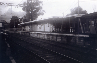
Photograph, Station seen from north side-Platform, 1/06/2009
... Station seen from north side-Platform....This photograph is a close up view of the south platform at Nunawading from the north side.|See NP 3545 to NP3567for the complete set of photographs...This photograph is a close up view of the south platform at Nunawading from the north side.|See NP 3545 to NP3567for the complete set of photographs Station seen from north side-Platform. ...One of a collection of photographs taken of the Nunawading Railway Station prior to the lowering of the railway line and building of the new railway station on the western side of Springvale Road so that the Springvale Road Rail Crossing can be eliminated.Black & white photograph of he precinct surrounding the Nunawading Station and the Springvale Road Railway crossing. This photograph is a close up view of the south platform at Nunawading from the north side.|See NP 3545 to NP3567for the complete set of photographsnunawading railway station, springvale road nunawading, redevelopment of railway line/springvale road.