Showing 70 items matching plenty river trail
-
 Eltham District Historical Society Inc
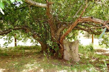
Photograph - Digital Photograph, Alan King, Heritage apple tree, 28 December 2007
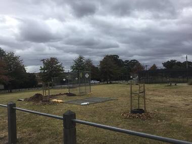
... Plenty River Trail...This old apple tree situated beside the Plenty River Trail... Batman Tree Plenty River Trail Alan King Alan King Marguerite ...This old apple tree situated beside the Plenty River Trail at Greensborough has been associated with Melbourne Founder John Batman. Known as Batman's Tree, this apple tree is on the bank of the Plenty River near Leischa Court, Greensborough. It is said that Melbourne Founder John Batman may have planted the tree and later signed his treaty here with the Aboriginal people. It still bears fruit and its recorded on the National Trust's Register of Significant Trees, as the oldest apple tree in Victoria. Published: Nillumbik Now and Then / Marguerite Marshall 2008; photographs Alan King with Marguerite Marshall.; p7This collection of almost 130 photos about places and people within the Shire of Nillumbik, an urban and rural municipality in Melbourne's north, contributes to an understanding of the history of the Shire. Published in 2008 immediately prior to the Black Saturday bushfires of February 7, 2009, it documents sites that were impacted, and in some cases destroyed by the fires. It includes photographs taken especially for the publication, creating a unique time capsule representing the Shire in the early 21st century. It remains the most recent comprehenesive publication devoted to the Shire's history connecting local residents to the past. nillumbik now and then (marshall-king) collection, greensborough, john batman tree, plenty river trail -
 Greensborough Historical Society
Compact disc, Heritage Victoria Application, 2007_
... plenty river heritage trail... with the proposed Plenty River Heritage Trail.... with the proposed Plenty River Heritage Trail. An example of a grant ...Application for grant from Heritage Victoria including supporting material. Dated 2007. The application deals with the proposed Plenty River Heritage Trail.An example of a grant application.1 compact disk with text files."Heritage Victoria Application"heritage victoria, grant application, noel withers, plenty river, plenty river heritage trail -
 Greensborough Historical Society
Document, Amendment C78 to the Nillumbik Planning Scheme, 03/09/2012
... plenty river trail... whatmough partington plenty river pioneer childrens graves plenty ...The planning scheme amendment is to extend protection to a group of Pioneer Children's graves and an historic apple tree.The graves are from the pioneering Whatmough and Partington families. The apple tree is the surviving remnant of a former orchard on the site and is believed to have been purchased from the estate of John Batman.A 16 page collection of documents sent to GHS Committee member Anne Paul regarding an amendment to the Nillumbik Planning Scheme.Niljohn batman, batman apple tree, whatmough, partington, plenty river, pioneer childrens graves, plenty river trail, nillumbik shire council, greensborough, c78 -
 Greensborough Historical Society
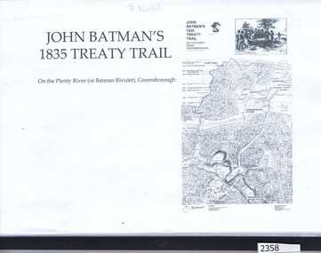
Folder, Dennis Ward, John Batman's 1835 Treaty Trail: on the Plenty River (or Batman's Rivulet), Greensborough / by Dennis Ward, 06/06/1835
... John Batman's 1835 Treaty Trail: on the Plenty River (or...plenty river trail... Trail: on the Plenty River (or Batman's Rivulet), Greensborough ...This information was collected for a grant application to erect signage along the Plenty River path, outlining the history of this area where early settlement of the area occurred. The application was made by GHS member Dennis Ward.Black spiral bound folder with clear cover containing 18 pages of photograph and text.plenty river trail, plenty river, willis vale, dennis ward -
 Greensborough Historical Society
Photograph - Digital Image, Batman Apple Tree 2018, 2018_
... plenty river trail... tree john batman plenty river trail Marilyn Smith ...The Batman apple tree is located on the Plenty Trail north of Greensborough. The tree dates from the mid 1800s and is said to have been purchased from John Batman's estate after his death.Digital copy of colour photographbatman apple tree, john batman, plenty river trail -
 Greensborough Historical Society
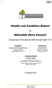
Document - Report, Homewood Consulting Pty Ltd, Assessment of the Batman / Whatmough Apple Tree, 2011, 05/08/2011
... plenty river trail... council plenty river trail Homewood Consulting Pty Ltd ...A health and condition report for Nillumbik Shire Council on the Batman / Whatmough Apple Tree. Prepared by Homewood Consulting in 2011The Batman Apple tree is said to be over 170 years old, being brought to Greensborough in the 1840s from the Melbourne orchard of John Batman, following Batman's death in 1839.9 page photocopy, text and colour illustrations.batman apple tree, robert whatmough, nillumbik council, plenty river trail -
 Greensborough Historical Society
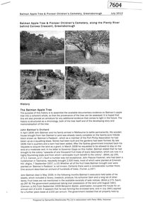
Document - Report, Samantha Westbrooke et al, Batman Apple Tree, & Pioneer Children's Cemetery, Greensborough, 2012, 2012_07
... plenty river trail... whatmough plenty river trail pioneer childrens cemetery Samantha ...A history of the Batman Apple Tree and Pioneer Children's Cemetery along the Plenty River. Prepared by Samantha Westbrooke Pty Ltd in association with Peter Mills, historian. The Batman Apple tree is said to be over 170 years old, being brought to Greensborough in the 1840s from the Melbourne orchard of John Batman, following Batman's death in 1839. The Pioneer Children's Cemetery is the burial place of 7 children from the Whatmough and Partington families who dies between 1845 and 1858.11 page photocopy, text and black and white illustrations.batman apple tree, robert whatmough, plenty river trail, pioneer childrens cemetery -
 Greensborough Historical Society
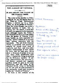
Newspaper - Newspaper Clipping (copy), Evelyn Observer and South East Bourke Record, The Garden of Victoria; in and around the valley of the Diamond Creek, 1890, 28/02/1890
... plenty river trail.... batman apple tree robert whatmough plenty river trail flintoff ...An historical article on the Batman Apple Tree written in 1890. The Batman Apple tree is said to be over 170 years old, being brought to Greensborough in the 1840s from the Melbourne orchard of John Batman, following Batman's death in 1839. 5 page copy of newspaper article, text.Handwritten notes by Anne Paul.batman apple tree, robert whatmough, plenty river trail, flintoff family -
 Greensborough Historical Society
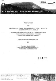
Document - Report, Franz Kreinecker, Tree advice on introduced flora "Batman's Apple Tree", 2002, 2002_07
... plenty river trail..., following Batman's death in 1839. batman apple tree plenty river ...A report on the Batman Apple Tree written in 2002 by Franz Kreinecker, arborist for Nillumbik Shire Council.The Batman Apple tree is said to be over 170 years old, being brought to Greensborough in the 1840s from the Melbourne orchard of John Batman, following Batman's death in 1839. 8 pages of text. No photographs accompany this copy, but a photo list is included in text.batman apple tree, plenty river trail -
 Eltham District Historical Society Inc
Album - Photograph Album, J.A. McDonald, Bridge and Road Reconstruction Works, Shire of Eltham, 1952-1962
... Plenty River Trail... River Trail Plenty River Presbyterian Church Prof Donald Thomson ...J.A. McDonald produced this record in the course of his responsibilities as Shire Engineer for Eltham Shire Council.Record of various Shire of Eltham infrastructure works undertaken during the period of 1952-1962 involving bridge and road reconstruction projects, sometimes with Eltham Shire Council Project Reference numbers quoted. It was during this period that a number of significant improvements were made to roads and new bridges constructed within the shire that remain in place as of present day (2022). In many situations, the photos provide a tangible visible record of infrastructure that existed throughout the early days of the Shire. The album was put together by or under the direction of the Shire Engineer, J.A. McDonald.a. gillies, alistair knox park, benchmark studies, bend of islands, blease road, box hill state school, box hill teachers college, box hill tip, bridge construction, bridge street bridge, bridge, brisbane street, brougham steet, bulldozer, cecil street, charis pelling, cherry tree road, city of preston, cr. a. brinkkotter, cr. charis pelling, cranes, cromwell street, diamond creek (creek), diamond street, dixons creek bridge, dixon's creek road, drott, eltham leisure centre, eltham north, eltham police station, eltham, eltham-yarra glen road, f. wood, fitzsimons lane bridge, flat rock road, flood damage, floods, floodwater, footpaths and gutters, ford service garage, g. blair, garden hill, glen park bridge, glenauburn road, grand hotel, haldane road, healesville, healesville-yarra glen road, heidelberg-kinglake road, henley road bridge, henley road, hill property, hurstbridge water scheme, hurstbridge, hurstbridge-arthurs creek road, infrastructure, j. jolly, kangaroo ground, kangaroo ground-queenstown road, kangaroo ground-st andrews road, lilydale shire office, long gully bridge, long gully creek, long gully road, long gully, lower plenty bridge, lower plenty footbridge, lower plenty oval, lower plenty road, lower plenty, main road, methodist church, montmorency, mount pleasant road, new holland, old healesville road, opening ceremony, oxley bridge, para road, paul creek bridge, paul creek road, paul krafeznk, pinnacle lane, plaques, plenty river trail, plenty river, presbyterian church, prof donald thomson, pryor street, railway crossing, railway parade, rattray road, reconstruction works, reichelt avenue, research (vic.), research oval, road construction, rymers corner, shire of eltham, shire of whittlesea, silvan road bridge, silver street bridge, silver street, sir dallas brooks, smedley property, st andrews, steels creek, susan street, tarrawarra, tony carberry, uniting church, upper yarra dam, upper yarra reservoir, w.e. wolf, waterfall property, watsons creek, wattletree road bridge, wattletree road, wattletree road bridge, worlingworth, yarra glen, york street, yow yow creek -
 Greensborough Historical Society
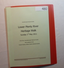
Folder, Lower Plenty River Heritage Walk 2011, 01/05/2011
... Plenty Lower Plenty melbourne Folder Lower Plenty River Heritage ...Contains information about the sites visited on the Heritage Walk 2011 through Yallambie and Viewbank. Notes compiled by Anne Paul with assistance from Russell Yeoman.20-page plastic binder, redcover. Contains 12 page guide.plenty river, heritage trail, anne paul, greensborough historical society, yallambie, viewbank, russell yeoman -
 Greensborough Historical Society
Booklet, Greensborough Historical Society: Heritage Drive 2015, 24/10/2015
... plenty river pioneer trail... plenty river pioneer trail noel withers Noel Withers ...On Saturday 24th October 2015, the Greensborough Historical Society Heritage Day included a walk or drive to the Plenty River heritage precinct, observing many heritage sites in the area. This booklet was prepared by GHS President Noel Withers for those choosing to drive the route. A map is included.16 pages, text and images (some col.).greensborough historical society, plenty river pioneer trail, noel withers -
 Greensborough Historical Society
Booklet, Greensborough Historical Society: Heritage Walk 2015, 24/10/2015
... plenty river pioneer trail... plenty river pioneer trail noel withers Noel Withers ...On Saturday 24th October 2015, the Greensborough Historical Society Heritage Day included a walk or drive to the Plenty River heritage precinct, observing many heritage sites in the area. This booklet was prepared by GHS President Noel Withers for those choosing to walk the route. A map is included.16 pages, text and images.greensborough historical society, plenty river pioneer trail, noel withers -
 Greensborough Historical Society
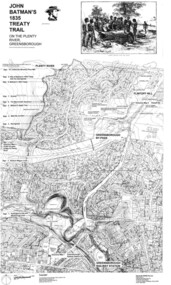
Map, Dennis Ward, John Batman's 1835 Treaty Trail on the Plenty River, 2010_
... John Batman's 1835 Treaty Trail on the Plenty River...plenty river heritage trail... River. plenty river heritage trail Dennis Ward ...Map of the Plenty River through Greensborough and surrounding areas, annotated with historic places. Prepared by Dennis Ward, this map shows places of interest with historic markers for a proposed Heritage Trail along the Plenty. This was a joint project of Dennis Ward, Rotary Greensborough and Nillumbik Historical Society.This map shows many places of interest along the Plenty River. Large laminated map, including land subdivisions and street names.plenty river heritage trail -
 Greensborough Historical Society
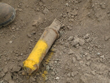
Photograph - Digital image, Dennis Ward, Axle in situ at Partington's Flat, 27/03/2010
... property. It is shown after being uncovered near the Plenty River.... It is shown after being uncovered near the Plenty River trail. From ...This axle is believed to be from one of the vehicles (possibly a jinker) used by the Partington family on the Willis Vale property. It is shown after being uncovered near the Plenty River trail.From a Greensborough pioneer familyDigital copy of colour photograph.partington family, willis vale -
 Eltham District Historical Society Inc
Photograph, Doug Orford, Lower Plenty Bridge, Old Eltham Road, Lower Plenty, 1998
... River Trail.... River Trail. bridges lower plenty main road plenty river Old ...Originally the boundary between the former Shire of Eltham and the City of Heidelberg, a toll gate existed on the Eltham side. The bridge has since been restored and is now part of the Plenty River Trail.Two colour photograph prints 10 x 15 cm (2 copies)bridges, lower plenty, main road, plenty river, old eltham road -
 Greensborough Historical Society
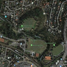
Aerial Photograph - Digital Image, Greensborough central with modern landmarks, 2015_
... and businesses, including Partington's Flat, Whatmough Park, Plenty River... Partington's Flat, Whatmough Park, Plenty River Trail. Bounded ...Aerial photograph of Greensborough showing modern landmarks and businesses, including Partington's Flat, Whatmough Park, Plenty River Trail. Bounded by Diamond Creek Road to the East and the Plenty River to the East, The Circuit to the South. Aerial photograph in colour with overlay text indicating modern landmarksgreensborough, manatunga circuit greensborough, plenty river, diamond creek road greensborough, the circuit greensborough, aerial photograph -
 Greensborough Historical Society
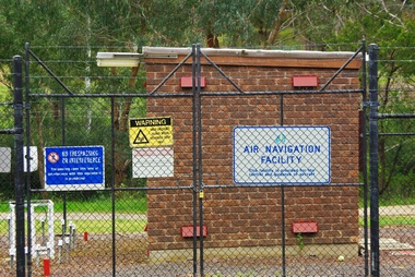
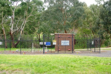
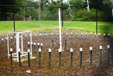
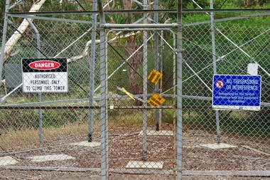
Photograph - Digital Image, Air Navigation Facility, Montmorency, 2018, 1930s
... to the Plenty River Trail. Warning signs are placed on the fences... River Trail. Warning signs are placed on the fences, including ...Air Navigation Facility, Palara Court Montmorency, is made up of a tower and brick building surrounded by wire fences. It is sited in parkland at the end of Palara Court close to the Plenty River Trail. Warning signs are placed on the fences, including: "This facility is provided for the control and guidance of aircraft".Digital copy of colour photographair navigation facility, air control, palara court montmorency -
 Greensborough Historical Society
Photograph - Digital Image, Marilyn Smith, Air Navigation Facility, Montmorency, 2018. Long view, 04/12/2018
... River Trail. Warning signs are placed on the fences, including... close to the Plenty River Trail. Warning signs are placed ...Air Navigation Facility, Palara Court Montmorency, is made up of a tower and brick building surrounded by wire fences. It is sited in parkland at the end of Palara Court close to the Plenty River Trail. Warning signs are placed on the fences, including: "This facility is provided for the control and guidance of aircraft".Digital copy of colour photographsair navigation facility, air control, palara court montmorency -
 Greensborough Historical Society
Photograph - Digital Image, Marilyn Smith, Air Navigation Facility, Montmorency, 2018. Close up, 04/12/2018
... River Trail. Warning signs are placed on the fences, including... close to the Plenty River Trail. Warning signs are placed ...Air Navigation Facility, Palara Court Montmorency, is made up of a tower and brick building surrounded by wire fences. It is sited in parkland at the end of Palara Court close to the Plenty River Trail. Warning signs are placed on the fences, including: "This facility is provided for the control and guidance of aircraft".Digital copy of colour photographair navigation facility, air control, palara court montmorency -
 Greensborough Historical Society
Photograph - Digital Image, Marilyn Smith, Air Navigation Facility, Montmorency, 2018. Signs at tower, 04/12/2018
... River Trail. Warning signs are placed on the fences, including... close to the Plenty River Trail. Warning signs are placed ...Air Navigation Facility, Palara Court Montmorency, is made up of a tower and brick building surrounded by wire fences. It is sited in parkland at the end of Palara Court close to the Plenty River Trail. Warning signs are placed on the fences, including: "This facility is provided for the control and guidance of aircraft". This photograph shows signs at tower.Digital copy of colour photographair navigation facility, air control, palara court montmorency -
 Greensborough Historical Society
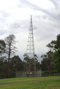
Photograph - Digital Image, Marilyn Smith, Air Navigation Facility, Montmorency, 2018. Tower, 04/12/2018
... River Trail. Warning signs are placed on the fences, including... River Trail. Warning signs are placed on the fences, including ...Air Navigation Facility, Palara Court Montmorency, is made up of a tower and brick building surrounded by wire fences. It is sited in parkland at the end of Palara Court close to the Plenty River Trail. Warning signs are placed on the fences, including: "This facility is provided for the control and guidance of aircraft". This photograph shows the tower on the site.Digital copy of colour photographsair navigation facility, air control, palara court montmorency -
 Greensborough Historical Society
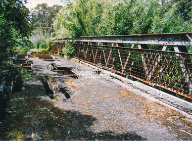
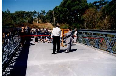
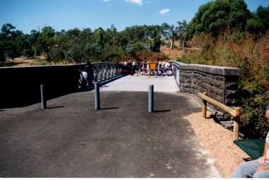
Photograph - Digital Image, Anne Paul, Opening of restored Old Lower Plenty Bridge 2001, 14/03/2001
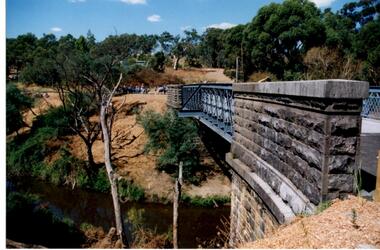
... of Eltham and forms part of the Plenty River Trail.... of Eltham and forms part of the Plenty River Trail. lower plenty ...The opening of the restored Old Lower Plenty Bridge, opened on 14/03/2001 by the Minister for Environment and Conservation Sherryl Garbutt MLA and Mayor of Banyule Cr Dale Peters. The project was jointly funded by Banyule Council and Parks Victoria. The restored bridge is the oldest remaining bridge in the former Shire of Eltham and forms part of the Plenty River Trail.Digital copy of colour photographlower plenty, lower plenty bridge, sherryl garbutt, dale peters, banyule council, parks victoria -
 Greensborough Historical Society
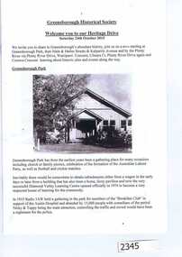
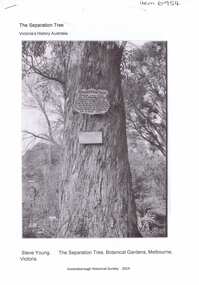
Article, The Separation tree, 2019_
... around Melbourne, including along the Plenty River Trail... River Trail in Greensborough separation tree ...The tree was one of two original red river gums that pre-dated European occupation, and was the site where colonists congregated to celebrate the announcement of Victoria's separation from New South Wales on 15 November 1850. It died as the result of vandalism in 2010 and 2013. Saplings of the original are planted around Melbourne, including along the Plenty River Trail in Greensborough3 p. Wikipedia article; photograph of the tree in the Botanical Gardens, Melbourne (before it was vandalised), and copy of the document of separation of the province of Victoria from the Colony of New South Wales, owned by Colin Boucher..separation tree -
 Greensborough Historical Society
Photograph - Digital Image, Anne Paul, Opening of restored Old Lower Plenty Bridge 2001 - area adjacent, 14/03/2001
... and forms part of the Plenty River Trail. this photograph shows... and forms part of the Plenty River Trail. this photograph shows ...The opening of the restored Old Lower Plenty Bridge, opened on 14/03/2001 by the Minister for Environment and Conservation Sherryl Garbutt MLA and Mayor of Banyule Cr Dale Peters. The project was jointly funded by Banyule Council and Parks Victoria. The restored bridge is the oldest remaining bridge in Nillumbik and forms part of the Plenty River Trail. this photograph shows the area adjacent to the bridge on the day of the opening.Digital copy of colour photographlower plenty, lower plenty bridge, sherryl garbutt, dale peters, banyule council, parks victoria -
 Greensborough Historical Society
Photograph - Digital Image, Anne Paul, Opening of restored Old Lower Plenty Bridge 2001 - side view of bridge, 14/03/2001
... of Eltham and forms part of the Plenty River Trail. This photograph... of the Plenty River Trail. This photograph shows the bridge from ...The opening of the restored Old Lower Plenty Bridge, opened on 14/03/2001 by the Minister for Environment and Conservation Sherryl Garbutt MLA and Mayor of Banyule Cr Dale Peters. The project was jointly funded by Banyule Council and Parks Victoria. The restored bridge is the oldest remaining bridge in the former Shire of Eltham and forms part of the Plenty River Trail. This photograph shows the bridge from the side elevation, showing the bluestone and iron construction.Digital copy of colour photographlower plenty, lower plenty bridge, sherryl garbutt, dale peters, banyule council, parks victoria -
 Greensborough Historical Society
Photograph - Digital Image, Anne Paul, Opening of restored Old Lower Plenty Bridge 2001 - bridge and community, 14/03/2001
... of Eltham and forms part of the Plenty River Trail. This photograph... of the Plenty River Trail. This photograph shows the bridge area ready ...The opening of the restored Old Lower Plenty Bridge, opened on 14/03/2001 by the Minister for Environment and Conservation Sherryl Garbutt MLA and Mayor of Banyule Cr Dale Peters. The project was jointly funded by Banyule Council and Parks Victoria. The restored bridge is the oldest remaining bridge in the former Shire of Eltham and forms part of the Plenty River Trail. This photograph shows the bridge area ready for the opening ceremony and the assembled community members attending the function.Digital copy of colour photographlower plenty, lower plenty bridge, sherryl garbutt, dale peters, banyule council, parks victoria -
 Eltham District Historical Society Inc
Negative - Photograph, J.A. McDonald, Eltham-Yarra Glen Road, Lower Plenty, c. July 1962
... of the Plenty River Trail and Edward Willis Court now follows... a new bridge. The former bridge is now part of the Plenty River ...View looking west across the Eltham-Yarra Glen Road approaching the Lower Plenty Bridge near turn-off for the Golf Club Hotel. Present-day Lower Plenty Road follows a revised alignment across a new bridge. The former bridge is now part of the Plenty River Trail and Edward Willis Court now follows this section of the original Eltham-Yarra Glen Road.. The Golf Club Hotel is gone and a new Lower Plenty Hotel was built slightly further up the hill.Record of various Shire of Eltham infrastructure works undertaken during the period of 1952-1962 involving bridge and road reconstruction projects, sometimes with Eltham Shire Council Project Reference numbers quoted. It was during this period that a number of significant improvements were made to roads and new bridges constructed within the shire that remain in place as of present day (2022). In many situations, the photos provide a tangible visible record of infrastructure that existed throughout the early days of the Shire. The album was put together by or under the direction of the Shire Engineer, J.A. McDonald.1962-07, shire of eltham, old eltham road, edward willis court, eltham-yarra glen road, golf club hotel, infrastructure, lower plenty, road construction -
 Greensborough Historical Society
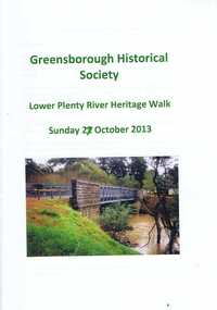
Booklet, Lower Plenty River Heritage Walk Sunday 27 October 2013, 27/10/2013
... of interest along this trail. lower plenty plenty river lower plenty ...This booklet was used during the Heritage Walk along the Lower Plenty River in October 2013. It outlines natural and built landscapes of interest along this trail. 24 pages, illus. (some col.), maps.lower plenty, plenty river, lower plenty river heritage walk -
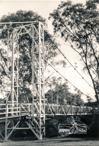 Eltham District Historical Society Inc
Photograph, Pedestrian suspension bridge over the Yarra River at Lower Plenty
Odyssey House drug rehabilitation centre in Bonds Road, Lower Plenty is a distinctive landmark, especially when viewed from across the Yarra at Templestowe. It was built in the 1950’s as a seminary for the Blessed Sacrament Fathers. Because of the poor and circuitous road access, a suspension footbridge was built across the river. As well as providing easy access for the priests residents of Templestowe could attend services at the seminary. The bridge is now part of the Yarra Trails system.Two black and white photographs of footbridge over Yarra River, part of the Ruffey Trail just off the Main Yarra Trail near the former seminary (now Odyssey House) Lower Plentybridges, yarra river, odyssey house, bonds road, lower plenty, seminary, blessed sacrament fathers