Showing 98 items matching "plenty road whittlesea"
-
 Greensborough Historical Society
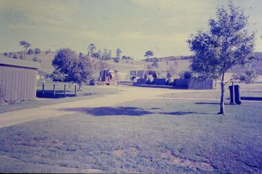
Slide - Photograph, John Ramsdale, Park and kiosk, Whittlesea: Slide 63, 1990s
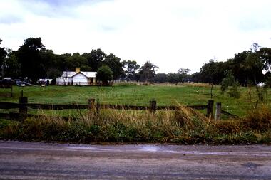
... ...plenty road whittlesea...Photograph shows farm park and kiosk on Plenty Road Whittlesea. This is the future site of Funfields....Funfields plenty road whittlesea No maker's marks. No caption on slide. ...Photograph shows farm park and kiosk on Plenty Road Whittlesea. This is the future site of Funfields.Part of the John Ramsdale collection of slides and audio visual material.Colour photograph scanned from slide.No maker's marks. No caption on slide.funfields, plenty road whittlesea -
 Eltham District Historical Society Inc
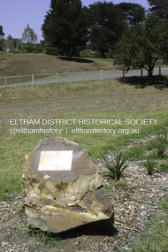
Photograph - Digital Photograph, Alan King, Memorial to Peter Brock, Ferguson's Paddock, Hurstbridge, 23 January 2008
... Road, Doreen, has been particularly active in local affairs. He was President of the Mernda Football Club (then Plenty Rovers), President of the Panton Hill Football League and he founded the Arthurs Creek and District Landcare Group. He also gave more than 50 years of service to the Whittlesea...Road, Doreen, has been particularly active in local affairs. He was President of the Mernda Football Club (then Plenty Rovers), President of the Panton Hill Football League and he founded the Arthurs Creek and District Landcare Group. He also gave more than 50 years of service to the Whittlesea ...Ferguson’s Paddock, Hurstbridge. A plaque on a boulder commemorates Peter Brock. Published: Nillumbik Now and Then / Marguerite Marshall 2008; photographs Alan King with Marguerite Marshall.; p167 On a rock in Ferguson’s Paddock, Hurstbridge, a plaque commemorates Peter Brock. It includes the words: ‘Boy from Hurstbridge without special privileges, grew to become champion of racetracks around the world but he never forgot his beginnings’. Brock came from a well-established local family. Born in Hurstbridge in 1945, he lived in Anzac Avenue as a child, attended the Hurstbridge Primary and Eltham High Schools and lived in the district most of his life. His father Geoff owned the Diamond Valley Speed Shop in Greensborough. Brock’s forbears were amongst the area’s earliest settlers. From Scotland, the Brocks arrived in Tasmania in 1830, to graze sheep. Family members moved to Sunbury, then Preston, grazing sheep in the Bundoora area. John Brock owned Janefield, possibly named after his wife. In 1855 he granted around two acres (0.8ha) of his estate for a school.1 In 1866 Lewis Brock bought 264 acres (107ha) in Nutfield, the first non-Aboriginal person to own that land. They planted an orchard, then from around 1935, Brock’s uncle Sandy and his grandfather Lewis, ran a dairy on the property. In the 1980s Brock and his then partner Bev, bought most of the property, which they sold after their separation in 2006. Brock’s father was a Hurstbridge Football Club President, but Brock’s uncle Sandy, of Brocks Road, Doreen, has been particularly active in local affairs. He was President of the Mernda Football Club (then Plenty Rovers), President of the Panton Hill Football League and he founded the Arthurs Creek and District Landcare Group. He also gave more than 50 years of service to the Whittlesea Agricultural Society, the Volunteers for Australian Football and the Doreen Rural Fire Brigade. Community service was important to Brock too. Brock, with his then partner Bev, established the Peter Brock Foundation in 1997, the year he retired from full-time V8 Supercar racing. The Foundation’s grants have included $100,000 towards the upgrade of a walking track in the Hurstbridge Parklands and other projects include a holiday house for the families of child cancer victims. Brother Lewis saw Brock as a spiritual person, who had a great affinity with people. He saw Brock as a role model of someone who could achieve their dreams. ‘The family didn’t have much money, yet that didn’t stop Peter realising his dreams. He was strong and didn’t let difficult times crush him.’ Despite his later successes, Brock’s most treasured trophy was for running 100 yards (91.4m)at his primary school in 1955, and he appreciated his head master Ted Griffiths’ encouragement of his sporting endeavours. At high school Brock became captain of Everard House. In his first year he bought a 1928 Austin 7 for £5. He cut the car into a box shape with an axe and enjoyed driving it – despite it having no brakes - at his grandparents’ farm at Nutfield. The turning point in Brock’s life came at age 23, when he built an Austin A30 in an old henhouse in Wattle Glen, using a Holden engine. He was laughed at until it won the Australian Sports Sedan Championship in 1968. Brock’s career then took off and he became a professional driver. Brock won Australian motor sport’s best-known event, the Bathurst 1000, nine times. Brock endured a bitter split from Holden in 1986 over control of his Holden-backed vehicle modification business and a car performance-enhancing device he called the ‘energy polariser’– despite it having no scientific evidence to support its claims. But Brock returned to Holden in 1994. Then in 1997, aged 52, Brock retired from fulltime V8 Supercar racing. However he continued to race at motor sport events. Brock won several awards, including an Order of Australia Medal in 1980, the Australian Sports Medal in 2000, and the Centenary Medal. On September 8, 2006, Brock died; after his car hit a tree during the Targa West Rally in Western Australia.This collection of almost 130 photos about places and people within the Shire of Nillumbik, an urban and rural municipality in Melbourne's north, contributes to an understanding of the history of the Shire. Published in 2008 immediately prior to the Black Saturday bushfires of February 7, 2009, it documents sites that were impacted, and in some cases destroyed by the fires. It includes photographs taken especially for the publication, creating a unique time capsule representing the Shire in the early 21st century. It remains the most recent comprehenesive publication devoted to the Shire's history connecting local residents to the past. nillumbik now and then (marshall-king) collection, ferguson's paddock, hurstbridge, peter brock memorial, peter brock -
 Eltham District Historical Society Inc
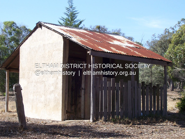
Photograph - Digital Photograph, Marguerite Marshall, Stuchbery Farm dairy, 14 March 2008
... Plenty River bounded by Smugglers Gully to the north and La trobe Road, Yarrambat, to the east. Alan and Ada Stutchbery moved to the valley in 1890, first living in a tent where four children were born. Alfred built a home and outbuildings around 1896. They planted an orchard, then a market garden and developed a dairy. Published: Nillumbik Now and Then / Marguerite Marshall 2008; photographs Alan King with Marguerite Marshall.; p179 The dramatic steep-sided Plenty Gorge lies along the divide of two geological areas, and separates the Nillumbik Shire and the City of Whittlesea. ...Plenty River bounded by Smugglers Gully to the north and La trobe Road, Yarrambat, to the east. Alan and Ada Stutchbery moved to the valley in 1890, first living in a tent where four children were born. Alfred built a home and outbuildings around 1896. They planted an orchard, then a market garden and developed a dairy. Published: Nillumbik Now and Then / Marguerite Marshall 2008; photographs Alan King with Marguerite Marshall.; p179 The dramatic steep-sided Plenty Gorge lies along the divide of two geological areas, and separates the Nillumbik Shire and the City of Whittlesea. ...Stuchbery Farm was situated on the Plenty River bounded by Smugglers Gully to the north and La trobe Road, Yarrambat, to the east. Alan and Ada Stutchbery moved to the valley in 1890, first living in a tent where four children were born. Alfred built a home and outbuildings around 1896. They planted an orchard, then a market garden and developed a dairy. Published: Nillumbik Now and Then / Marguerite Marshall 2008; photographs Alan King with Marguerite Marshall.; p179 The dramatic steep-sided Plenty Gorge lies along the divide of two geological areas, and separates the Nillumbik Shire and the City of Whittlesea. On the Nillumbik side are undulating hills and sedimentary rock, and in Whittlesea, lies a basalt plain formed by volcanic action up to two million years ago. This provides the Plenty Gorge Park with diverse vegetation and habitats, making it one of Greater Melbourne’s most important refuges for threatened and significant species. The park, established in 1986, consists of around 1350 hectares, and extends 11 kilometres along the Plenty River, from Greensborough to Mernda. It provides a wildlife corridor for around 500 native plant and 280 animal species. The area’s plentiful food and water attracted the Wurundjeri Aboriginal people and then European settlers. By 1837 squatters had claimed large runs of land for their sheep and cattle. The Plenty Valley was among the first in the Port Phillip District to be settled - mainly in the less heavily timbered west - and was proclaimed a settled district in 1841. But by the late 1880s, the settlers’ extensive land clearing for animal grazing, then agriculture, depleted the Wurundjeri’s traditional food sources, which helped to drive them away. Many Wurundjeri artefacts remain (now government protected), and so far 57 sites have been identified in the park, including scarred trees, burial areas and stone artefacts. Pioneer life could be very hard because of isolation, flooding, bushfires and bushrangers. Following the Black Thursday bushfires of 1851, basalt was quarried to build more fire-resistant homes. Gold discoveries in the early 1850s swelled the population, particularly around Smugglers Gully; but food production made more of an impact. In the late 1850s wheat production supplanted grazing. In the 1860s the government made small holdings available to poorer settlers. These had the greatest effect on the district, particularly in Doreen and Yarrambat, where orchards were established from the 1880s to 1914. Links with a prominent early family are the remains of Stuchbery Farm, by the river’s edge bounded by Smugglers Gully to the north and La Trobe Road, Yarrambat, to the east. The Stuchberys moved to the valley in 1890, and the family still lives in the area. In 1890, Alfred and Ada first lived in a tent where four children were born, then Alfred built the house and outbuildings around 1896. They planted an orchard, then a market garden, and developed a dairy. The family belonged to the local Methodist and tennis communities. Their grandson Walter, opened the Flying Scotsman Model Railway Museum in Yarrambat, which his widow, Vi, continues to run. Wal was also the Yarrambat CFA Captain for 22 years until 1987. Walter sold 24 hectares in 1976 for development - now Vista Court - and in 1990, the remaining 22.6 hectares for the park. Remaining are an early stone dairy and remnants of a stone barn, a pig sty and a well. Until it was destroyed by fire in 2003, a slab hut stood on the Happy Hollow Farm site, at the southern end of the park. The hut is thought to have been built in the Depression around 1893. This was a rare and late example of a slab hut with a domestic orchard close to Melbourne. Emmet Watmough and his family first occupied the hut, followed by a succession of families, until the Bell family bought it around 1948. There they led a subsistence lifestyle for 50 years, despite encroaching Melbourne suburbia. The Yellow Gum Recreation Area includes the Blue Lake, coloured turquoise at certain times of the year. Following the 1957 bushfires, this area was quarried by Reid Quarries Pty Ltd for Melbourne’s first skyscrapers, then by Boral Australia. However in the early 1970s water began seeping into the quarry forming the Blue Lake and the quarry was closed. The State Government bought the site in 1997 and opened it as a park in 1999.This collection of almost 130 photos about places and people within the Shire of Nillumbik, an urban and rural municipality in Melbourne's north, contributes to an understanding of the history of the Shire. Published in 2008 immediately prior to the Black Saturday bushfires of February 7, 2009, it documents sites that were impacted, and in some cases destroyed by the fires. It includes photographs taken especially for the publication, creating a unique time capsule representing the Shire in the early 21st century. It remains the most recent comprehenesive publication devoted to the Shire's history connecting local residents to the past. nillumbik now and then (marshall-king) collection, ada stuchbery, alan stuchbery, dairy, stuchbery farm, farm buildings, yarrambat, plenty gorge park -
 Greensborough Historical Society
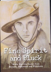
Book, Yarra Plenty Regional Library, Fine spirit and pluck: World War I stories from Banyule, Nillumbik and Whittlesea, 2016_
... Greensborough Historical Society 34A Glenauburn Road Lower Plenty Lower Plenty melbourne A collection of stories of World War One from Banyule, Nillumbik and Whittlesea. ...A collection of stories of World War One from Banyule, Nillumbik and Whittlesea.Collected by Yarra Plenty Regional Library with contributors from the local area.227 p., illus. 2 copiesyarra plenty regional library, world war 1 -
 Greensborough Historical Society
Article, Greensborough Historical Society et al, William Gordon Weir, 1914-1918
... Greensborough Historical Society 34A Glenauburn Road Lower Plenty Lower Plenty melbourne A short article about William Gordon Weir and his service in World War 1. William Weir was born in Whittlesea/Bundoora. world war 1 project william gordon weir 1 page, text and colour images. ...A short article about William Gordon Weir and his service in World War 1. William Weir was born in Whittlesea/Bundoora.1 page, text and colour images.world war 1 project, william gordon weir -
 Greensborough Historical Society
Newspaper Clipping, Diamond Valley Leader, Good place for headspace, 29/07/2016
... Greensborough Historical Society 34A Glenauburn Road Lower Plenty Lower Plenty melbourne Banyule, Nillumbik, Whittlesea and Darebin Councils successfully lobbied the Federal Government to fund the "headspace" facility in Main Street Greensborough. headspace greensborough main street greensborough News clipping, black text and colour image. ...Banyule, Nillumbik, Whittlesea and Darebin Councils successfully lobbied the Federal Government to fund the "headspace" facility in Main Street Greensborough.News clipping, black text and colour image.headspace greensborough, main street greensborough -
 Greensborough Historical Society
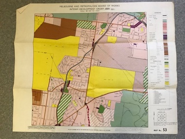
Map, Melbourne and Metropolitan Board of Works Interim Development Order 1961 Map No. 53, 27/09/1961
... Greensborough Historical Society 34A Glenauburn Road Lower Plenty Lower Plenty melbourne Denotes Zones and Reservations comprising part of the municipalities of Eltham, Heidelberg, Preston and Whittlesea, approved 27.9.61. ...Denotes Zones and Reservations comprising part of the municipalities of Eltham, Heidelberg, Preston and Whittlesea, approved 27.9.61. Includes Mont Park Hospital and Watsonia Military Camp.Colour plan Date printed on plan (1959) has been over stamped with 1961. Also stamped with Government Gazette date of 27.9.1961. "Scale 800 feet to 1 inch"greensborough, watsonia -
 Greensborough Historical Society
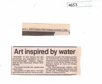
Newspaper Clipping, The Whittlesea Post, Art inspired by water, 07/11/1989
... Greensborough Historical Society 34A Glenauburn Road Lower Plenty Lower Plenty melbourne Notice of an exhibition at the Greensborough Gallery, organised by the Diamond Valley Arts Society and located in the old Greensborough Primary School on Grimshaw Street. diamond valley arts society News article, black text. Art inspired by water Newspaper Clipping The Whittlesea ...Notice of an exhibition at the Greensborough Gallery, organised by the Diamond Valley Arts Society and located in the old Greensborough Primary School on Grimshaw Street.News article, black text.diamond valley arts society -
 Greensborough Historical Society
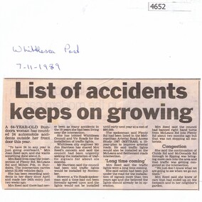
Newspaper Clipping, The Whittlesea Post, List of accidents keeps on growing, 07/11/1989
... Greensborough Historical Society 34A Glenauburn Road Lower Plenty Lower Plenty melbourne Article about the high number of accidents near the intersection of Plenty Road, McLeans Road and Milton Parade Bundoora road accidents plenty road News article, black text. List of accidents keeps on growing Newspaper Clipping The Whittlesea ...Article about the high number of accidents near the intersection of Plenty Road, McLeans Road and Milton Parade BundooraNews article, black text.road accidents, plenty road -
 Greensborough Historical Society
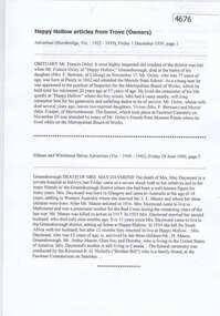
Newspaper clippings, Hurstbridge Advertiser, Happy Hollow articles from Trove (past owners), 1939-1940
... Greensborough Historical Society 34A Glenauburn Road Lower Plenty Lower Plenty melbourne Obituaries of three residents of Happy Hollow, Francis Oxley, John Henry Daymond and May Daymond happy hollow farm francis oxley daymond family 2 p. transcription of newspaper articles Happy Hollow articles from Trove (past owners) Newspaper clippings Hurstbridge Advertiser Eltham and Whittlesea Shires Advertiser Argus ...Obituaries of three residents of Happy Hollow, Francis Oxley, John Henry Daymond and May Daymond2 p. transcription of newspaper articleshappy hollow farm, francis oxley, daymond family -
 Greensborough Historical Society
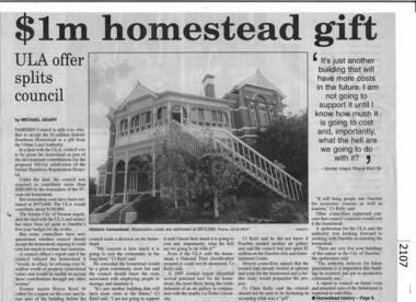
Newspaper - Newspaper Clipping, The Whittlesea Post, Bundoora Homestead to become arts precinct, 1997_
... Greensborough Historical Society 34A Glenauburn Road Lower Plenty Lower Plenty melbourne A collection of articles about Bundoora Homestead and Mount Cooper. bundoora homestead mount cooper Collection of newspaper articles; text and black and white images. Bundoora Homestead to become arts precinct. Newspaper Newspaper Clipping The Whittlesea ...A collection of articles about Bundoora Homestead and Mount Cooper.Collection of newspaper articles; text and black and white images.bundoora homestead, mount cooper -
 Greensborough Historical Society
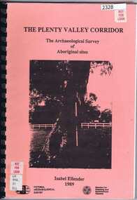
Book, Victoria Archaeological Survey, The Plenty Valley Corridor: the archaeological survey of Aboriginal sites / by Isabel Ellender 1989, 1989_
... Greensborough Historical Society 34A Glenauburn Road Lower Plenty Lower Plenty melbourne This archaeological survey of th Plenty Valley was conducted by Isabel Ellender in 1989 for the Ministry of Planning and Environment. The area studied is north of Greensborough to Whittlesea ...This archaeological survey of th Plenty Valley was conducted by Isabel Ellender in 1989 for the Ministry of Planning and Environment. The area studied is north of Greensborough to Whittlesea. A number of Aboriginal sites were identified and recommendations made for the future.103 p., illus., maps. Plastic spiral binding.plenty river, aboriginal heritage sites -
 Greensborough Historical Society
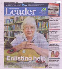
Newspaper clipping, Diamond Valley Leader, Enlisting help: stories honour Anzacs; with Yarra Plenty Regional Library flyer advertising Discover your Anzac story program, 26/11/2014
... Road Lower Plenty Lower Plenty melbourne Research by Maureen Jones about Sgt. Reginald Simms and Nurse Elizabeth Gallagher as part of Yarra Plenty Regional Library publication program about people from Nillumbik, Banyule and Whittlesea who served in World War 1. ...Research by Maureen Jones about Sgt. Reginald Simms and Nurse Elizabeth Gallagher as part of Yarra Plenty Regional Library publication program about people from Nillumbik, Banyule and Whittlesea who served in World War 1. Includes Yarra Plenty Regional Library flyer about the project.Front page colour image and article and image p. 5. Small colour flyer.world war 1, maureen jones, yarra plenty regional library, reginald simms, elizabeth gallagher -
![Award - Trophy, Thomastown Golf Club, [Thomastown Golf Club] Whittlesea 23/04/1978. C Grade, Bob Jones, 1978](/media/collectors/4f729f5697f83e03086015b8/items/64a8f02e7867ee37a141ffdf/item-media/64a8f05b7867ee37a1420454/item-fit-380x285.jpg?cb=6) Greensborough Historical Society
Greensborough Historical SocietyAward - Trophy, Thomastown Golf Club, [Thomastown Golf Club] Whittlesea 23/04/1978. C Grade, Bob Jones, 1978
... Road Lower Plenty Lower Plenty melbourne Golf trophy awarded by the Thomastown Golf Club. Bob Jones was a foundation member of the Club and Secretary for many years. Thomastown Golf Club was a social golf club formed in 1976. This is part of the Robert (Bob) Jones collection of Club memorabilia. Thomastown Golf Club golf trophies Bob Jones Robert Jones "Thomastown Golf Club. Best Clubman 1992. Robert Jones." engraved on plaque. Golf trophy, plastic golfer on plastic stand with stone base. [Thomastown Golf Club] Whittlesea ...Golf trophy awarded by the Thomastown Golf Club. Bob Jones was a foundation member of the Club and Secretary for many years.Thomastown Golf Club was a social golf club formed in 1976. This is part of the Robert (Bob) Jones collection of Club memorabilia.Golf trophy, plastic golfer on plastic stand with stone base."Thomastown Golf Club. Best Clubman 1992. Robert Jones." engraved on plaque.thomastown golf club, golf trophies, bob jones, robert jones -
 Greensborough Historical Society
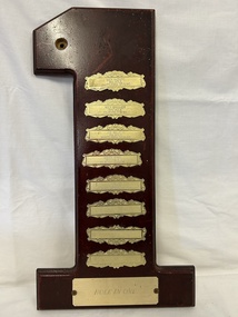
Award - Trophy, Thomastown Golf Club, Thomastown Golf Club. Hole in One, 1980-1987
... Greensborough Historical Society 34A Glenauburn Road Lower Plenty Lower Plenty melbourne Golf trophy awarded by the Thomastown Golf Club to members who hit a "hole in one". Winners include: Nick Kaziro, 8th hole Whittlesea 27/01/1980; Mick Brasher, 16th hole Kilmore 07/09/1980; Joe Maletic, 8th hole Whittlesea 26/06/1983; Bruce Ryan, 16th hole Kilmore 26/02/1984; Sam Sia, 13th hole Bacchus Marsh 14/06/1987. ...Golf trophy awarded by the Thomastown Golf Club to members who hit a "hole in one". Winners include: Nick Kaziro, 8th hole Whittlesea 27/01/1980; Mick Brasher, 16th hole Kilmore 07/09/1980; Joe Maletic, 8th hole Whittlesea 26/06/1983; Bruce Ryan, 16th hole Kilmore 26/02/1984; Sam Sia, 13th hole Bacchus Marsh 14/06/1987.Thomastown Golf Club was a social club formed in 1976. This is part of the Robert (Bob) Jones collection of Club memorabilia.Golf trophy in the shape of a timber number one with metal plaques."Thomastown Golf Club. C Grade Hole in One" engraved on plaque, winners' names on small plaques.thomastown golf club, golf trophies, bob jones, hole in one -
 Greensborough Historical Society
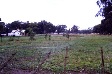
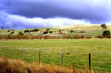
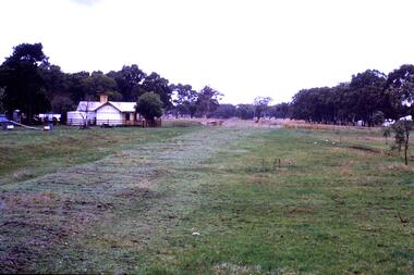
Slide - Photograph, John Ramsdale, Rail line near Whittlesea: Slide 120, 1990s
... Greensborough Historical Society 34A Glenauburn Road Lower Plenty Lower Plenty melbourne Photograph shows what appears to be a rural farmhouse and paddock, this is part of the site of the old railway line to Whittlesea. ...Photograph shows what appears to be a rural farmhouse and paddock, this is part of the site of the old railway line to Whittlesea. In centre of photo is the old station platform.Part of the John Ramsdale collection of slides and audio visual material.Colour photograph scanned from slide.No maker's marks. No caption on slide.whittlesea, whittlesea rail line -
 Greensborough Historical Society
Photograph - Newspaper Clipping - Digital Image, The Whittlesea Post, Bundoora Square 1985, 20/11/1985
... Road Lower Plenty Lower Plenty melbourne Bundoora Square is the shopping centre on the corner of Plenty Road and Settlement Road Bundoora. This full page advertisement was published for Christmas at Bundoora Square in 1985. bundoora square bundoora shopping centre plenty road bundoora Digital copy of newspaper advertisement Bundoora Square 1985 Photograph Newspaper Clipping - Digital Image The Whittlesea Post ...Bundoora Square is the shopping centre on the corner of Plenty Road and Settlement Road Bundoora. This full page advertisement was published for Christmas at Bundoora Square in 1985.Digital copy of newspaper advertisementbundoora square, bundoora shopping centre, plenty road bundoora -
 Greensborough Historical Society
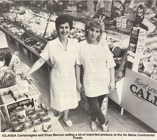
Photograph - Newspaper Clipping - Digital Image, The Whittlesea Post, Bundoora Square, De Maria Continental Foods1988, 13/12/1988
... Road Lower Plenty Lower Plenty melbourne Bundoora Square is the shopping centre on the corner of Plenty Road and Settlement Road Bundoora. The newspaper clipping shows staff, Iolanda and Enza, at De Maria Continental Foods in 1988. bundoora square bundoora shopping centre plenty road bundoora De Maria Continental Foods Digital copy of newspaper article Bundoora Square, De Maria Continental Foods1988 Photograph Newspaper Clipping - Digital Image The Whittlesea Post ...Bundoora Square is the shopping centre on the corner of Plenty Road and Settlement Road Bundoora. The newspaper clipping shows staff, Iolanda and Enza, at De Maria Continental Foods in 1988.Digital copy of newspaper articlebundoora square, bundoora shopping centre, plenty road bundoora, de maria continental foods -
 Greensborough Historical Society
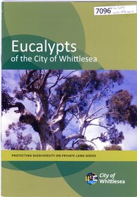
Booklet, City of Whittlesea, Eucalypts of the City of Whittlesea, 2015c
... Greensborough Historical Society 34A Glenauburn Road Lower Plenty Lower Plenty melbourne eucalypts native flora whittlesea 30 p. booklet, stapled, colour illustrations Eucalypts of the City of Whittlesea Booklet City of Whittlesea ...30 p. booklet, stapled, colour illustrationseucalypts, native flora, whittlesea -
 Greensborough Historical Society
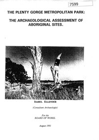
Book, Isabel Ellender, The Plenty Valley Corridor: the archaeological survey of Aboriginal sites / by Isabel Ellender 1991, 1991_
... Greensborough Historical Society 34A Glenauburn Road Lower Plenty Lower Plenty melbourne This archaeological survey of the Plenty Valley was conducted by Isabel Ellender in 1991 for the Board of Works (Melbourne Water), in particular the Plenty Gorge Metropolitan Park. The area studied is north of Greensborough to Whittlesea ...This archaeological survey of the Plenty Valley was conducted by Isabel Ellender in 1991 for the Board of Works (Melbourne Water), in particular the Plenty Gorge Metropolitan Park. The area studied is north of Greensborough to Whittlesea. A number of Aboriginal sites were identified and recommendations made for the future.67 p., illus., maps. Plastic spiral binding.plenty river, aboriginal heritage sites, plenty gorge metropolitan park -
 Greensborough Historical Society
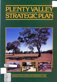
Booklet - Leaflet, Plenty Valley strategic plan, August 1989
... Greensborough Historical Society 34A Glenauburn Road Lower Plenty Lower Plenty melbourne A 1989 planning document for the Plenty Valley growth area, as much of it moved from rural to residential zoning. plenty valley urban development plenty river shire of diamond valley whittlesea 8 p., text and col. illustrations Plenty Valley strategic plan Booklet Leaflet Ministry for Planning and Environment, Victoria ...A 1989 planning document for the Plenty Valley growth area, as much of it moved from rural to residential zoning.8 p., text and col. illustrationsplenty valley, urban development, plenty river, shire of diamond valley, whittlesea -
 Greensborough Historical Society
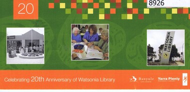
Flyer - Invitation, Yarra Plenty Regional Library, Celebrating 20th anniversary of Watsonia Library, 08/11/2008
... Greensborough Historical Society 34A Glenauburn Road Lower Plenty Lower Plenty melbourne Watsonia Library is part of Yarra Plenty Rergional Library, operating over Banyule, Nillumbik and Whittlesea Local Government areas yarra plenty regional library watsonia library Addressed to Rosie Bray in handwriting Cardboard invitation, printed in colour both sides Celebrating 20th anniversary of Watsonia Library Flyer Invitation Yarra Plenty Regional Library ...Watsonia Library is part of Yarra Plenty Rergional Library, operating over Banyule, Nillumbik and Whittlesea Local Government areasCardboard invitation, printed in colour both sidesAddressed to Rosie Bray in handwritingyarra plenty regional library, watsonia library -
 Greensborough Historical Society
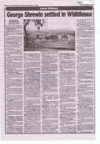
Newspaper - Newspaper Clipping, The Local Paper, George Shrewin settled in Whittlesea, 17/02/2021
... Greensborough Historical Society 34A Glenauburn Road Lower Plenty Lower Plenty melbourne Article on the early white settlement of the Whittlesea area, taken from "The Plenty" by J.W.Payne (published 1975). ...Article on the early white settlement of the Whittlesea area, taken from "The Plenty" by J.W.Payne (published 1975). Part 1 only.One page, new article. Text and black and white image.whittlesea, j.w.payne, the plenty -
 Greensborough Historical Society
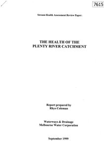
Document - Report, Rhys Coleman, The Health of the Plenty River Catchment 1999, 1999_09
... Greensborough Historical Society 34A Glenauburn Road Lower Plenty Lower Plenty melbourne Report prepared by Rhys Coleman for Waterways and Drainage, Melbourne Water Corporation, discusses the health of the Plenty River catchment from upstream of Toorourrong Reservoir, through Whittlesea and Mernda, South Morang and Plenty to Greensborough and confluence with the Yarra River. plenty river melbourne water corporation 31 p., tables. ...Report prepared by Rhys Coleman for Waterways and Drainage, Melbourne Water Corporation, discusses the health of the Plenty River catchment from upstream of Toorourrong Reservoir, through Whittlesea and Mernda, South Morang and Plenty to Greensborough and confluence with the Yarra River.31 p., tables.plenty river, melbourne water corporation -
 Greensborough Historical Society
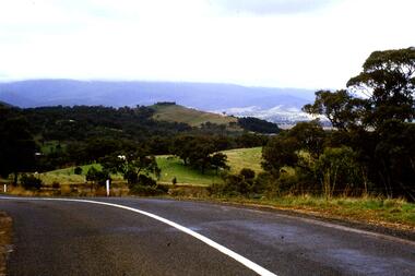
Slide - Photograph, John Ramsdale, Whittlesea to Wallan Road: Slide 89, 1990s
... Greensborough Historical Society 34A Glenauburn Road Lower Plenty Lower Plenty melbourne Photograph shows road and rural scene. this is the Whittlesea to Wallan Road north of Whittlesea. ...Photograph shows road and rural scene. this is the Whittlesea to Wallan Road north of Whittlesea.Part of the John Ramsdale collection of slides and audio visual material.Colour photograph scanned from slide.No maker's marks. No caption on slide.whittlesea, wallan, whittlesea to wallan road -
 Greensborough Historical Society
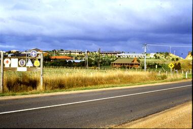
Slide - Photograph, John Ramsdale, Residential development south of Whittlesea: Slide 92, 1990s
... Greensborough Historical Society 34A Glenauburn Road Lower Plenty Lower Plenty melbourne Photograph shows residential development south of Whittlesea encroaching on farmland. ...Photograph shows residential development south of Whittlesea encroaching on farmland.Part of the John Ramsdale collection of slides and audio visual material.Colour photograph scanned from slide.No maker's marks. No caption on slide.whittlesea, residential development -
 Greensborough Historical Society
Slide - Photograph, John Ramsdale, Rail line near Whittlesea: Slide 94, 1990s
... Greensborough Historical Society 34A Glenauburn Road Lower Plenty Lower Plenty melbourne Photograph shows what appears to be a rural farmhouse and paddock, this is part of the site of the old railway line to Whittlesea. ...Photograph shows what appears to be a rural farmhouse and paddock, this is part of the site of the old railway line to Whittlesea. In centre of photo is the old station platform.Part of the John Ramsdale collection of slides and audio visual material.Colour photograph scanned from slide.No maker's marks. No caption on slide.whittlesea, whittlesea rail line -
 Greensborough Historical Society
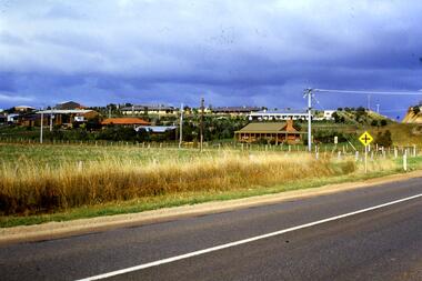
Slide - Photograph, John Ramsdale, Coming into Whittlesea: Slide 96, 2060
... Greensborough Historical Society 34A Glenauburn Road Lower Plenty Lower Plenty melbourne Photograph shows houses in Whittlesea. ...Photograph shows houses in Whittlesea.Part of the John Ramsdale collection of slides and audio visual material.Colour photograph scanned from slide.No maker's marks. No caption on slide.whittlesea -
 Greensborough Historical Society
Slide - Photograph, John Ramsdale, Coming into Whittlesea: Slide 98, 1990s
... Greensborough Historical Society 34A Glenauburn Road Lower Plenty Lower Plenty melbourne Photograph shows houses in Whittlesea Part of the John Ramsdale collection of slides and audio visual material. whittlesea No maker's marks. ...Photograph shows houses in WhittleseaPart of the John Ramsdale collection of slides and audio visual material.Colour photograph scanned from slide.No maker's marks. No caption on slide.whittlesea -
 Greensborough Historical Society
Slide - Photograph, John Ramsdale, Old Whittlesea rail line: Slide 107, 1990s
... Greensborough Historical Society 34A Glenauburn Road Lower Plenty Lower Plenty melbourne Photograph shows what appears to be a rural farmhouse and paddock, this is part of the site of the old railway line to Whittlesea. ...Photograph shows what appears to be a rural farmhouse and paddock, this is part of the site of the old railway line to Whittlesea. In centre of photo is the old station platform.Part of the John Ramsdale collection of slides and audio visual material.Colour photograph scanned from slide.No maker's marks. No caption on slide.whittlesea, whittlesea rail line