Showing 528 items matching "plotting"
-
 University of Melbourne, Burnley Campus Archives
Slide - Glass slide, 1891-1905
... Lorquon School Vegetable plots...Lorquon School Vegetable plots.'...Lorquon School Vegetable plots....Lorquon School Vegetable plots. '18. Lorquon School Vegetable plots.' ...Lorquon School Vegetable plots '18. Lorquon School Vegetable plots.'18. Lorquon School Vegetable plots.school gardens, australia, lorquon, vegetables -
 Creswick Campus Historical Collection - University of Melbourne
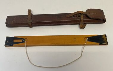
Instrument - Plotting Rule with Pouch, W.H. Harling Plotting Rule With Pouch
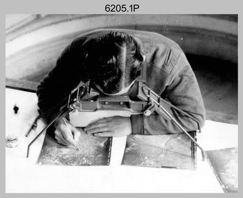
... W.H. Harling Plotting Rule With Pouch...Plotting Rule, W.H. Harling, single-sided, wood with brass sighting pieces at each end. ...Map reading scales are marked on each bevelled edge of the rule W.H. Harling Plotting Rule With Pouch Instrument Plotting Rule with Pouch ...Research and TrainingPlotting Rule, W.H. Harling, single-sided, wood with brass sighting pieces at each end. In leather pouch, wood / metal / leather, WH Harling, London, 1919. The end pieces that lift to 90 degrees and act as sighting elements are bolted by four bolts each. Map reading scales are marked on each bevelled edge of the ruleW.H. Harling, London, 1919, No. 8047. Leather Pouch : JAS DAWSON & SONL 1918. 002 -
Tatura Irrigation & Wartime Camps Museum
Book, Plotting Hitler's Death, 1994
... Plotting Hitler's Death...Tatura Irrigation & Wartime Camps Museum 49 Hogan Street Tatura the-murray Donated by ex Jewish Dunera Boy. joseph c grew us ambassador japanese ambassadores war with japan Red soft cover with a picture of Hitler and white writing on the front,Red and black writing on the spine and on the back. Plotting Hitler's Death Book ...Donated by ex Jewish Dunera Boy.Red soft cover with a picture of Hitler and white writing on the front,Red and black writing on the spine and on the back.joseph c grew, us ambassador, japanese ambassadores, war with japan -
Moorabbin Air Museum
Booklet - Air Navigation, Air Navigation Plotting
... Air Navigation Plotting...Moorabbin Air Museum Moorabbin Airport 12 First Street Moorabbin melbourne Air Navigation Hanbook on air navigation plotting for prospective pilots & observers, circa 1943 Air Navigation Plotting Booklet Air Navigation ...Hanbook on air navigation plotting for prospective pilots & observers, circa 1943non-fictionHanbook on air navigation plotting for prospective pilots & observers, circa 1943 -
 Moorabbin Air Museum
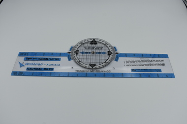
Equipment (item), apr Rotary Azimuth Plotter NPR-13 Wilsonair Australia
... apr Rotary Azimuth Plotter NPR-13 Wilsonair Australia...apr IPR-13 ICAO Plotter...Moorabbin Air Museum Moorabbin Airport 12 First Street Moorabbin melbourne apr IPR-13 ICAO Plotter apr Rotary Azimuth Plotter NPR-13 Wilsonair Australia apr Rotary Azimuth Plotter NPR-13 Wilsonair Australia Equipment ...apr IPR-13 ICAO Plotter -
 Ararat & District Historical Society (operating the Langi Morgala Museum)
Photograph
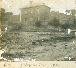
... A series of three black and white photographs of the Citizens Plot at Alexandra Gardens. 501 shows the bluestone building J Ward standing behind a wooden picket fence with bare earth in front. 502 shows men in suits standing with three horses attached to two wagons with large trees in the background. 503 shows plants that have grown in the Citizens Plot garden....501: Citizens Plot 1908 502: Citizens Plot 1909. 503: Citizens Plot showing growth 1921....Ararat & District Historical Society (operating the Langi Morgala Museum) 48 Queen Street Ararat grampians Record of local history 501: Citizens Plot 1908 502: Citizens Plot 1909. 503: Citizens Plot showing growth 1921. ...Record of local historyA series of three black and white photographs of the Citizens Plot at Alexandra Gardens. 501 shows the bluestone building J Ward standing behind a wooden picket fence with bare earth in front. 502 shows men in suits standing with three horses attached to two wagons with large trees in the background. 503 shows plants that have grown in the Citizens Plot garden.501: Citizens Plot 1908 502: Citizens Plot 1909. 503: Citizens Plot showing growth 1921. -
 University of Melbourne, Burnley Campus Archives
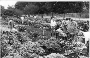
Photograph - Colour print, James (Jim) Pleasance, Plot Preparation, 1983-1996
... Plot Preparation...Students working in the vegetable plots in the Orchard....On reverse, "Plot Preparation J. Pleasance V.C.A.H. Burnley Garden. ...Students working in the vegetable plots in the Orchard. Plot Preparation Photograph Colour print James (Jim) Pleasance ...Used as an illustration in, "Green Grows Our Garden," A.P. Winzenried p 152.Colour photograph. Students working in the vegetable plots in the Orchard.On reverse, "Plot Preparation J. Pleasance V.C.A.H. Burnley Garden. Swan St Richmond."vegetable garden, vcah, green grows our garden, a.p. winzenried, students working outside, orchard, vegetable plots -
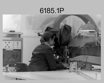
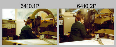
 Bendigo Military Museum
Photograph - Photogrammetric Equipment – Army Survey Regiment, Bendigo and School of Military Survey Bonegilla, c1960s to c1980s
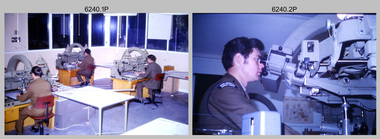
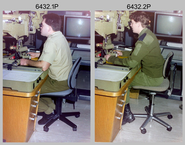
... The Wild B9 and B8 stereo plotters were used for plotting topographic detail and contours. ...Photogrammetric Equipment – Army Survey Regiment, Fortuna, Bendigo c.1981. . .7) – Unidentified technician operating Wild B8 stereo plotter in AUTOMAP 1 at ASR. .8) - Wild B8 stereo plotter in AUTOMAP 1 at ASR. ...The Wild B9 and B8 stereo plotters were used for plotting topographic detail and contours. ...This is a set of 14 photographs of RA Svy technicians operating photogrammetric equipment in Air Survey Squadron, Army Survey Regiment, Fortuna, Bendigo; and the School of Military Survey Bonegilla c1960s to c1980s. The Wild B9 stereo plotter were introduced in 1962 and the Wild B8 stereo plotter was introduced in 1966. The Wild B9 and B8 stereo plotters were used for plotting topographic detail and contours. These analogue machines were manually controlled by adjusting the control knobs for the orientation of the 3D image. The B9s used a four and a half square, and the B8s used a nine-inch square photo image on a film or glass diapositive which allowed highly accurate extraction of map features. At first, plotting with B8 and B9 stereo plotters was undertaken at the aerial photography scale of 1:80,000 in pencil onto a controlled plotting sheet. Sheets were then inked up and reduced photographically to the 1: 100,000 publication scale for scribe impression production. In the early days topographic detail and contours were plotted with a pencil or ink pen mounted at the far end of the pantograph arm. The plotting procedure was upgraded to direct plotting in ink with photographic reduction to publication scale. In 1975 four B8s were upgraded with tri-axis locaters as part of the Input Sub-system to enable digital extraction to AUTOMAP 1’s topographic database. When AUTOMAP 2 was introduced in 1982 these B8s were upgraded, and additional machines added to expand the Army Survey Regiment’s digital capture capability. There are several more photos catalogued in the Victorian Collections database of RA Svy personnel operating Wild B9 and B8 stereo plotters.Photogrammetric Equipment – Army Survey Regiment, Fortuna, Bendigo c.1981. . .7) – Unidentified technician operating Wild B8 stereo plotter in AUTOMAP 1 at ASR. .8) - Wild B8 stereo plotter in AUTOMAP 1 at ASR. Photogrammetric Equipment – Army Survey Regiment, Fortuna, Bendigo. c1981. .9) – ASR’s CPL Dave Cook in AUTOMAP 1 operating a Wild B8 stereo plotter. This is a set of 14 photographs of RA Svy technicians operating photogrammetric equipment at the Army Survey Regiment (ASR), Bendigo and the School of Military Survey (SMS) Bonegilla. c1960s to c1980s. The photographs are on 35mm colour slides and were scanned at 96 dpi. .1) - Photo, colour, c1964. Unidentified ASR technicians operating analogue Wild B9 stereo plotters. .2) - Photo, colour, c1974. ASR’s SPR Mick Minchin operating an analogue Wild B8 stereo plotter. .3) to .6) - Photo, colour, c1980. Photogrammetry Instructor SGT Neil ‘Ned’ Kelly at the SMS operating an analogue Wild B8 stereo plotter. .7) - Photo, colour, c1981. Unidentified technician operating Wild B8 stereo plotter in AUTOMAP 1 at ASR. .8) - Photo, colour, c1981. Wild B8 stereo plotter in AUTOMAP 1 at ASR. .9) to .14) - Photo, colour, c1981. ASR’s CPL Dave Cook in AUTOMAP 1 operating a Wild B8 stereo plotter..1P to .14P - Some of the equipment is annotated on the frame of the 35mm slides.royal australian survey corps, rasvy, army survey regiment, army svy regt, fortuna, asr, photogrammetry -
 Bendigo Military Museum
Photograph - Photogrammetric Equipment – Army Survey Regiment, Fortuna, Bendigo, c1960s to c1980s
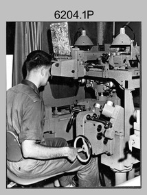
... The Wild A9 Stereocomparator and Wild B9 stereo plotter were introduced in 1962. The Wild B8 stereo plotter was introduced in 1966. ...Unidentified technician in AUTOMAP 2 operating a Wild B8 stereo plotter....The Wild A9 Stereocomparator and Wild B9 stereo plotter were introduced in 1962. The Wild B8 stereo plotter was introduced in 1966. ...This is a set of eight photographs of technicians operating photogrammetric equipment in Air Survey Squadron, Army Survey Regiment, Fortuna, Bendigo. c1960s to c1980s. The Wild A9 Stereocomparator and Wild B9 stereo plotter were introduced in 1962. The Wild B8 stereo plotter was introduced in 1966. Technicians used the Wild A9 Stereocomparator to accurately measure between pass, tie, and survey control points on aerial photographs. The Wild B9 and B8s were used for plotting topographic detail and contours. These analogue machines were manually controlled by adjusting the control knobs for the orientation of the 3D image. The B9s used a four and a half square, and the B8s used a nine-inch square photo image on a film or glass diapositive which allowed highly accurate extraction of map features. At first, plotting with B8 and B9 stereo plotters was undertaken at the aerial photography scale of 1:80,000 in pencil onto a controlled plotting sheet. Sheets were then inked up and reduced photographically to the 1: 100,000 publication scale for scribe impression production. In the early days topographic detail and contours were plotted with a pencil or ink pen mounted at the far end of the pantograph arm. The plotting procedure was upgraded to direct plotting in ink with photographic reduction to publication scale. In 1975 four B8s were upgraded with tri-axis locaters as part of the Input Sub-system to enable digital extraction to AUTOMAP 1’s topographic database. When AUTOMAP 2 was introduced in 1982 these B8s were upgraded, and additional machines added to expand the Army Survey Regiment’s digital capture capability. This is a set of eight photographs of technicians operating photogrammetric equipment in Air Survey Squadron, Army Survey Regiment, Fortuna, Bendigo. c1960s to c1980s. Black and white and colour photos are on photographic paper and scanned at 300 dpi. .1) - Photo, black & white, c1965. Unidentified technician operating a Wild A9 Stereocomparator. .2) - Photo, black & white, c1965. Unidentified technician operating a Wild B9 stereo plotter. .3) - Photo, black & white, c1967. L to R: Unidentified technician, SPR Ken Jeffery operating a Wild B9 stereo plotter. .4) - Photo, colour, c1974. Unidentified technician, operating a Wild B8 stereo plotter. .5) - Photo, black & white, c1974. Unidentified technician operating a Wild B8 stereo plotter. .6) to .7) - Photo, black & white, c1979. Unidentified technicians operating a Wild B8 stereo plotter. .8) - Photo, black & white, c1985. Unidentified technician in AUTOMAP 2 operating a Wild B8 stereo plotter..1P, .2P, .4P, .5P, .7P – no annotations. .3P – annotated ‘Standing - , Seated SPR Ken Jefferies (sic). .6P – annotated with date ‘1979’ .8P – annotated ‘AUTOMAP 2’royal australian survey corps, rasvy, army survey regiment, army svy regt, fortuna, asr, air survey, photogrammetry -
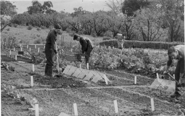
 University of Melbourne, Burnley Campus Archives
Photograph - Black and white print, Publicity Branch, Department of Agriculture, Victoria, Students Working in the Vegetable Plots, c. 1962
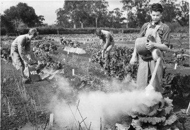
... The location of the photo is the student individual plot ground."...Students dusting, watering and digging in their vegetable plots....Students dusting, watering and digging in their vegetable plots. Students Working in the Vegetable Plots Photograph Black and white print Publicity Branch, Department of Agriculture, Victoria ...Note by T.H. Kneen 18 December 1991 "Students L-R: Lex Hodge (1962),Oliver Frost (1962), Peter Trudgeon (1963). The location of the photo is the student individual plot ground."2 copies black and white photograph. Students dusting, watering and digging in their vegetable plots.On reverse stamp, "Photograph by Publicity Branch Victorian Department Of Agriculture Ref. No. c.1695N."watering, digging, lex hodge, oliver frost, peter trudgeon, department of agriculture, students, dusting vegetables, vegetable plots, students working outside, orchard -
 Bendigo Military Museum
Photograph - Stereoscopic Equipment – Army Survey Regiment, Fortuna, Bendigo
... These plotters pre-date the Wild B9 and B8 stereo plotters introduced in the 1960s....Black and white photos are on photographic paper and were scanned at 300 dpi. .1) - Photo, black & white, c1950s to c1960s, Universal Stereoscope, unidentified technician. .2) - Photo, black & white, c1950s to c1960s, Old Delft Scanning Stereoscopes, unidentified technicians. .3) - Photo, black & white, c1950s to c1960s, Unidentified stereoscopic plotters and technicians. .4) - Photo, black & white, c1950s to c1960s, Unidentified stereoscopic plotter, CPL Bill Shapcott. .5) and .6) - Photo, black & white, c1950s to c1960s, Ryker Model PL-3 stereoscopic plotter....These plotters pre-date the Wild B9 and B8 stereo plotters introduced in the 1960s. ...This is a set of six photographs of stereoscopic equipment and personnel at the Army Survey Regiment, Fortuna, Bendigo, c1950s to c1960s. The stereoscopes shown in photos .1P and .2P were used to stereoscopically view and interpret features in overlapping aerial photographs. The stereoscopic plotters shown in photos .3P and .4P were used to stereoscopically plot topographic detail from overlapping aerial photographs using a pantograph arm with pencil onto a controlled plotting sheet. The Ryker Model PL-3 Wernstedt-Mahan type stereoscopic plotter shown in photos .5P and .6P was used for precision contouring, planimetry and profiling. It was a comparatively simple stereoscopic mapping instrument designed to use ordinary contact prints of aerial photographs. It provides for plotting on a constant scale and approximate tilt correction but does not provide refinements such as correction for lens distortion. The plotter in Photo .6P does not have its pantograph arm attached. These plotters pre-date the Wild B9 and B8 stereo plotters introduced in the 1960s.This is a set of six photographs of stereoscopic equipment and personnel at the Army Survey Regiment, Fortuna, Bendigo, c1950s to c1960s. Black and white photos are on photographic paper and were scanned at 300 dpi. .1) - Photo, black & white, c1950s to c1960s, Universal Stereoscope, unidentified technician. .2) - Photo, black & white, c1950s to c1960s, Old Delft Scanning Stereoscopes, unidentified technicians. .3) - Photo, black & white, c1950s to c1960s, Unidentified stereoscopic plotters and technicians. .4) - Photo, black & white, c1950s to c1960s, Unidentified stereoscopic plotter, CPL Bill Shapcott. .5) and .6) - Photo, black & white, c1950s to c1960s, Ryker Model PL-3 stereoscopic plotter.Photo .4P is annotated on back - ‘Bill Shapcott (CPL)’royal australian survey corps, army svy regt, rasvy, army survey regiment, fortuna, asr, air survey, photogrammetry -
 Bendigo Military Museum
Photograph - Capturing Topographic Features with a Wild B8 – Army Survey Regiment, Fortuna, Bendigo, c1980
... Introduced in 1966, the Wild B8 stereo plotter was used for plotting topographic detail and contours. ...SPR Santina (Argetto) Straube operating a Wild B8 stereo plotter....Introduced in 1966, the Wild B8 stereo plotter was used for plotting topographic detail and contours. ...These four photographs of SPR Santina (Argetto) Straube capturing topographic features – plotting with a Wild B8 stereo plotter were most likely taken in c1980. Introduced in 1966, the Wild B8 stereo plotter was used for plotting topographic detail and contours. These analogue machines were manually controlled by adjusting the control knobs for the orientation of the 3D image. The B8s used a nine-inch square photo image on a film or glass diapositive which allowed highly accurate extraction of map features. At first, plotting by B8 and B9 equipment was undertaken at the aerial photography scale of 1:80,000 in pencil onto a controlled plotting sheet. Sheets were then inked up and reduced photographically to the 1: 100,000 publication scale for scribe impression production. In these photos SPR Santina (Argetto) Straube was plotting with a pencil or ink pen mounted at the far end of the pantograph arm. The plotting procedure was upgraded to direct plotting in ink with photographic reduction to publication scale. In 1975 four B8s were upgraded with tri-axis locaters as part of the Input Sub-system to enable digital extraction to AUTOMAP 1’s topographic database. When AUTOMAP 2 was introduced in 1982 these B8s were upgraded, and additional machines added to expand the Army Survey Regiment’s digital capture capability. This is a set of four photographs of a technician capturing topographic Features with a Wild B8 stereo plotter in Air Survey Squadron – Army Survey Regiment, Fortuna, Bendigo. 1980. The photographs were on 35mm negative film and were scanned at 96 dpi. They are part of the Army Survey Regiment’s Collection. .1) to .4) Photo, black & white, c1980. SPR Santina (Argetto) Straube operating a Wild B8 stereo plotter..1P to .4P – no annotations.royal australian survey corps, rasvy, army survey regiment, army svy regt, fortuna, asr, air survey, photogrammetry -
 University of Melbourne, Burnley Campus Archives
Photograph - Black and white print, Publicity Branch, Department of Agriculture, Victoria, Students Weighing Produce, 1964-1965
... Plots were a feature of the second year therefore the photo is probably 1965."...Group of students working in the vegetable plots and bringing their produce to be weighed. ...Group of students working in the vegetable plots and bringing their produce to be weighed. ...Note by T.H. Kneen 18 December 1991, "The students are engaged in weighing produce from individual student plots. The dark haired female student is Lauris (or Loris) Inglis a 1966 graduate. Plots were a feature of the second year therefore the photo is probably 1965."Black and white photograph. Group of students working in the vegetable plots and bringing their produce to be weighed. One student spraying his crops. Yarra Boulevard in the background. On reverse stamp, "Photograph by Publicity Branch Victorian Department Of Agriculture Ref. No. D521F".students, female students, lauris inglis, loris inglis, weighing produce, orchard, students working outside, vegetable plots, spraying, yarra boulevard, publicity -
Whitehorse Historical Society Inc.
Pamphlet, Nunawading Community Gardens, 25 years, 1/10/2002 12:00:00 AM
... Gives history of gardens and names of current plot holders....Gives history of gardens and names of current plot holders....Gives history of gardens and names of current plot holders. Nunawading Community Gardens, 25 years. ...Souvenir booklet issued to celebrate 25 years (October 1977 - October 2002) of the Nunawading Community Gardens.Souvenir booklet issued to celebrate 25 years (October 1977 - October 2002) of the Nunawading Community Gardens. Gives history of gardens and names of current plot holders.Souvenir booklet issued to celebrate 25 years (October 1977 - October 2002) of the Nunawading Community Gardens. nunawading community gardens, souvenier booklet -
 University of Melbourne, Burnley Campus Archives
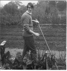
Photograph - Black and white print, A.P. Winzenried, Students Working in Vegetable Plots, 1950-1960
... The caption reads: Students working on individual plots: glass cloches were popular for a long time."...Male students working in their individual vegetable plots. Note the glass cloches. Fruit trees in the background....Students Working in Vegetable Plots Photograph Black and white print A.P. ...Appears as an illustration in, "Green Grows Our Garden," A.P. Winzenried p 90. The caption reads: Students working on individual plots: glass cloches were popular for a long time."Black and white photograph. Male students working in their individual vegetable plots. Note the glass cloches. Fruit trees in the background.On reverse, "1950's."glass cloches, green grows our garden, a.p. winzenried, vegetables, students working outside, male students, fruit trees, orchard -
 Bendigo Military Museum
Photograph - Capturing Topographic Features with a Wild B8, AUTOMAP 1 Systems Operations – Army Survey Regiment, Fortuna, Bendigo, 1980
... This is a set of 24 photographs of Air Survey Squadron technicians capturing topographic Features with a Wild B8 stereo plotter and operating AUTOMAP 1 equipment at the Army Survey Regiment at Fortuna, Bendigo, 1980. 17 of these photographs were taken of SPR Nick Van Dalen and SPR Santina (Argetto) Straube capturing topographic features – plotting with a Wild B8 stereo plotter were most likely taken in 1980. ...SPR Nick Van Dalen operating a Wild B8 stereo plotter. .18) to .24) Photo, black & white, 1980. ...See item 6185.4P for black & white copies of photos of SPR Santina (Argetto) Straube operating the Wild B8 stereo plotter. Refer to item 6204.8P for detailed information and additional photographs of the Wild B8 stereo plotter. ...This is a set of 24 photographs of Air Survey Squadron technicians capturing topographic Features with a Wild B8 stereo plotter and operating AUTOMAP 1 equipment at the Army Survey Regiment at Fortuna, Bendigo, 1980. 17 of these photographs were taken of SPR Nick Van Dalen and SPR Santina (Argetto) Straube capturing topographic features – plotting with a Wild B8 stereo plotter were most likely taken in 1980. See item 6185.4P for black & white copies of photos of SPR Santina (Argetto) Straube operating the Wild B8 stereo plotter. Refer to item 6204.8P for detailed information and additional photographs of the Wild B8 stereo plotter. The history of the AUTOMAP 1 system is covered in more detail with additional historic photographs in pages 116-118 of Valerie Lovejoy’s book 'Mapmakers of Fortuna – A history of the Army Survey Regiment’ ISBN: 0-646-42120-4. See items 6122.20P, 6183.19P, 6184.20P, 6200.5P, and 6222.17P for additional photographs of the AUTOMAP 1 system.This is a set of 24 photographs of Air Survey Squadron technicians capturing topographic features with a Wild B8 stereo plotter and operating AUTOMAP 1 equipment at the Army Survey Regiment at Fortuna, Bendigo, c1980. The photographic proofs were printed on photographic paper and are part of the Army Survey Regiment’s Collection. The photographic proof prints were scanned at 600 dpi. .1) to .8) Photo, black & white, 1980. SPR Santina (Argetto) Straube operating a Wild B8 stereo plotter. .9) to .17) Photo, black & white, 1980. SPR Nick Van Dalen operating a Wild B8 stereo plotter. .18) to .24) Photo, black & white, 1980. CPL Gerry Gunn undertaking AUTOMAP 1 computer system duties..1P to .24P – no annotations.automap 1, royal australian survey corps, rasvy, army survey regiment, army svy regt, fortuna, asr, photogrammetry -
 Bendigo Military Museum
Photograph - Capturing Topographic Features with a Wild B8, AUTOMAP 2 Systems Operations – Army Survey Regiment, Fortuna, Bendigo, 1990
... This is a set of two photographs of Air Survey Squadron technicians - LCPL Peter Murphy and SPR Rachel (Stanford) Scott capturing topographic features with a Wild B8 stereo plotter with AUTOMAP 2 equipment at the Army Survey Regiment, Fortuna, Bendigo, c1990. ...LCPL Peter Murphy operating a Wild B8 stereo plotter. .2) - Photo, colour, 1990. SPR Rachel (Stanford) Scott operating a Wild B8 stereo plotter....LCPL Peter Murphy operating a Wild B8 stereo plotter. .2) - Photo, colour, 1990. SPR Rachel (Stanford) Scott operating a Wild B8 stereo plotter. ...This is a set of two photographs of Air Survey Squadron technicians - LCPL Peter Murphy and SPR Rachel (Stanford) Scott capturing topographic features with a Wild B8 stereo plotter with AUTOMAP 2 equipment at the Army Survey Regiment, Fortuna, Bendigo, c1990. Refer to item 6185.4P and 6204.8P for detailed information and additional photographs of the Wild B8 stereo plotter. The history of the AUTOMAP 2 system is covered in more detail with additional historic photographs in pages 119, 137-142 and 180 of Valerie Lovejoy’s book 'Mapmakers of Fortuna – A history of the Army Survey Regiment’ ISBN 0-646-4: 2120-4. See items 6087.10P and 6223.23P for additional photographs of the AUTOMAP 2 system.This is a set of two photographs of Air Survey Squadron technicians capturing topographic features with a Wild B8 stereo plotter with AUTOMAP 2 equipment at the Army Survey Regiment at Fortuna, Bendigo, c1990. The photographs are on 35mm negative film. They are part of the Army Survey Regiment’s Collection. The photographic negatives were scanned at 96 dpi. .1) - Photo, colour, 1990. LCPL Peter Murphy operating a Wild B8 stereo plotter. .2) - Photo, colour, 1990. SPR Rachel (Stanford) Scott operating a Wild B8 stereo plotter..1P to .2P – no annotationsroyal australian survey corps, rasvy, army survey regiment, army svy regt, fortuna, asr, photogrammetry -
 National Vietnam Veterans Museum (NVVM)
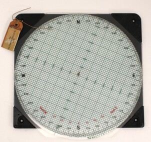
Instrument - Plotting Board, M19
... Standard issue item as used by Australian servicemen during conflict in Vietnam (1962-1973). Plotting boards are a secondary means of firing control for all mortars. ...The M19 plotting board consists of a rotating disk of transparent plastic and a removable range arm (missing), both attached to a flat round white grid base....Instrument Plotting Board, M19 ...Standard issue item as used by Australian servicemen during conflict in Vietnam (1962-1973). Plotting boards are a secondary means of firing control for all mortars. The user can determine deflection, azimuth, and range.The M19 plotting board consists of a rotating disk of transparent plastic and a removable range arm (missing), both attached to a flat round white grid base.North, South, East , West / Rotating disc calibrated with numbersplotting board, m19, mortar -
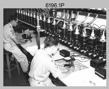 Bendigo Military Museum
Photograph - Multiplex mechanical stereoplotting equipment, Army Survey Regiment, Fortuna Bendigo, c1950s
... Multiplex equipment was imported from the UK in 1951 and introduced in the following year, to accelerate map production output covering CMF training areas at 1:25,000 map scale. Multiplex plotting was a productive advancement replacing the ‘Arundel’ method of graphical plotting planimetric detail that was expensive and slow, especially in timbered mountainous terrain. ...Unidentified technician laying down individual Multiplex plots.....1P to .2P, .4P – No annotations. .3P annotations identifying Multiplex components on front of photo. .5P annotated on front ‘Lay down of individual Multiplex plots at 1/14000 to framework of master grid to form Composite Compilation Sheet – Material Duralex.’...Multiplex equipment was imported from the UK in 1951 and introduced in the following year, to accelerate map production output covering CMF training areas at 1:25,000 map scale. Multiplex plotting was a productive advancement replacing the ‘Arundel’ method of graphical plotting planimetric detail that was expensive and slow, especially in timbered mountainous terrain. ...This is a set of five photographs of Multiplex mechanical stereoplotting equipment at the Army Survey Regiment, Fortuna Bendigo. c1950s. Multiplex equipment was imported from the UK in 1951 and introduced in the following year, to accelerate map production output covering CMF training areas at 1:25,000 map scale. Multiplex plotting was a productive advancement replacing the ‘Arundel’ method of graphical plotting planimetric detail that was expensive and slow, especially in timbered mountainous terrain. Air photos were made into small diapositives and mounted on racks in the exact position relative to when the aerial photos were taken. The technicians operated the Multiplex in a darkened room, with one photo projected with a green filter and the other through a red filter to form a 3D view of the overlapping photos. The 3D model projected onto a platen, which was a small platform that was raised up and down. The technician viewed the 3D image with special glasses fitted with red and green lenses. In the centre of the platen was a small pinhole that served as a floating mark, with a vertical pencil located exactly below the pinhole. This tracing table was moved to follow the topographic feature or contour line and draw it on the paper underneath. The technician raising or lowering the platform’s floating mark to match the height of the 3D terrain. It also replaced the slotted template method of mechanical adjustment of strips of aerial photography, however was restricted to each strip rather than between strips in the block. Although the Multiplex was phased out of production in 1968, it was used in the training of photogrammetry and aero-triangulation at the School of Military Survey located at Bonegilla, Victoria until the early 1990s. The history of the Multiplex is covered in more detail with additional historic photographs, in pages 50 to 51 of Valerie Lovejoy’s book 'Mapmakers of Fortuna – A history of the Army Survey Regiment’ ISBN: 0-646-42120-4.This is a set of five photographs of Multiplex mechanical stereoplotting equipment at the Army Survey Regiment, Fortuna, Bendigo. c1950s. The photographs were printed on photographic paper and are part of the Army Survey Regiment’s Collection. The photographs were scanned at 300 dpi. .1) - Photo, black & white, c1950s, unidentified personnel operating Multiplex equipment. .2) - Photo, black & white, c1950s, Multiplex equipment. .3) - Photo, black & white, c1950s, Multiplex components identified. .4) - Photo, black & white, c1950s, Multiplex optical components. .5) - Photo, black & white, c1950s. Unidentified technician laying down individual Multiplex plots..1P to .2P, .4P – No annotations. .3P annotations identifying Multiplex components on front of photo. .5P annotated on front ‘Lay down of individual Multiplex plots at 1/14000 to framework of master grid to form Composite Compilation Sheet – Material Duralex.’royal australian survey corps, rasvy, army survey regiment, army svy regt, fortuna, asr, photogrammetry -
 Bendigo Military Museum
Map - RASvy " Map Makers Exhibition 2025 "- Map display, RAN Hydrographic Office, 1972 - 1992
... This catalogue page shows the extent of the Australian area of responsibility for aeronautical charting. .2 RAAF PLOTTING CHART. NP 22-2 (Navigational Plotting) Tasmania. ...Current as at 30 Jun 92. .2 Extract of Navigational Plotting Chart " NP22-2 Tasmania " .3 Extract of Navigational Plotting Chart " NP 27 RAAF PLOTTING CHART AUSTRALIA - SOUTHEAST " .4 Extract of Navigational Plotting Chart " RAAF LONG RANGE PLOTTING CHART NP43-4 AUSTRALIA WESTERN " .5 Extract of Navigational Plotting Chart " RAAF LONG RANGE PLOTTING CHART NP43-7 SOLOMON ISLANDS " .6 Extract of Navigational Series " RAAF AIR STAFF PLANNING CHART NS 137-2 DARWIN NORTH WEST " .7 Extract of Navigational Series " RAAF AIR STAFF PLANNING CHART NS 137-1 DARWIN NORTH EAST " .8 Extract of Navigational Series " RAAF AIR STAFF PLANNING CHART NS 137-4 DARWIN SOUTH WEST " .9 Extract of Navigational Series " RAAF AIR STAFF PLANNING CHART NS 137-3 DARWIN SOUTH EAST " .10 Extract of Tactical Pilotage Chart " TPC R-13B " .11 Extract of Hydrographic Chart " PORT PHILLIP SOUTH and WEST CHANNELS " .12 Extract of Hydrographic Chart " GEELONG HARBOUR and APPROACHES " .13 Extract of En Route Chart " AUSTRALIA ERC HIGH " " H1 and H2 " ...This catalogue page shows the extent of the Australian area of responsibility for aeronautical charting. .2 RAAF PLOTTING CHART. NP 22-2 (Navigational Plotting) Tasmania. ...All of these Charts / Maps were used for the RSL Museum display " The Mapmakers " ( of RASvy. ) 10 Jun - 10 Aug 2025. .1 Catalogue of Tactical Pilotage Charts, 1:500 000 Scale. Digital Data Base available as at 30Jun 92. This catalogue page shows the extent of the Australian area of responsibility for aeronautical charting. .2 RAAF PLOTTING CHART. NP 22-2 (Navigational Plotting) Tasmania. MERCATOR PROJECTION. This series of charts were used for the training of RAAF Navigators. These charts were produced and printed at the Army Survey Regiment, Bendigo. .3 RAAF PLOTTING CHART AUSTRALIA - SOUTHEAST. NP 27 is Based on LAMBERT CONFORMAL CONIC PROJECTION. This series of charts was used by RAAF Navigators for the planning of RAAF flights. These charts were produced and printed at the Army Survey Regiment, Bendigo. .4 RAAF LONG RANGE PLOTTING CHART. NP 43-4 AUSTRALIA WESTERN. MERCATOR PROJECTION. This series of maps were used for the planning of RAAF flights. Of Particular note these charts were used to plot "Rhumb Lines or loxodromes" where a course crosses all Meridians (Lines of latitude and longitude) at the same angle. On Mercator projection charts Rhumb lines are conveniently shown as straight lines and are also lines of constant compass bearing. Rhumb lines are usually longer than the shortest distance between two points. The shortest distance between two points on the earth's surface is called a "Great Circle Route" which is a route on a circular path on the surface of the earth where the centre of that circle is also the centre of the earth. Great Circle Routes on a Mercator Projection are however curves and harder to plot. These charts were produced and printed at the Army Survey Regiment, Bendigo. .5 RAAF LONG RANGE PLOTTING CHART. NP 43-7 SOLOMON ISLANDS. MERCATOR PROJECTION. Used for the planning of RAAF flights. .6 RAAF AIR STAFF PLANNING CHART NS 137-1 DARWIN NORTH WEST. AZIMUTHAL EQUIDISTANT PROJECTION. This series of charts were used for planning by the staff. The whole chart was produced by joining the four quadrant maps together. The charts are based on a single point of tangency (in this case Darwin) and shows radius (distance) in nautical miles to and from that point. A series of charts were produced centred on each of the major airfields in Northern Australia. These charts were produced and printed at the Army Survey Regiment, Bendigo. .7 RAAF AIR STAFF PLANNING CHART NS 137-2 DARWIN NORTH EAST. AZIMUTHAL EQUIDISTANT PROJECTION. Used for the planning by the staff. The charts are based on a point of tangency and show radius in nautical miles. .8 RAAF AIR STAFF PLANNING CHART NS 137-4 DARWIN SOUTH WEST. AZIMUTHAL EQUIDISTANT PROJECTION. Used for the planning by the staff. The charts are based on a point of tangency and show radius in nautical miles. .9 RAAF AIR STAFF PLANNING CHART NS 137-3 DARWIN SOUTH EAST. AZIMUTHAL EQUIDISTANT PROJECTION. Used for the planning by the staff. The charts are based on a point of tangency and show radius in nautical miles. .10 TACTICAL PILOTAGE CHART. TPC R-13B. LAMBERT CONFORMAL PROJECTION. Used by pilots for flight planning and could be used in flight if necessary for visual navigation using major ground features shown on the chart. These charts also contained aeronautical information such as airfields, radio navigation beacons and obstructions. Contours and height information was shown in feet to be compatible with aircraft altimeters. Each graticule square also contained a Maximum Safe Elevation Figure (MEF) also in feet. Coverage of this series over Australia's area of interest were produced and printed at the Army Survey Regiment, Bendigo. .11 HYDROGRAPHIC CHART. AUS 158. PORT PHILLIP SOUTH and WEST CHANNELS. PROJECTION TRANSVERSE MERCATOR. Used by all people needing to navigate a vessel. Hydrographic charts were printed at the Army Survey Regiment, Bendigo. .12 HYDROGRAPHIC CHART. AUS 157. GEELONG HARBOUR and APPROACHES. PROJECTION TRANSVERSE MERCATOR. Used by all people needing to navigate a vessel. .13 EN ROUTE CHART. AUSTRALIA ERC HIGH. H1 and H2. LAMBERT CONFORMAL CONIC PROJECTION. This series of charts were regularly produced by the RAAF Aeronautical Information Service (AIS) and contained current aeronautical information for pilots. These charts were printed at the Army Survey Regiment, Bendigo..1 Tactical Pilotage Chart Series Catalogue. Current as at 30 Jun 92. .2 Extract of Navigational Plotting Chart " NP22-2 Tasmania " .3 Extract of Navigational Plotting Chart " NP 27 RAAF PLOTTING CHART AUSTRALIA - SOUTHEAST " .4 Extract of Navigational Plotting Chart " RAAF LONG RANGE PLOTTING CHART NP43-4 AUSTRALIA WESTERN " .5 Extract of Navigational Plotting Chart " RAAF LONG RANGE PLOTTING CHART NP43-7 SOLOMON ISLANDS " .6 Extract of Navigational Series " RAAF AIR STAFF PLANNING CHART NS 137-2 DARWIN NORTH WEST " .7 Extract of Navigational Series " RAAF AIR STAFF PLANNING CHART NS 137-1 DARWIN NORTH EAST " .8 Extract of Navigational Series " RAAF AIR STAFF PLANNING CHART NS 137-4 DARWIN SOUTH WEST " .9 Extract of Navigational Series " RAAF AIR STAFF PLANNING CHART NS 137-3 DARWIN SOUTH EAST " .10 Extract of Tactical Pilotage Chart " TPC R-13B " .11 Extract of Hydrographic Chart " PORT PHILLIP SOUTH and WEST CHANNELS " .12 Extract of Hydrographic Chart " GEELONG HARBOUR and APPROACHES " .13 Extract of En Route Chart " AUSTRALIA ERC HIGH " " H1 and H2 " royal australian survey corps, rasvy, fortuna, detachment - army survey regiment, army svy regt, asr -
 Running Rabbits Military Museum operated by the Upwey Belgrave RSL Sub Branch
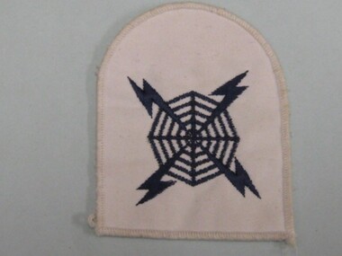
Rating Badge
... Rating Badge. Radar plotter...Running Rabbits Military Museum operated by the Upwey Belgrave RSL Sub Branch 1 Mast Gully Road Upwey melbourne Badge/Buttons RAN Rating Badge. Radar plotter Rating Badge ...Rating Badge. Radar plotterbadge/buttons, ran -
 Bendigo Military Museum
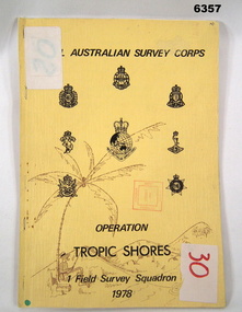
Administrative record - Royal Australian Survey Corps - Operation Tropic Shores, 1 Field Survey Squadron 1978, 31 Aug 1978
... The Operation was the field completion of Cape York 1;50,000 Mapping North of latitude 15 degrees S. Plotting was undertaken by 2, 4 and 5 Fd Svy Sqns with 1Fd Svy Sqn undertaking the mounting and Management of the field completion phase. ...Booklet, A4 cream cardboard cover, stapled Left Hand side, containing a report and plotted maps. Cover has Title and the Badges of the Australian Army Corps who participated in the Operation. ...The Operation was the field completion of Cape York 1;50,000 Mapping North of latitude 15 degrees S. Plotting was undertaken by 2, 4 and 5 Fd Svy Sqns with 1Fd Svy Sqn undertaking the mounting and Management of the field completion phase. ...Operation Tropic Shores was conducted in 2 phases, Sep 1977 and May / Jun 78. The Operation was the field completion of Cape York 1;50,000 Mapping North of latitude 15 degrees S. Plotting was undertaken by 2, 4 and 5 Fd Svy Sqns with 1Fd Svy Sqn undertaking the mounting and Management of the field completion phase. Re-visiting and targeting of existing trig stations was also carried out as an opportunity task.Booklet, A4 cream cardboard cover, stapled Left Hand side, containing a report and plotted maps. Cover has Title and the Badges of the Australian Army Corps who participated in the Operation. 2 fd svy sqn, 4 fd svy sqn, 5 fd svy sqn, royal australian survey corps, 1 field survey squadron, 1fd svy sqn, rasvy, fortuna, army survey regiment, army svy regt, asr -
 City of Moorabbin Historical Society (Operating the Box Cottage Museum)
Certificate - Document, Certificate of Burial 1890, c1880
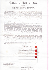
... Sadly Martha Jones born 1888 died in 1890 and James Jones had to purchase this plot at Brighton General Cemetery for her burial. ...An original paper Certificate of Right of Burial in The Brighton General Cemetery signed and dated by the Trustees of the Cemetery upon the application of James Jones of East Brighton, Victoria, 22nd April 1890. A plot , Register No. 2844, of 4 feet in width and 8 feet in depth in the Wesleyan Section, No. 199, compartment G in the Brighton General Cemetery. would be supplied upon payment of Two Pounds two shillings and receipt of same is acknowledged. ...Application of Mr James Jones of East Brighton for a plot to be supplied upon payment of Two Pounds and 2 Shillings and receipt of same acknowledged. ...Sadly Martha Jones born 1888 died in 1890 and James Jones had to purchase this plot at Brighton General Cemetery for her burial. ...James Jones was the son of Philip Jones, a Chairmaker, and Ann Jones who settled in East Brighton after the sale of land c1852 in the area of the Henry Dendy Special Survey of 1841. Mary Ann Moore was the daughter of Thomas Moore, a Gardener, and Sarah Harris who also settled in Brighton c1852. James and Mary Ann Jones settled and raised their family in East Brighton now Bentleigh. Mr John Herron resided at 4 Vickery St Bentleigh until 1989. Sadly Martha Jones born 1888 died in 1890 and James Jones had to purchase this plot at Brighton General Cemetery for her burial. A further 2 children were interred in 1893 and 1900 then Mary Ann in 1903 and James in 1940 James Jones and Mary Ann Moore were born in Brighton c1857 and c 1859 into pioneer market gardener families in the area of the Dendy Special Survey of 1841. They married in 1883 and raised their family in East Brighton, now Bentleigh. Sadly infectious diseases took the lives of many infants throughout the Colony of Victoria due to the poor state of water supply and sewerage disposal and locally the swamps of the Elster Creek were a constant breeding ground.An original paper Certificate of Right of Burial in The Brighton General Cemetery signed and dated by the Trustees of the Cemetery upon the application of James Jones of East Brighton, Victoria, 22nd April 1890. A plot , Register No. 2844, of 4 feet in width and 8 feet in depth in the Wesleyan Section, No. 199, compartment G in the Brighton General Cemetery. would be supplied upon payment of Two Pounds two shillings and receipt of same is acknowledged. Certificate of Right of Burial / IN THE / BRIGHTON GENERAL CEMETERY. Application of Mr James Jones of East Brighton for a plot to be supplied upon payment of Two Pounds and 2 Shillings and receipt of same acknowledged. Signed by the Trustees of the Cemetery, (4 signatures) in presence of S. Simmonds, dated twenty- second April 1890 Reverse side Dated 22nd April 1890 / Certificate of Right of Burial / IN THE / BRIGHTON GENERAL CEMETERY/ Mr James Jones ( hand written) / DENOMINATION Wesleyan / Compartment G / No. 199 Hand written on right side 3454 (signed) S Simmonds / 4797 (signed) S Simmonds / 36897 20/ 11 / 40 melbourne, brighton, moorabbin, water supply, pioneers, bentleigh, dendy henry, market gardeners, early settlers, jones mary ann, wesleyan church, jones james, vaccination, typhoid, dendys special survey 1841, infectious diseases, elster creek, jones martha, brighton general cemetery -
Stawell Historical Society Inc
Map - Plan, Glenorchy Cemetery, c 1960
... Printed map of plots on backing card...Stawell Historical Society Inc 46 Longfield St Stawell grampians Burials Scale 1 inch to 12 feet Printed map of plots on backing card Glenorchy Cemetery Map Plan ...Printed map of plots on backing cardScale 1 inch to 12 feetburials -
 University of Melbourne, Burnley Campus Archives
Photograph - Black and white print, Student Working in Vegetable Plot
... Student Working in Vegetable Plot...Male student working in vegetable plot...University of Melbourne, Burnley Campus Archives 500 Yarra Boulevard Richmond melbourne male students vegetable plot student working outside orchard Male student working in vegetable plot Student Working in Vegetable Plot Photograph Black and white print ...Male student working in vegetable plotmale students, vegetable plot, student working outside, orchard -
University of Melbourne, Burnley Campus Archives
Slide - Glass slide, 1891-1905
... '-Fernbank.- School Plots.-' Frame missing....University of Melbourne, Burnley Campus Archives 500 Yarra Boulevard Richmond melbourne school gardens australia fernbank '-Fernbank.- School Plots.-' Frame missing. Slide Glass slide ...'-Fernbank.- School Plots.-' Frame missing.school gardens, australia, fernbank -
University of Melbourne, Burnley Campus Archives
Slide - Glass slide, 1891-1905
... South Buchan Agric. Plot.-'...South Buchan Agric. Plot.-' Slide Glass slide ...'7. South Buchan Agric. Plot.-'school gardens, australia, south buchan -
![Artillary Plotting Board [First World War], Atrifact](/media/collectors/57fb2d7ed0cdd1171412db8e/items/595b17c9d0cde50bd4e596f3/item-media/595b1904d0cde50bd4e64252/item-fit-380x285.jpg?cb=6) Highett RSL Sub Branch Inc
Highett RSL Sub Branch IncArtillary Plotting Board [First World War], Atrifact
... WW1 Artillery Plotting board donated by George Thorp...Atrifact Artillary Plotting Board [First World War] ...Timer board cut in to a quadrant mounted with Brass side rules.WW1 Artillery Plotting board donated by George Thorp -
University of Melbourne, Burnley Campus Archives
Photograph, 9, 1929
... 3 female students digging in the flower plots. ...University of Melbourne, Burnley Campus Archives 500 Yarra Boulevard Richmond melbourne female students digging flower plots October 1929. 3 female students digging in the flower plots. 9 Photograph ...3 female students digging in the flower plots. October 1929.female students, digging, flower plots -
 University of Melbourne, Burnley Campus Archives
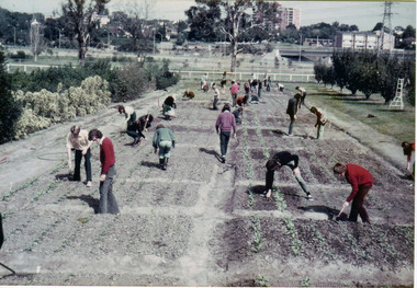
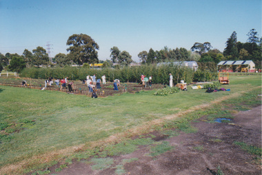
Photograph - Colour print, Students Working in Vegetable Plots, Unknown
... Students working in vegetable plots....Students working in vegetable plots. Students Working in Vegetable Plots Photograph Colour print ...Colour photograph. Students working in vegetable plots.vegetable plots, orchard, students working outside, field station