Showing 127 items matching "point ormond"
-
 Melbourne Tram Museum
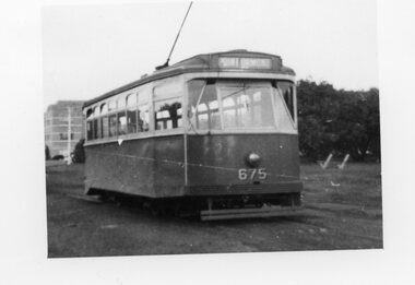
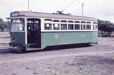
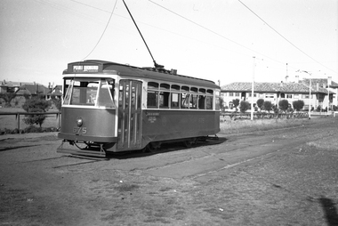
Photograph - X2 675 at Point Ormond, Bob Lilburn, 1960
... X2 675 at Point Ormond...Point Ormond...The Point Ormond line closed on 22/10/1960. The closure...Photo of X2 675 at Point Ormond - actual photo 55x72mm... The Point Ormond line closed on 22/10/1960. The closure ...The Point Ormond line closed on 22/10/1960. The closure of the Footscray lines in 1962 saw the withdrawal and scrapping of this small 4 wheeler trams.Yields information about X2 675 at Point Ormond terminusPhoto of X2 675 at Point Ormond - actual photo 55x72mm on larger sheet 120x166mmtramways, transport, x2 class, tram 675, point ormond -
 Melbourne Tram Museum
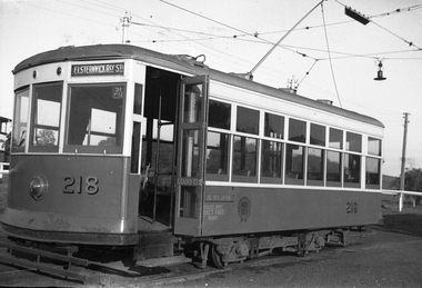
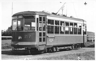
Photograph - X class 217 at Point Ormond, 15-1-1954
... X class 217 at Point Ormond...Point Ormond...The photograph shows X class 217 at Point Ormond terminus...In ink on rear "Birney car 217,at Point Ormond 15-1-54...The photograph shows X class 217 at Point Ormond terminus ...The photograph shows X class 217 at Point Ormond terminus in Glen Huntly Road with a MMTB bus passing in the background. Photographer unknown, dated 15-1-1954.Yields information the Point Ormond terminus in 1954.Black and white photograph with notes on the rear.In ink on rear "Birney car 217,at Point Ormond 15-1-54, with MMTB bus in the background" and "1037".tramcars, tramways, point ormond, x class, tram 217 -
 St Kilda Historical Society
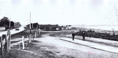
Photograph, Point Ormond Estate, c. 1915?
... Point Ormond Estate...Melbourne Suburbs, St Kilda. View looking south from Point...Point Ormond, Elwood, Victoria, Australia.... View looking south from Point Ormond Estate, Elwood black ...black and white photographMelbourne Suburbs, St Kilda. View looking south from Point Ormond Estate, Elwood -
 Melbourne Tram Museum
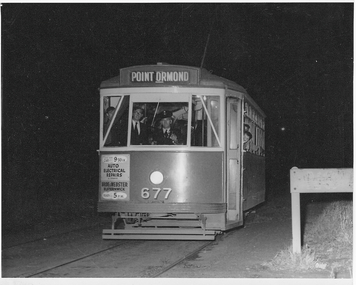
Photograph - X2 677 Point Ormond Last Car, Jim Seletto, 22 October 1960
... X2 677 Point Ormond Last Car...Point Ormond... with the destination of Point Ormond at the western end of Glen Huntly Rd...In pencil on rear: 'Last car ex Point Ormond, 10.30pm Oct... and Point Ormond terminus. Trams Point Ormond Glen Huntly Rd tram ...The photograph shows X2 class tram No. 677 with the destination of Point Ormond at the western end of Glen Huntly Rd at that location. Dark exterior becasue this was 10.30pm in parkland. This was the last car before the line closed to revenue service. Photo by Jim Seletto 22 October 1960Yields information about MMTB X2 and Point Ormond terminus.Black and white photograph with photographer's notes on rear In pencil on rear: 'Last car ex Point Ormond, 10.30pm Oct 22 60. Photo J Seletto JSE10'trams, point ormond, glen huntly rd, tram 677, x2 class, trramways -
 Melbourne Tram Museum
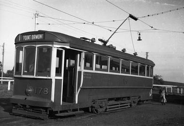
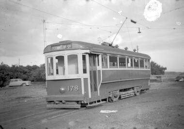
Negative - T class 178 at Point Ormond, Wal Jack, c1950
... T class 178 at Point Ormond... Point Ormond...Photograph by Wal Jack, of T class 178 at Point Ormond...Photograph by Wal Jack, of T class 178 at Point Ormond ...Photograph by Wal Jack, of T class 178 at Point Ormond, c1950. Has a destination of Point Ormond.Yields information about one-man operation of Point Ormond trams.Black and white negative.trams, tramways, t class, point ormond, tram 178 -
 Melbourne Tram Museum
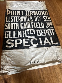
Functional object - Destination Roll, Melbourne & Metropolitan Tramways Board (MMTB), "Point Ormond", 1940s
... "Point Ormond"...Point Ormond... trams used on the Point Ormond line. Has stenciled word "STOP... trams used on the Point Ormond line. Has stenciled word "STOP ...Roll used at the MMTB Glen Huntly Depot for the four-wheel trams used on the Point Ormond line. Has stenciled word "STOP" on the top and the bottom, stencilled miniature destinations on the rear to assist drivers in locating the destination. The line between Elsternwick and Point Ormond was closed on 22/10/1960.Demonstrates a destination roll for the short Point Ormond line.Destination roll - white lettering on a black background on a linen or book binding material. trams, tramways, mmtb, destination roll, point ormond -
 Melbourne Tram Museum
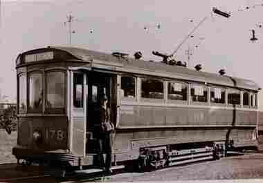
Photograph - T class 178 at Point Ormond
... T class 178 at Point Ormond...Point Ormond...Photo of T class tram 178 at the Point Ormond terminus...Photo of T class tram 178 at the Point Ormond terminus ...Photo of T class tram 178 at the Point Ormond terminus. The driver who is also the conductor for a one-man operation is standing the doorway of the tram. Photographer and date unknown.Yields information about tram 178 at the Point Ormond Terminus.Black and white print with plain back.tramways, t class, tram 178, point ormond, trams -
 St Kilda Historical Society
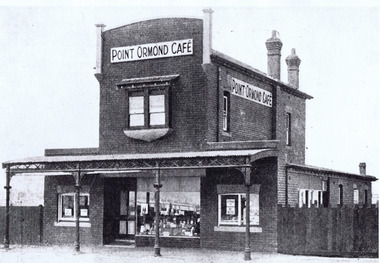
Photograph, Point Ormond Cafe, c. 1915?
... Point Ormond Cafe ...Point Ormond, St Kilda, Vic, Australia... Library of Australia black and white photograph Point Ormond Cafe ...black and white photographWritten on back: St Kilda By the Sea Annual p.102, season 1915/16F600:65. Stamped: National Library of Australia -
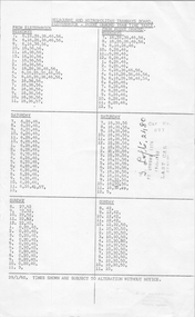 Melbourne Tram Museum
Ephemera - Point Ormond Timetable, Last Tram record, 22-10-1960
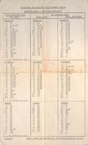
... Point Ormond Timetable...Point Ormond... or Point Ormond for each day of the week. The sheet records... about the Point Ormond Service prior to its closure and records ...The MMTB Timetable details the trips from Elsternwick or Point Ormond for each day of the week. The sheet records the time of the last tram, 1036pm, driver G Loft No. 2480, and the tram as X2 677 on 22-10-1960. The donor advised that the MMTB following the practice adopted for the Bourke St changeover in 1940, the MMTB chose to pull the tram service before the last advertised trip for the day. Those present to ride the last started early and rode up and down for quite a few runs, then, on one arrival at Elsternwick Station, the Inspector (known as grasshoppers or Braids) on board instructed the driver to keep going and we rode through to GH Depot without paying another fare. They noted a half-cab bus, destination 'Clifton Hill', lurking ready to take up the running. The donor reported (and as you will see from the endorsements on the timetable) “I circled the time of the last run and got the signature and badge number of the driver. The rubber-stamp impressions were also applied to souvenir tickets (3d).” Yields information about the Point Ormond Service prior to its closure and records details of the last tram service.Foolscap Gestetner duplicated sheet, dated 29/1/1960Marked to show the last tram on 22-10-1960, time, tramcar and driver's name and number.tramways, timetables, tram 677, point ormond, closure, last tram -
 St Kilda Historical Society
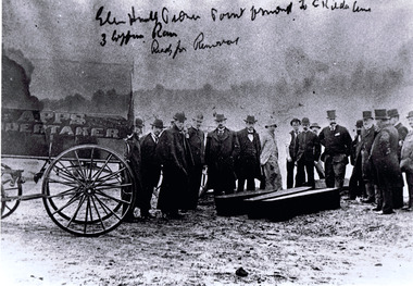
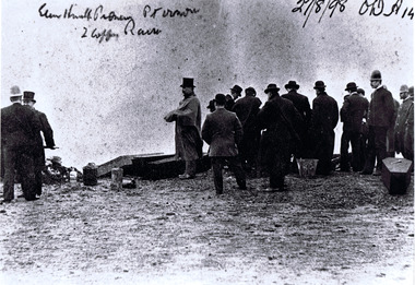
Photograph, Exhumation of Glen Huntly Pioneers, 27/08/1898
... Exhumation of Glen Huntly Pioneers at Point Ormond on 27...Glenhuntly road, Point Ormond to St Kilda line. 3 coffin...Point Ormond, Elwood, Victoria, Australia... Pioneers at Point Ormond on 27 August 1898 Glenhuntly road, Point ...Exhumation of Glen Huntly Pioneers at Point Ormond on 27 August 1898black and white photograph accompanied by a copyGlenhuntly road, Point Ormond to St Kilda line. 3 coffin row, ready for removal. Apps Undertaker. Robe st St Kilda -
 St Kilda Historical Society
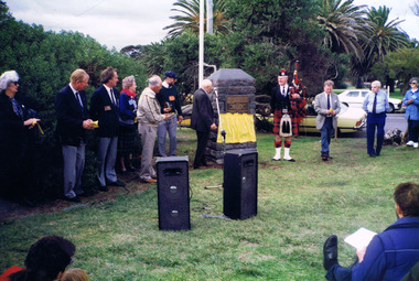
Photograph, 'Glen Huntley' 150th anniversary of arrival - images collection
... Point Ormond...Point Ormond Quarantine Station Cairn, Glenhuntly Road... Buntine Elwood Point Ormond Glen Huntley Inscription on 150th ...Victorias first quarantine station was established in Port Ormond on 24 April 1840 when the government immigrant ship "Glen Huntley" arrived in the Port Phillip District flying the yellow quarantine flag . The site is marked by a cairn and plaque that was unveiled in 1985. In 1990 a second plaque was affixed to the cairn to mark the 150th anniversary of the arrival of the ship. It was unveiled at a gathering of descendants of the original passengers on 22 April 1990 by the oldest known descendant, Albert John Buntine MM.Colour photographInscription on 150th anniversary plaque: This plaque commemorates the 150th anniversary of the arrival of the ship 'Glen Huntley' at a gathering of descendants of the original passengers. Unveiled on April 22nd 1990 by Albert John Buntine MM, aged 95. Oldest known descendent. Anderson, Davidosn, Dingwall, McCleery, McDougal, McIntosh, Pattison, Somerville, Brisbane, Kirkwood, McGaskell, McDonald, McGregor, McKenzie, Turnbull, Walker, Armstrong, Henderson, Mathewson, McPherson, Robertson, McKinnon, Whitlock, Stewart, Cameron, Cummins, Hewison, Maskill, Mathers, McKinan, McKinny, McLaren, Burnie, Clarke, Denham, Fraser, Harper, Mercer, McColl, McLeod, Clarke, Duff, Roy, Seat, Stow, Tait, Ward, Craig, Grant, McKay, Mefan, Munro, Nicol, Smith, Young. The plaque marking the 150th anniversary of the ship's arrival was placed below the plaque that was attached to the cairn in 1985. The inscription on the original plaque is: This cairn marks the site of Victorias first quarantine station, which was established on the 24th April 1840 when the government emigrant ship "Glen Huntley" arrived in the Port Phillip District flying the yellow quarantine flag. The site became St Kilda's first official burial ground and the graves of the early colonists remained here until 1898 when the remains were re-interred in the St Kilda Cemetery. Unveiled by the Hon. R W Walsh MLA Member for Albert Park, Minister for Public Works, Assistant Minister for Employment and Industrial Affairs, 7th November 1985. This project was initiated by the Historical Society of St Kilda and sponsored by the Lions Club of Elwood for the 150th Anniversary of the State of Victoria. Logo Victoria 150.glen huntly, glenhuntly, albert john buntine, elwood, point ormond, glen huntley -
 St Kilda Historical Society
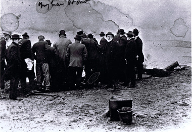
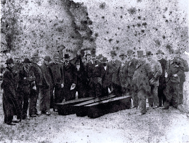
Photograph, Exhumation of Glen Huntly Pioneers, 27/08/ 1898
... Exhumation of Glen Huntly Pioneers at Point Ormond ...Point Ormond, Elwood, Victoria, Australia... Pioneers at Point Ormond (?) grave Pt Ormond black and white ...Exhumation of Glen Huntly Pioneers at Point Ormond black and white photograph copy(?) grave Pt Ormond -
 St Kilda Historical Society
Print, Exhumation of Glen Huntly Pioneers, 27/08/ 1898
... Exhumation of Glen Huntly Pioneers at Point Ormond ...Point Ormond, Elwood, Victoria, Australia... Pioneers at Point Ormond Glen Huntly Pioneer Pt Ormond. 2 coffin ...Exhumation of Glen Huntly Pioneers at Point Ormond black and white photograph copyGlen Huntly Pioneer Pt Ormond. 2 coffin rows. 27/8/98 OW A 14 -
 St Kilda Historical Society
Photograph, Exhumation of Glen Huntly Pioneers, 27/08/ 1898
... Exhumation of Glen Huntly Pioneers at Point Ormond. 3...Point Ormond, Elwood, Victoria, Australia... Pioneers at Point Ormond. 3 coffins black and white photograph ...Exhumation of Glen Huntly Pioneers at Point Ormond. 3 coffinsblack and white photograph, copy (original poor conditions) -
 Melbourne Tram Museum
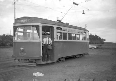
Slide, Keith Caldwell, 11/03/1960 12:00:00 AM
... Point Ormond... dated 11 March 1960, of X2 675 at the Point Ormond Terminus... Trams tramways Point Ormond X2 class tram 675 hand stamped "12 ...Agfa Colour slide, cardboard mount, by Keith Caldwell dated 11 March 1960, of X2 675 at the Point Ormond Terminus. Has the destination of Point Ormond.hand stamped "12 Mar '60"trams, tramways, point ormond, x2 class, tram 675 -
 Melbourne Tram Museum
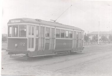
Photograph - Black & White Photograph/s, 1950's?
... Point Ormond...Black and white photograph of R 172 at the Point Ormond... Trams tramways Point Ormond Conductors Bag R Class tram 172 ...Black and white photograph of R 172 at the Point Ormond Terminus. Tram has the destination of Point Ormond. Photograph has faded. No known details of the photographer or date.trams, tramways, point ormond, conductors bag, r class, tram 172 -
 Melbourne Tram Museum
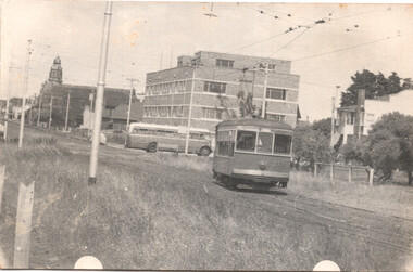
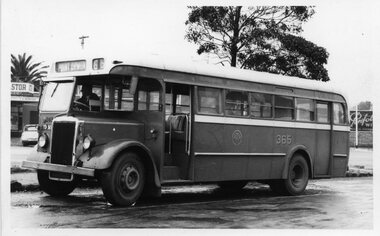
Photograph, Melbourne & Metropolitan Tramways Board (MMTB), MMTB Bus 365 Leyland OPS1 chassis. Preston Workshops body, at 21 May 1955
... point ormond...Photo of MMTB Bus 365 on the Point Ormond route.... MMTB Buses Leyland Preston Workshops point ormond Photo of MMTB ...The MMTB operated buses as well as trams. This was one of the many Leyland OPS1s.Yields information about an early MMTB BusPhoto of MMTB Bus 365 on the Point Ormond route.tramways, mmtb buses, leyland, preston workshops, point ormond -
 Melbourne Tram Museum
Photograph - Black & White Photograph/s, 1950's?
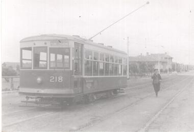
... Point Ormond... bag) reversing the pole of X 218 at the Point Ormond Terminus... Trams tramways Point Ormond Conductors Bag X class tram 218 ...Black and white photograph of the driver (with conductor's bag) reversing the pole of X 218 at the Point Ormond Terminus. Tram has the destination of Point Ormond. Photograph has faded. No known details of the photographer or date.trams, tramways, point ormond, conductors bag, x class, tram 218 -
 Melbourne Tram Museum
Document - Timetable - MMTB bus routes 1962 and 1963, Melbourne & Metropolitan Tramways Board (MMTB)
... Point Ormond... of the Clifton Hill to Elsternwick route to Point Ormond after.... .5 - Deer Park - City - 14/11/1962 .6 - Clifton Hill - Point... Hill to Elsternwick route to Point Ormond after the closure ...Produced by the MMTB to provide timetable information on Melbourne bus routes to passengers. Shows the extension of the Clifton Hill to Elsternwick route to Point Ormond after the closure of tram service to Point Ormond and for services that replaced the Footscray tram lines.Shows the method of production of timetables in the early 1960s.Set of 7 bus timetables, duplicated sheets as noted below - printed on foolscap sheets. .1 - Sunshine Park - City - 15/3/1963 - single sheet .2 - Sunshine (via South and Dynon Roads) - City Bus - 20/7/1962 - single sheet .3 -Garden City - City - undated - single sheet .4 - Queens Bridge - Fisherman's Bend, - via various routes - June 1963, four sheets stapled in top left hand corner. .5 - Deer Park - City - 14/11/1962 .6 - Clifton Hill - Point Ormond - Esternwick - undated .7 - Ballarat Road - Footscray Station - Williamstown Rd - Russell St - 15/6/1962 - three sheets stapled in top left hand corner.timetables, buses, mmtb, footscray, sunshine, fisherman's bend, clifton hill, point ormond, garden city, bus replacement -
 Melbourne Tram Museum
Negative, Travis Jeffrey, 5/09/1960 12:00:00 AM
... Point Ormond...Negative of tram T 178 at Point Ormond terminus. Tram has... Trams tramways T Class Point Ormond Elsternwick tram 178 Paper ...Negative of tram T 178 at Point Ormond terminus. Tram has destination Elsternwick Railway StationPaper folder that contained the negative had "NR41A" in red ink, "PD1" in pencil, 31 in blue ink, date stamp "5 Sep 1960" on front.trams, tramways, t class, point ormond, elsternwick, tram 178 -
 Melbourne Tram Museum
Negative, Wal Jack, 1940's
... Point Ormond...Black and white negative by Wal Jack of X2 675 at the Point... Trams tramways X2 class Point Ormond tram 675 Black and white ...Black and white negative by Wal Jack of X2 675 at the Point Ormond terminus. Photo mid 1940's?trams, tramways, x2 class, point ormond, tram 675 -
 Melbourne Tram Museum
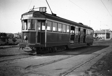
Negative, Wal Jack, c1939
... Point Ormond...Black and white negative, by Wal Jack, of W2 586 at Point... Trams tramways W2 class Point Ormond Route 66 tram 586 Black ...Black and white negative, by Wal Jack, of W2 586 at Point Ormond showing Route 66, Darling Road. c1939trams, tramways, w2 class, point ormond, route 66, tram 586 -
 Melbourne Tram Museum
Negative, Travis Jeffrey, 30/05/1960 12:00:00 AM
... Point Ormond...Negative of tram X2 675 at Point Ormond terminus. Tram has... Trams tramways X2 class Point Ormond tram 675 Paper folder ...Negative of tram X2 675 at Point Ormond terminus. Tram has destination Elsternwick Railway Station. Conductor standing in doorway posing for photographer.Paper folder that contained the negative had "NR37A" written in red ink, "27A" and "Melb" written in blue ink, and date stamped as 30 May 1960.trams, tramways, x2 class, point ormond, tram 675 -
 Melbourne Tram Museum
Negative, Wal Jack, c1950
... Point Ormond... at the Point Ormond terminus, c1950. Tram has the destination... Trams tramways Point Ormond X class tram 218 Black and white ...Black and white negative, by Wal Jack, of X class 218 at the Point Ormond terminus, c1950. Tram has the destination of Elsternwick Railway Station.trams, tramways, point ormond, x class, tram 218 -
 Melbourne Tram Museum
Negative, Wal Jack, mid 1950's
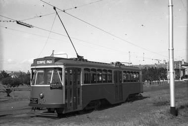
... Point Ormond... tour at Point Ormond, with destination of Olympic Park. Photo... Trams tramways AETA tour Point Ormond Y1 Class tram 610 Black ...Black and white negative, by Wal Jack, Y1 610 of an AETA tour at Point Ormond, with destination of Olympic Park. Photo possibly mid 1950'strams, tramways, aeta tour, point ormond, y1 class, tram 610 -
 Melbourne Tram Museum
Photograph - Black and White photograph, Ron Scholten, 1960s
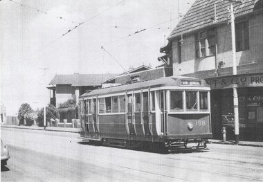
... Point Ormond... image onto A4 page of Q 198 at Elsternwick with a Point Ormond...Trams tramways Q class Elsternwick Point Ormond tram 198 ...Black and White photograph, laser printed from a digital image onto A4 page of Q 198 at Elsternwick with a Point Ormond Destination. No source information provided or known at time of cataloguing.trams, tramways, q class, elsternwick, point ormond, tram 198 -
 Melbourne Tram Museum
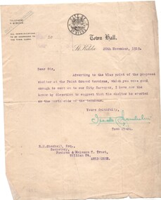
Letter, City of St Kilda, shelter shed on the corner of St Kilda Road and High St, 20/11/1919 12:00:00 AM
... Point Ormond... regarding the shelter location at the Point Ormond terminus... Trams tramways PMTT Letters City of St Kilda Point Ormond ...Letter - City of St Kilda - dated 20/11/1919, to the Secretary of the Prahran and Malvern Tramways Trust Mr. R. Shackell regarding the shelter location at the Point Ormond terminus - suggesting being placed on the north side.trams, tramways, pmtt, letters, city of st kilda, point ormond, shelters -
 Ballarat Tramway Museum
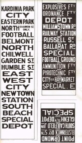
Drawing - Destination Roll - miniatures, Australian Electric Traction Association (AETA), mid 1960's?
... Point Ormond... on heavy paper: .1 - Geelong .2 - Footscray .3 - Point Ormond .4... Ballarat Bendigo Destination Roll Point Ormond Reproduction ...Reproduction or miniatures of tram destination rolls on heavy paper: .1 - Geelong .2 - Footscray .3 - Point Ormond .4 - Ballarat .5 - Bendigo All white on black except for Geelong. Possibly made early to mid 1960's by the AETAtram, trams, geelong, footscray, ballarat, bendigo, destination roll, point ormond -
 Melbourne Tram Museum
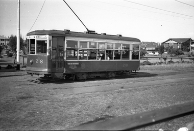
Photograph - Set of 2 Black & White Photograph/s, Keith Kings, 13/08/1949 12:00:00 AM
... Point Ormond...Black and White photographs of X class trams at the Point... Trams tramways X class Point Ormond One Man Trams tram 217 tram ...Black and White photographs of X class trams at the Point Ormond terminus by Keith Kings. Photos shows the lettering and signs for one man trams. .1 - X-217 - 13/8/1949 .2 - X-218 - 29/4/1950On the rear in ink details of each tram and photo along with Keith's photo numbers c(e)(4) and D(k)(7).trams, tramways, x class, point ormond, one man trams, tram 217, tram 218 -
 Melbourne Tram Museum
Negative, Wal Jack collection, c1940
... Point Ormond... at the Point Ormond terminus. Note the Pay as you enter sign... Trams tramways X class Birney Point Ormond tram 218 Black ...Black and white negative by Wal Jack of X class Birney 218 at the Point Ormond terminus. Note the Pay as you enter sign, There appears to be a two many crew, the driver is chatting to the conductor in the front of the tram, with a summer jacket on. Tram has the destination of Elsternwick. Photo c1940.trams, tramways, x class, birney, point ormond, tram 218