Showing 215 items matching "polaroid"
-
 Broadmeadows Historical Society & Museum
Equipment - Camera, 1976 - 1977
... Polaroid Instant Camera - Model EE 33, Black plastic with Brown Face...Face: Polaroid / EE/ 33...Polaroid...Broadmeadows Historical Society & Museum 21 Pearcedale Parade Broadmeadows melbourne Photography; Instant Photograph; Camera Addition to Timeline for amateur photography Camera Photography Amateur Face: Polaroid / EE/ 33 Polaroid Instant Camera - Model EE 33, Black plastic with Brown Face Equipment Camera Polaroid ...Photography; Instant Photograph; CameraAddition to Timeline for amateur photographyPolaroid Instant Camera - Model EE 33, Black plastic with Brown FaceFace: Polaroid / EE/ 33camera, photography, amateur -
 B-24 Liberator Memorial Restoration Australia Inc
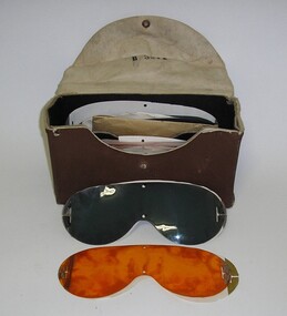
Polaroid Lenses for 1068 Goggles, 1940s
... Brown Box containing 4 green, 4 orange and 2 clear replacement lenses for Polaroid 1068 Goggles....Polaroid Aviation Goggles Kit No. 1068....Polaroid Corporation...Polaroid Lenses for 1068 Goggles Polaroid Corporation ...Used by airmen in WWIIBrown Box containing 4 green, 4 orange and 2 clear replacement lenses for Polaroid 1068 Goggles.Polaroid Aviation Goggles Kit No. 1068.a9 -
 Moorabbin Air Museum
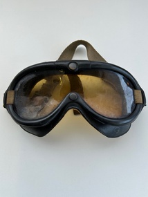
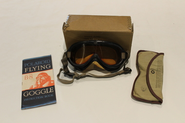
Accessory (Item) - Aviation Goggle Polaroid B-8 No.1065
... Aviation Goggle Polaroid B-8 No.1065....Aviation goggle Polaroid B-8 No.1065.Moulded into the rubber just above the nose is "Polaroid Aviation Goggle No.1065 TM REG.U.S. ...Aviation Goggle Polaroid B-8 No.1065. Accessory Aviation Goggle Polaroid B-8 No.1065. ... -
 Yarrawonga and Mulwala Pioneer Museum
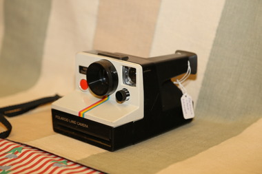
Camera, Polaroid Land Camera 100 One step
... Polaroid Land Camera 100 One step...Polaroid land camera and one step inscription on Cream face...Yarrawonga and Mulwala Pioneer Museum 151 Melbourne St, Mulwala Polaroid land camera and one step inscription on Cream face Plastic construction with Black Body and Cream Face with a Rainbow stripe from lower lens to the bot6tom of the Cream face Polaroid Land Camera 100 One step Camera ...Plastic construction with Black Body and Cream Face with a Rainbow stripe from lower lens to the bot6tom of the Cream facePolaroid land camera and one step inscription on Cream face -
 Warrnambool and District Historical Society Inc.
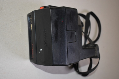
Polaroid Camera, 1980s
... The polaroid camera was first produced in Massachusetts, U.S.A. in 1937 by Edwin Land. ...This is a Polaroid brand instant camera enclosed in a black case. ...Polaroid Sun 660 Autofocus...It features sonar autofocus technology. Polaroid Camera ...The polaroid camera was first produced in Massachusetts, U.S.A. in 1937 by Edwin Land. He developed the concept of instant photography following his production of polarized sunglasses. This Sun 660 model was first produced in 1981. Polaroid cameras were very popular in the 1970s and 80s. The Polaroid Company was re-formed several times and sold to The Impossible Project Company in 2017. Instant cameras can still be purchased today. This camera has no known local provenance but is retained for display purposes.This is a Polaroid brand instant camera enclosed in a black case. It has a cloth strap with plastic attachments. It features sonar autofocus technology.Polaroid Sun 660 Autofocus -
Moorabbin Air Museum
Accessory (Item) - Goggle Flying Kit Type B-8. Specification No.3200 .Polaroid Corporation. (Qty 3X), Goggle Flying Kit Type B-8. Specification No.3200 .Polaroid Corporation
... Specification No.3200 .Polaroid Corporation....Specification No.3200 .Polaroid Corporation. (Qty 3X) ...Stock No.8300-336050 Property Air Forces U.S .Army. -
 Eltham District Historical Society Inc
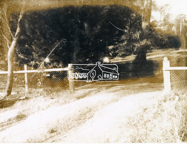
Photograph, 19 Rockcliffe Street (Brougham Street entrance), Eltham, 3:30pm, 5 July 1967, 1967
... Polaroid photograph...Polaroid Manufacturer Code K603831 #7...Public Record Office Victoria, North Melbourne, Victoria.) brougham steet, houses, rockcliffe street, eltham, Ella Dunkel Polaroid Manufacturer Code K603831 #7 Polaroid photograph 19 Rockcliffe Street (Brougham Street entrance), Eltham, 3:30pm, 5 July 1967 Photograph ...Lot 6 L.P. 9499 at eastern most end of Brougham Street Property has since been subdivided and this access end is now 146 Brougham Street Photo taken by Russell Yeoman, Planning Department, Shire of Eltham In the 1954 Electoral Roll Ella Dunkel was listed as living in Diamond Street, Home Duties. In the 1963/1967/1968/1972/1977 electoral rolls she was listed at 19 Rockcliffe Road, Home Duties. Probate was granted 18 July 1979 (Wills and Probate Records. VPRS 28 (Probates) and VPRS 7591 (Wills). Public Record Office Victoria, North Melbourne, Victoria.)Polaroid photographPolaroid Manufacturer Code K603831 #7brougham steet, houses, rockcliffe street, eltham, ella dunkel -
 Eltham District Historical Society Inc
Photograph, 23 Rockcliffe Street (Brougham Street entrance), Eltham, 3:30pm, 5 July 1967, 1967
... Polaroid photograph...Polaroid Manufacturer Code K603831 #6...Eltham District Historical Society Inc 728 Main Rd Eltham melbourne Lot 5 L.P. 9499 at eastern most end of Brougham Street Property has since been subdivided and this access end is now 146 Brougham Street Photo taken by Russell Yeoman, Planning Department, Shire of Eltham brougham steet, houses, rockcliffe street, eltham Polaroid Manufacturer Code K603831 #6 Polaroid photograph 23 Rockcliffe Street (Brougham Street entrance), Eltham, 3:30pm, 5 July 1967 Photograph ...Lot 5 L.P. 9499 at eastern most end of Brougham Street Property has since been subdivided and this access end is now 146 Brougham Street Photo taken by Russell Yeoman, Planning Department, Shire of Eltham Polaroid photographPolaroid Manufacturer Code K603831 #6brougham steet, houses, rockcliffe street, eltham -
 Bendigo Historical Society Inc.
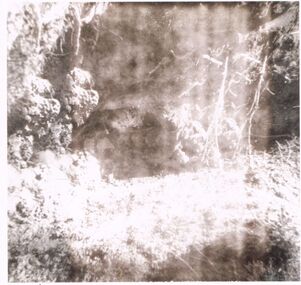
Photograph - CASTLEMAINE GAS COMPANY COLLECTION: PHOTO OF SHRUBS
... Black and white Polaroid photo of some bush shrubs in unknown Location...Polaroid...PHOTOGRAPH Landscape Unknown Polaroid Black and white Polaroid photo of some bush shrubs in unknown Location Photograph CASTLEMAINE GAS COMPANY COLLECTION: PHOTO OF SHRUBS ...Black and white Polaroid photo of some bush shrubs in unknown LocationPolaroidphotograph, landscape, unknown -
 Dandenong/Cranbourne RSL Sub Branch
Clothing - Flying goggles with spare lenses and instruction booklet, Approx 1944
... Polaroid Corporation...Clothing Flying goggles with spare lenses and instruction booklet Polaroid Corporation ...Korean War/Japanese Occupation period historical significanceFlying goggles used by A34219 Stuart Simpson. Also contains lenses used for different flying conditions and instruction booklet. Goggles are with original box.Nil -
University of Melbourne, Burnley Campus Archives
Album - 35mm Colour slides, Forests Commission Victoria, Vic Forests Slides, Unknown
... ...Polaroid...Vic Forests Slides Album 35mm Colour slides Forests Commission Victoria Polaroid ...2 boxes of colour slides labelled "Vic Forests Slides. 1 Box containing handwritten list of labels of slides. Box stamped Jul 31.victoria, forests, arboriculture, victorian forests commission -
 Ballarat Tramway Museum
Photograph - Former Geelong tram 22 - set of 6, c2000
... Set of 5 Polaroid photos of Pengelley built Geelong tram No. 22 at the TMSV Bylands and one photo of a Westinghouse T1F Controller with a note "Controller on all butter boxes and Pengelley Cars" - probably photographed on Ballarat No. 17....Set of 6 Polaroid Colour photographs, with a plain back....Geelong tram 22 tmsv One photo has a notation re controllers. Set of 6 Polaroid Colour photographs, with a plain back. ...Set of 5 Polaroid photos of Pengelley built Geelong tram No. 22 at the TMSV Bylands and one photo of a Westinghouse T1F Controller with a note "Controller on all butter boxes and Pengelley Cars" - probably photographed on Ballarat No. 17.Yields information about Geelong tram 22.Set of 6 Polaroid Colour photographs, with a plain back.One photo has a notation re controllers.geelong, tram 22, tmsv -
 Ithacan Historical Society
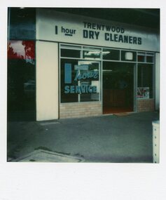
Photograph, Trentwood Dry Cleaners
... A coloured polaroid photograph of the exterior views of a Dry Cleaning business in a suburban street. ...Printed on the back: 10778121539/ POLAROID...Jim learnt the trade from his father-in-law and, together with Leah, carried on the family tradition establishing the dry cleaning business in North Balwyn. pullards dry cleaning Printed on the back: 10778121539/ POLAROID A coloured polaroid photograph of the exterior views of a Dry Cleaning business in a suburban street. ...Dimitri (JIm) and Leah (nee Sikiotis) Kandiliotis ran the Trentwood Dry Cleaning business in Doncaster Road, North Balwyn. Jim was very active in the Ithacan Philanthropic Society; he was president from 1965-1966 and is an Honorary Life Member.Leah's parents Costa and Reene (nee Varvarigos) Sikiotis operated Pullars Dry Cleaning in Rathdowne Street Carlton in the 1950s. Jim learnt the trade from his father-in-law and, together with Leah, carried on the family tradition establishing the dry cleaning business in North Balwyn.A coloured polaroid photograph of the exterior views of a Dry Cleaning business in a suburban street. The photograph has a white border with a black square on its reverse side. Printed on the back: 10778121539/ POLAROIDpullards dry cleaning -
 Eltham District Historical Society Inc
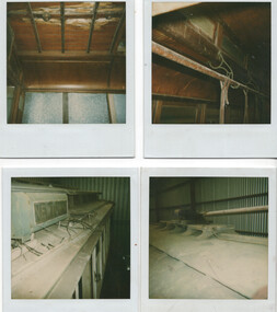
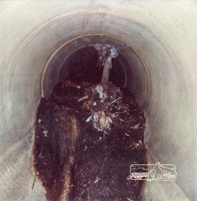
Photograph, Tree roots in stormwater drain, Shire of Eltham, c.1980, 1980c
... ...polaroid...Polaroid R Manufacturer's Batch No. 06031017011 (June 1980)...Eltham District Historical Society Inc 728 Main Rd Eltham melbourne drainage works infrastructure polaroid Polaroid R Manufacturer's Batch No. 06031017011 (June 1980) Colour photograph Tree roots in stormwater drain, Shire of Eltham, c.1980 Photograph ...Colour photographPolaroid R Manufacturer's Batch No. 06031017011 (June 1980)drainage works, infrastructure, polaroid -
 Eltham District Historical Society Inc
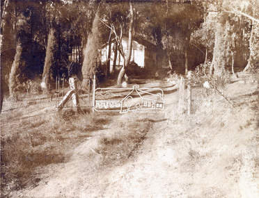
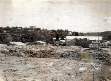
Photograph, Sherbourne Road, Para Road and Simms Road at Briar Hill/Montmorency prior to the upgrade of Sherbourne Road Railway bridge, 3 November 1967, 03/11/1967
... ...polaroid...Polaroid Manufacturer's Batch No. L767302K....Eltham District Historical Society Inc 728 Main Rd Eltham melbourne 1967 briar hill para road polaroid sherbourne road simms road Polaroid Manufacturer's Batch No. ...Sepia photographPolaroid Manufacturer's Batch No. L767302K.1967, briar hill, para road, polaroid, sherbourne road, simms road -
 Eltham District Historical Society Inc
Photograph, Sherbourne Road, Para Road and Simms Road at Briar Hill/Montmorency prior to the upgrade of Sherbourne Road Railway bridge, 3 November 1967, 03/11/1967
... ...polaroid...Polaroid Manufacturer's Batch No. L767302K....Eltham District Historical Society Inc 728 Main Rd Eltham melbourne 1967 briar hill para road polaroid sherbourne road simms road Polaroid Manufacturer's Batch No. ...Sepia photographPolaroid Manufacturer's Batch No. L767302K.1967, briar hill, para road, polaroid, sherbourne road, simms road -
 Whitehorse Historical Society Inc.
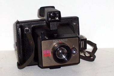
Functional object - Camera, c1975
... Polaroid instantaneous EE44 camera for taking and developing photos instantly. ...Polaroid EE44...Whitehorse Historical Society Inc. 2-10 Deep Creek Road Mitcham melbourne photography cameras Polaroid EE44 Polaroid instantaneous EE44 camera for taking and developing photos instantly. ...Polaroid instantaneous EE44 camera for taking and developing photos instantly. Film pack would be loaded in back of camera. Each photo pack would have its own chemicals within the pack and procedures commenced to print the the photo when its section of the pack was removed from camera. Distance adjustments in both Imperial and Metric. Instructions on back of camera. Provision for flash cube. Developing clip slides into back of camera.Polaroid EE44photography, cameras -
 Eltham District Historical Society Inc
Photograph, Hurstbridge Football Club, Hurstbridge Memorial Park, 50 Graysharps Road, Hurstbridge, 25 September 1983, 25/09/1983
... ...Polaroid...Manufacturer marks: Polaroid 5 Batch #03336047031 (March 1983)....Eltham District Historical Society Inc 728 Main Rd Eltham melbourne hurstbridge Graysharps Road Hurstbridge Football Club Hurstbridge Memorial Park Polaroid Manufacturer marks: Polaroid 5 Batch #03336047031 (March 1983). ...Colour photographManufacturer marks: Polaroid 5 Batch #03336047031 (March 1983).hurstbridge, graysharps road, hurstbridge football club, hurstbridge memorial park, polaroid -
 Eltham District Historical Society Inc
Photograph, Hurstbridge Football Club, Hurstbridge Memorial Park, 50 Graysharps Road, Hurstbridge, 25 September 1983, 25/09/1983
... ...polaroid...Manufacturer marks: Polaroid 5 Batch #03336047031 (March 1983)....Eltham District Historical Society Inc 728 Main Rd Eltham melbourne hurstbridge graysharps road hurstbridge football club hurstbridge memorial park polaroid Manufacturer marks: Polaroid 5 Batch #03336047031 (March 1983). ...Colour photographManufacturer marks: Polaroid 5 Batch #03336047031 (March 1983).hurstbridge, graysharps road, hurstbridge football club, hurstbridge memorial park, polaroid -
 Eltham District Historical Society Inc
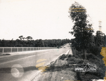
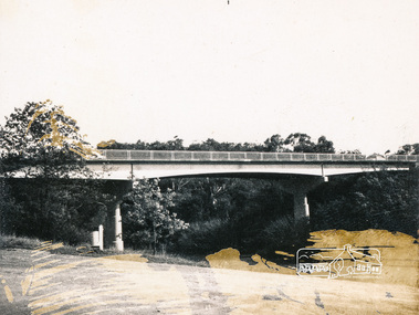
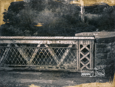
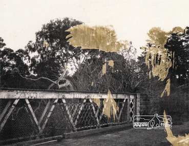
Photograph, Fitzsimons Lane Bridge over Yarra River between Eltham and Templestowe, c.1966, 1966c
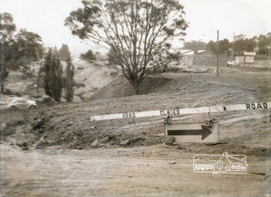
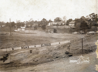
... ...polaroid...Manufacturer's marks: Polaroid, Batch #J62K181 (Sep 1966)....The Diamond Valley News (News clipping held in SEA_74-2_022) infrastructure shire of eltham infrastructure bridge fitzsimons lane bridge polaroid yarra river Manufacturer's marks: Polaroid, Batch #J62K181 (Sep 1966). ...The bridge over the Yarra River was initially opened September 22nd, 1961. Newspaper reports at the time of opening stated it linked Bolton Street, Eltham, with Fitzsimons Lane, Templestowe. In 1955 the Country Roads Board (CRB) produced survey plans that showed proposed land acquisition for the future bridge and road approaches. The 1955 plan shows that it was proposed to connect Fitzsimons Lane with Bolton Street in Eltham by a diagonal road across the river. The road connection would then continue along Bolton Street to Main Road. Prior to construction of the bridge the CRB modified the proposal significantly so that there was a new road parallel with Bolton Street and then curving to join Main Road at what was then its intersection with Old Eltham Road. This involved significantly more land acquisition and altered the pattern of land subdivision through this corridor. Initially the new road was just a single two-way carriageway as it would have required a significant widening of the cutting on the Shire of Eltham side of the river. The road was officially un-named but was known locally as the Eltham-Templestowe Road. The 1966 Melway street directory and other 1960s editions also listed the road as the Eltham-Templestowe Road. In December 1970, Eltham Shire Council, in pursuance of the provisions of the Local Government Act, named it Templestowe Road. The road was renamed Fitzsimons Lane around 1984 in conformity with the section south of the river. In 1991 a new bridge was built to the west of the original bridge. Fitzsimons Lane was widened to four traffic lanes although on the Eltham side this was done within the limits of the existing cutting. NEW BRIDGE STARTS THEM EXPLORING Without any fanfares, Country Roads Board workmen on Friday afternoon put the finishing touches to the approaches, removed the barricades, and let the traffic roll over the new Yarra bridge linking Bolton Street, Eltham, with Fitzsimons Lane, Templestowe. Over the week-end many “bridge watchers” who were making one of their periodic inspections of the progress on the new bridge found to their surprise that they could drive over it, so that people who had gone for a run out to Eltham suddenly found themselves wandering through Templestowe and Doncaster. By Monday the word of the bridge’s opening had got around sufficiently for many regular travellers to the city from Eltham and beyond to vary the monotony by going to town via Templestowe and Kew instead of through Heidelberg. They were surprised at the distances – about 3 ½ miles from Eltham to Templestowe, 6 miles from Eltham Shire hall to the Lower Heidelberg Road-Banksia Street intersection. NEW NEIGHBOURS For people on both sides of the river, the new bridge has turned distant friends into near neighbours. A Greensborough man on Sunday took 35 minutes to reach the home of a friend in East Doncaster, but the return trip over the new bridge took only 17 minutes. It will be some time yet before most people work out the possibilities in shorter and quicker trips form the north-eastern areas to the eastern and south-eastern suburbs. The coming of the warmer months will soon teach many, though the short cuts to Peninsular beaches and eastern suburban drive-ins. And before very long it is likely there will be a Tramways bus running from Templestowe to Eltham station. NEW BRIDGE STARTS THEM EXPLORING (1961, September 27). The Diamond Valley News (News clipping held in SEA_74-1_047) The previously un-named road between Main Road and Yarra River, Eltham South, east of Bolton Street was named Templestowe Road, December 15, 1970 NAMING OF STREETS AND ROADS. (1970, December 15). The Diamond Valley News (News clipping held in SEA_74-2_022)Black and white photographManufacturer's marks: Polaroid, Batch #J62K181 (Sep 1966).infrastructure, shire of eltham infrastructure, bridge, fitzsimons lane bridge, polaroid, yarra river -
 Eltham District Historical Society Inc
Photograph, Fitzsimons Lane Bridge over Yarra River between Eltham and Templestowe, c.1966, 1966c
... ...polaroid...Manufacturer's marks: Polaroid, Batch #J62K181 (Sep 1966)....The Diamond Valley News (News clipping held in SEA_74-2_022) infrastructure shire of eltham infrastructure bridge fitzsimons lane bridge polaroid yarra river Manufacturer's marks: Polaroid, Batch #J62K181 (Sep 1966). ...The bridge over the Yarra River was initially opened September 22nd, 1961. Newspaper reports at the time of opening stated it linked Bolton Street, Eltham, with Fitzsimons Lane, Templestowe. In 1955 the Country Roads Board (CRB) produced survey plans that showed proposed land acquisition for the future bridge and road approaches. The 1955 plan shows that it was proposed to connect Fitzsimons Lane with Bolton Street in Eltham by a diagonal road across the river. The road connection would then continue along Bolton Street to Main Road. Prior to construction of the bridge the CRB modified the proposal significantly so that there was a new road parallel with Bolton Street and then curving to join Main Road at what was then its intersection with Old Eltham Road. This involved significantly more land acquisition and altered the pattern of land subdivision through this corridor. Initially the new road was just a single two-way carriageway as it would have required a significant widening of the cutting on the Shire of Eltham side of the river. The road was officially un-named but was known locally as the Eltham-Templestowe Road. The 1966 Melway street directory and other 1960s editions also listed the road as the Eltham-Templestowe Road. In December 1970, Eltham Shire Council, in pursuance of the provisions of the Local Government Act, named it Templestowe Road. The road was renamed Fitzsimons Lane around 1984 in conformity with the section south of the river. In 1991 a new bridge was built to the west of the original bridge. Fitzsimons Lane was widened to four traffic lanes although on the Eltham side this was done within the limits of the existing cutting. NEW BRIDGE STARTS THEM EXPLORING Without any fanfares, Country Roads Board workmen on Friday afternoon put the finishing touches to the approaches, removed the barricades, and let the traffic roll over the new Yarra bridge linking Bolton Street, Eltham, with Fitzsimons Lane, Templestowe. Over the week-end many “bridge watchers” who were making one of their periodic inspections of the progress on the new bridge found to their surprise that they could drive over it, so that people who had gone for a run out to Eltham suddenly found themselves wandering through Templestowe and Doncaster. By Monday the word of the bridge’s opening had got around sufficiently for many regular travellers to the city from Eltham and beyond to vary the monotony by going to town via Templestowe and Kew instead of through Heidelberg. They were surprised at the distances – about 3 ½ miles from Eltham to Templestowe, 6 miles from Eltham Shire hall to the Lower Heidelberg Road-Banksia Street intersection. NEW NEIGHBOURS For people on both sides of the river, the new bridge has turned distant friends into near neighbours. A Greensborough man on Sunday took 35 minutes to reach the home of a friend in East Doncaster, but the return trip over the new bridge took only 17 minutes. It will be some time yet before most people work out the possibilities in shorter and quicker trips form the north-eastern areas to the eastern and south-eastern suburbs. The coming of the warmer months will soon teach many, though the short cuts to Peninsular beaches and eastern suburban drive-ins. And before very long it is likely there will be a Tramways bus running from Templestowe to Eltham station. NEW BRIDGE STARTS THEM EXPLORING (1961, September 27). The Diamond Valley News (News clipping held in SEA_74-1_047) The previously un-named road between Main Road and Yarra River, Eltham South, east of Bolton Street was named Templestowe Road, December 15, 1970 NAMING OF STREETS AND ROADS. (1970, December 15). The Diamond Valley News (News clipping held in SEA_74-2_022)Black and white photographManufacturer's marks: Polaroid, Batch #J62K181 (Sep 1966).infrastructure, shire of eltham infrastructure, bridge, fitzsimons lane bridge, polaroid, yarra river -
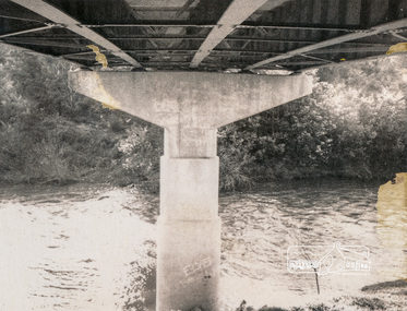
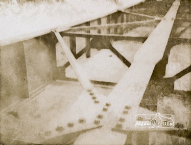
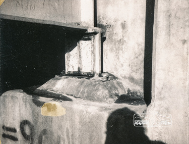
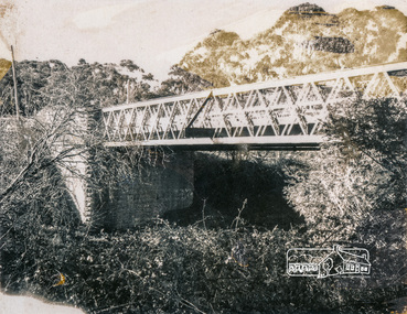 Eltham District Historical Society Inc
Photograph, Old Lower Plenty Bridge, c.1966, 1966c
... ...polaroid...Manufacturer's marks: Polaroid, Batch #J62K181 (Sep. 1966)....Eltham District Historical Society Inc 728 Main Rd Eltham melbourne infrastructure bridge shire of eltham infrastructure lower plenty lower plenty bridge polaroid Manufacturer's marks: Polaroid, Batch #J62K181 (Sep. 1966). ...Black and white photographManufacturer's marks: Polaroid, Batch #J62K181 (Sep. 1966).infrastructure, bridge, shire of eltham infrastructure, lower plenty, lower plenty bridge, polaroid -
 Eltham District Historical Society Inc
Photograph, Sherbourne Road, Para Road and Simms Road at Briar Hill/Montmorency prior to the upgrade of Sherbourne Road Railway bridge, 3 November 1967, 03/11/1967
... ...Polaroid...Noted in pencil on reverse: "3/11/67". Polaroid Manufacturer's Batch No. A730301K....Eltham District Historical Society Inc 728 Main Rd Eltham melbourne 1967 Briar Hill Para Road Polaroid Sherbourne Road Simms Road Noted in pencil on reverse: "3/11/67". ...Sepia photographNoted in pencil on reverse: "3/11/67". Polaroid Manufacturer's Batch No. A730301K.1967, briar hill, para road, polaroid, sherbourne road, simms road -
 Eltham District Historical Society Inc
Photograph, Sherbourne Road, Para Road and Simms Road at Briar Hill/Montmorency prior to the upgrade of Sherbourne Road Railway bridge, 3 November 1967, 03/11/1967
... ...polaroid...Noted in pencil on reverse: "3/11/67". Polaroid Manufacturer's Batch No. A730301K....Eltham District Historical Society Inc 728 Main Rd Eltham melbourne 1967 briar hill para road polaroid sherbourne road simms road Noted in pencil on reverse: "3/11/67". ...Sepia photographNoted in pencil on reverse: "3/11/67". Polaroid Manufacturer's Batch No. A730301K.1967, briar hill, para road, polaroid, sherbourne road, simms road