Showing 7 items matching "polynesia"
-
 Vision Australia
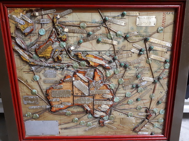
Map - Object, Map of Australia, Polynesia, Melanesia and Malaysia, 1939
... Map of Australia, Polynesia, Melanesia and Malaysia...Tunley 1 paper map with tactile metal markers in red and brown frames Map of Australia, Polynesia, Melanesia and Malaysia Map Object Queensland Braille Map & Model Club ...Tactile map of Australian states and territories, as well as various countries and islands in the South Pacific region, including Papua New Guinea, Indonesia and the Malay peninsula. 1 paper map with tactile metal markers in red and brown framesqueensland braille map and model club, r.f. tunley -
 Phillip Island and District Historical Society Inc.
Book, GILL, William Wyatt, Myths and songs from the South Pacific / by Rev. William Wyatt Gill ; With a preface by F. Max Mu?ller, 1876
... ...polynesia...Phillip Island and District Historical Society Inc. phillip-island-and-the-bass-coast Mythology polynesian mangaia cook islands religion songs polynesia Labelled 'Cowes Municipal Public Library', 'Phillip Island Historical Society, Cleeland Bequest'. ...Labelled 'Cowes Municipal Public Library', 'Phillip Island Historical Society, Cleeland Bequest'.mythology, polynesian, mangaia, cook islands, religion, songs, polynesia -
 Orbost & District Historical Society
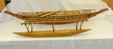
model -outrigger canoe, mid -late 19th century
... Outrigger canoes were originally developed by the peoples of the islands of Southeast Asia for sea travel, and were used to transport these peoples eastward through to Polynesia and New Zealand more than 2000 Years ago. ...Outrigger canoes were originally developed by the peoples of the islands of Southeast Asia for sea travel, and were used to transport these peoples eastward through to Polynesia and New Zealand more than 2000 Years ago. ...The outrigger gives greater stability and seaworthiness to the canoe. Outrigger canoes were originally developed by the peoples of the islands of Southeast Asia for sea travel, and were used to transport these peoples eastward through to Polynesia and New Zealand more than 2000 Years ago. Today they are still in use. This item possibly came to Orbost with Reverend Alexander Morton . Morton was the minister at the Presbyterian church about 1890. He had spent time in new Hebrides and went on to New Zealand.This item is an example of a handcrafted artefact from the New Hebrides.Detailed model of an outrigger canoe from the Polynesian islands. It isa handmade wooden (possibly breadfruit wood) model of an outrigger canoe - one outrigger attached to the main hull. Bound with string. It has two wooden paddles.handcraft morton-alexander model-outrigger-canoe -
 Uniting Church Archives - Synod of Victoria
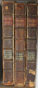
Book - Bible, Henry's bible
... He was appointed to the Hobart Circuit; Chairman of Van Diemen's Land District; General Superintendent of Wesleyan Missions in Australasia and Polynesia. He died in Hobart, Tasmania in March 1942. ...He was appointed to the Hobart Circuit; Chairman of Van Diemen's Land District; General Superintendent of Wesleyan Missions in Australasia and Polynesia. He died in Hobart, Tasmania in March 1942. ...Matthew Henry's Commentary on the Whole Bible (1706) is a six-volume, verse-by-verse exposition of the Old and New Testaments known for its devotional, practical, and scholarly insights. Written by the British Nonconformist minister Matthew Henry (1662–1714). [Source: Wikipedia]Six volumes of brown leather-bound books with gold text on the spines. VOL.1. GEN.DEU Title page: First MDCCLXVII [1767] 7th Edinburgh VOL.2. JOS.EST Title page: Second MDCLXVII 7th Edinburgh VOL.3. JOB.SOLO. Title page: Third MDCLXVII 7th Edinburgh VOL.4. ISA.MALA. Title page: Fourth MDCCLXVII [1767] 7th ed. Edinburgh VOL.5. MAT.JON. Title page: First MDCCLXIX [1769] 7th ed. Edinburgh VOL.6. ACTS.REV. Title page: Second MDCCLXII [1763] 5th ed. London.non-fictionMatthew Henry's Commentary on the Whole Bible (1706) is a six-volume, verse-by-verse exposition of the Old and New Testaments known for its devotional, practical, and scholarly insights. Written by the British Nonconformist minister Matthew Henry (1662–1714). [Source: Wikipedia]rev john waterhouse 1789 - 1842 -
 Lara RSL Sub Branch
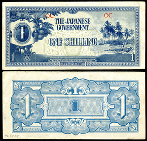
Money, Japanese Goverment One Shilling, 1942
... Geographically, the region of Oceania comprises numerous islands across the vast South and Central Pacific which includes the islands of New Zealand.[1] Certain descriptions may or may not include Australia.[2] Oceania has also been defined by island groupings: Melanesia, Micronesia, and Polynesia.[1][3] However, from a numismatic perspective (i.e., the issuance of Japanese invasion money), Oceania consisted of the occupied territories of Guam, Gilbert and Ellice Islands, Caroline Islands, Marianas Islands, Solomon Islands, Palau, and the now defunct Territory of New Guinea.[4] [5] Although officially called "Oceania" the region was considered a financial and currency union under Japanese colonial dominion that included several political jurisdictions rather than a single polity....Geographically, the region of Oceania comprises numerous islands across the vast South and Central Pacific which includes the islands of New Zealand.[1] Certain descriptions may or may not include Australia.[2] Oceania has also been defined by island groupings: Melanesia, Micronesia, and Polynesia.[1][3] However, from a numismatic perspective (i.e., the issuance of Japanese invasion money), Oceania consisted of the occupied territories of Guam, Gilbert and Ellice Islands, Caroline Islands, Marianas Islands, Solomon Islands, Palau, and the now defunct Territory of New Guinea.[4] [5] Although officially called "Oceania" the region was considered a financial and currency union under Japanese colonial dominion that included several political jurisdictions rather than a single polity. money, paper, currency, japanese, wwii, japan, oceania, shilling, one, occupation, japanese government, blue On the front reads "Japanese Government One Shilling" and on the reverse the number 1. ...The Japanese government-issued Oceanian Pound was one of several issues of Japanese invasion money used during World War II. Consisting of only four denominations, the Oceanian Pound was the shortest set (i.e., total number of denominations) issued. Geographically, the region of Oceania comprises numerous islands across the vast South and Central Pacific which includes the islands of New Zealand.[1] Certain descriptions may or may not include Australia.[2] Oceania has also been defined by island groupings: Melanesia, Micronesia, and Polynesia.[1][3] However, from a numismatic perspective (i.e., the issuance of Japanese invasion money), Oceania consisted of the occupied territories of Guam, Gilbert and Ellice Islands, Caroline Islands, Marianas Islands, Solomon Islands, Palau, and the now defunct Territory of New Guinea.[4] [5] Although officially called "Oceania" the region was considered a financial and currency union under Japanese colonial dominion that included several political jurisdictions rather than a single polity.A blue coloured paper note with picture of fruit and an island beach on the front.On the front reads "Japanese Government One Shilling" and on the reverse the number 1. On the front in red are the letters "OC".money, paper, currency, japanese, wwii, japan, oceania, shilling, one, occupation, japanese government, blue -
 Alfred Hospital Nurses League - Nursing History Collection
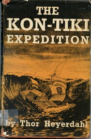
Book - Illustrated book, Thor Heyerdahl 1914-2002 et al, The Kon-Tiki expedition: by raft across the South Seas
... Thor Heyerdahl Kon-Tiki Expedition Ethnology-Polynesia AHNL The story of a daring voyage by the author and five companions on board a primitive raft from the coast of Peru to the Pacific Islands. ...The story of a daring voyage by the author and five companions on board a primitive raft from the coast of Peru to the Pacific Islands. Mr. Heyerdahl was convinced that the original Polynesians had come by sea from South America, and to prove that such a voyage was possible at that remote period, he and his party built the 'Kon-Tiki', similar to the rafts then used and embarked on it. After a voyage full of danger, but packed with interest they reached the islands where the Kon-Tiki was wrecked on a coral reef.Illustrated book with dustjacket. Book is bound in front cover, with image of a Polynesian mask embossed on the front. Title, author's and publisher's names are stamped in gilt on spine. Front cover of dustjacket has a black and light brown illustration of a raft at sea, along with title and author's name printed in white. The spine has similar information plus publisher's name in light brown print along with another illustration of a raft and a Polynesian mask. The back of the dust jacket (again in black and light brown) is a route map and labeled diagram of a raft (the Kon-Tiki). non-fictionThe story of a daring voyage by the author and five companions on board a primitive raft from the coast of Peru to the Pacific Islands. Mr. Heyerdahl was convinced that the original Polynesians had come by sea from South America, and to prove that such a voyage was possible at that remote period, he and his party built the 'Kon-Tiki', similar to the rafts then used and embarked on it. After a voyage full of danger, but packed with interest they reached the islands where the Kon-Tiki was wrecked on a coral reef.thor heyerdahl, kon-tiki expedition, ethnology-polynesia, ahnl -
 The Foundling Archive
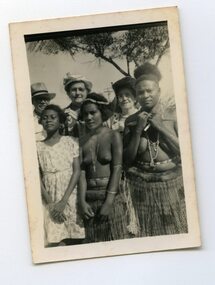
Photograph
... West Sydney; Australia; Melanesia; Polynesia; holiday; Barney Grimes, Mum, Mary Grimes This photograph is part of the West Sydney Collection which depicts the period around Second World War in Australia from the perspective of a young unknown woman. ...This photograph is part of the West Sydney Collection which depicts the period around Second World War in Australia from the perspective of a young unknown woman.This photograph is part of the West Sydney Collection which depicts the period around Second World War in Australia from the perspective of a young unknown woman.Barney Grimes, Mum, Mary Grimeswest sydney; australia; melanesia; polynesia; holiday;