Showing 46 items matching "position lines"
-
 Moorabbin Air Museum
Book - Aerial navigation, Air Navigation
... ...Position lines...Aerial navigation Mathematics Maps & charts Time The theory of D.R. navigation Position lines Astronomical navigation Magnetism & compasses Direction finding wireless Tactical navigation Ground organization Applied air navigation Training text for air navigators circa 1941 Air Navigation Book Aerial navigation ...Training text for air navigators circa 1941non-fictionTraining text for air navigators circa 1941mathematics, maps & charts, time, the theory of d.r. navigation, position lines, astronomical navigation, magnetism & compasses, direction finding wireless, tactical navigation, ground organization, applied air navigation -
Moorabbin Air Museum
Book - Navigation, The Observer's Book on Dead Reckoning Navigation
... ...Position lines...Moorabbin Air Museum Moorabbin Airport 12 First Street Moorabbin melbourne Navigation General remarks Position lines Air plotting Relative velocity Radius of action Overview of all forms of dead reckoning navigation, circa 1940 The Observer's Book on Dead Reckoning Navigation Book Navigation ...Overview of all forms of dead reckoning navigation, circa 1940non-fictionOverview of all forms of dead reckoning navigation, circa 1940general remarks, position lines, air plotting, relative velocity, radius of action -
Moorabbin Air Museum
Book - Navigation, The ABC of Practical Astro-Navigation
... Position lines...Moorabbin Air Museum Moorabbin Airport 12 First Street Moorabbin melbourne Navigation Position lines Practical aero navigation Questions & answers Exercises Text/exercise book on aerial navigation, circa 1946 The ABC of Practical Astro-Navigation Book Navigation ...Text/exercise book on aerial navigation, circa 1946non-fictionText/exercise book on aerial navigation, circa 1946position lines, practical aero navigation, questions & answers, exercises -
Moorabbin Air Museum
Manual (Item) - US Navy Air Navigation Training Course Part 3, Dead Reckoning, Air Navigation - Part Three: Dead Reckoning and Lines of Position
... Air Navigation - Part Three: Dead Reckoning and Lines of Position...Moorabbin Air Museum Moorabbin Airport 12 First Street Moorabbin melbourne Brown soft-cover manual with illustration of plane and globe on the front Air Navigation - Part Three: Dead Reckoning and Lines of Position Manual US Navy Air Navigation Training Course Part 3, Dead Reckoning ... -
 Hume City Civic Collection
Photograph, 21/04/2005
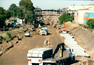
... On the tracks the old railway lines have been removed and storm water pipes are being put into position before the new lines are to be laid....On the tracks the old railway lines have been removed and storm water pipes are being put into position before the new lines are to be laid. ...This photograph was taken during the upgrade of the Bendigo Railway line at Sunbury Station. The upgrade took twelve months to complete and during that time bus services replaced the trains.A coloured photograph of construction on the site of the Sunbury Railway Station. The photograph has been taken from the Macedon Street bridge looking south towards the station and the pedestrian bridge over the railway tracks. On the tracks the old railway lines have been removed and storm water pipes are being put into position before the new lines are to be laid.railways, bendigo line, railway stations, bridges, sunbury railway station, george evans collection -
Moorabbin Air Museum
Instrument (Item) - W&G "Douglas" Combined Protractor And Parallel Rule
... lines .It consists of a centimetre ruler and angle bearing markings around the perimeter, a central compass, with four points and a 0.20cm marking, set out on an 8 x 8 square grid. The protractor is housed in a double sided, green, printed square card sleeve. The front of the sleeve features a description of the product and a series of warnings on usage, while the back displays instructions and examples of the various uses of the parallel rule including laying off a course bearing, finding departure or latitude, find a magnetic course or bearing from true, fixing positions by angles and plotting lines of position....lines .It consists of a centimetre ruler and angle bearing markings around the perimeter, a central compass, with four points and a 0.20cm marking, set out on an 8 x 8 square grid. The protractor is housed in a double sided, green, printed square card sleeve. The front of the sleeve features a description of the product and a series of warnings on usage, while the back displays instructions and examples of the various uses of the parallel rule including laying off a course bearing, finding departure or latitude, find a magnetic course or bearing from true, fixing positions by angles and plotting lines of position. ... -
 Warrnambool and District Historical Society Inc.
Buttons, Australian Military Buttons, Early 20th Century
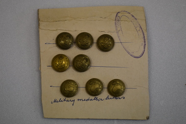
... Five buttons have AUSTRALIAN COMMONWEALTH FORCES Military medallion buttons ( hand written) Stamp is oval shaped with faded text of which only HISTORICAL DISTRICT and SOCIETY can be deciphered Three blue hand drawn lines to position the buttons. ...Five buttons have AUSTRALIAN COMMONWEALTH FORCES Military medallion buttons ( hand written) Stamp is oval shaped with faded text of which only HISTORICAL DISTRICT and SOCIETY can be deciphered Three blue hand drawn lines to position the buttons. Seven brass circular military buttons pressed into a rectangular piece of cardboard with pasted on lined paper on the back of the cardboard. ...The Australian Military Forces buttons were worn by Australian troops in World Wars One and Two. The Australian Commonwealth buttons date from the Edwardian era (1901-1910)These buttons are examples of the buttons used by the Australian Army. The attachment to a card is also an interesting example of the way members of the Warrnambool and District Historical Society mounted and displayed collection items in the 1960's and 1970's.Seven brass circular military buttons pressed into a rectangular piece of cardboard with pasted on lined paper on the back of the cardboard. Three of the buttons feature a raised map of Australia, a crown and text. Five buttons feature a raised intertwined E R,V11, a crown and text Protruding through the paper at the back is a section of a ring. The cardboard side has hand drawn blue lines, an oval stamp with text and hand written text. Three buttons have AUSTRALIAN MILITARY FORCES. Five buttons have AUSTRALIAN COMMONWEALTH FORCES Military medallion buttons ( hand written) Stamp is oval shaped with faded text of which only HISTORICAL DISTRICT and SOCIETY can be deciphered Three blue hand drawn lines to position the buttons. army, australian military forces, buttons, world war two, world war one -
 Bendigo Military Museum
Map - BATTLE MAP - SYDNEY EMDEN, Possibly 1928
... lines throughout the drawing - possibly indicating when shots were exchanged. It shows a list in the centre, showing basic specs of the two warships and their battle casualties. It also shows relative positions...lines throughout the drawing - possibly indicating when shots were exchanged. It shows a list in the centre, showing basic specs of the two warships and their battle casualties. It also shows relative positions ...This is a medium size poster. It is drawn in black ink. It shows an image of HMAS SYDNEY, SS BURESK (Collier) and SMS EMDEN. It shows the tracks the two ships took through the battle. It shows dotting lines throughout the drawing - possibly indicating when shots were exchanged. It shows a list in the centre, showing basic specs of the two warships and their battle casualties. It also shows relative positions of Keeling Island and Direction Island.ww1, sms emden, hmas sydney -
 Bendigo Military Museum
Newspaper - NEWSPAPER EXTRACTS
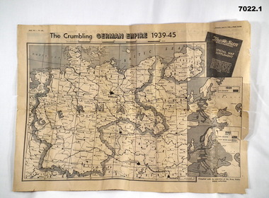
... The various map extract showed the position of the German Control of Europe at the point of time in 1944 and April 1945 near the end. Was for general issue at a time when Allied Forces were on top moving towards German lines....Bendigo Military Museum 37 - 39 Pall Mall Bendigo goldfields The various map extract showed the position of the German Control of Europe at the point of time in 1944 and April 1945 near the end. Was for general issue at a time when Allied Forces were on top moving towards German lines. ...The various map extract showed the position of the German Control of Europe at the point of time in 1944 and April 1945 near the end. Was for general issue at a time when Allied Forces were on top moving towards German lines.Yellow faded paper, black writing and b & W photos. 1. Four page extract from Newspaper "The Sun" with centre pages having a detailed map of the European Theatre of War dated 11 April 1945. front and Back pages covering normal news items. 2. Four page extract from "The Sun" newspaper giving a phasing of German control of Europe over period of War and a detailed map of position as at 5th August 1944. Final page lists key dates in the history of the War.1. Map headed "The Crumbling German Empire 1939-45". 2. Maps headed "The War Map".ww2, europe, maps, newspapers -
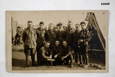 Bendigo Military Museum
Postcard - POSTCARD, PHOTOGRAPHIC - GROUP PORTRAIT, Australian Army, 1914-1918
... In the tent lines, in the background, another officer can be seen talking to someone in a tent. The soldier on the right is holding a set of bagpipes in the " ready" position. ...In the tent lines, in the background, another officer can be seen talking to someone in a tent. The soldier on the right is holding a set of bagpipes in the " ready" position. ...This is a black and white group portrait of ten Australian soldiers. They are in tent lines. They are in uniform, casually dressed with only one soldier wearing a hat, that is the neat and tidy young officer in centre rear, A Lewis MMG is on its bipod on the ground in front of this group. In the tent lines, in the background, another officer can be seen talking to someone in a tent. The soldier on the right is holding a set of bagpipes in the " ready" position. The unit of the soldiers has a vertical rectangular colour patch.Faintly on the rear side can be seen the name " Gath".ww1, lewis gun -
4th/19th Prince of Wales's Light Horse Regiment Unit History Room
Tripod, Bren Light Machine Gun
... Used for setting up in defensive position for firing on fixed lines...4th/19th Prince of Wales's Light Horse Regiment Unit History Room 4/19 PWLH Regiment, Building 78 Simpson Barracks Macleod melbourne Used for setting up in defensive position for firing on fixed lines The 4/19 PWLH Regiment was previously equipped with Bren guns. ...Used for setting up in defensive position for firing on fixed linesThe 4/19 PWLH Regiment was previously equipped with Bren guns. However being a mounted unit, Bren LMG were either carried as personal weapons of the unit's assault troopers or mounted on Mk1 Ferret Scout Cars or Saracen Armoured Personnel Carriers. As far as is known, this tripod was not on issue.weapons, mounts, bren gun, tripod -
 Kiewa Valley Historical Society
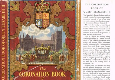
Book - History, The Coronation Book of Queen Elizabeth II, Circa 1952
... positioned, large photograph of the Queen. The respect for British royalty was quite pronounced by the royal toast, offered before "official" proceedings commenced, and in the military flying the royal "blessed" colours. This book was donated by one of the founding families residing in the Kiewa Valley and is typical of the general feeling of respect and admiration felt by the rural communities towards the British Royal Family, especially towards Queen Elizabeth II. The rural slant towards any form of patriotism was along the lines ...This book was produced in a period of time when Australians, especially those in rural areas referred to Britain as "the mother" country. It was a time when the transition from a colonial dominion of Britain to the status of an individual State through the Australian Constitution was quite apparent, except for the affection and respect of the majority of the population towards "their" Queen. It was a time when the Governor General (Queen's representative) were British born and picked. Australia had grown from a colonial status to an individual state. The feeling towards the monarchy is aptly demonstrated by the words from the High Commissioner for Australia, Sir Thomas White K.B.E., proposal for Australia to adopt the royal title "Elizabeth the Second by the grace of God of the United Kingdom, Australia and her realms and territories Queen, Head of the Commonwealth, defender of the Faith" Here faith implies the christian (Church of England) religion. In rural Australia the respect and admiration for the Queen was very high and all public offices, clubs and halls displayed a well positioned, large photograph of the Queen. The respect for British royalty was quite pronounced by the royal toast, offered before "official" proceedings commenced, and in the military flying the royal "blessed" colours.This book was donated by one of the founding families residing in the Kiewa Valley and is typical of the general feeling of respect and admiration felt by the rural communities towards the British Royal Family, especially towards Queen Elizabeth II. The rural slant towards any form of patriotism was along the lines of "Queen and Country", in that order. After World War II the social texture through multi-culturalism (especially in the Cities)moved away from this "motherland" bondage but it had taken a longer period to penetrate those rural sectors within the Kiewa valley and high plains areas. The great post World War II immigration of European refugees started a shift of numbers of Australian families whose parents were not born in Australia or had British family ties. The book represents a period in time where ties to Britain where a lot strong and entrenched in the social fabric of the Australian rural sector. The growing push for a republic is becoming stronger and stronger as the level of rural royalists deminishes.This item is a hard covered book of 200 pages including 8 pages in full colour and over 250 photographs covering the British royal family and in particular Queen Elizabeth II and her coronation. The external protective paper dust-jacket is in colour. Specific references to Australia appear on pages 9,36 to 41 and 97. The hard cover has a "off" white cloth textured (glued reinforced) cover over thick cardboard . The front and back pages depict the Royal investiture carriage with guards and footmen. Little cherubs are portrayed around the sheath holding the Royal Crown. Crowned lion and stallion sit at attention on either side of the carriage, with the Royal shield supporting their front legs.,The dust jacket is in full colour with the wording "The CORONATION BOOK of QUEEN ELIZABETH II" With a Pictorial Record of the Ceremony" The spin of the jacket (in gold print on a regal red background) "THE CORONATION BOOK OF QUEEN ELIZABETH II" on the bottom "ODHAMS" The cover has a pressed oval shaped double lined border enclosing a crown and the words Elizabeth R, below which is pressed 1953. The spine has the following words in gold coloured print "THE CORONATION BOOK OF QUEEN ELIZABETH II. The front, inside flap, of the dust jacket details the significance of what is contained within the book and the back inside flap has the contents and those personages who contributed. The back of the dust jacket has a brief review of three other books covering other aspects of British royalty and they are titled "THE DUKE OF EDINBURGH" ( a pictorial biography), "QUEEN MARY" (her life and times) and "ROYAL HOMES ILLUSTRATED" (with an essay on the royal palaces by A.L. Rowse.modern australian history, british royalty, queen elizabeth ii, coronation of queen elizabeth ii, australia's "mother country" -
 The Beechworth Burke Museum
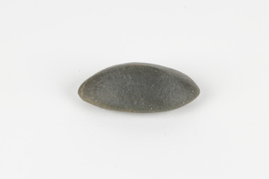
Geological specimen - Ventifact (wind- or ice-shaped) pebble
... positions. This specimen was among those donated to the Burke Museum in 1868. burke museum beechworth geological geological specimen ventifact antarctic region antarctic Alfred Richard Cecil Selwyn Alfred Selwyn wind direction wind strength abraders wind flow climate change reconstruction of wind flow conditions weather change Mars light lines visible in all configurations and a groove on configuration 2 A hand-sized solid mineral specimen in shades of dark and light browns with light lines visible in all configurations and a groove on configuration 2. ...Ventifacts are sand-blasted rocks that are typically faceted and often display parallel grooves carved by wind-blown sand. They are useful indicators of wind direction and strength in environments such as deserts, mountains, and coastal areas because they are usually not hidden by later sediment, soil or vegetation cover. In Antarctica ventifaction is strongly related to the composition or type of rock. Ventifacts are important because they provide evidence for abraders such as sand, dust or snow and ice crystals, and offer a unique understanding of past wind processes that are effective in the reconstruction of past wind flow conditions and can provides clues to weather and climate changes in the past. Interestingly ventifacts have also been found on the surface of Mars. They were a threat to the NASA rover due to the sharp angles of the facets, created by the Martian wind over the course of millions of years. These Martian ventifacts act like weathervanes for past wind and weather patterns on the red planet in a similar manner to those found on earth.The Geological Survey of Victoria was instigated in response to the Victorian Gold Rush which began around 1851 in the Beechworth, Castlemaine, Daylesford, Bendigo and Ballarat areas. The survey was conducted by Alfred Richard Cecil Selwyn from his arrival in December 1852 until his resignation in 1869and during this time he trained many notable geologists, e.g. Aplin, Wilkinson, Daintree, who went on to other State survey senior positions. This specimen was among those donated to the Burke Museum in 1868.A hand-sized solid mineral specimen in shades of dark and light browns with light lines visible in all configurations and a groove on configuration 2.light lines visible in all configurations and a groove on configuration 2burke museum, beechworth, geological, geological specimen, ventifact, antarctic region, antarctic, alfred richard cecil selwyn, alfred selwyn, wind direction, wind strength, abraders, wind flow, climate change, reconstruction of wind flow conditions, weather change, mars -
 Heidelberg Repatriation Hospital
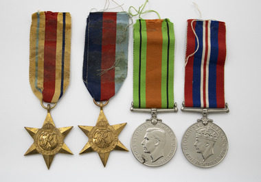
Medal - Set of medals, c. 1945
... lines. "ECRP" near the rim at the nine o'clock position...lines. "ECRP" near the rim at the nine o'clock position Four medals with ribbons. ...HUTCHINS, Mervyn Arthur Thomas VX27912 Born in Mornington, Victoria, October 1906, Mervyn joined the Australian Armed Forces in Caulfield in June 1940. Mervyn was posted with the 2/23rd Battalion and was sent to Tobruk. He died at Heidelberg Repatriation Hospital in the 1970's.Mervyn Thomas was a patient at Heidelberg Repatriation Hospital Four medals with ribbons. Star (.1), Star (.2), Silver (.3), Silver (.4) awarded to Mervyn Hutchins56.1 Front Crown Emblem. GRJ / VI / The 1939 - 1945 STAR 5.1 Back VX27912 M.A.T. HUTCHINS 56.2 Front Crown Emblem. GRJ / VI / The AFRICA STAR Back VX27912 M.A.T. HUTCHINS 56.3 Bare head effigy King George VI facing left. GEORGIVS VI D:G:BR:OMN:REX F:D:IND:IMP. Back shows the Royal Crown resting on an oak sapling, flanked by a lion and a lioness above waves. At the top left is the year "1939" and at the top right the year "1945". The exergue has the words "THE DEFENCE MEDAL" in two lines. 56.4 Front crowned effigy of King George VI, facing left and signed "PM" below neck. Around the perimeter is the legend "GEORGIVS VI D:G:BR:OMN:REX ET INDIAE IMP:" Back The reverse shows a lion standing wanton on the body of a double-headed dragon. Top right are the years "1939" and "1945" in two lines. "ECRP" near the rim at the nine o'clock positionmervyn hutchins collection, rats of tobruk, heidelberg repatriation hospital, caulfield, 2/23rd battalion, vx27912, 1939-1945 star, star of africa, defence medal, war medal, wwii -
 Mission to Seafarers Victoria
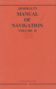
Book, Her Majesty's Stationery Office, Admiralty Manual of Navigation Vol.2, 1973
... The first chapters are mainly concerned with distances, courses, tracks and charts; then various methods of obtaining position lines and positions from astronomical observations are explained, including a rapid. method in the last chapter. ...This volume of the Admiralty Manual of Navigation describes off-shore navigation - the safe conduct of a ship across the open sea where, in general, hearings of objects on land cannot be obtained except by means of radio waves (i.e. using radio fixing aids). The first chapters are mainly concerned with distances, courses, tracks and charts; then various methods of obtaining position lines and positions from astronomical observations are explained, including a rapid. method in the last chapter. The volume also contains an outline of meteorrology and weather forecasting.329 pages, illustrated, navy blue linen cover and red paper dust jacket.non-fictionThis volume of the Admiralty Manual of Navigation describes off-shore navigation - the safe conduct of a ship across the open sea where, in general, hearings of objects on land cannot be obtained except by means of radio waves (i.e. using radio fixing aids). The first chapters are mainly concerned with distances, courses, tracks and charts; then various methods of obtaining position lines and positions from astronomical observations are explained, including a rapid. method in the last chapter. The volume also contains an outline of meteorrology and weather forecasting.howard timbury, first fleet fellowship victoria, interest group, navigation, education -
 Bendigo Historical Society Inc.
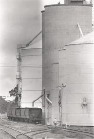
Photograph - PHOTOGRAPH. ELMORE SILOS, 1993
... Six railway trucks positioned ready to be filled. Man walking between lines toward silos and trucks....Six railway trucks positioned ready to be filled. Man walking between lines toward silos and trucks. ...Photograph. Elmore silos next to railway line. Six railway trucks positioned ready to be filled. Man walking between lines toward silos and trucks.elmore, silos, agricultural -
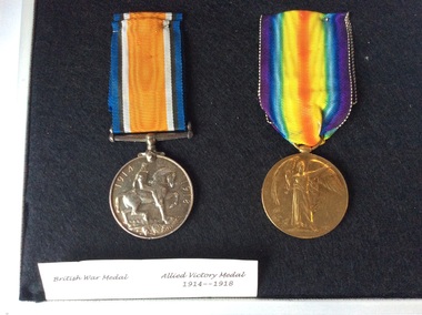 Kyneton RSL Sub Branch
WW1 Medals
... positions near the Aubers Ridge in French Flanders. The attack was intended as a feint to hold German reserves from moving south to the Somme where a large Allied offensive had begun on 1 July. The feint was a disastrous failure. Australian and British soldiers assaulted over open ground in broad daylight and under direct observation and heavy fire from the German lines ...Pte Simmons was born in Kyneton. Died at the battle of Fromelles, July 1916.Fromelles. The battle of Fromelles on 19 July 1916 was a bloody initiation for Australian soldiers to warfare on the Western Front. Soldiers of the newly arrived 5th Australian Division, together with the British 61st Division, were ordered to attack strongly fortified German front line positions near the Aubers Ridge in French Flanders. The attack was intended as a feint to hold German reserves from moving south to the Somme where a large Allied offensive had begun on 1 July. The feint was a disastrous failure. Australian and British soldiers assaulted over open ground in broad daylight and under direct observation and heavy fire from the German lines. Over 5,500 Australians became casualties. Almost 2,000 of them were killed in action or died of wounds and some 400 were captured. This is believed to be the greatest loss by a single division in 24 hours during the entire First World War. Some consider Fromelles the most tragic event in Australia’s history. www.awm.gov.au/articles/encyclopedia/fromelles Two WW1 War service medals with ribbons in a white presentation case. With black clothe lining. On the rim of each medal is: 4899Pte N T Simmons 59 Bn AIF The medals are labelled British War Medal and Allied Victory Medal 1914- 1918. On the inside of the lid is card inscribed: Posthumus award to 4899 Pte N T Simmons 59 Bn AIF. ww1 medals, british war medal, allied victory medal 1914- 1918, n t simmons, fromelles -
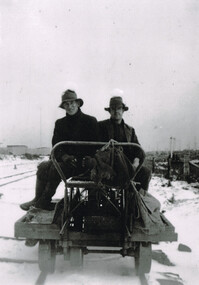 Otway Districts Historical Society
Photograph, Woosnan, Frank, Track gang at Beech Forest, c.1940, c.1940
... lines that the trains ran over. Gangers (the men in charge of the track gangs) tended to be promoted into the Otways but many of their subordinate repairers were local recruits. A few of the men who worked on the original construction gangs of 1900-02 remained and obtained positions in the track gangs along the line, but these eased out over time. ...lines that the trains ran over. Gangers (the men in charge of the track gangs) tended to be promoted into the Otways but many of their subordinate repairers were local recruits. A few of the men who worked on the original construction gangs of 1900-02 remained and obtained positions in the track gangs along the line, but these eased out over time. ...At its peak the Colac-Beech Forest-Crowes railway employed more than 21 staff tending the lines that the trains ran over. Gangers (the men in charge of the track gangs) tended to be promoted into the Otways but many of their subordinate repairers were local recruits. A few of the men who worked on the original construction gangs of 1900-02 remained and obtained positions in the track gangs along the line, but these eased out over time. The track was maintained by seven three-man gangs based at Colac, Barongarook, Gellibrand, Banool, Beech Forest (where the second Beech Forest crew was based at Wyelangta), and Lavers Hill.Track gang on an NK wagon at Beech Forest, c.1940. Snow covers the ground. B/W.colac; beech forest; crowes; railway; track gangs; -
 Bendigo Historical Society Inc.
Document - MARKS COLLECTION: ABE LINCOLN CO LEASE
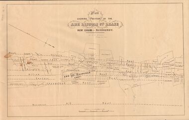
... Position of the Abe Lincoln Co. Lease, New Chum, Sandhurst' under name 'by H.B. Nicholas, Mining Surveyor' Sheepshead Reef, Easter reef, Alfred Reef, Allingham Reef,Adventure Reef, Belle Vue Reef, New Chum Reef, Black Lead, Victoria Reef lines shown on map with mine leases marked. ...Position of the Abe Lincoln Co. Lease, New Chum, Sandhurst' under name 'by H.B. Nicholas, Mining Surveyor' Sheepshead Reef, Easter reef, Alfred Reef, Allingham Reef,Adventure Reef, Belle Vue Reef, New Chum Reef, Black Lead, Victoria Reef lines shown on map with mine leases marked. ...Two copies of plan for Abe Lincoln Co. Lease, New Chum, Sandhurst. One original, one copy. On top of plan 'Plan Showing Position of the Abe Lincoln Co. Lease, New Chum, Sandhurst' under name 'by H.B. Nicholas, Mining Surveyor' Sheepshead Reef, Easter reef, Alfred Reef, Allingham Reef,Adventure Reef, Belle Vue Reef, New Chum Reef, Black Lead, Victoria Reef lines shown on map with mine leases marked. On bottom of map 'Monument Hill Reef' line marked.bendigo, mining, abe lincoln lease -
 Bendigo Historical Society Inc.
Document - MCCOLL, RANKIN AND STANISTREET COLLECTION: SUNDRY REPORTS, 1930's
... Map with lines of reef showing the position of the New Moon Consolidated and the New Moon United shafts.; 14, Large scale map from Harrison/Victoria street to Havilah Road showing the positions of the Carlisle, North Garden and Unity Shafts....Map with lines of reef showing the position of the New Moon Consolidated and the New Moon United shafts.; 14, Large scale map from Harrison/Victoria street to Havilah Road showing the positions of the Carlisle, North Garden and Unity Shafts. ...Manilla Folder containing reports from various mines in Bendigo and surrounding areas. 1. 4 page typewritten report on the Balaclava Hill Mine at Rushworth and some newspaper clippings about the mine with a plan of the underground workings; 2. Page from the Árgus' dated 2nd August 1900 featuring an article on the survey of the Garden line of Reefs; 3. 5 page report with maps on the Tooleen Gold Field; 4. Single page report about an unnamed mining area claimed to be on the southern end of the Deborah line of reef. (this could be the 'Three Jays' mine in Sedgwick. P. Wilkin); 5. Hand written report on the Coronation Mine, 2 miles east of Walhalla.; 6. Hand written report dated 1935, of the Queen Mary mine, St. Arnaud.; 7. 1932 report on the North Neangar lease.; 8 4 page report on the Kings Prize Gold Mining Syndicate.; 9. Description of the plant of the Marong Alluvial Company? Also a guide for marking out leases.; 10. Crushing details (1 page) from the 'Enterprise' Mine South of and adjacent to Perseverence.; 11. 1 page crushing details from Rowe Brothers, Mosquito Mine, Fryerstown.; 12 hand written report mentions Arthur Hatfield, Scarsdale.; 13. Map with lines of reef showing the position of the New Moon Consolidated and the New Moon United shafts.; 14, Large scale map from Harrison/Victoria street to Havilah Road showing the positions of the Carlisle, North Garden and Unity Shafts.gold mining, miners' safety cage, sundry reports, mining. bendigo, rushworth, balaclava hill, garden line of reef, toolleen, coronation mine, walhalla, queen mary mine, st. arnaud. north neangar, kings prize gold mining syndicate, marong, enterprise mine, perseverence, rowe brothers, mosquito mine, fryerstown, arthur hatfield, scarsdale, new moon consolidate, new moon united, carlisle, north garden, unity. -
 Bendigo Historical Society Inc.
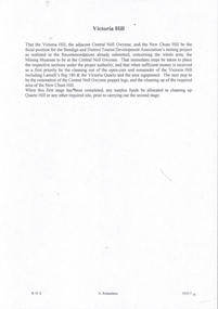
Document - NEW CHUM & VICTORIA LINES OF REEF - NOTES ON VICTORIA HILL FOR TOURIST ATTRACTION
... History House 11 Mackenzie Street Bendigo goldfields DOCUMENT Gold New Chum & Victoria Lines of Reef Central Nell Gwynne New Chum Hill Bendigo and District Tourist Development Association Victoria Hill Lansell's Big 180 Victoria Quartz Rae's Open Cut Handwritten notes outlining a plan for Victoria Hill, Central Nell Gwynne and New Chum Hill to be the focal position for a tourist attraction. ...Handwritten notes outlining a plan for Victoria Hill, Central Nell Gwynne and New Chum Hill to be the focal position for a tourist attraction. Outlines steps to be taken to do the work and a mining museum at the Central Nell Gwynne. On the back of the page is a sketch of Victoria & New Chum Hills. On the plan is the Battery, Rae, Rae's House, Rae's Open Cut, Wittscheibe, Midway, Victoria Quartz, Lansell's 180 Shaft and the Recreation Reserve.document, gold, new chum & victoria lines of reef, central nell gwynne, new chum hill, bendigo and district tourist development association, victoria hill, lansell's big 180, victoria quartz, rae's open cut -
 Ringwood and District Historical Society
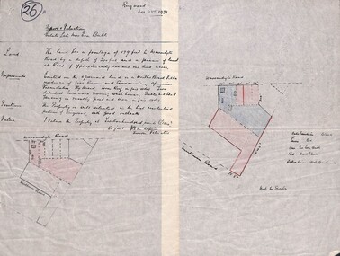
Document, Subdivision Property Report and Valuation - Estate of late Mrs Eva Bull, Warrandyte Road, Ringwood - 1931
... lines for fences, blue shading marked for Estate of Eva Bull, and red shading for David G. Bull. Diagram not to scale. Value comment: "I value the property at twelve hundred pounds (£1200) Signed J.B. McAlpin, Sworn Valuator". Handwritten 2-part report and diagram of property between Warrandyte Road and Mullum Mullum Road, Ringwood, with description of land, improvements, position (outlook), and value of the property. ...Handwritten 2-part report and diagram of property between Warrandyte Road and Mullum Mullum Road, Ringwood, with description of land, improvements, position (outlook), and value of the property. Supplementary diagram includes property boundary in black, dotted lines for allotment boundaries, red lines for fences, blue shading marked for Estate of Eva Bull, and red shading for David G. Bull. Diagram not to scale. Value comment: "I value the property at twelve hundred pounds (£1200) Signed J.B. McAlpin, Sworn Valuator". -
 Glenelg Shire Council Cultural Collection
Print, Carmel Wallace, Aboriginal Woman, 1983-1984
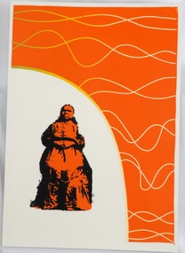
... positioned on the lower left side of the work and portrayed in orange and black. Behind her the background has been left blank. The top and right side of the work has an orange background with white wavy lines....positioned on the lower left side of the work and portrayed in orange and black. Behind her the background has been left blank. The top and right side of the work has an orange background with white wavy lines. ...CEMA Art Collection. Part of "A Community View" 150 years in Portland Screenprint Exhibition. Part of Angela Gee Residency 1983 and 1984.Laminated screenprint of an Aboriginal woman with a white and orange background. The Aboriginal woman appears to be seated and is wearing a full-length dress. She is positioned on the lower left side of the work and portrayed in orange and black. Behind her the background has been left blank. The top and right side of the work has an orange background with white wavy lines.Front: (no inscriptions) Back: 47glenelg shire council cultural collection, portland, 150th anniversary, female artist, female artists, women, gunditjmara -
 Australian Commando Association - Victoria
Book, The Private War of the Spotters: A history of the New Guinea Air Warning Wireless Company, February 1942-April 1945
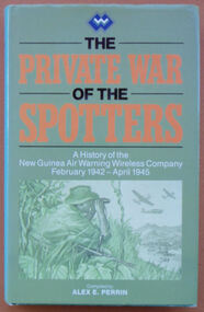
... position was photographed by Damian Parer on the understanding that the pictures would not be published. They nevertheless appeared in a Sydney newspaper. The day after the publication of the photographs the observation post was attacked by the Japanese and Kirkwood was lucky to escape. In June 1944 the company’s headquarters were moved to Nadzab. By that time, spotter stations existed behind Japanese lines ...The history of the New Guinea Air Warning Wireless Company. This reprinted version contains a map of the dispositions of Spotting Stations August 1943, additional MID awards listed and some additions to the nominal roll. The New Guinea Air Warning Wireless Company was formed in Port Moresby in late January 1942 and was granted “Separate Independent Establishment” status in October 1943. The company’s “founding father” was Major Don Small, who had witnessed Japanese air raids on Rabaul and realised that having lacked an effective early-warning system around New Britain meant that the defenders were taken by surprise. At the time, gaps had also appeared in the coast-watching communications network because the territory administration ordered the withdrawal of civilian wireless operators when Japan entered the war. The first influx of men into the company consisted largely of volunteers from the 39th Infantry Battalion, which was stationed at Port Moresby. Initial training was rudimentary, hasty, and was sometimes even carried out on en route to a new station. The first party of company personnel, or “spotters”, left Port Moresby as early as 1 February 1942, bound for the strategically important Samarai area, at the tip of Papua. In the first month of the company’s existence 16 spotter stations were established on the coast of Papua and in the mountains around Port Moresby. At the end of 1942 there were 61 operational stations being run by 180 men. The company’s high-water mark was in late 1944, by which time over 150 stations had been set up in Papua and New Guinea behind enemy lines. On 3 February 1942 the company issued its first air warning in Papua, when spotters at Tufi saw Japanese aircraft about to attack Port Moresby for the first time. The following month the company was responsible for the first Japanese killed in action in Papua by Australian ground forces, when spotters from Gona engaged the crew of a downed Japanese bomber. And in July 1942 the station at Buna signalled Port Moresby with news of the Japanese landings in Papua, marking the beginning of the Kokoda campaign. The dangers involved in the company’s work had also been made clear by this time. In July 1942 a party of spotters attempting to set up a station at Misima Island, off Milne Bay, was intercepted by a Japanese destroyer, resulting in the company’s first operational losses. Anticipating the direction of the campaign as a whole, the company’s focus moved north and north-west over the three years of its existence. In May 1942 a network was set up in the Wau area in association with the activities of Kanga Force. As part of the Wau network, spotter Ross Kirkwood audaciously constructed an observation post overlooking the Japanese airstrip at Salamaua. Kirkwood’s position was photographed by Damian Parer on the understanding that the pictures would not be published. They nevertheless appeared in a Sydney newspaper. The day after the publication of the photographs the observation post was attacked by the Japanese and Kirkwood was lucky to escape. In June 1944 the company’s headquarters were moved to Nadzab. By that time, spotter stations existed behind Japanese lines, as far north as Hollandia, and the company began to train Americans to perform similar work in the Philippines. In early 1945 the company moved to Balcombe, Victoria, where its members were posted to other units of the Australian Corps of Signals.gray plasticnon-fictionThe history of the New Guinea Air Warning Wireless Company. This reprinted version contains a map of the dispositions of Spotting Stations August 1943, additional MID awards listed and some additions to the nominal roll. The New Guinea Air Warning Wireless Company was formed in Port Moresby in late January 1942 and was granted “Separate Independent Establishment” status in October 1943. The company’s “founding father” was Major Don Small, who had witnessed Japanese air raids on Rabaul and realised that having lacked an effective early-warning system around New Britain meant that the defenders were taken by surprise. At the time, gaps had also appeared in the coast-watching communications network because the territory administration ordered the withdrawal of civilian wireless operators when Japan entered the war. The first influx of men into the company consisted largely of volunteers from the 39th Infantry Battalion, which was stationed at Port Moresby. Initial training was rudimentary, hasty, and was sometimes even carried out on en route to a new station. The first party of company personnel, or “spotters”, left Port Moresby as early as 1 February 1942, bound for the strategically important Samarai area, at the tip of Papua. In the first month of the company’s existence 16 spotter stations were established on the coast of Papua and in the mountains around Port Moresby. At the end of 1942 there were 61 operational stations being run by 180 men. The company’s high-water mark was in late 1944, by which time over 150 stations had been set up in Papua and New Guinea behind enemy lines. On 3 February 1942 the company issued its first air warning in Papua, when spotters at Tufi saw Japanese aircraft about to attack Port Moresby for the first time. The following month the company was responsible for the first Japanese killed in action in Papua by Australian ground forces, when spotters from Gona engaged the crew of a downed Japanese bomber. And in July 1942 the station at Buna signalled Port Moresby with news of the Japanese landings in Papua, marking the beginning of the Kokoda campaign. The dangers involved in the company’s work had also been made clear by this time. In July 1942 a party of spotters attempting to set up a station at Misima Island, off Milne Bay, was intercepted by a Japanese destroyer, resulting in the company’s first operational losses. Anticipating the direction of the campaign as a whole, the company’s focus moved north and north-west over the three years of its existence. In May 1942 a network was set up in the Wau area in association with the activities of Kanga Force. As part of the Wau network, spotter Ross Kirkwood audaciously constructed an observation post overlooking the Japanese airstrip at Salamaua. Kirkwood’s position was photographed by Damian Parer on the understanding that the pictures would not be published. They nevertheless appeared in a Sydney newspaper. The day after the publication of the photographs the observation post was attacked by the Japanese and Kirkwood was lucky to escape. In June 1944 the company’s headquarters were moved to Nadzab. By that time, spotter stations existed behind Japanese lines, as far north as Hollandia, and the company began to train Americans to perform similar work in the Philippines. In early 1945 the company moved to Balcombe, Victoria, where its members were posted to other units of the Australian Corps of Signals.world war ii, special operations, new guinea, new guinea air warning wireless company -
 Flagstaff Hill Maritime Museum and Village
Equipment - Ship's Wheel, John Hastie et al, Early 20th Century
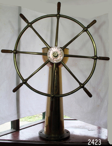
... Top of the ship's wheel pillar has a brass, adjustable arrow pointer that is positioned over a dial etched into the flat brass surface. The dial reads " PORT STABD". Lines...Top of the ship's wheel pillar has a brass, adjustable arrow pointer that is positioned over a dial etched into the flat brass surface. The dial reads " PORT STABD". Lines ...John Hastie Engineer and millwright John Hastie opened small manufacturing works in Greenock in 1845 and 1853 patented the first self-holding steering gear. The firm became known as John, Hastie and Co. Ltd. in 1898 after taking on limited liability status and their main works were at Kilblain Street, Greenock, where they specialised in ships' steering gear. The company also occupied works at Rue End Street, Greenock. Plans of this unit depict a stockyard to the east, with areas for welding; fitting and assembly; flame, cutting and fabrication; and a machine bay. The company was dissolved in 1991. Brown Brothers Brown Bros Rosebank Ironworks made the steering gears for many large ship's, including The Titanic. Andrew Betts Brown the founder was born in 1741 and closely associated with many improvements in marine engineering. He was educated in his native city and served his apprenticeship as an engineer in the locomotive works of the North British Railway Company at St. Margaret's. During his apprenticeship, he attended the evening classes at Watt College. subsequently going to Manchester to study chemistry. He went to London around 1863 and took over an old brewery, which he converted into an engineering works. During his time there he invented an overhead travelling crane, which was used on the construction of Blackfriars Bridge London. He went on to develop plant which used steam and hydraulic power for discharging ships as a result the company was contracted to install this equipment in Hamburg Docks. By around 1870 he continued to construct machinery in London but realised that conditions were more favourable in Edinburgh. He acquired land at Rosebank adjoining the North British Railway Company's line to Granton, and the necessary infrastructure was completed allowing him to finish the Hamburg contract. The works at Rosebank were eventually extended and added to until they became one of the largest engineering works in the East of Scotland. Mr Brown was a member of numerous engineering institutions, the best known at the time being the Institution of Naval Architects. He was also a Fellow of the Royal Society of Edinburgh, a member of the Institute of Mechanical Engineers and of the Institution of Marine Engineers he died in 1906 at the age of 67.An item made by two marine innovators of marine auxiliary machinery, equipment and itemsShip's wheel, brass, attached to brass pillar. The base has six holes in it for securing it in place. Top of the ship's wheel pillar has a brass, adjustable arrow pointer that is positioned over a dial etched into the flat brass surface. The dial reads " PORT STABD". Lines and degrees are marked, with '0' in centre and every 5 degrees, from 0-35, in both Port and Starboard sidesInscription to wheel hub "Brown Brothers & Co. Ltd, Rosebank Ironworks, Edinburgh"flagstaff hill, warrnambool, shipwrecked-coast, flagstaff-hill, flagstaff-hill-maritime-museum, maritime-museum, shipwreck-coast, flagstaff-hill-maritime-village, john hastie, john hastie, andrew betts brown, ships wheel, ship steering gear, marine equipment, instrument, navigation -
 Ararat Gallery TAMA
Mixed media, Inga Hunter, Irusaq Void Sayer's Robe, 1986-1989
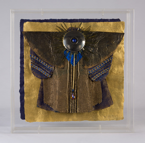
... positions of the three Heads of State and the one Head Speaker, repeat the pattern. The Void itself is always portrayed as an expanding and contracting circle, (not unlike the aperture of a camera). This Robe is worn by the High Priest’s acolyte and spokesman. The Voidsayer interprets the prophesies and sayings of the Priest, in words readily understood by the common people. The disc on the back of the Robe is the Void, and the gold lines...positions of the three Heads of State and the one Head Speaker, repeat the pattern. The Void itself is always portrayed as an expanding and contracting circle, (not unlike the aperture of a camera). This Robe is worn by the High Priest’s acolyte and spokesman. The Voidsayer interprets the prophesies and sayings of the Priest, in words readily understood by the common people. The disc on the back of the Robe is the Void, and the gold lines ...“The lIrusaqi are monotheistic Void worshippers. The Void is an extremely complex concept, and seems to include multiple interpretations of the two great signs, the triangle and the circle. On one level the triangle symbolises Man, and on another, the whole material universe. The Void, symbolised by the circle, is both within and without Man and the material universe. So, we find many variations of the circle and triangle imagery permeating the whole of lrusaqi society, i.e. villages are laid out in pyramid form, with a circular well at the centre, towns are built on a series of triangles, intersected by highways and the Court of the Imperium itself is based on a central circle within a triangle, with delegates to the Court in the three corners, while the positions of the three Heads of State and the one Head Speaker, repeat the pattern. The Void itself is always portrayed as an expanding and contracting circle, (not unlike the aperture of a camera). This Robe is worn by the High Priest’s acolyte and spokesman. The Voidsayer interprets the prophesies and sayings of the Priest, in words readily understood by the common people. The disc on the back of the Robe is the Void, and the gold lines symbolise the words of the Priest, coming from the source of life. The Robe is covered in gold chain mail, a sign that the Robe-wearer will defend his master with his life, if necessary.” -Inga Hunter -
 Ballarat Tramway Museum
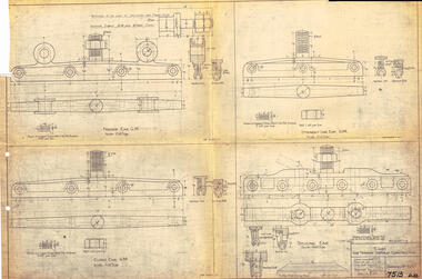
Drawing, Victorian Railways (VR), Ears for Tramway Overhead Construction, 1924
... position. Notes that the drawing was traced in 1924 from a MMTB drawing. Has details for a splicing ear, straight line ear. feeder ear and curve ear along with details for nuts and screws. Yields information about the design of four different types of trolley wire fittings and how they were fabricated for use on the two tram lines, or electric street railways operated by the Victorian Railways. tramways trams overhead Victorian Railways trolley wire engineering electrical engineering Has number "7513 D.33" in black pen in bottom right hand corner. ...Gives the design details of the device or fitting known as a trolley wire ears that holds a tramway copper trolley wire in position. Notes that the drawing was traced in 1924 from a MMTB drawing. Has details for a splicing ear, straight line ear. feeder ear and curve ear along with details for nuts and screws.Yields information about the design of four different types of trolley wire fittings and how they were fabricated for use on the two tram lines, or electric street railways operated by the Victorian Railways.Dyeline print of Victorian Railways drawing number 4057 - Ears for Tramway Overhead ConstructionHas number "7513 D.33" in black pen in bottom right hand corner.tramways, trams, overhead, victorian railways, trolley wire, engineering, electrical engineering -
 Ballarat Tramway Museum
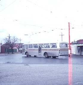
Slide - 27 mm sq slide/s, Lilian Butler, Davis bus (tram service replacement), Oct. 1971
... Ballarat Tramways trams Buses Davis Bus Lines Drummond St Nth Macarthur St Agfa blue and white plastic slide mount of a Davis bus (tram service replacement) turning from Macarthur St into Drummond St North. The overhead remains in position ...Yields information about the replacement bus service and the intersection of Macarthur and Drummond St North.Agfa blue and white plastic slide mount of a Davis bus (tram service replacement) turning from Macarthur St into Drummond St North. The overhead remains in position. Has a large number of passengers on the bus. In the background is the Lisette Beauty Salon. Photo from the collection of Lilian Butler. ballarat, tramways, trams, buses, davis bus lines, drummond st nth, macarthur st -
 University of Melbourne, Burnley Campus Archives
Document - Photocopy, Diane Mathews, Killamont: Conservation Analysis of the Historic Garden of Killamont, July 1991
... Printed sketch of Killamont, Homestead. 20 labelled colour photographs and negatives in a plastic folder labelled, "Killamont very late 1990's or early 2000's." 3 scanned colour photographs from Sandra Pullman.Copy of Handdrawn plan labelled, "Plan showing proposed lines for fencing and tiled drains and position of reception dam in connection with garden scheme K." ...Printed sketch of Killamont, Homestead. 20 labelled colour photographs and negatives in a plastic folder labelled, "Killamont very late 1990's or early 2000's." 3 scanned colour photographs from Sandra Pullman.Copy of Handdrawn plan labelled, "Plan showing proposed lines for fencing and tiled drains and position of reception dam in connection with garden scheme K." ...Copy of Final Project, Dept. of Landscape Architecture, Royal Melbourne Institute of Technology, July 1991 by Diane Matthews. Printed sketch of Killamont, Homestead. 20 labelled colour photographs and negatives in a plastic folder labelled, "Killamont very late 1990's or early 2000's." 3 scanned colour photographs from Sandra Pullman.Copy of Handdrawn plan labelled, "Plan showing proposed lines for fencing and tiled drains and position of reception dam in connection with garden scheme K." Letter to Sandra (Pullman) feom Wendy with attached sletch of the garden 1990.diane matthews, rmit, department of landscape and architecture, killamont, conservation analysis, plan, garden plan -
 Ballarat Tramway Museum
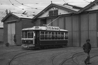
Negative, Bruce Herbert, "Bendigo and Ballarat Trams (AETA Convention) 30 Mar 1975", 30/03/1975 12:00:00 AM
... The junction trackwork for the Eaglehawk lines remain in position. 21 - No. 30 northbound, with the City Family Hotel and other shops in the background. 22 - ditto and the cenotaph, 23 - B74 on a train at Spencer St. ...The junction trackwork for the Eaglehawk lines remain in position. 21 - No. 30 northbound, with the City Family Hotel and other shops in the background. 22 - ditto and the cenotaph, 23 - B74 on a train at Spencer St. ...Negative folder - made by ROW1 International of West Germany containing 40 No. 35 mm negatives of the AETA 1975 Convention visit to Ballarat and Bendigo on 30-3-1975. 17 photos of Ballarat and 23 of Bendigo. Bendigo photos: 1 - No. 28 at the depot 2 - ditto 3 - 24 and another bogie tram in side the depot 4 - No. 3? inside the depot 5 - 12, scrubber - 17 and two bogie trams 6 - scrubber and other bogie trams. 7 - general view with 24 and other bogie trams 8 - ditto 9 - Four trams at the Gold Mine, lead by 28. 10 - 19 at the Gold Mine 11 - single trucker with "tram tours" sign on the front 12 - 28 and two other cars at the Joss House, North Bendigo 13 - 19 and two other cars at the Joss House 14 - 30 at depot junction and loop 15 - 28 and 18 16 - 18 in the loop 17 - 28 and 18 McCrae St 18 - 28, 18 and 30 ditto 19 - 19 20 - No. 18 and 28 in Pall Mall with The Beehive in the background. Outside the building is an American Doughnut Kitchen van. The junction trackwork for the Eaglehawk lines remain in position. 21 - No. 30 northbound, with the City Family Hotel and other shops in the background. 22 - ditto and the cenotaph, 23 - B74 on a train at Spencer St. trams, tramways, btps, ballarat, aeta, bendigo, bendigo trust, depot, mccrae st, tram 28 tram 19 tram 30 tram 18 tram 24 tram 3 tram 12 tram 17 tram scrubber