
Showing 24 items matching "pre-emptive right"
-
 Whitehorse Historical Society Inc.
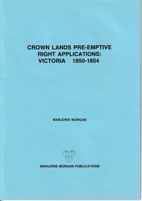
Administrative record - Crown Land Valuations and Applications, Government Printer - John FERRES, Crown Lands Pre-emptive Right Applications: Victoria 1850-1854, 1855
... Crown Lands Pre-emptive Right Applications: Victoria 1850-1854...This document contains the return of all lands alienated from the Crown (in Victoria) and applied for under Pre-Emptive right with the name of Purchaser, etc on 20 April 1855....Contains a valuation for Crown Lands applications under pre-emptive right by Victorian county, giving names of applicants name of run, area, and remarks. ...This document contains the return of all lands alienated from the Crown (in Victoria) and applied for under Pre-Emptive right with the name of Purchaser, etc on 20 April 1855. ...Contains a valuation for Crown Lands applications under pre-emptive right by Victorian county, giving names of applicants name of run, area, and remarks.Contains a valuation for Crown Lands applications under pre-emptive right by Victorian county, giving names of applicants name of run, area, and remarks. Contains a valuation for Crown Lands applications under pre-emptive right by Victorian county, giving names of applicants name of run, area, and remarks. clarke andrew, anglesey, evelyn, bourke, dalhousie, dundas, follett, grant, hampden, heytesbury, normanby, polwarth, ripon, talbot, villiers, district of murray, district of wimmera, district of western port, early settlement, mornington -
 Phillip Island and District Historical Society Inc.
Book, MORGAN, Marjorie, Crown lands pre-emptive right applications : Victoria 1850-1854, 1987
... Crown lands pre-emptive right applications : Victoria 1850-1854...First published as: Valuation of Crown Lands under Pre-emptive Right. Melbourne : 1855....First published as: Valuation of Crown Lands under Pre-emptive Right. Melbourne : 1855. Crown lands pre-emptive right applications : Victoria 1850-1854 Book MORGAN, Marjorie Marjorie Morgan Publications ...Stamped 'Phillip Island & District Historical Society'. Facsim. reprint. First published as: Valuation of Crown Lands under Pre-emptive Right. Melbourne : 1855.land settlement, victoria, history, land subdivision -
Federation University Historical Collection
Plan, Ballarat - Mining Lease No 5611
... ...pre-emptive right...Plan showing mining lease no 5611 along Yarrowee Creek, Ballarat. Bonshaw Pre-Emptive Right is recorded on the plan....Bonshaw Pre-Emptive Right is recorded on the plan. Ballarat - Mining Lease No 5611 Plan ...Plan showing mining lease no 5611 along Yarrowee Creek, Ballarat. Bonshaw Pre-Emptive Right is recorded on the plan.ballarat, yarrowee, yarrowee creek, mining, mining lease, ballaarat, bonshaw, magpie, pre-emptive right -
 Federation University Historical Collection
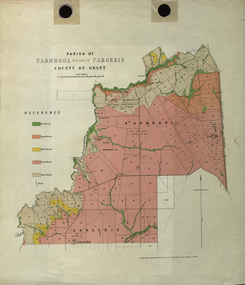
Plan - Map, Mines Department, Parish of Narmbool and part of Cargerie, County of Grant, 1892, 06/1992
... ...narmbool pre-emptive right...This map shows the position of the homestead on the Narmbool Pre-emptive Right, volcanic craters, stock reserve, quarry and geological eras,...This map shows the position of the homestead on the Narmbool Pre-emptive Right, volcanic craters, stock reserve, quarry and geological eras, narmbool cargerie narmbool pre-emptive right williamson's creek leigh river green hill collyer's hill volcano crater krause ferdinand krause Geological map showing Narmbool and part of Cargerie in the County of Grant in five colours, predominantly pink. ...This map shows the position of the homestead on the Narmbool Pre-emptive Right, volcanic craters, stock reserve, quarry and geological eras,Geological map showing Narmbool and part of Cargerie in the County of Grant in five colours, predominantly pink.narmbool, cargerie, narmbool pre-emptive right, williamson's creek, leigh river, green hill, collyer's hill, volcano, crater, krause, ferdinand krause -
 Federation University Historical Collection
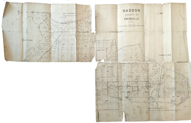
Plan, Haddon County of Grenville, 1887, 1887
... ...nentingbook pre-emptive right...Parish Plan of Haddon showing the township of Haddon, Cardigan and Haddon State Forest, Lake Burrumbeet and Nentingbook Pre-emptive Right. Names on the allotments include H. ...haddon cardigan haddon state forest lake burrumbeet nentingbook pre-emptive right h. cuthbert b. hepburn t.w. lloyd j. palmer e.a. wynne william collard smith a. porteous p. russell j. mitchell g. rennie j. noone department of lands and survey handwritten 'J. ...Parish Plan of Haddon showing the township of Haddon, Cardigan and Haddon State Forest, Lake Burrumbeet and Nentingbook Pre-emptive Right. Names on the allotments include H. Cuthbert, B. Hepburn, T.W. Lloyd, J. Palmer, E.A. Wynne, William Collard Smith, A. Porteous, P. Russell, J. Mitchell, G. Renniehandwritten 'J. H. Cunningham Applic'haddon, cardigan, haddon state forest, lake burrumbeet, nentingbook pre-emptive right, h. cuthbert, b. hepburn, t.w. lloyd, j. palmer, e.a. wynne, william collard smith, a. porteous, p. russell, j. mitchell, g. rennie, j. noone, department of lands and survey -
 Federation University Historical Collection
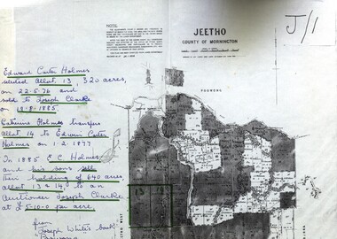
Map - Documents, Documents relating to Land - Selection of Maps of subdivisions; Titles; Cemetery sections
... ...pre-emptive right...Maps indicate the land owned in various areas of Victoria - Mornington Peninsula, Ascot / Creswick area jeetho county of mornington edward carter holmes joseph clarke catherine holmes talbot william coghill pre-emptive right tourello pre-emptive right glendonald pre-emptive right clunes smeaton ascot counties of ripon and talbot certificate of title ballaarat general cemetery new cemetery Poowong Helen Coghill Land maps showing block divisions and owners. ...Maps indicate the land owned in various areas of Victoria - Mornington Peninsula, Ascot / Creswick areaLand maps showing block divisions and owners. Edward Carter Holmes J.P. selected land and called it Launchley - later called Wambalano.jeetho, county of mornington, edward carter holmes, joseph clarke, catherine holmes, talbot, william coghill, pre-emptive right, tourello pre-emptive right, glendonald pre-emptive right, clunes, smeaton, ascot, counties of ripon and talbot, certificate of title, ballaarat general cemetery, new cemetery, poowong, helen coghill -
 Federation University Historical Collection
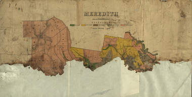
Plan, Meredith Geological Map
... borhoneyghurk pre-emptive right...meredith borhoneyghurk pre-emptive right borhoneyghurk east pre-emptive right Coloured map of Meredith backed onto sheets of paper. ...Coloured map of Meredith backed onto sheets of paper.meredith, borhoneyghurk pre-emptive right, borhoneyghurk east pre-emptive right -
 Federation University Historical Collection
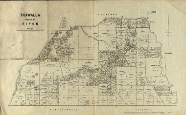
Parish Plan, Parish Plan of Trawalla in the Parish of Rippon, 1913, 28/4/1913
... ...trawalla pre-emptive right...Trawalla is surrounded by Beaufort, Brewster, Lillirie, Yangerahwill and Eurambee. trawala ripon westbrok simson mackenzie mcarthur wilson nicholason gibb read hayward topper foreman bell mcmillan halpin davis goldsmith trawalla pre-emptive right butson w.j. butson m4471 w. read c.a. foreman j. simson a. goldsmith trawalla g. topper Parish Plan of Trawalla in the Parish of Rippon. ...Trawalla is surrounded by Beaufort, Brewster, Lillirie, Yangerahwill and Eurambee.Parish Plan of Trawalla in the Parish of Rippon. trawala, ripon, westbrok, simson, mackenzie, mcarthur, wilson, nicholason, gibb, read, hayward, topper, foreman, bell, mcmillan, halpin, davis, goldsmith, trawalla pre-emptive right, butson, w.j. butson, m4471, w. read, c.a. foreman, j. simson, a. goldsmith, trawalla, g. topper -
 Federation University Historical Collection
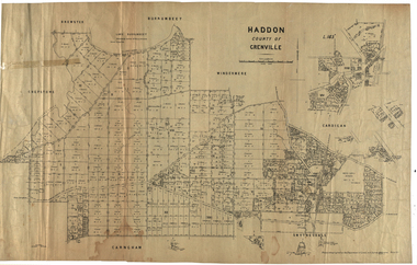
Plan, Haddon, County of Grenville, 1932, 13/04/1932
... ...nentingbook pre-emptive right...haddon grenville cardigan water supply reserve nentingbook pre-emptive right a. mclachlan lake burrumbeet e.a. wynne p. russell b. hepburn benjamin hepburn nentingbool t.c. wilson j. amoy william collard smith james roach j. mitchell The Haddon Parish Plan shows crown parcels government roads, Crown Reserves, Railway. ...The Haddon Parish Plan shows crown parcels government roads, Crown Reserves, Railway. Scale 40 chains to 1" (1:31, 680) WGS 84 Centroid Lat: 37 degrees 34' 00" S Long: 148 degrees 40' 20" E N.S. 9.3km E.W.: 16.1kmhaddon, grenville, cardigan, water supply reserve, nentingbook pre-emptive right, a. mclachlan, lake burrumbeet, e.a. wynne, p. russell, b. hepburn, benjamin hepburn, nentingbool, t.c. wilson, j. amoy, william collard smith, james roach, j. mitchell -
 Federation University Historical Collection
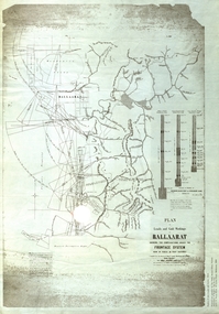
Plan, Plan of Leads and Gold Workings at Baallarat Showing the Complications Under the Frontage System, 1863, 1863
... ...winter's pre-emptive right...Facsimile of a plan held by the Public Record Office Victoria. ballarat mining inkermann lead golden point lead robert davidson terrible lead white horse lead frenchman's lead little magpie lead milkmaid's lead woolshed lead nuggety lead blackman's lead canadian lead sailor's gully lad nightingale lead malakoff lead black hill gully pennyweight flat black hill winter's pre-emptive right nelson company great extended great republic lead cgt Facsimile of a plan of Ballarat showing leads, gold workings an dthe frontage system. ...Facsimile of a plan held by the Public Record Office Victoria. Facsimile of a plan of Ballarat showing leads, gold workings an dthe frontage system.ballarat, mining, inkermann lead, golden point lead, robert davidson, terrible lead, white horse lead, frenchman's lead, little magpie lead, milkmaid's lead, woolshed lead, nuggety lead, blackman's lead, canadian lead, sailor's gully lad, nightingale lead, malakoff lead, black hill gully, pennyweight flat, black hill, winter's pre-emptive right, nelson company, great extended, great republic lead, cgt -
 Federation University Historical Collection
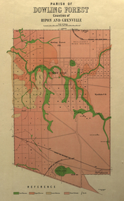
Plan, Parish of Dowling Forest, County of Ripon and Grenville, 19
... ...wyndholm pre-emptive right...Scale [1:31 680]. 40 chains to 1 in. dowling forest wyndholm wyndholm pre-emptive right miners rest ballarat racecourse winter's swamp police reserve miner's rest winters swamp geology Geological map on a cadastral base, showing the occurence of reefs, and alluvial deposits. ...Scale [1:31 680]. 40 chains to 1 in.Geological map on a cadastral base, showing the occurence of reefs, and alluvial deposits. Relief shown by contours.dowling forest, wyndholm, wyndholm pre-emptive right, miners rest, ballarat racecourse, winter's swamp, police reserve, miner's rest, winters swamp, geology -
 Federation University Historical Collection
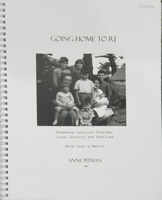
Book, Anne Pitman, Going Home to RJ: Rokewood Junction Stories, Local History and Families: More than a Memoir, 2023
... ...Dereel Pre-emptive Right...Dereel pitfield Wadawurrung William rutland squatters Aborigines Aboriginal Charlotte Walsh Maurice Walsh Julie Pitman Ben Liston sheep and wool George Hawkins Natthew Wakeling Christopher Moody mt misery goldfield John Bower Mary Bower Hyslop's Hotel Cumberland Store Jane Hyslop edward Collyer Jospeh Gladstone Lucas's Bakery Henry Batty William Young Ellen Rigby chinese Joseph Anguey Eliza Anguey Murder of Thomas Ulick Burke William Achultze William Schiltze Nicholas grenfell Tomas Bramley murder Emily Malhoff drowning Ah Lin Eliza Richards Luisa Bupell Eleanor Holmes Rachel Holmes Joseph Holloway Noah Holloway Thomas Faulkner Robert Eli HEarn George Todhunter Briggs John Robinson Fairweather Rokewood Common Edward Bussell Louisa Bussell Irving Rachinger john chatham Doris Chatham Peter Chatham Jack Chatham Imogen Chatham Domenico Rizzoli Mary Rizzoli Rokewood Junction Railway Line Illabrook Football and Netball Club Cape Clear Red Cross keith Annear Fire brigade Rokewood Junction Post Office Len Aarons Dereel Pre-emptive Right Rokewood Junction Avenue of Honour arthur chatham Beverley Chatham ( daughter of Arthur Chatham) suggested that Commerlghip refers to Watering holes and underground springs found in the Little Woady Yallok and Mt Misery Creeks. ...Beverley Chatham ( daughter of Arthur Chatham) suggested that Commerlghip refers to Watering holes and underground springs found in the Little Woady Yallok and Mt Misery Creeks. Rokewood Junction was proclaimed a township in 1885, originally known as a gold-mining township called Paddy's Gully Diggings.Ringbound publication of 212 pagesnon-fictionBeverley Chatham ( daughter of Arthur Chatham) suggested that Commerlghip refers to Watering holes and underground springs found in the Little Woady Yallok and Mt Misery Creeks. Rokewood Junction was proclaimed a township in 1885, originally known as a gold-mining township called Paddy's Gully Diggings. rokewood, rokewood junction, chatham, kurus-a-ruc, henry pitman, elizabeth pitman, william henry pitman, rokewood junction state school, commeralghip, paddy's gully bridge, illabrook, conereyalk, woady yalloak creek, mt misery creek, paddy's gully diggings., dereel, pitfield, wadawurrung, william rutland, squatters, aborigines, aboriginal, charlotte walsh, maurice walsh, julie pitman, ben liston, sheep and wool, george hawkins, natthew wakeling, christopher moody, mt misery goldfield, john bower, mary bower, hyslop's hotel, cumberland store, jane hyslop, edward collyer, jospeh gladstone, lucas's bakery, henry batty, william young, ellen rigby, chinese, joseph anguey, eliza anguey, murder of thomas ulick burke, william achultze, william schiltze, nicholas grenfell, tomas bramley murder, emily malhoff, drowning, ah lin, eliza richards, luisa bupell, eleanor holmes, rachel holmes, joseph holloway, noah holloway, thomas faulkner, robert eli hearn, george todhunter briggs, john robinson fairweather, rokewood common, edward bussell, louisa bussell, irving rachinger, john chatham, doris chatham, peter chatham, jack chatham, imogen chatham, domenico rizzoli, mary rizzoli, rokewood junction railway line, illabrook football and netball club, cape clear, red cross, keith annear, fire brigade, rokewood junction post office, len aarons, dereel pre-emptive right, rokewood junction avenue of honour, arthur chatham -
 Narre Warren and District Family History Group
Book, Context Pty Ltd, Cardinia Local Heritage Study Review 2007 Stage A. Vol 1 : Key Findings And Recommendations Vol 2 : Heritage Place And Precinct Citations, 2007
... ...I.Y.U. Pre-emptive Right Homestead site (Pakenham)...Cardinia Shire (Vic.) heritage studies Kenilworth Coach House (Beaconsfield) Wood Street Residential Precinct (Beaconsfield) George Street Residential Precinct (Bunyip) Bunyip Post Office Railway Hotel (Bunyip) Cora Lynn Catholic Parish School Glen-Keith Farm Complex (Dalmore) Emerald Lake Park Emerald Railway Station Emerald Country Club Cambden Woolybutt Ros (Emerald) Oak Lee (Emerald) Sycamore Lodge (Emerald) Cascades Guest house Orchard Packing Shed (Garfield North) Wattle Bank (Gembrook) Coffee Palace (Gembrook) Tehennepe (Iona) Koo Wee Rup Public Hall Dustings Garage (Koo Wee Rup) Wattle Theatre (Koo Wee Rup) Koo Wee Rup Police Lockup Royal Hotel (Koo Wee Rup) Lang Lang Cemetery Misson's Butchers Shop & Residence (Lang Lang) ANZ Bank (Lang Lang) Maryknoll Residential & Civic Precinct Maryknoll Lawn Cemetery Mount Burnett Guesthouse Oakway (Nar Nar Goon) Nar Nar Goon Growers & Packers Shed Jesmond Dene (Officer South) Kings Picture Theatre (Pakenham) Pakenham Post Office I.Y.U. Pre-emptive Right Homestead site (Pakenham) Valley View Orchards Manager's House (Pakenham Upper) Ruthdale Reserve Trees Rutter Farm Trees (Tooradin) Eve's House (Tynong North) Kia Ora (Upper Beaconsfield) The Steyne (Upper Beaconsfield) Beaconsfield Upper Milk Bar Staverton Garden (Upper Beaconsfield) Great Southern Railway The overall objective of the Study was the identification, assessment and documentation of places of post-contact cultural significance for the Cardinia Shire. ...The overall objective of the Study was the identification, assessment and documentation of places of post-contact cultural significance for the Cardinia Shire.non-fictionThe overall objective of the Study was the identification, assessment and documentation of places of post-contact cultural significance for the Cardinia Shire.cardinia shire (vic.), heritage studies, kenilworth coach house (beaconsfield), wood street residential precinct (beaconsfield), george street residential precinct (bunyip), bunyip post office, railway hotel (bunyip), cora lynn catholic parish school, glen-keith farm complex (dalmore), emerald lake park, emerald railway station, emerald country club, cambden woolybutt ros (emerald), oak lee (emerald), sycamore lodge (emerald), cascades guest house, orchard packing shed (garfield north), wattle bank (gembrook), coffee palace (gembrook), tehennepe (iona), koo wee rup public hall, dustings garage (koo wee rup), wattle theatre (koo wee rup), koo wee rup police lockup, royal hotel (koo wee rup), lang lang cemetery, misson's butchers shop & residence (lang lang), anz bank (lang lang), maryknoll residential & civic precinct, maryknoll lawn cemetery, mount burnett guesthouse, oakway (nar nar goon), nar nar goon growers & packers shed, jesmond dene (officer south), kings picture theatre (pakenham), pakenham post office, i.y.u. pre-emptive right homestead site (pakenham), valley view orchards manager's house (pakenham upper), ruthdale reserve trees, rutter farm trees (tooradin), eve's house (tynong north), kia ora (upper beaconsfield), the steyne (upper beaconsfield), beaconsfield upper milk bar, staverton garden (upper beaconsfield), great southern railway -
 Ballarat Heritage Services
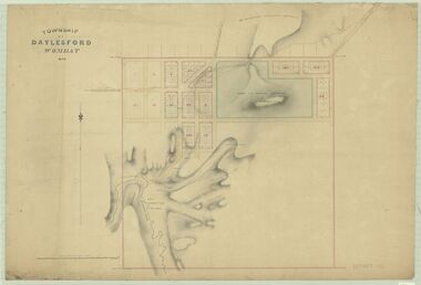
Plan, Daylesford Wombat Plan, 1854
... ...Stanbridge Pre-emptive right...Daylesford Wombat Tipperary Wombat Flat Wombat Creek Boiling Planning Spring Specimen Hill Wombat Hill Police Camp Stanbridge Stanbridge Pre-emptive right Daylesford Wombat Plan Plan ...daylesford, wombat, tipperary, wombat flat, wombat creek, boiling planning spring, specimen hill, wombat hill, police camp, stanbridge, stanbridge pre-emptive right -
Lakes Entrance Historical Society
Book, Marjorie Morgan, Crown Lands Pre-emptive Rights Agreement, 1987
... Fasimile reproduction of Victorian Government records giving valuation of Crown Lands under Pre emptive right originally printed in sixteen counties and four districts are included....Settlers Surveying Land Settlement Fasimile reproduction of Victorian Government records giving valuation of Crown Lands under Pre emptive right originally printed in sixteen counties and four districts are included. ...Fasimile reproduction of Victorian Government records giving valuation of Crown Lands under Pre emptive right originally printed in sixteen counties and four districts are included.settlers, surveying, land settlement -
 Warrnambool and District Historical Society Inc.
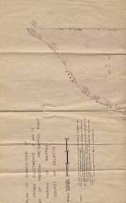
Subdivision plan, Part of Preston Estate Parish of Wappan
... Plan of subdivision of part of crown allotments 15 and 17 and part of Preston pre- emptive right, Parish of Wappan, County of Delatite....Part of a collection of papers relating to the Bostock family one of the earliest pioneering families in Warrnambool. warrnambool,bostock,augustus bostock map, delatite map,district of wappan map, Plan of subdivision of part of crown allotments 15 and 17 and part of Preston pre- emptive right, Parish of Wappan, County of Delatite. ...This map possibly relates to land of John Bostock at Preston, Delatite. Part of a collection of papers relating to the Bostock family one of the earliest pioneering families in Warrnambool.Cream coloured map printed in black with sections coloured in pink. Plan of subdivision of part of crown allotments 15 and 17 and part of Preston pre- emptive right, Parish of Wappan, County of Delatite.warrnambool,bostock,augustus bostock map, delatite map,district of wappan map, -
 Federation University Historical Collection
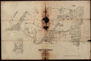
Plan, Smythesdale, County of Grenville, 01/12/1892
... A plan showing the Borough of Smythesdale, Smythesdale, Browns and Scarsdale, allotments, water reserve, Timber reserve, Nintingbool Pre-emptive Right, Reserve for public gardens, Reserve for Cricket Ground, Reserve for Reservoir...Gift of the Squire Family smythesdale scarsdale browns yarrowee carngham samuel barlett sheridan wrigley p. land r. simpson d. davis nintingbool mclachlan a. mclachlan c. taylor w. c. smith d. davies w. williams m. jones t. mcgurk r. selkirk a. mooney A plan showing the Borough of Smythesdale, Smythesdale, Browns and Scarsdale, allotments, water reserve, Timber reserve, Nintingbool Pre-emptive Right, Reserve for public gardens, Reserve for Cricket Ground, Reserve for Reservoir Smythesdale, County of Grenville Plan Department of Lands and Survey T.F. ...This plan is associated with former Ballarat School of Mines Student Richard Squire (1875-1876). Gift of the Squire FamilyA plan showing the Borough of Smythesdale, Smythesdale, Browns and Scarsdale, allotments, water reserve, Timber reserve, Nintingbool Pre-emptive Right, Reserve for public gardens, Reserve for Cricket Ground, Reserve for Reservoirsmythesdale, scarsdale, browns, yarrowee, carngham, samuel barlett, sheridan, wrigley, p. land, r. simpson, d. davis, nintingbool, mclachlan, a. mclachlan, c. taylor, w. c. smith, d. davies, w. williams, m. jones, t. mcgurk, r. selkirk, a. mooney -
 Federation University Historical Collection
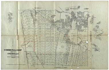
Plan, Commeralghip, County of Grenville, 1905, 03/02/1905
... The plan includes the township of Kaleno, Dereel Pre-Emptice Right (John Cullen), Commeralghip Pre-Emptive Right (John Gordon McMillan and Glenfine Pre-Emptive Right (William Rowe). ...The plan includes the township of Kaleno, Dereel Pre-Emptice Right (John Cullen), Commeralghip Pre-Emptive Right (John Gordon McMillan and Glenfine Pre-Emptive Right (William Rowe). ...The Township of Kaleno is in the Pitfield Plains. The Cape Clear Cemetery T contains the graves of miners and local pioneering families from the Cape Clear, Hollybush, Kaleno, Pitfield Plains, Pitfield, Illabarook, Berringa, Springdallah, Wallinduc, Glenfine, Happy Valley and Western Creek districts.Plan of allotments in Commeralghip, County of Grenville, Victoria. The plan includes the township of Kaleno, Dereel Pre-Emptice Right (John Cullen), Commeralghip Pre-Emptive Right (John Gordon McMillan and Glenfine Pre-Emptive Right (William Rowe). It also includes landholders such as Robert mcPherson, C. Cameron. John Boyd, John Cullen, W.T. Rowe, George Currie, J.P. Mackay, T. McCaffery, G. Hawkins, Alexander McPherson, C. Cameron. Gift of the Squire Family, 2014commeralghip, pitfield plains, kaleno, dereel, glenfine, squire, richard squire, w.t. rowe, john cullen, alexander mcpherson, george currie, mt misery, william rowe, mindai, john gordon mcmillan -
 Federation University Historical Collection
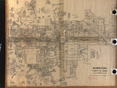
Plan, Department of Crown Lands and Survey, Melbourne, Buninyong County of Grant, 23/07/1929
... A parish plan of Buninyong, including Robert Scott's Mt Buninyong Pre-emptive Right, Mt Buninyong Public Park, Thomas Learmonth's land, John Learmonth's land, Scotchan's, Yendon. ...Forrest Parkin Lee Buninyong Recreation Reserve A parish plan of Buninyong, including Robert Scott's Mt Buninyong Pre-emptive Right, Mt Buninyong Public Park, Thomas Learmonth's land, John Learmonth's land, Scotchan's, Yendon. ...The plan was photo-lithographed at the Departmen tof Lands and Survey, MelbourneA parish plan of Buninyong, including Robert Scott's Mt Buninyong Pre-emptive Right, Mt Buninyong Public Park, Thomas Learmonth's land, John Learmonth's land, Scotchan's, Yendon. The Buninyong POst Office is Allotment 1. Pisition of tracks in 1859 have been marked on the plan in red.buninyong, scotchman's, mt buninyong, robert scott, clarendon, lal lal creek, yendon, warrenheip, yarowee, enfield, thomas learmonth, john learmonth, archibald fisken, g. schloo, george innes, peter inglis, durham lead, j. fry, j. forrest, parkin lee, buninyong recreation reserve -
 Wodonga & District Historical Society Inc
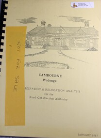
Booklet - Cambourne Wodonga : Conservation & Relocation Analysis for the Road Construction Authority, John & Thurley O'Conner, 1987
... The township of Belvoir, renamed Wodonga in 1874, was surveyed in 1852, and in 1855 the pre-emptive right of 171 acres of the Wodonga run was granted and sold the following year. ...The township of Belvoir, renamed Wodonga in 1874, was surveyed in 1852, and in 1855 the pre-emptive right of 171 acres of the Wodonga run was granted and sold the following year. ...Research paper into the viability of relocating Cambourne Homestead in 2006 in order to make way for the widening and upgrade of the Hume Highway.non-fictionResearch paper into the viability of relocating Cambourne Homestead in 2006 in order to make way for the widening and upgrade of the Hume Highway. cambourne homestead wodonga, heritage building wodonga, carkeek family, potter family, building relocation -
 Bendigo Historical Society Inc.
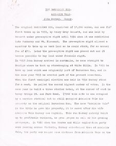
Document - BARNADOWN RUN: SHORT PAPER JOHN HARNEY
... The original Barnedown Run consisted of 51,280 acres and was first taken up in 1839 by Henry Grey Bennett and was held under "Pre-emptive right" until it was subdivided in 1856 into Muskerry and Mt. ...Pre-emptive rights White Hills Adelaide Vale Bourke and Wills Edward O'Keefe Cecil Hyatt Mr Frank K. Hill. Basrnadown Run John Harney The original Barnedown Run consisted of 51,280 acres and was first taken up in 1839 by Henry Grey Bennett and was held under "Pre-emptive right" until it was subdivided in 1856 into Muskerry and Mt. ...The original Barnedown Run consisted of 51,280 acres and was first taken up in 1839 by Henry Grey Bennett and was held under "Pre-emptive right" until it was subdivided in 1856 into Muskerry and Mt. Pleasant. In 1853 John Harney arrived in Australia and took up storekeeping at White Hills. In 1855 he took up land which was originally part of Barnadown Run and erected part of the present homestead. In 1860 Harney entertained Burke and Wills exploration party at Adelaide Vale on the Campaspe River. Mr Harney owned a Hotel which was burnt down in 1861. Henry Grey Bennett a generous man died in1871 and the citizens of Bendigo erected a 20ft monument over his grave.John Harneyjohn harney, john harney, henry grey bennett, pre-emptive rights, white hills, adelaide vale, bourke and wills, edward o'keefe, cecil hyatt, mr frank k. hill., basrnadown run -
 Wodonga & District Historical Society Inc
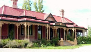
Photograph - Cambourne House
... In 1855 the pre-emptive right of 171 acres of the Wodonga Run was granted and sold the following year. ...In 1855 the pre-emptive right of 171 acres of the Wodonga Run was granted and sold the following year. ...Cambourne homestead was built by 1903 for Rebecca S. Carkeek, who purchased the property in Wodonga in 1899. Cambourne is situated on the original Wodonga Run which was established in 1836. In 1855 the pre-emptive right of 171 acres of the Wodonga Run was granted and sold the following year. The allotments on which the five-acre Cambourne property developed, were purchased in 1873 and 1876, coinciding with the opening of the Railway from Melbourne. The property was purchased by Rebecca Carkeek in June 1899, wife of William Carkeek, Publican of Wodonga and Shire Councillor. Local architects Gordon and Gordon have been credited with the design of Cambourne. The house at Cambourne was built at some stage between 1900 and 1903 as a large single storey homestead. It was constructed in red brick with corrugated iron roof and encircling verandah. Cambourne is a probable work of architects Gordon and Gordon, it is amongst their best preserved and one of their few surviving buildings in Victoria. Today Cambourne remains on a reduced allotment due to the acquisition of land in 1972 by the Country Roads Board and in 2006 by Vic Roads for road works adjacent to the property.Cambourne, Wodonga is of architectural and historical significance to the State of Victoria.A set of coloured photos depicting Cambourne in Wodonga. Part of a collection documented a heritage listed pioneer home.cambourne wodonga, cambourne homestead wodonga, historic buildings wodonga -
 Wodonga & District Historical Society Inc
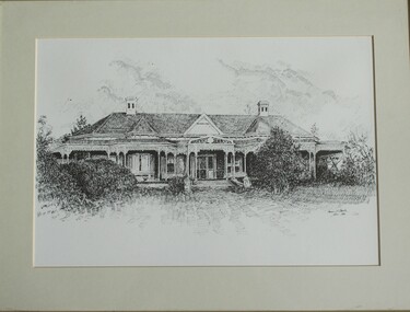
Drawing - Cambourne House, Kevin P. Clark, 1984
... In 1855 the pre-emptive right of 171 acres of the Wodonga run was granted and sold the following year. ...In 1855 the pre-emptive right of 171 acres of the Wodonga run was granted and sold the following year. ...Cambourne homestead was built by 1903 for Rebecca S. Carkeek, who purchased the property in Wodonga in 1899. Cambourne is situated on the original Wodonga run which was established in 1836. The township of Belvoir, later renamed as Wodonga. In 1855 the pre-emptive right of 171 acres of the Wodonga run was granted and sold the following year. The allotments on which the five-acre Cambourne property developed, were purchased in 1873 and 1876, coinciding with the opening of the railway from Melbourne. The property was purchased by Rebecca Carkeek in June 1899, wife of William Carkeek, publican of Wodonga and shire councillor. Local architects Gordon and Gordon have been credited with the design of Cambourne. The house at Cambourne was built at some stage between 1900 and 1903 as a large single storey homestead. It was constructed in red brick with corrugated iron roof and encircling verandah. Cambourne is a probable work of architects Gordon and Gordon, it is amongst their best preserved and one of their few surviving buildings in Victoria. Today Cambourne remains on a reduced allotment due to the acquisition of land in 1972 by the Country Roads Board and in 2006 by Vic Roads for road works adjacent to the property.This drawing is significant as a representation of Cambourne in Wodonga. Cambourne is of historical significance due to its links with the early settlement of the district and as an example of closer settlement which occurred in regional centres of the State. Cambourne, Wodonga is also of architectural significance as a largely intact late Victorian style house with elaborate decorative cast iron work and distinctive transverse plan. As a probable work of architects Gordon and Gordon, it is amongst their best preserved and one of their few surviving buildings in Victoria. A framed drawing of historic home, Cambourne in Wodonga. The drawing has been mounted and framed.On bottom right corner" Kevin P. Clark 1984"cambourne wodonga, gordon and gordon architects, historic buildings wodonga, heritage buildings wodonga -
 Federation University Historical Collection
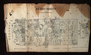
Plan, Burrumbeep, 1884, 16/10/1884
... The plan includes the Burrumbeep Pre-Emptive Right (Roger and Wright); licensed land holders including Stephen Young, John Carroll, William Walsh, Thomas Purcell, Martha M. ...The plan includes the Burrumbeep Pre-Emptive Right (Roger and Wright); licensed land holders including Stephen Young, John Carroll, William Walsh, Thomas Purcell, Martha M. ...Auctions of Crown land were introduced in the Colony of Victoria from 1851 to encourage settlers to occupy and work the land. Many squatters purchased land at auction at the upset (minimum) price of £1 per acre. In some areas where demand was high, such as the goldfields, the price realised at auction was much more. Land was put up for sale in the study area on the Burrumbeep run in May 1855, on the Lexington run in 1857, and on the Gorrinn run in 1858. (http://www.ararat.vic.gov.au/library/document/thermatics.pdf, accessed 27 January 2015) For 70 years or more, Yalla-y-Poora, Burrumbeep, Edgarley, Mount William and Narrapumelap ranked in the leading wool producers in Victoria. 1 Stud owners at Yalla-y-Poora, Eurambeen, Burrumbeep and Challicum crossed merino sheep with sheep descended from John Macarthur's Camden Park in New South Wales. (http://www.ararat.vic.gov.au/library/document/thermatics.pdf, accessed 27 January 2015) In what was to become the Ararat Mining Division, gold was discovered in May 1854 on the Burrumbeep run at a place that became known as Pinky Point on the Mount William goldfield. By 21 June 1854, between 600 and 1,000 people had arrived. (http://www.ararat.vic.gov.au/library/document/thermatics.pdf, accessed 27 January 2015)\ Town allotment plan for Burrumbeep. Merrymbuela, Borung, Lexington and Langi Logan are neighbouring areas. The plan includes the Burrumbeep Pre-Emptive Right (Roger and Wright); licensed land holders including Stephen Young, John Carroll, William Walsh, Thomas Purcell, Martha M. Bond, Colin Johnson, John Charles Webb, Henry Withycombe, William Henry Barbridge, John Wall, Thomas Flatelly, William Jenkinson, Elisia Radford, V. Radford, Denis Byrne, George Cook. Land holders included Andrew Maloney, Richard Wingfield Harrocks, W. Sporton, Terence Lynch, F. S. Falkiner, A. Millman, H. Morris, George Upham, J. McCLure, S. Fletcher, W. Parker, Thomas Myers, William wright, W.C. Winter, C. Wordman, Oliver A. Winter This plan is associated with former Ballarat School of Mines student Richard Squire (1875-6) Gift of the Squire FamilyVerso written in pencil - Plan of Burrembeep Ararat Burrembeep Araratburrumbeep, corrinn, langi logan, merrymbuela, lexington, ararat, roger & wright, cook, rogers, upham, george upham, ross, parsans, morris, johnson, withycoombe, colin johnson, falkiner, dsporton, john carroll, donald gordon, denis bryne, maurice dooley, martha bond, william harricks, \william wingfield harricks, william l.c. harricks, michael houlihan, thomas purcell, martin ryan, michael cody, fletcher, mccaw, w. parker, j.m. clow, elisia radford, thomas radford, thomas myers, barbridge, e. wilde, j. wall, flatelly, g. wardman, w.c. winter, david ball, jenkinson, ballarat school of mines, richard squire, squire
