Showing 280 items matching "progress park"
-
 Bayside Gallery - Bayside City Council Art & Heritage Collection
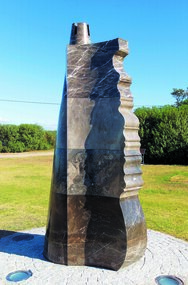
Sculpture, Faustas Sadauskas, The Beacon, 2003
... ...Progress park...Public art commission located at Progress Park on the Black Rock Foreshore....Public art commission located at Progress Park on the Black Rock Foreshore. The Beacon Sculpture sculpture Faustas Sadauskas ...Public art commission located at Progress Park on the Black Rock Foreshore.Inscribed with text that is an extract from a verse sung by Lithuanian displaced persons sailing to Australia having fled their homeland after Russian occupation following World War II. The text is in an ancient Runic typeface, translated in English, reads: "Faustas Sadauskas created Beacon two thousand [and] four years / Let the Blowing Wind Who Taketh the Ship Away Take Me Away".beacon, sculpture, faustas sadauskas, bayside coastal trail, marble, public art, black rock, foreshore, beach road, progress park, ship, rudder -
 Ringwood and District Historical Society
Letter, Muller, George W, Correspondence and newspaper clipping from Heathmont Progress League regarding Heathmont Park 14/10/1929, 14-Oct-29
... Correspondence and newspaper clipping from Heathmont Progress League regarding Heathmont Park 14/10/1929....George Muller Hon Sec of the Heathmont Progress League wrote to the Town Clerk about the management of Heathmont Park....One page handwritten letter from George Muller Hon Sec of the Heathmont Progress League to the Town Clerk about the management of Heathmont Park. Buff coloured, lined page, plus newspaper item - Rate Collectors Report. ...Correspondence and newspaper clipping from Heathmont Progress League regarding Heathmont Park 14/10/1929. Letter Muller, George W ...George Muller Hon Sec of the Heathmont Progress League wrote to the Town Clerk about the management of Heathmont Park.One page handwritten letter from George Muller Hon Sec of the Heathmont Progress League to the Town Clerk about the management of Heathmont Park. Buff coloured, lined page, plus newspaper item - Rate Collectors Report. +Additional Keywords: Muller, George W. -
 Eltham District Historical Society Inc
Photograph, Michael Wood, Houses on Progress Road viewed from Glen Park Road, Eltham North, February 1970, 1970
... Houses on Progress Road viewed from Glen Park Road, Eltham North, February 1970...alistair knox design, eltham north, hellemon, houses, progress road, Glen Park Road...Inscribed in ink "Hoses on Progress Rd from Glen Park Rd, Eltham North 1970"...Eltham District Historical Society Inc 728 Main Rd Eltham melbourne Wood family home (1969-2011) pre and post construction by Knox and Hellemons Shows Wood family home on Progress Road in centre of field of view alistair knox design, eltham north, hellemon, houses, progress road, Glen Park Road Inscribed in ink "Hoses on Progress Rd from Glen Park Rd, Eltham North 1970" Kodachrome 35mm colour transparency in cardboard mount Processing date FEB70M6 Houses on Progress Road viewed from Glen Park Road, Eltham North, February 1970 Photograph Photograph Michael Wood ...Wood family home (1969-2011) pre and post construction by Knox and Hellemons Shows Wood family home on Progress Road in centre of field of viewKodachrome 35mm colour transparency in cardboard mount Processing date FEB70M6Inscribed in ink "Hoses on Progress Rd from Glen Park Rd, Eltham North 1970"alistair knox design, eltham north, hellemon, houses, progress road, glen park road -
 Lakes Entrance Historical Society
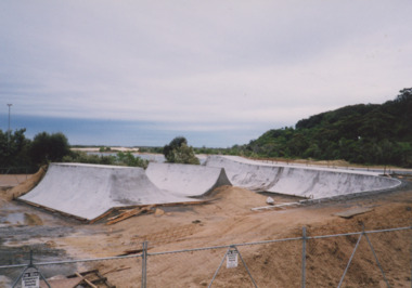
Photograph - Skate Park, Lakes Post Newspaper, 2000
... Colour photograph showing progress of the Skate Park under construction, four concrete installations in place. ...Lakes Entrance Historical Society 4 Marine Parade Lakes Entrance gippsland number in album 03585.01 Construction Sporting facilities Colour photograph showing progress of the Skate Park under construction, four concrete installations in place. ...number in album 03585.01Colour photograph showing progress of the Skate Park under construction, four concrete installations in place. Lakes Entrance Victoriaconstruction, sporting facilities -
 Greensborough Historical Society
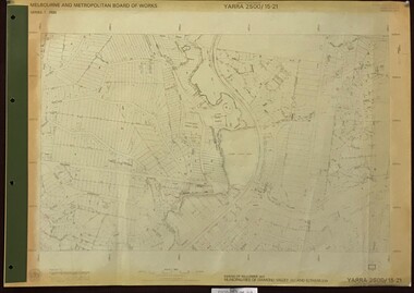
Map, Melbourne and Metropolitan Board of Works. Survey Division, MMBW, Yarra 2500 / 15.21. Eltham North, 1979_08
... Prominent streets include: Progress Road, Glen Park Road and Zig Zag Road. Features include the Diamond Creek, Eltham Council Pound and Eltham North Reserve....Prominent streets include: Progress Road, Glen Park Road and Zig Zag Road. Features include the Diamond Creek, Eltham Council Pound and Eltham North Reserve. mmbw melbourne and metropolitan board of works shire of diamond valley nillumbik eltham - maps MMBW Map in 1:2500 [scale] series. ...Melbourne and Metropolitan Board of Works. Yarra 2500 [base map] 15.21. Eltham North. Parish of Nillumbik 3310. Municipalities of Diamond Valley 257 and Eltham 238. Prominent streets include: Progress Road, Glen Park Road and Zig Zag Road. Features include the Diamond Creek, Eltham Council Pound and Eltham North Reserve.MMBW Map in 1:2500 [scale] series. Cream parchment with green tape reinforcing on edges and punched holes on left edge.mmbw, melbourne and metropolitan board of works, shire of diamond valley, nillumbik, eltham - maps -
 Greensborough Historical Society
Newsletter, Greenhills and North Greensborough Progress Association, Community News: official journal of the Greenhills and Nth. Greensborough Progress Association. 5th September, 1975, 05/09/1975
... This edition includes a report on the Progress Association's meeting, A park close to the heart of Greensborough, From the Council Chamber, The Plenty Gorge : can our region's major landscape resource survive? ...Greensborough Historical Society 34A Glenauburn Road Lower Plenty Lower Plenty melbourne This edition includes a report on the Progress Association's meeting, A park close to the heart of Greensborough, From the Council Chamber, The Plenty Gorge : can our region's major landscape resource survive? ...This edition includes a report on the Progress Association's meeting, A park close to the heart of Greensborough, From the Council Chamber, The Plenty Gorge : can our region's major landscape resource survive? A digital copy of this Newsletter is available from Greensborough Historical Society.Newsletter, 4 p., illus.greenhills and north greensborough progress association, greenhills -
 Sunshine and District Historical Society Incorporated
Administrative record - Albion Tennis Club - Submission by The Albion Tennis Club to The Sports Advisory Committee of the Sunshine City Council, C1975
... Submission by The Albion Tennis Club to The Sports Advisory Committee of the Sunshine City Council Summary - Summary of the club's activity since moving to Selwyn Park History of the club - Short history of the club since formation in King Edward Avenuee to moving to Selwyn Park Progress since relocation to Selwyn Park - Use of the Selwyn Park House as the club's clubhouse What we propose - Build a new clubhouse & landscape the area Plans and Estimates...This item was part of the John Willaton's Albion Tennis Club Collection Albion Tennis Club Tennis Selwyn Park Selwyn Street Albion Submission by The Albion Tennis Club to The Sports Advisory Committee of the Sunshine City Council Summary - Summary of the club's activity since moving to Selwyn Park History of the club - Short history of the club since formation in King Edward Avenuee to moving to Selwyn Park Progress since relocation to Selwyn Park - Use of the Selwyn Park House as the club's clubhouse What we propose - Build a new clubhouse & landscape the area Plans and Estimates Typed document Administrative record Albion Tennis Club - Submission by The Albion Tennis Club to The Sports Advisory Committee of the Sunshine City Council ...This item was part of the John Willaton's Albion Tennis Club CollectionSubmission by The Albion Tennis Club to The Sports Advisory Committee of the Sunshine City Council Summary - Summary of the club's activity since moving to Selwyn Park History of the club - Short history of the club since formation in King Edward Avenuee to moving to Selwyn Park Progress since relocation to Selwyn Park - Use of the Selwyn Park House as the club's clubhouse What we propose - Build a new clubhouse & landscape the area Plans and Estimatesalbion tennis club, tennis, selwyn park, selwyn street, albion -
 Emerald Museum & Nobelius Heritage Park
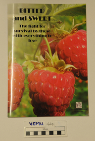
Book, Bitter and Sweet - The fight for survival by those with everything to lose by Monbulk Historical Society, 2016
... Emerald Museum & Nobelius Heritage Park 5 Crichton Rd Emerald yarra-valley-and-the-dandenong-ranges This book focuses on the minute books of the Monbulk Progress and Fruit Growers Association from 16 October 1918 and explores the background to, and the significant issues and events reflected in the minutes eg. industrial relations, transport, marketing and corruption. ...This book focuses on the minute books of the Monbulk Progress and Fruit Growers Association from 16 October 1918 and explores the background to, and the significant issues and events reflected in the minutes eg. industrial relations, transport, marketing and corruption. The memoirs of George A'Vard relate his experiences in growing and carting raspberries.Soft cover bookmonbulk historical society, monbulk progress and fruit growers association, george a'vard -
 Emerald Museum & Nobelius Heritage Park
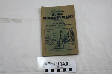
Book, Whitcombes Human Geography Reader Grade V. Australia It's People and Progress, 3rd Edition Revised, After 1940s
... Emerald Museum & Nobelius Heritage Park 5 Crichton Rd Emerald yarra-valley-and-the-dandenong-ranges "Specially written to meet the requirements of the social studies (Geography) course in Victorian elementary schools." Whitcombe's Human Geography Reader Grade V Paperback book with light cardboard cover. Whitcombes Human Geography Reader Grade V. Australia It's People and Progress ..."Specially written to meet the requirements of the social studies (Geography) course in Victorian elementary schools."Paperback book with light cardboard cover.whitcombe's human geography reader grade v -
Marysville & District Historical Society... park precinct...triangle garden club...marysville primary school parents club agm...town meeting narbethong community hall...narbethong progress...Marysville & District Historical Society 39 Darwin Street Marysville yarra-valley-and-the-dandenong-ranges marysville victoria australia murrindindi shire heritage study adopted marysville tree works what's on when in march the committee of management of the gallipoli park precinct triangle garden club marysville primary school parents club agm town meeting narbethong community hall narbethong progress assocn villains player registration day preparing for easter 2012 church notices mops agm marysville preschool duck race el kanah's open weekend advertisements adventurous cooks kim's kitchen closed marysville pharmacy the 3 tenors show breast screening mobile service mayor's chair historic bridge saved murrindindi shire council breakaway bridge marysville & district sesquicentenary celebrations villains 2012 season launch services review community information sessions marysville golf report marysville real estate long lunch undercover taggerty trail under review grand opening labour day weekend maryton park b & b madrats lake mountain music festival ...marysville, victoria, australia, murrindindi shire heritage study adopted, marysville tree works, what's on when in march, the committee of management of the gallipoli park precinct, triangle garden club, marysville primary school parents club agm, town meeting narbethong community hall, narbethong progress assocn, villains player registration day, preparing for easter 2012, church notices, mops agm, marysville preschool duck race, el kanah's open weekend, advertisements, adventurous cooks, kim's kitchen closed, marysville pharmacy, the 3 tenors show, breast screening mobile service, mayor's chair, historic bridge saved, murrindindi shire council, breakaway bridge, marysville & district sesquicentenary celebrations, villains 2012 season launch, services review community information sessions, marysville golf report, marysville real estate, long lunch undercover, taggerty trail under review, grand opening labour day weekend, maryton park b & b, madrats, lake mountain music festival
-
Marysville & District Historical Society
THE TRIANGLE NEWS-VOL 39 NO 24-JUNE 29 2012
... park precinct...intrepid triangle bushwalkers...creative triangle...marysville & triangle youth group...local residents honoured at 2021 queen's birthday...advertisements...marysville cricket club agm...marsyville fire station...church notices...christmas in july community dinner...marysville golf club...men's breakfast...igloo roadhouse...taggerty community progress...Marysville & District Historical Society 39 Darwin Street Marysville yarra-valley-and-the-dandenong-ranges marysville victoria australia lions club changeover dinner friends of lions men's shed works start what's on when in july crafters circle craft day narbethong hall the committee of management of the gallipoli park precinct intrepid triangle bushwalkers creative triangle marysville & triangle youth group local residents honoured at 2021 queen's birthday advertisements marysville cricket club agm marsyville fire station church notices christmas in july community dinner marysville golf club men's breakfast igloo roadhouse taggerty community progress group taggerty hall committee marysville primary school artists in the acheron marysville villains football marysville pharmacy marysville medical clinic mayor's chair marysville golf report councillor comment marysville community market murrindindi shire council position vacant real estate works improve yea facilities yea river lake mountain alpine resort works to improve break o'day road THE TRIANGLE NEWS-VOL 39 NO 24-JUNE 29 2012 ...marysville, victoria, australia, lions club changeover dinner, friends of lions, men's shed works start, what's on when in july, crafters circle, craft day, narbethong hall, the committee of management of the gallipoli park precinct, intrepid triangle bushwalkers, creative triangle, marysville & triangle youth group, local residents honoured at 2021 queen's birthday, advertisements, marysville cricket club agm, marsyville fire station, church notices, christmas in july community dinner, marysville golf club, men's breakfast, igloo roadhouse, taggerty community progress group, taggerty hall committee, marysville primary school, artists in the acheron, marysville villains football, marysville pharmacy, marysville medical clinic, mayor's chair, marysville golf report, councillor comment, marysville community market, murrindindi shire council, position vacant, real estate, works improve yea facilities, yea river, lake mountain alpine resort, works to improve break o'day road -
Marysville & District Historical Society
THE TRIANGLE NEWS-VOL 39 NO 29-AUGUST 3 2012
... park precinct...marysville community market...creative triangle...rating options council wants feedback...murrindindi shire council...men's breakfast...church notices...triangle community dinner...narbethong progress...Marysville & District Historical Society 39 Darwin Street Marysville yarra-valley-and-the-dandenong-ranges marysville victoria australia bendigo bank a driving force in business recovery tom hafey at villains last game what's on when in august the committee of management of the gallipoli park precinct marysville community market creative triangle rating options council wants feedback murrindindi shire council men's breakfast church notices triangle community dinner narbethong progress association yea community bus position vacant adventurous cooks marysville pharmacy marysville medical clinic mayor's chair advertisements salesyard project covering many bases mystic mountain tourism marysville cultural community magician/illusionist real estate marysville golf report notice of proposal to make a local law THE TRIANGLE NEWS-VOL 39 NO 29-AUGUST 3 2012 ...marysville, victoria, australia, bendigo bank a driving force in business recovery, tom hafey at villains last game, what's on when in august, the committee of management of the gallipoli park precinct, marysville community market, creative triangle, rating options council wants feedback, murrindindi shire council, men's breakfast, church notices, triangle community dinner, narbethong progress association, yea community bus, position vacant, adventurous cooks, marysville pharmacy, marysville medical clinic, mayor's chair, advertisements, salesyard project covering many bases, mystic mountain tourism, marysville cultural community, magician/illusionist, real estate, marysville golf report, notice of proposal to make a local law -
Marysville & District Historical Society
THE TRIANGLE NEWS-VOL 39 NO 39-OCTOBER 1 2012
... park...murrindindi shire council elections...sustainable gardening at alexandra library...radiothon shows support for ugfm...upper goulburn community radio...victorian concert orchestra...adventurous cooks...narbethong community hall...narbethong progress...Marysville & District Historical Society 39 Darwin Street Marysville yarra-valley-and-the-dandenong-ranges marysville victoria australia marysville sparkling wine festival business breakfast golf day australian sparkling wine show gala awards dinner what's on when in october intrepid triangle bushwalkers marysville community market creative triangle marysville golf report maryton beer & platter garden reopening maryton park b&b buxton primary school church notices fire season-slashing program aged and disability services advertisements narbethong community garage sale steavenson falls floodlighting returns completion of the recovery project gallipoli park murrindindi shire council elections sustainable gardening at alexandra library radiothon shows support for ugfm upper goulburn community radio victorian concert orchestra adventurous cooks narbethong community hall narbethong progress association buxton hotel car boot sale dalton fiske foundation marysville & district lions project triangle community dancers taggerty hall australia day awards sample wines marysville marathon buxton general store cathedral ward candidates marysville saddle tramps celebrating 30 years gallipoli park community centre dinner and jukebox dance roaring 20's alexandra town hall dance THE TRIANGLE NEWS-VOL 39 NO 39-OCTOBER 1 2012 ...marysville, victoria, australia, marysville sparkling wine festival, business breakfast, golf day, australian sparkling wine show, gala awards dinner, what's on when in october, intrepid triangle bushwalkers, marysville community market, creative triangle, marysville golf report, maryton beer & platter garden reopening, maryton park b&b, buxton primary school, church notices, fire season-slashing program, aged and disability services, advertisements, narbethong community garage sale, steavenson falls floodlighting returns, completion of the recovery project, gallipoli park, murrindindi shire council elections, sustainable gardening at alexandra library, radiothon shows support for ugfm, upper goulburn community radio, victorian concert orchestra, adventurous cooks, narbethong community hall, narbethong progress association, buxton hotel, car boot sale, dalton fiske foundation, marysville & district lions project, triangle community dancers, taggerty hall, australia day awards, sample wines, marysville marathon, buxton general store, cathedral ward candidates, marysville saddle tramps celebrating 30 years, gallipoli park community centre, dinner and jukebox dance, roaring 20's alexandra town hall dance -
Marysville & District Historical Society
THE TRIANGLE NEWS-VOL 39 NO 40-OCTOBER 19 2012
... park...marysville primary school...parents club trivia night...black spur hotel...victorian concert orchestra...narbethong community hall...narbethong progress...Marysville & District Historical Society 39 Darwin Street Marysville yarra-valley-and-the-dandenong-ranges marysville victoria australia open gardens in buxton taggerty and acheron what's on when in october advertisements triangle community dinner marysville golf club marysville district cricket club annual duck race marysville art show church notices parish luncheon saladin lodge fire season-slashing program marysville golf report maryton beer & platter garden reopening maryton park b & b following the legend of archer the race horse country touch news australia day awards sample wines marysville marathon narbethong community garage sale cartwheels festival alexandra secondary college dalton fiske foundation triangle community dancers taggerty hall real estate steavenson falls flood lighting returns completion of recovery project gallipoli park marysville primary school parents club trivia night black spur hotel victorian concert orchestra narbethong community hall narbethong progress association buxton hotel carboot sale cathedral ward candidates murrindindi shire council elections memorial designs to engage community healing journey marysville saddle tramps celebrating 30 years gallipoli park community centre THE TRIANGLE NEWS-VOL 39 NO 40-OCTOBER 19 2012 ...marysville, victoria, australia, open gardens in buxton taggerty and acheron, what's on when in october, advertisements, triangle community dinner, marysville golf club, marysville district cricket club, annual duck race, marysville art show, church notices, parish luncheon, saladin lodge, fire season-slashing program, marysville golf report, maryton beer & platter garden reopening, maryton park b & b, following the legend of archer the race horse, country touch news, australia day awards, sample wines, marysville marathon, narbethong community garage sale, cartwheels festival alexandra secondary college, dalton fiske foundation, triangle community dancers, taggerty hall, real estate, steavenson falls flood lighting returns, completion of recovery project, gallipoli park, marysville primary school, parents club trivia night, black spur hotel, victorian concert orchestra, narbethong community hall, narbethong progress association, buxton hotel, carboot sale, cathedral ward candidates, murrindindi shire council elections, memorial designs to engage community healing journey, marysville saddle tramps celebrating 30 years, gallipoli park community centre -
Marysville & District Historical Society
THE TRIANGLE NEWS-VOL 39 NO 44-NOVEMBER 16 2012
... progress assocn...new rose garden for lions park...Marysville & District Historical Society 39 Darwin Street Marysville yarra-valley-and-the-dandenong-ranges marysville victoria australia marysville art show winners what's on when in november friends of the marysville walkers agm narbethong community hall agm marysville & district kindergarten assocn preschool centre creative triangle marysville community market licola camps black spur roadhouse melbourne concert orchestra comes to narbethong narbethong progress assocn new rose garden for lions park lions of marysville & district church notices carols by candlelight gallipoli park marysville golf report triangle garden club tennis at buxton marysville cricket club training australia day nominations extended australia day awards marysville district football & netball club camp marysville vicforests help children outdoor education group advertisements mayor's chair snakes fight for mating rights department of sustainability and environment swimming pool entry & season tickets triangle community dancers movember at marysville golf club prepare of australia day real estate shortlist of bushfire memorial sites intrepid triangle bushwalkers key community projects in toolangi and castella bridge takes shape at yellow creek taggerty vicforests help gardens rise from black saturday murrindindi shire pools taggerty xmas party request for tender marysville & triangle tourism interpretive product murrindindi climate network new vibe hotel and conference centre cfa sunday buxton fire station buxton home for private sale THE TRIANGLE NEWS-VOL 39 NO 44-NOVEMBER 16 2012 ...marysville, victoria, australia, marysville art show winners, what's on when in november, friends of the marysville walkers agm, narbethong community hall agm, marysville & district kindergarten assocn preschool centre, creative triangle, marysville community market, licola camps, black spur roadhouse, melbourne concert orchestra comes to narbethong, narbethong progress assocn, new rose garden for lions park, lions of marysville & district, church notices, carols by candlelight, gallipoli park, marysville golf report, triangle garden club, tennis at buxton, marysville cricket club training, australia day nominations extended, australia day awards, marysville district football & netball club, camp marysville, vicforests help children, outdoor education group, advertisements, mayor's chair, snakes fight for mating rights, department of sustainability and environment, swimming pool entry & season tickets, triangle community dancers, movember at marysville golf club, prepare of australia day, real estate, shortlist of bushfire memorial sites, intrepid triangle bushwalkers, key community projects in toolangi and castella, bridge takes shape at yellow creek taggerty, vicforests help gardens rise from black saturday, murrindindi shire pools, taggerty xmas party, request for tender, marysville & triangle tourism interpretive product, murrindindi climate network, new vibe hotel and conference centre, cfa sunday, buxton fire station, buxton home for private sale -
Marysville & District Historical Society
THE TRIANGLE NEWS-VOL 5 NO 35-NOVEMBER 7 1980
... park...church anglican...church uniting...marysville newsagency...think it over...senior citizens...stall...fire brigade...farewell...s.e.s....community care centre...football club...lost...marysville tourist & progress...Marysville & District Historical Society 39 Darwin Street Marysville yarra-valley-and-the-dandenong-ranges marysville victoria australia for sale marysville lions club s.e.s congratulations wirreanda wirrianda appaloosa stud happy birthday kinder roster annual toy & book display maryton park church anglican church uniting marysville newsagency think it over senior citizens stall fire brigade farewell s.e.s. community care centre football club lost marysville tourist & progress association corner shop tennis engagement marysville primary school found craft shop golf associates THE TRIANGLE NEWS-VOL 5 NO 35-NOVEMBER 7 1980 ...marysville, victoria, australia, for sale, marysville lions club, s.e.s, congratulations, wirreanda, wirrianda appaloosa stud, happy birthday, kinder roster, annual toy & book display, maryton park, church anglican, church uniting, marysville newsagency, think it over, senior citizens, stall, fire brigade, farewell, s.e.s., community care centre, football club, lost, marysville tourist & progress association, corner shop, tennis, engagement, marysville primary school, found, craft shop, golf associates -
Marysville & District Historical Society
THE TRIANGLE NEWS-VOL 35 NO 2-JANUARY 25 2008
... park...uppbeats band...buxton hall...the elderly bros band...diary dates...deadline...advertising rates...flags...australia day parade...buxton progress...Marysville & District Historical Society 39 Darwin Street Marysville yarra-valley-and-the-dandenong-ranges marysville victoria australia marysville australia day lions park uppbeats band buxton hall the elderly bros band diary dates deadline advertising rates flags australia day parade buxton progress assocn murrindindi shire council ceo visiting schedule disclaimer fire calls terra cotta room regional food & wine centre marysville village walk mops church notices marysville under 12 cricket marysville start school dates best decorated bike thank you bendigo bank marysville medical clinic bible quote community kitchens advertisements mayor's chair paradise bead & craft centre wirreanda festival 2008 marysville & district historical society automotive needs public notice temporary road closure australia day mystic mountains outdoors community health services outreach services murrindindi business development calendar community events employing people workshop wilks creek & andersons sawmills alexandra clearance sale for sale real estate THE TRIANGLE NEWS-VOL 35 NO 2-JANUARY 25 2008 ...marysville, victoria, australia, marysville australia day, lions park, uppbeats band, buxton hall, the elderly bros band, diary dates, deadline, advertising rates, flags, australia day parade, buxton progress assocn, murrindindi shire council, ceo visiting schedule, disclaimer, fire calls, terra cotta room, regional food & wine centre, marysville village walk, mops, church notices, marysville under 12 cricket, marysville start school dates, best decorated bike, thank you bendigo bank, marysville medical clinic, bible quote, community kitchens, advertisements, mayor's chair, paradise bead & craft centre, wirreanda festival 2008, marysville & district historical society, automotive needs, public notice, temporary road closure australia day, mystic mountains outdoors, community health services, outreach services, murrindindi business development calendar, community events, employing people workshop, wilks creek & andersons sawmills, alexandra clearance sale, for sale, real estate -
Marysville & District Historical Society
THE TRIANGLE NEWS-VOL 36 NO 37-OCTOBER 2 2009
... park...your health and wellbeing...public notice...rural 1 land...buxton progress...Marysville & District Historical Society 39 Darwin Street Marysville yarra-valley-and-the-dandenong-ranges marysville victoria australia late snow still an attraction marysville marathon dr lachlan fraser what's on when in october buxton cfa buxton community hall annual buxton community christmas bbq buxton reserve football in marysville the marysville & district lions club mtcrc report advertisements marysville marquee mobile kitchens my chef mike catering st michael's grammar school all stars band bpa news had enough community support gathering marysville golf club accredited facilitators graeme & julia cann church notices vale christina barton charcoal drawings of christ church and marysville primary school situations vacant waste transfer station community service hub operating hours spring-season of hope and promise marysville medical clinic councillor comment bushfire affected residents to reap solar hot water rebate marysville art show marysville & district football & netball clubs lakeside fellowship evening eildon community centre hall alexandra cinema murrindindi shire council youth development and participation officer mayors chair marysville community market gallipoli park lions triangle tool library marysville community golf & bowls club marysville caravan park your health and wellbeing public notice rural 1 land buxton progress assocn amnesty period on open air burning marysville junior cricket marysville triangle real estate alexandra clearing sale THE TRIANGLE NEWS-VOL 36 NO 37-OCTOBER 2 2009 ...marysville, victoria, australia, late snow still an attraction, marysville marathon, dr lachlan fraser, what's on when in october, buxton cfa, buxton community hall, annual buxton community christmas bbq, buxton reserve, football in marysville, the marysville & district lions club, mtcrc report, advertisements, marysville marquee, mobile kitchens, my chef mike catering, st michael's grammar school all stars band, bpa news, had enough community support gathering, marysville golf club, accredited facilitators graeme & julia cann, church notices, vale christina barton, charcoal drawings of christ church and marysville primary school, situations vacant, waste transfer station, community service hub operating hours, spring-season of hope and promise, marysville medical clinic, councillor comment, bushfire affected residents to reap solar hot water rebate, marysville art show, marysville & district football & netball clubs, lakeside fellowship evening, eildon community centre hall, alexandra cinema, murrindindi shire council, youth development and participation officer, mayors chair, marysville community market, gallipoli park, lions triangle tool library, marysville community golf & bowls club, marysville caravan park, your health and wellbeing, public notice, rural 1 land, buxton progress assocn, amnesty period on open air burning, marysville junior cricket, marysville triangle real estate, alexandra clearing sale -
Marysville & District Historical Society
THE TRIANGLE NEWS-VOL 37 NO 30-AUGUST 20 2010
... park committee of management...buxton tv tower...buxton progress...Marysville & District Historical Society 39 Darwin Street Marysville yarra-valley-and-the-dandenong-ranges marysville victoria australia animals aid after black saturday alpacas building communities through recovery fund advertisements rebuilding bees after fires mayor's message gallipoli park committee of management buxton tv tower buxton progress assocn THE TRIANGLE NEWS-VOL 37 NO 30-AUGUST 20 2010 ...marysville, victoria, australia, animals aid after black saturday, alpacas, building communities through recovery fund, advertisements, rebuilding bees after fires, mayor's message, gallipoli park committee of management, buxton tv tower, buxton progress assocn -
Marysville & District Historical Society
THE TRIANGLE NEWS-VOL 38 NO 9-MARCH 18 2011
... park...footy progress at marysville...Marysville & District Historical Society 39 Darwin Street Marysville yarra-valley-and-the-dandenong-ranges marysville victoria australia marysville bowlers & golf club win murchison street new technology advertisements marysville construction update gallipoli park footy progress at marysville alexandra library THE TRIANGLE NEWS-VOL 38 NO 9-MARCH 18 2011 ...marysville, victoria, australia, marysville bowlers & golf club win, murchison street new technology, advertisements, marysville construction update, gallipoli park, footy progress at marysville, alexandra library -
Marysville & District Historical Society
THE TRIANGLE NEWS-VOL 38 NO 30-AUGUST 26 2011
... park...mary meadows track...horse riding...marysville saddle tramps...wilkes creek...australian lions children's mobility foundation...hart walker...lions work with community...notice to residents...roadwork activities...church notices...buxton progress...Marysville & District Historical Society 39 Darwin Street Marysville yarra-valley-and-the-dandenong-ranges marysville victoria australia bravery honours governor general quentin bryce australian bravery decorations black saturday bushfires gallipoli park mary meadows track horse riding marysville saddle tramps wilkes creek australian lions children's mobility foundation hart walker lions work with community notice to residents roadwork activities church notices buxton progress assocn mops THE TRIANGLE NEWS-VOL 38 NO 30-AUGUST 26 2011 ...marysville, victoria, australia, bravery honours, governor general quentin bryce, australian bravery decorations, black saturday bushfires, gallipoli park, mary meadows track, horse riding, marysville saddle tramps, wilkes creek, australian lions children's mobility foundation, hart walker, lions work with community, notice to residents, roadwork activities, church notices, buxton progress assocn, mops -
 Eltham District Historical Society Inc
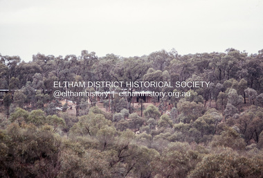
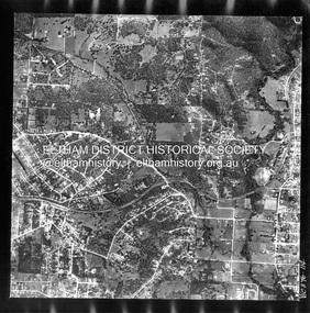
Photograph - Aerial Photograph, Landata, Montmorency, Feb. 1956
... Park...Eltham...leach street...Main Road...Melway 21F5...Montmorency...Progress...Progress Road to north, Withers Way to south, Main Road to east and Leach Street to west. Historic Aerial Imagery Source: Landata.vic.gov.au Aerial Photo Details: Project No :250 Project : MELBOURNE OUTER SUBURBS PROJECT Run : 17 Frame : 114 Date : 02/1956 Film Type : B/W Camera : EAG9 Flying Height : 10000 Scale : 12000 Film Number : 1176 GDA2020 : 37°42'50"S, 145°08'02"E MGA2020 : 335512, 5824286 (55) Melways : 21 F5 (ed. 42) Aerial Photo 1956-02 Neil Webster Collection Central Park Eltham leach street Main Road Melway 21F5 Montmorency Progress Road Withers Way Sherbourne Preschool Tahlee Place Reserve Digital jpg and electronic PDF file Montmorency Photograph Aerial Photograph Landata ...Centred on present day Tahlee Place Reserve and Sherbourne Preschool, Montmorency bounded by Progress Road to north, Withers Way to south, Main Road to east and Leach Street to west. Historic Aerial Imagery Source: Landata.vic.gov.au Aerial Photo Details: Project No :250 Project : MELBOURNE OUTER SUBURBS PROJECT Run : 17 Frame : 114 Date : 02/1956 Film Type : B/W Camera : EAG9 Flying Height : 10000 Scale : 12000 Film Number : 1176 GDA2020 : 37°42'50"S, 145°08'02"E MGA2020 : 335512, 5824286 (55) Melways : 21 F5 (ed. 42)aerial photo, 1956-02, neil webster collection, central park, eltham, leach street, main road, melway 21f5, montmorency, progress road, withers way, sherbourne preschool, tahlee place reserve -
 Eltham District Historical Society Inc
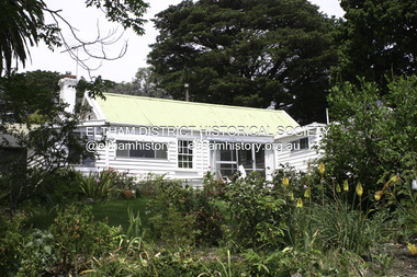
Photograph - Digital Photograph, Alan King, Garden Hill, Eltham-Yarra Glen Road, Kangaroo Ground, 3 February 2008
... Park near Melbourne. Gepp was a pioneer in applying enlightened labour policies in industry. He initiated the Broken Hill Progress Association, to improve living conditions. ...Park near Melbourne. Gepp was a pioneer in applying enlightened labour policies in industry. He initiated the Broken Hill Progress Association, to improve living conditions. ...The original house was built around 1850 was one of Kangaroo Ground's earliest homes, part of which remains today. Built by Scottish farmer Andrew Harkness who acquired the property in 1849 at the top of the hill with magnificent panoramic views as far as Kinglake, the same year he married Sarah Oswin. The property was known as Garden Hill from at least 1865. Andrew and Sarah had four sons and five daughters. Harkness was a founder of the Kangaroo Ground School and one of the first to suggest establishing the Eltham District Road Board (1858-71) of which he was a member, the pre-cursor to the Shire of Eltham (1871-1994). He was also a Trustee of the Kangaroo Ground Cemetery. His daughter Fanny married farmer Alexander White who purchased the property in 1893. Alexander White died in 1906 and ownership transferred to Fanny White. Son, Robert White was a Councillor of the Shire of Eltham at the time the Shire acquired two acres of land on the adjacent property from the Mess brothers for the creation of the Shire of Eltham Memorial Park (1921) in which the Shire of Eltham War Memoirial tower was erected (1926). Fanny White donated a small section of land from the Garden Hill property to facilitate entry access to the park. The White family sold the property to Sir Herbert Gepp in 1925. Covered under Heritage Overlay, Nillumbik Planning Scheme. Published: Nillumbik Now and Then / Marguerite Marshall 2008; photographs Alan King with Marguerite Marshall.; p29 Garden Hill, on Yarra Glen Road, Kangaroo Ground, near the War Memorial is well named. The old house and gardens overlook a magnificent panorama extending to Kinglake. The original house, built around 1850, was one of Kangaroo Ground’s earliest, and part of it remains in today’s timber house. The house was built by the early and prominent settler Andrew Harkness. Later it was occupied for a long time by Sir Herbert Gepp, renowned Australia wide.1 Harkness and Gepp are buried in the Kangaroo Ground Cemetery. Scottish farmer Harkness, who was born in 1817, acquired this property in 18492 and he and his family occupied it until the early 1920s. Harkness cleared its 152 acres (61.4 ha), fenced it and grazed sheep and cattle. Harkness proved a valuable community member. When only ten families lived in the district, he and other settlers set up a school in 1852, with Andrew Ross as the first teacher. Harkness was also one of the first to suggest establishing the Eltham District Road Board, of which he was a member for around 15 years. He was also a trustee of the Kangaroo Ground Cemetery. Harkness married in 1854 and had four sons and five daughters. The first part of the timber house he built included a kitchen-living room and a parlor. The living room’s large fireplace was bricked-in and modernised in 1940. Beside it is the old baker’s oven with its original iron door replaced by a wooden one. It is thought two wattle-and-daub huts, used for a bedroom and bathroom, were built to the west. Harkness’ son-in-law, farmer Alexander White, who had seven sons, bought the property in 1893. Harkness’ grand-daughter Flora married Ewen Cameron who became Minister for Health and was later knighted; he was not related to Ewen Hugh Cameron, a Member of the Legislative Assembly. In 1923 the White family sold the property, called Kilby Park, to Sir Herbert Gepp, who renamed it Garden Hill. Gepp used the property, which was still on the original New South Wales title, as a hobby farm. Robert White stayed on to manage the farm for a while, living in a house on the property. Gepp was born in 1877 and at 16 years began working as a junior chemist with the Australian Explosives and Chemical Company at Deer Park near Melbourne. Gepp was a pioneer in applying enlightened labour policies in industry. He initiated the Broken Hill Progress Association, to improve living conditions. It laid the ground work for the welfare schemes pursued by companies after World War One. During the mid 20th century Gepp was the most prominent liberal thinker associated with conservative politics. As a friend of Prime Minister John Curtin, he contributed to post-war reconstruction. Gepp returned to private industry and retired in 1950. Gepp made significant contributions to the solution of the great metallurgical problems of the mining industry. He was an advocate of the role of science in industry, government and the economy and helped to establish several organizations including the CSIR and the Institute of Public Affairs.3 After Sir Herbert died in 1954 his son Orwell continued to farm the property part-time. When Lady Gepp died in 1963, the land was divided among the five children, although Orwell continued to farm it as a hobby. In 1966, a daughter, Mardi Gething, now married, settled in the house. Another daughter, Kathleen, built her house close by on the property. After the Board of Works designated the property as part of a reserve for a possible reservoir, the family sold all, except the minimum 20 acres allowed, to the Board in the 1970s. Orwell then leased what was the family property from the Board to continue grazing. The two sisters and brother continued to live on the property.This collection of almost 130 photos about places and people within the Shire of Nillumbik, an urban and rural municipality in Melbourne's north, contributes to an understanding of the history of the Shire. Published in 2008 immediately prior to the Black Saturday bushfires of February 7, 2009, it documents sites that were impacted, and in some cases destroyed by the fires. It includes photographs taken especially for the publication, creating a unique time capsule representing the Shire in the early 21st century. It remains the most recent comprehenesive publication devoted to the Shire's history connecting local residents to the past. nillumbik now and then (marshall-king) collection, kangaroo ground -
 Eltham District Historical Society Inc
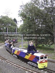
Photograph - Digital Photograph, Marguerite Marshall, Diamond Valley Railway, Eltham Lower Park, 7 September 2008
... Park in 1959. The railway is modelled on the 1920s era – the heyday of passenger rail travel – and the trains are built on a scale of two inches to the foot (1/6). Although not exact replicas, trains include models of the Spirit of Progress...Park in 1959. The railway is modelled on the 1920s era – the heyday of passenger rail travel – and the trains are built on a scale of two inches to the foot (1/6). Although not exact replicas, trains include models of the Spirit of Progress ...Kids of all ages enjoy the Miniature Railway. Published: Nillumbik Now and Then / Marguerite Marshall 2008; photographs Alan King with Marguerite Marshall.; p163 On Sundays in Eltham thousands of children, mums, dads and grandparents can be seen travelling around Lower Eltham Park in tiny trains. They are among the two and half million passengers who have travelled on the Diamond Valley Railway since it officially began in 1961. The miniature railway originally operated from the 1940s at Chelsworth Park, Ivanhoe, until flooding caused it to be moved to the Eltham Lower Park in 1959. The railway is modelled on the 1920s era – the heyday of passenger rail travel – and the trains are built on a scale of two inches to the foot (1/6). Although not exact replicas, trains include models of the Spirit of Progress, Puffing Billy, The Overland, Dog Boxes, Vic Rail S class, G class and a NSW 81 Class. The three and a half kilometres of track is set amongst native plants and picnic areas. A friendly hoot or the clang of a bell occasionally punctuates the tranquillity as a train emerges from a treed bend with passengers excitedly waving to onlookers. For $3 the train takes you on a 13-minute two-kilometre ride. Passengers sit in single file in the narrow train, which clatters along tracks built to the scale of the Australian narrow gauge of three feet six inches (1.1m). These are used in Queensland, South Australia, Tasmania and Western Australia. Safety standards are stringently kept. Even before you buy a ticket notices tell you that you must wear closed shoes. You can even borrow these, and you are given a pair of socks for the ride! Blue-overalled volunteers check tickets, see you aboard, and drive the train. They are mainly retired men who can at last devote their time to what little boys dream of – playing with trains. Passengers are instructed in safe behaviour, then the station master waves a white flag and off we go. The guard sits at the back with his whistle and green flag at the ready. The winding track, fringed by native trees and bushes planted by volunteers, stands on crown land managed by Nillumbik Council. The train clatters along the track and crosses a bridge over a drain elevated by name to The Blow Fly Creek. We pass by Meadmore Junction at a speed of three kilometres an hour. Then on through a tunnel, accompanied by squeals of delight, and after a few moments of blackness, light glimmers at the end. On we go, past the original platform, along another route past busy Main Road through Pine Creek Station, over a bridge and through another tunnel with more screams of delight.Then a signal stops us before the ‘all clear’ to return to our original point of departure. The railway services its passengers – the largest number of any miniature railway in Australia – with a fleet including: six diesel locomotives, three steam locomotives, eight sets of passenger cars and one battery electric Dog Box set. Members also privately own 20 locomotives and powered carriage sets as well as four carriage sets.1 All the trains are stored on-site in workshops, sheds and a tunnel. The railway is entirely run by volunteers, so that all ticket money is used for maintenance and extensions, and some goes to local charities. Since 1991, the entire railway has been rebuilt, including an upgraded signalling system. About half of the 120 volunteer members are active with about 35 working each Sunday, and a dozen or so working every Wednesday. Members are trained to positions of station assistant, booking officer, train guard, train driver or signalman. Members construct new carriages and locomotives as well as maintaining track, signalling and rolling stock.This collection of almost 130 photos about places and people within the Shire of Nillumbik, an urban and rural municipality in Melbourne's north, contributes to an understanding of the history of the Shire. Published in 2008 immediately prior to the Black Saturday bushfires of February 7, 2009, it documents sites that were impacted, and in some cases destroyed by the fires. It includes photographs taken especially for the publication, creating a unique time capsule representing the Shire in the early 21st century. It remains the most recent comprehenesive publication devoted to the Shire's history connecting local residents to the past. nillumbik now and then (marshall-king) collection, diamond valley railway, eltham lower park -
 Eltham District Historical Society Inc
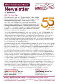
Journal - Newsletter, Newsletter, No. 264 June 2022, Jun 2022
... Contents: • Fifty Five Years Ago • Our Next Meeting – 2.00pm Saturday 11th June 2022 • Heritage Excursion – Saturday 2nd July - Eltham Lower Park – Walk and Talk • Those Wild Aqueduct Days • How the Wheel Turns . . . Sometimes by Jim Connor • Eltham Progressing – 1925 • Unusual Requests? ...Eltham District Historical Society Inc 728 Main Rd Eltham melbourne Contents: • Fifty Five Years Ago • Our Next Meeting – 2.00pm Saturday 11th June 2022 • Heritage Excursion – Saturday 2nd July - Eltham Lower Park – Walk and Talk • Those Wild Aqueduct Days • How the Wheel Turns . . . Sometimes by Jim Connor • Eltham Progressing – 1925 • Unusual Requests? ...Contents: • Fifty Five Years Ago • Our Next Meeting – 2.00pm Saturday 11th June 2022 • Heritage Excursion – Saturday 2nd July - Eltham Lower Park – Walk and Talk • Those Wild Aqueduct Days • How the Wheel Turns . . . Sometimes by Jim Connor • Eltham Progressing – 1925 • Unusual Requests? By Jim Connor • Drownings in the Aqueduct by Richard Pinn • Register of Significant Trees by Jim Connor • Eltham Cemetery Stories by Liz Pidgeon o Memorial to Stillborn Babies • Annual General Meeting –Saturday 23rd April 2022 • SubscriptionsThe Shire of Eltham Historical Society was formed in October 1967. The first newsletter of the Society was issued May 1978 and has been published continuously ever since on a bi-monthly basis. With the cessation of the Shire of Eltham in late 1994, the Society's name was revised to Eltham District Historical Society and this name first appeared with issue No. 103, July 1995. The collection of the Society's newsletters provides a valuable resource on the history of the Society's activities, office bearers and committee members, guest speakers and subjects of historical interest pertinent to the former Shire of Eltham and the Eltham District.A4 newsletter distributed to members (Digital and A4 photocopy)newsletter, eltham district historical society -
 Glen Eira Historical Society
Photograph - CARNEGIE
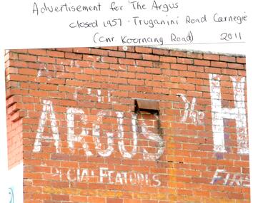
... progress... Newspapers... Temminghoff Robert... Carnegie Chamber of Commerce... Caulfield City Council... Rob’s Chocolate Box... Rosstown... Ross William Murray... Rosstown Railway... Elsternwick... Oakleigh... City of Caulfield... Glen Huntly Road... Glenhuntly Road... Grange Road... Carnegie Primary School... Primary schools... Murrumbeena... Neerim Road... Dandenong Road... Koornang Park...Tranmere Avenue Carnegie Railway Station Stations Libraries Post Offices Memorial Hall Carnegie Progress Hall Carnegie Community Singing Social clubs Chadstone progress Newspapers Temminghoff Robert Carnegie Chamber of Commerce Caulfield City Council Rob’s Chocolate Box Rosstown Ross William Murray Rosstown Railway Elsternwick Oakleigh City of Caulfield Glen Huntly Road Glenhuntly Road Grange Road Carnegie Primary School Primary schools Murrumbeena Neerim Road Dandenong Road Koornang Park Lord Reserve Rosanna Street Reserve Packer Oval Reserve Caulfield Swim Centre Holywood Grove Mile End Road McPherson Avenue Munster Avenue Rosstown Hotel Leila Road Methodist Church Toolambool Street Carnegie Theatre Carnegie Estate Agency – Sims and Broadbent Woorayl Street Estate agents Cowie J. ...24 photographs relating to Carnegie plus 1 slide: 1/Two photographs, one of Koornang Road c.1920’s and one of flower shop rear of library, date unknown. 2/One photograph of Carnegie Post Office c. undated. 3/Two photographs Koornang Road, Carnegie and phone boxes, Carnegie, dated 1914. 4/Two photographs (the same) of an RSL Ball dated 15/08/1937. 5/17 black and white negative photos – reprinted, date unknown, of Carnegie Library, shop front opening Koornang Road. 6/Slide showing Koornang Road, Carnegie looking South. 7/6 photocopied postcards from Valentines Real Photo Series, in album owned by Mrs. Zoe Mason, collected and returned to Pam Speedy (daughter) 12 Wattle Grove, East Malvern, 15/03/1999. Photocopied pages from 1923 Sands and McDougalls included with some prints to give an idea of architecture and other retail trade. 8/Two photocopied prints of Carnegie Flood. 1946 – Koornang Road, shows shopkeepers in street at that time. 9/Two photographs of brick wall advertising the "Argus" newpaper, which closed in 1957. Photos taken in 2011 when building was exposed prior to rebuilding on site.koornang road, rosstown road, carnegie, shepparson street, carnegie library, carnegie post office, mcallister b., glen huntly, glenhuntly, phone boxes, memorial hall, bamfield m., tranmere avenue, carnegie railway station, stations, libraries, post offices, memorial hall carnegie, progress hall, carnegie community singing, social clubs, chadstone progress, newspapers, temminghoff robert, carnegie chamber of commerce, caulfield city council, rob’s chocolate box, rosstown, ross william murray, rosstown railway, elsternwick, oakleigh, city of caulfield, glen huntly road, glenhuntly road, grange road, carnegie primary school, primary schools, murrumbeena, neerim road, dandenong road, koornang park, lord reserve, rosanna street reserve, packer oval reserve, caulfield swim centre, holywood grove, mile end road, mcpherson avenue, munster avenue, rosstown hotel, leila road, methodist church, toolambool street, carnegie theatre, carnegie estate agency – sims and broadbent, woorayl street, estate agents, cowie j. mrs., confectioner, woodhouse e., stationer, mckay jno. a., mckay jonathon, small goods, perry w. b., chemists, kinsman e. h., newsagents, jones a. w., mckee wm., furniture stores, neil geo. m., grocer, truganini road, brick -
Glen Eira Historical Society
Article - MCKINNON
... Progress Association... Glen Orme Avenue... Ormond Theatre... Theatres... Lester Harry... The Plaza... Railway Crossing... Railway Gates... Wright Street... Nichols L.... Builders... Pine Grove... Halls... St. Elmo Estate... Patterson Station Estate... Patterson Road... Brewer Road... Purton Road... Clee Hill Estate... Railway Park...White Horrie Robinson’s McInnerney’s Flower Shop Jean Darling’s Cakes Wyles Jim McKinnon Progress Association Glen Orme Avenue Ormond Theatre Theatres Lester Harry The Plaza Railway Crossing Railway Gates Wright Street Nichols L. Builders Pine Grove Halls St. Elmo Estate Patterson Station Estate Patterson Road Brewer Road Purton Road Clee Hill Estate Railway Park Hawthorn Grove Wattle Grove Elm Grove Learys Estate Manchester Road Selkirk Avenue Masters Estate Lancaster Street Moylan Street Moorabbin Railway Crossing Article MCKINNON ...Brief typed history of McKinnon settlement taken from Moorabbin A Pictorial History 1862-1994 by John Cribben. Includes photocopied pages of railway gates, five land estate flyers and an article from the McKinnon Progress, undated.mckinnon, cribben john, crop production, markets, farmers, elster creek, mcmillan archibald, thomas street, centre road, wheatley road, vineyards, south road, ormond, brighton, moorabbin, irish, immigrants, bentleigh, priests, hanrahan pierce, hanrahan johanna, caroll michael, caroll catherine, howes eliza, howes john, howes edward, shanahan denis, shanahan ellen, gould james, gould catherine, howes george, bignell road, jasper road, tucker road, mcguiness family, quinn family, halinan family, malane family, inns, the gardeners arms, mckinnon hotel, bent james, bent thomas, tickets of leave, murray road, were nicholas, sargood family, ripponlea, mansions, elsternwick, st. stephens’ common school, church of england, school houses, evelyn street, st. john’s anglican church, telegraph offices, post offices, state schools, manchester road, north road, nicholls buildings, rivers frank, rivers ray, shops, pridgeon mr., elm grove, sobrin mr., clark misses, greaves bakery, armitage mrs., rout mr., tunnicliffe mrs., lance’s milk bar, johnson’s hardware shop, stiringer mrs., white horrie, robinson’s, mcinnerney’s flower shop, jean darling’s cakes, wyles jim, mckinnon progress association, glen orme avenue, ormond theatre, theatres, lester harry, the plaza, railway crossing, railway gates, wright street, nichols l., builders, pine grove, halls, st. elmo estate, patterson station estate, patterson road, brewer road, purton road, clee hill estate, railway park, hawthorn grove, wattle grove, elm grove, learys estate, manchester road, selkirk avenue, masters estate, lancaster street, moylan street, moorabbin railway crossing -
Glen Eira Historical Society
Article - ELSTERNWICK RAILWAY STATION AND LINE
... Progress Association England E.F.(Mayor) Elsternwick Caulfield Hoyts Theatre Theatres Glenhuntly Road Elsternwick station Police Murders Executions Shops Elsternwick Plaza Petrol stations ‘The Hub’ flats brothels ‘The Daily Planet’ (Sic) Car parks Article ELSTERNWICK RAILWAY STATION AND LINE ...Contains three items about this: 1/A photocopied article (across 3 long columns) from the Southern Cross newspaper dated 21/07/1928. The article contains details of the opening of the Gardenvale Martin Street subway ceremony. Mention is made of the Caulfield Council’s spontaneous assistance, harmony working alongside Brighton and their financial assistance, as well. Councillor E.F. England (Mayor of Caulfield) attended on behalf of the Caulfield Council. He referred to the large patronage on the Brighton line, also mentioning similar issues for the Elsternwick level crossing. There are brief summaries from the many speakers. The pupils from Gardenvale and Elsternwick schools were congregated around the subway, and the Brighton municipal Brass Band rendered selections. 2/Newspaper clipping (source not stated perhaps Melbourne Sun), ‘Elsternwick to get underpass’, dated 25/02/1959, stating that ‘work has begun to build an underpass that will abolish the Glenhuntly Road level crossing’, with photograph and a map of the level crossing. 3/Handwritten note, signed ‘FEC, 17/11/2006’, headed ‘To be researched – Shooting in foot underpass-policeman killed-murder last man to be hanged in Victoria’, with note on Glenhuntly Road underpass.‘southern cross’, gardenvale progress league, point nepean road, newspapers, caulfield council, north road, ‘made in australia’ week, railways department, parliamentary representative, railway crossings, councillors, gardenvale school, elsternwick school, schools, market gardens, gardenvale progress association, england e.f.(mayor), elsternwick, caulfield, hoyts theatre, theatres, glenhuntly road, elsternwick station, police, murders, executions, shops, elsternwick plaza, petrol stations, ‘the hub’, flats, brothels, ‘the daily planet’ (sic), car parks -
 Glen Eira Historical Society
Article - Statues In Glen Eira
... Park. Includes two images of the sculptures. 2/Newspaper article, date unknown, from ‘Chadstone Progress’, concerning the cost of the sculptures at Caulfield Park. ...Park. Includes two images of the sculptures. 2/Newspaper article, date unknown, from ‘Chadstone Progress’, concerning the cost of the sculptures at Caulfield Park. ...6 items: 1/Photocopy of typed, undated note, source unknown, concerning Phillip Cannizzo and his sculptures for Caulfield Park. Includes two images of the sculptures. 2/Newspaper article, date unknown, from ‘Chadstone Progress’, concerning the cost of the sculptures at Caulfield Park. Includes two photographs of the sculptures. 3/Newspaper article from ‘The Age’ of 10/03/1980 concerning payment by Caulfield Council for the sculptures at Caulfield Park. Includes a photograph of two sculptures. 4/Newspaper article dated 19/03/1980 from ‘The Chadstone Progress’ concerning cost and payment for the sculptures at Caulfield Park includes photograph of Don Dunstan. 5/Newspaper article dated 05/03/1980 from ‘Southern Cross’ concerning cost and payment for statues in Caulfield Park. 6/Three colour photographs of statues in Caulfield Park taken in June 1982.caulfield city council, cannizzo phillip, caulfield park, connizzo phillip, dunstan don, patience geoff, rudzki brian, dolan geoff, calder graeme, balaclava road, hawthorn road, logan brian, caulfield, statues, sculpture, parks and reserves, sculptors -
 Eltham District Historical Society Inc
Photograph - Digital Photograph, Alan King, Kinglake National Park, 27 March 2008
... However, before long, the accessible timber supply ran out, so in the 1920s agriculture took over – particularly potatoes and berry fruits – which involved large-scale clearing.2 The park’s instigator was retired Melbourne University Professor of Music, William Laver.3 As chair of the Kinglake Progress Association he began negotiations to have crown lands on the southern scarp of the Great Dividing Range reserved as a national park. ...However, before long, the accessible timber supply ran out, so in the 1920s agriculture took over – particularly potatoes and berry fruits – which involved large-scale clearing.2 The park’s instigator was retired Melbourne University Professor of Music, William Laver.3 As chair of the Kinglake Progress Association he began negotiations to have crown lands on the southern scarp of the Great Dividing Range reserved as a national park. ...Fern gullies around Jehosaphat Gully Covered under National Estate. Published: Nillumbik Now and Then / Marguerite Marshall 2008; photographs Alan King with Marguerite Marshall.; p125 The magnificent Kinglake National Park, fringing Nillumbik’s north, is the largest national park close to Melbourne. Thanks to the vision and hard work of a band of local people, the park was created from what was rapidly becoming degraded land. Seeing a threat to Kinglake’s indigenous flora and fauna, several prominent local people campaigned for a national park, which was established in 1928.1 Since then, the park has grown through donations and acquisitions of land, from around 13,800 acres of land (5585ha) to 22,360 hectares. The Sugarloaf and Everard Blocks – of almost 8000 hectares – stand in Nillumbik and the park extends into Mitchell and Murrundindi Shires and the City of Whittlesea. Mt Everard commemorates William Hugh Everard, State member for Evelyn when the park was established. Before 1928, European settlers had degraded the Kinglake area, which was named after the celebrated English author and lawyer, Alexander William Kinglake. Remains of gold shafts and diggings in the park are reminders of Kinglake’s first settlers, who hoped to strike it rich at the gold diggings. But like other gold fields in this shire, they proved not very lucrative and soon timber cutting replaced mining in importance. However, before long, the accessible timber supply ran out, so in the 1920s agriculture took over – particularly potatoes and berry fruits – which involved large-scale clearing.2 The park’s instigator was retired Melbourne University Professor of Music, William Laver.3 As chair of the Kinglake Progress Association he began negotiations to have crown lands on the southern scarp of the Great Dividing Range reserved as a national park. Even before the park was proclaimed, from 1927, KPA members cut tracks to the major scenic points. Professor Laver was one of several people who gave land for the park, donating around 50 acres (20ha), including the Jehosaphat Gully.4 Laver chaired the park’s first Committee of Management, which raised money to employ a ranger and provide facilities, including tracks and roads for fire protection vehicles, toilets and shelters. The committee charged fees for firewood collection, some grazing of livestock, and visitor entrance, and obtained small State Government and Eltham Shire grants. In 1957 the State Government provided revenue for national parks. Then, in 1975, the State Government took over the management and the Committee of Management became an advisory committee, which disbanded in 1978. Originally, the park covered crown land in the Shires of Eltham and Whittlesea; then Wombelano Falls in Yea and other areas were added. In 1970 the park extended into the Shires of Eltham, Healesville, Whittlesea and Yea.5 Bush fires have been an ongoing problem. In 1939 hundreds of eucalypts and acacias had to be sown around the Jehosaphat Gully to rejuvenate the forest. To manage bushfires, the Committee of Management, then the State Government, worked closely with the Forestry Commission, shire councils and local fire brigades. Early national parks focussed on recreation. But by the 1980s, conservation, education and scientific research became more important, playing a vital role in preserving representative samples of the natural environment. Each year many thousands of people use the park’s extensive network of walking tracks amongst the protected plant and animal life as well as camping, cycling and horse riding. The park, along the slopes of the Great Dividing Range, has lookouts revealing magnificent views of the Melbourne skyline, Port Phillip Bay, the Yarra Valley and the You Yangs. Vegetation in the Masons Falls area includes messmate forest, Austral grass-trees, ferns and Hazel Pomaderris. In spring, orchids, lilies, everlasting daisies, correas, grevillea and heath appear. Around Jehosaphat Gully are wet and dry forest, fern gullies and banksia. Animal life includes wallabies, kangaroos, koalas, echidnas, possums, gliders and bandicoots. Male lyrebirds can be heard mimicking in the Jehosaphat Gully, particularly in the Everard Block in winter.This collection of almost 130 photos about places and people within the Shire of Nillumbik, an urban and rural municipality in Melbourne's north, contributes to an understanding of the history of the Shire. Published in 2008 immediately prior to the Black Saturday bushfires of February 7, 2009, it documents sites that were impacted, and in some cases destroyed by the fires. It includes photographs taken especially for the publication, creating a unique time capsule representing the Shire in the early 21st century. It remains the most recent comprehenesive publication devoted to the Shire's history connecting local residents to the past. nillumbik now and then (marshall-king) collection, kinglake national park, jehosaphat gully