Showing 9 items matching "public transport phillip island"
-
 Phillip Island and District Historical Society Inc.
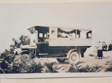
Photograph, approx. Summer 1925 - 26
... local transport phillip island...public...Phillip Island and District Historical Society Inc. phillip-island-and-the-bass-coast One of two photographs donated by Charles Grayden local transport phillip island public transport phillip island On back: Charles Grayden's first effort with public transport Summer '25 - '26. ...One of two photographs donated by Charles GraydenBlack & White photograph copy of Public Transport. People in and around the "bus".On back: Charles Grayden's first effort with public transport Summer '25 - '26.local transport phillip island, public transport phillip island -
 Eltham District Historical Society Inc
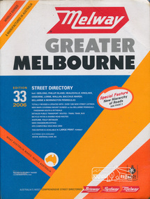
Book, Melway Publishing, Melway Greater Melbourne street directory : including Geelong, Phillip Island, Healesville, Kinglake, Gisborne, Lorne, Wallan, Bacchus Marsh Bellarine & Mornington Peninsulas; Edition 33, 2006, 2005
... public transport routes - train, tram, bus, bicycle paths & shared road routes. Eastlink fully detailed new Craigieburn bypass GPS compatible WGS/MGA Grid Special feature: New Hierachy of Roads streets,roads,melbourne,map,melway Street directory with plastic cover, coloured maps, 902 pages Melway Greater Melbourne street directory : including Geelong, Phillip Island, Healesville, Kinglake, Gisborne, Lorne, Wallan, Bacchus Marsh Bellarine & Mornington Peninsulas; Edition 33, 2006 Book Melway Publishing ...Edition 33. 2006 Coloured detailed maps accessed by a street or location index. Cover: Totally revised and updated with over 1380 new street listings new maps covering Mount Duneed on the Bellarine Peninsula, Pakenham South and Rythdale. Detailed public transport routes - train, tram, bus, bicycle paths & shared road routes. Eastlink fully detailed new Craigieburn bypass GPS compatible WGS/MGA Grid Special feature: New Hierachy of Roads Street directory with plastic cover, coloured maps, 902 pagesstreets,roads,melbourne,map,melway -
 Phillip Island and District Historical Society Inc.
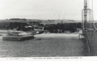
Photograph, Rose Series, Phillip Island Bridge, 1930/40
... phillip island bridge...sea transport...black & white photograph - post card - rose series...jack jenner collection...phillip island bridges...public...Phillip Island and District Historical Society Inc. phillip-island-and-the-bass-coast View of San Remo showing Suspension Bridge - completed in 1940 - demolished in 1970. From the Jack Jenner Collection. local history photographs civil engineering bridges phillip island bridge sea transport black & white photograph - post card - rose series jack jenner collection phillip island bridges public construction P3460 The Rose Series. ...View of San Remo showing Suspension Bridge - completed in 1940 - demolished in 1970. From the Jack Jenner Collection.Old Suspension Bridge right hand side of photograph. View looking towards San Remo with pier at middle left.P3460 The Rose Series. View from the Bridge looking toward San Remo - Vic.local history, photographs, civil engineering, bridges, phillip island bridge, sea transport, black & white photograph - post card - rose series, jack jenner collection, phillip island bridges, public construction -
 Phillip Island and District Historical Society Inc.
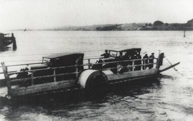
Photograph, Phillip Island Punt
... Phillip Island and District Historical Society Inc. phillip-island-and-the-bass-coast Shows the sea transport used before the Suspension Bridge was built. Punt ran between Newhaven and San Remo from 1900 - 1940. local history photographs phillip island punt black & white photograph phillip island mainland connections jack jenner collections public constructions Close-up of two cars on punt crossing between San Remo and Newhaven, Phillip Island Phillip Island Punt Photograph ...Shows the sea transport used before the Suspension Bridge was built. Punt ran between Newhaven and San Remo from 1900 - 1940.Close-up of two cars on punt crossing between San Remo and Newhaven, Phillip Islandlocal history, photographs, phillip island punt, black & white photograph, phillip island mainland connections, jack jenner collections, public constructions -
 Phillip Island and District Historical Society Inc.
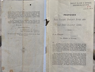
Document - leaflet, Proposed Bass Valley, Powlett River and San Remo Railway Lines
... Phillip Island and District Historical Society Inc. phillip-island-and-the-bass-coast Historical Railways San Remo Public transport Bass Valley Powlett River Submission for the Bass Valley, Powlett River and San Remo Railway line to be included in the Railways Act Submission from J. ...Submission for the Bass Valley, Powlett River and San Remo Railway line to be included in the Railways Act4 page paper booklet with small print. Pages 3-6. Page 1-2 appear to be missingnon-fictionSubmission for the Bass Valley, Powlett River and San Remo Railway line to be included in the Railways Actrailways, san remo, public transport, bass valley, powlett river -
 Phillip Island and District Historical Society Inc.
Book, ADAM-SMITH, Patsy, Romance of Australian railways, 1973
... Phillip Island and District Historical Society Inc. phillip-island-and-the-bass-coast railroads australia track history transport railways Stamped 'Cowes Public Library'. ...Stamped 'Cowes Public Library'.railroads, australia, track, history, transport, railways -
 Eltham District Historical Society Inc
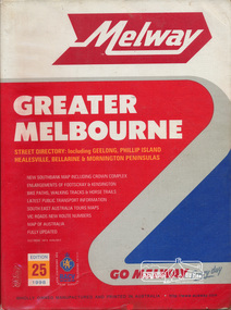
Book, Melway Great Melbourne street directory including Geelong, Phillip Island Healesville, Bellarine & Mornington Peninsulas, 1998
... Cover: (Includes) New Southbank map including Crown Complex, enlargements of Footscray and Kensington, bike paths, walking tracks & horse trails, latest public transport information, South east Australia tours maps, Vic Roads new route numbers, map of Australia streets maps roads melbourne ISSN 03113957 1 atlas (22, 772 p.) : col. maps ; Melway Great Melbourne street directory including Geelong, Phillip Island Healesville, Bellarine & Mornington Peninsulas Book ...25th edition. Coloured detailed maps accessed by a street or location index. Cover: (Includes) New Southbank map including Crown Complex, enlargements of Footscray and Kensington, bike paths, walking tracks & horse trails, latest public transport information, South east Australia tours maps, Vic Roads new route numbers, map of Australia1 atlas (22, 772 p.) : col. maps ; ISSN 03113957streets, maps, roads, melbourne -
 Eltham District Historical Society Inc
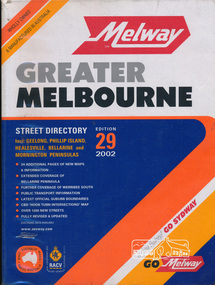
Book, Melway Publishing, Melway Greater Melbourne street directory : including Geelong, Phillip Island, Healesville, Bellarine & Mornington Peninsulas, 2002
... Cover: 20 additional pages of new maps, extended coverage of Bellarine Peninsula, further coverage of Werribee South, Public Transport Information, latest official suburb boundaries, CBD "hook turn" intersections map, over 1200 new streets, streets roads melbourne maps melway ISSN 03113957 1 atlas (24, 886 p.) : col. maps ; Melway Greater Melbourne street directory : including Geelong, Phillip Island, Healesville, Bellarine & Mornington Peninsulas. ...Edition 29. Coloured detailed maps accessed by a street or location index. Cover: 20 additional pages of new maps, extended coverage of Bellarine Peninsula, further coverage of Werribee South, Public Transport Information, latest official suburb boundaries, CBD "hook turn" intersections map, over 1200 new streets, 1 atlas (24, 886 p.) : col. maps ; ISSN 03113957streets, roads, melbourne, maps, melway -
 Eltham District Historical Society Inc
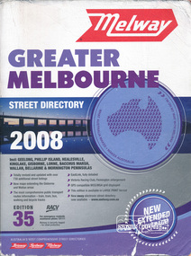
Book, Melway Greater Melbourne street directory 2008 : including Geelong, Phillip Island, Healesville, Kinglake, Gisborne, Lorne, Bacchus March, Wallan, Bellarine & Mornington Peninsulas; Edition 35, 2008, 2007
... public transport routes information - train, tram, bus, walking and bicycle tracks. Eastlink fully detailed, Victoria Racing Club, Flemington enlargement, GPS compatible WGS/MGA Grid displayed, This editon is available in LARGE PRINT format, new eway electronic street directory now available - www.melway.com.au Special feature: New Hierachy of Roads streets,roads,melbourne,map,melway Street directory, coloured maps, indexes, 1201 pages Melway Greater Melbourne street directory 2008 : including Geelong, Phillip Island, Healesville, Kinglake, Gisborne, Lorne, Bacchus March, Wallan, Bellarine & Mornington Peninsulas; Edition 35, 2008 Book Melway Publishing ...Edition 35. 2008 Coloured detailed maps accessed by a street or location index. Cover: Totally revised and updated with over 730 additional street listings, new maps extending the Gisbourne and Wallan areas. The most comprehensive public transport routes information - train, tram, bus, walking and bicycle tracks. Eastlink fully detailed, Victoria Racing Club, Flemington enlargement, GPS compatible WGS/MGA Grid displayed, This editon is available in LARGE PRINT format, new eway electronic street directory now available - www.melway.com.au Special feature: New Hierachy of Roads Street directory, coloured maps, indexes, 1201 pagesstreets,roads,melbourne,map,melway