Showing 465 items matching "quarry road"
-
 Whitehorse Historical Society Inc.
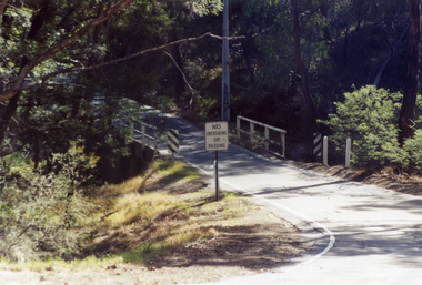
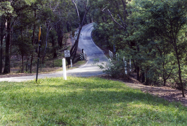
Photograph, Quarry Road Bridge, Mitcham, 2007
... Quarry Road Bridge, Mitcham...quarry road...Coloured Photo of Quarry Road Bridge, Mitcham near boundary of Whitehorse Road and Manningham Municipalities. ...Quarry Road...Whitehorse Historical Society Inc. 2-10 Deep Creek Road Mitcham melbourne quarry road mitcham bridges Coloured Photo of Quarry Road Bridge, Mitcham near boundary of Whitehorse Road and Manningham Municipalities. ...Coloured Photo of Quarry Road Bridge, Mitcham near boundary of Whitehorse Road and Manningham Municipalities. (See record number NP3411 above)quarry road, mitcham, bridges -
 Whitehorse Historical Society Inc.
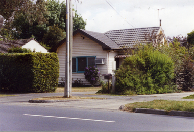
Photograph, Quarry Road, Mitcham No. 13, 2006
... Quarry Road, Mitcham No. 13...quarry road...Coloured photograph looking north of the original residence at No.13 Quarry Road Mitcham. Daughters of original owner still in residence in 2006....Whitehorse Historical Society Inc. 2-10 Deep Creek Road Mitcham melbourne quarry road mitcham no.13 Coloured photograph looking north of the original residence at No.13 Quarry Road Mitcham. ...Coloured photograph looking north of the original residence at No.13 Quarry Road Mitcham. Daughters of original owner still in residence in 2006.quarry road, mitcham, no.13 -
 Whitehorse Historical Society Inc.
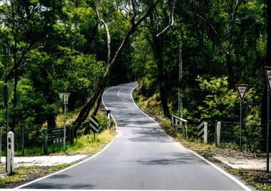
Photograph - Coloured photograph, Quarry Road Mitcham
... Quarry Road Mitcham...Quarry Road...Coloured photograph of Quarry Road, Mitcham looking south. A bridge over Mullum Mullum Creek and the Eastlink Trail appear on the lower section of the photograph - 2012...Whitehorse Historical Society Inc. 2-10 Deep Creek Road Mitcham melbourne Quarry Road Mitcham. East Link Trail Coloured photograph of Quarry Road, Mitcham looking south. ...Coloured photograph of Quarry Road, Mitcham looking south. A bridge over Mullum Mullum Creek and the Eastlink Trail appear on the lower section of the photograph - 2012quarry road, mitcham. east link trail -
 Whitehorse Historical Society Inc.
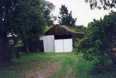
Photograph, 12 Quarry Road, Mitcham, 1998
... 12 Quarry Road, Mitcham......quarry road...This shed was on part of the orchard property of Mr Henry Ireland of 12 Quarry Road Mitcham. He has cleared the property and planted an apple orchard by about 1910. ...Her daughter married and rebuilt the house, but the outbuildings remained the same, at least until 1998. ireland henry quarry road mitcham orchardists Coloured photograph of a path leading across a lawn to an old shed with white doors. 12 Quarry Road, Mitcham Photograph Photograph ...This shed was on part of the orchard property of Mr Henry Ireland of 12 Quarry Road Mitcham. He has cleared the property and planted an apple orchard by about 1910. When he died in 1947 the orchard was cut up. Mrs Ireland lived in the house until she died. Her daughter married and rebuilt the house, but the outbuildings remained the same, at least until 1998.Coloured photograph of a path leading across a lawn to an old shed with white doors.ireland, henry, quarry road, mitcham, orchardists -
 Whitehorse Historical Society Inc.
Photograph, Quarry Road Mitcham, 2006
... Quarry Road Mitcham...quarry road...Quarry Road Mitcham Photograph Photograph ...Coloured photo of Guarry Road bridge near boundary of Whitehorse and Manningham municipalities.quarry road, mitcham, bridges -
 Sunshine and District Historical Society Incorporated
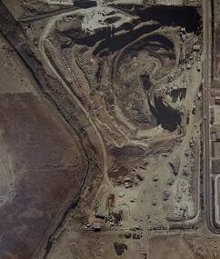
Photograph - Market Road Quarry Photograph
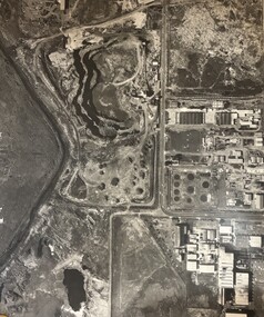
... Market Road Quarry Photograph...Road... Quarry...Large color aerial photograph showing the Market Road Quarry hole and surrounding factories...Monsanto|Pig & Calf Market|Market Timbers|Market Road Quarry|Kororoit Creek...Market Road Quarry Quarries Monsanto|Pig & Calf Market|Market Timbers|Market Road Quarry|Kororoit Creek Large color aerial photograph showing the Market Road Quarry hole and surrounding factories Photograph Market Road Quarry Photograph ...Monsanto|Pig & Calf Market|Market Timbers|Market Road Quarry|Kororoit Creekmarket road, quarry, quarries -
 Glenelg Shire Council Cultural Collection
Photograph - Photograph - Blacknose Quarry Access Road, 29/09/1952
... Photograph - Blacknose Quarry Access Road...Black and white photo of Blaknose quarry access road, looking south...Front: 'Blacknose Quarry Access Road 25-9-52 Looking South' printed bottom fram Back: purple PHT stamp...Glenelg Shire Council Cultural Collection History House Cliff Street Portland great-ocean-road Port of Portland Authority Archives Front: 'Blacknose Quarry Access Road 25-9-52 Looking South' printed bottom fram Back: purple PHT stamp Black and white photo of Blaknose quarry access road, looking south Photograph Photograph - Blacknose Quarry Access Road ...Port of Portland Authority ArchivesFront: 'Blacknose Quarry Access Road 25-9-52 Looking South' printed bottom fram Back: purple PHT stamp -
 Whitehorse Historical Society Inc.
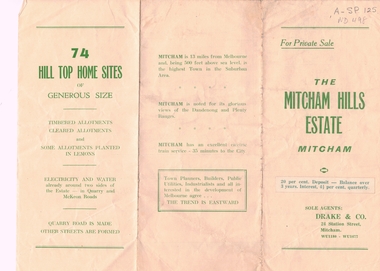
Document, Mitcham Hills Estate, n.d
... ...quarry road...Sale brochure for 'Mitcham Hills Estate', 74 sites bordered by McKeon and Quarry Roads, to the order of Commander H.E. Turner and Mrs Turner. ...Sale brochure for 'Mitcham Hills Estate', 74 sites bordered by McKeon and Quarry Roads, to the order of Commander H.E. Turner and Mrs Turner. ...Whitehorse Historical Society Inc. 2-10 Deep Creek Road Mitcham melbourne Sale brochure for 'Mitcham Hills Estate', 74 sites bordered by McKeon and Quarry Roads, to the order of Commander H.E. Turner and Mrs Turner. ...Sale brochure for 'Mitcham Hills Estate',Sale brochure for 'Mitcham Hills Estate', 74 sites bordered by McKeon and Quarry Roads, to the order of Commander H.E. Turner and Mrs Turner. Agent: Drake & Co.. With 'List of Sale Prices'.Sale brochure for 'Mitcham Hills Estate',land subdivision, mitcham hills estate, mckeon road, mitcham, quarry road, endeavour street, moresby street, beaufort street, turner, harold exton, cmdr., (mrs), drake & co. -
 Whitehorse Historical Society Inc.
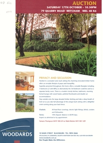
Document, Auction, 1/10/1998 12:00:00 AM
... ...quarry road...Estate agent leaflet for auction at 79 Quarry Road, Mitcham....Whitehorse Historical Society Inc. 2-10 Deep Creek Road Mitcham melbourne r. g. woodard pty ltd auctions quarry road mitcham no 79 Estate agent leaflet Estate agent leaflet for auction at 79 Quarry Road, Mitcham. ...Estate agent leafletEstate agent leaflet for auction at 79 Quarry Road, Mitcham.Estate agent leaflet r. g. woodard pty ltd, auctions, quarry road, mitcham, no 79 -
 Whitehorse Historical Society Inc.
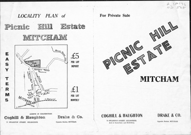
Pamphlet, Picnic Hill Estate, Mitcham, n.d
... ...quarry road...Photocopy of pamphlet, locality map and plan of 40 home sites on Picnic Hill estate extending from Quarry Road, Mitcham Road and McKeon Road, Mitcham...Whitehorse Historical Society Inc. 2-10 Deep Creek Road Mitcham melbourne land subdivision mitcham road mitcham quarry road mckeon road wooddale grove rotherwood avenue cobham road Photocopy of pamphlet, locality map and plan of 40 home sites on Picnic Hill estate extending from Quarry Road, Mitcham Road and McKeon Road, Mitcham Picnic Hill Estate, Mitcham Pamphlet Pamphlet ...Photocopy of pamphlet, locality map and plan of 40 home sites on Picnic Hill estate extending from Quarry Road, Mitcham Road and McKeon Road, Mitchamland subdivision, mitcham road, mitcham, quarry road, mckeon road, wooddale grove, rotherwood avenue, cobham road -
 Surrey Hills Historical Society Collection
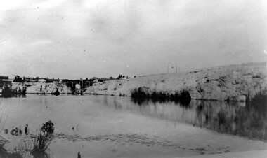
Photograph, Grovedale Road Quarry in the 1920s - looking south, c1920
... Grovedale Road Quarry in the 1920s - looking south...quarry was part of John Butler Maling's property. He was one of the original settlers of the area and farmed the area between Weybridge Street and Whitehorse Road. ...Black and white photo of the quarry between Grovedale Road and James Street taken in the 1920s and looking south. ...An object that looks like a tank on posts is in a cutting on the far bank. Grovedale Road Quarry in the 1920s - looking south Photograph Photograph ...The quarry was part of John Butler Maling's property. He was one of the original settlers of the area and farmed the area between Weybridge Street and Whitehorse Road. Clay was quarried from part of this area and used to make the bricks used in the construction of his home, known as 'Ancyra'. This is still extant at the corner of Weybridge and James Streets. Maling grazed cows and used the quarry as a water source. He was the uncle of John Butler Maling, Mayor of Camberwell. He was married to Kate Conlon in 1882. They had 3 children: Silas Young, Alick and Zillah. Maling was born in c1829 in Shepreth, Cambridgeshire; he died in Surrey Hills on 9 October 1912 and is buried in Box Hill Cemetery - CE-*-0586. Mrs Kate Maling (born c1859 in Co Meath, Ireland) died at the property on 8 March 1921. She is buried in Brighton General Cemetery. Probate was valued at over 10,000 pounds and included other properties in Sandringham, Hawthorn and Macedon. At the time of her death the Surrey Hills property was described as being 23 acres with 2 brick houses, 1 cow, 2 heifers and 40 fowls or chickens. The property was subdivided after her death. The property was subdivided into 110 house blocks in c1923 - see Maling's Estate subdivision flyer on the State Library of Victoria's website. This shows that the Grovedale Park site had been acquired by Camberwell Council by this time. An attached newspaper clipping documents prices realised for a cross-section of blocks. The MMBW map of 1925, also on the SLV website, shows the outline of the clayhole / quarry. The quarry was filled in after several drownings or near drownings and the land is now occupied by a park and playground, known as Grovedale Road Park, maintained by the City of Boroondara. Beckett Park is sited on horizon to the left beyond the trees. This documents the landscape prior to close settlement and is material to early building and farming in the Surrey Hills area.Black and white photo of the quarry between Grovedale Road and James Street taken in the 1920s and looking south. In the foreground is an area of water with reeds in the LH corner. Beyond on the high banks there are single storey houses in the background and (?) some light poles. An object that looks like a tank on posts is in a cutting on the far bank.quarries, grovedale road, james street, clay quarries, farming, kate conlon, kate maling, john butler maling, ancyra -
 Sunshine and District Historical Society Incorporated
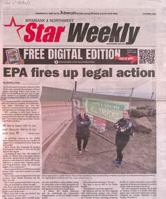
Archive - Kealba Quarry McIntyre Road Sunshine North
... Kealba Quarry McIntyre Road Sunshine North...Quarry...Kealba Landfill...Barro Group...McIntyre Road...Archive Kealba Quarry McIntyre Road Sunshine North ...The Kealba Quarry began as a basalt quarry on the edge of St Albans / Kealba / Sunshine North and was later converted into the Kealba (Sunshine) Landfill, operated by the Barro Group. Its modern history is dominated by long-running community conflict, legal battles, and the 2019 present underground landfill fires (“hotspots”) that have caused severe odour and environmental concerns. As of the 19 February 2026, EPA Victoria confirmed that 3 of the 4 hotspots have been extinguished, but one hotspot remains active.5860.01 - Kealba Quarry - EPA Fires Up Legal Action.jpg 5860.02 - Kealba Quarry - EPA Resident's Newsletter Page 1.jpg 5860.02 - Kealba Quarry - EPA Resident's Newsletter Page 2.jpg 5860.03 - Kealba Quarry - Barro Licence Cancelled.jpg 5860.04 - Kealba Quarry - Charges Dropped.jpg 5860.05 - Kealba Quarry - No Meetings Until There's New Info.jpg 5860.06 - Kealba Quarry - Landfill Not Suitable EPA.jpg 5860.07 - Kealba Quarry - Barro Group Concrete And Rock Recycling Facility Resident Survey Page 1.jpg 5860.07 - Kealba Quarry - Barro Group Concrete And Rock Recycling Facility Resident Survey Page 2.jpg 5680.08 - Kealba Quarry - EPA Failing Brimbank As Fires Still Burn.jpg 5860.09 - Kealba Quarry - EPA Failing Brimbank.jpg 5860.10 - Kealba Quarry - Barro Suspended.jpg 5860.11 - Kealba Quarry - Kealba landfill Disaster A Toxic Prison Locals Can't Escape And No End In Slight.jpgkealba quarry, kealba landfill, barro group, mcintyre road, sunshine north, kealba -
 Surrey Hills Historical Society Collection
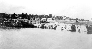
Photograph, Grovedale Road Quarry in the 1920s - looking north, c1920
... Grovedale Road Quarry in the 1920s - looking north...quarry was part of John Butler Maling's property. He was one of the original settlers of the area and farmed the area between Weybridge Street and Whitehorse Road. ...Black and white photo of the quarry between Grovedale Road and James Street taken in the 1920s and looking north. ...Shadows indicate the photo was taken in early morning or evening. Grovedale Road Quarry in the 1920s - looking north Photograph ...The quarry was part of John Butler Maling's property. He was one of the original settlers of the area and farmed the area between Weybridge Street and Whitehorse Road. Clay was quarried from part of this area and used to make the bricks used in the construction of his home, known as 'Ancyra'. This is still extant at the corner of Weybridge and James Streets. Maling grazed cows and used the quarry as a water source. He was the uncle of John Butler Maling, Mayor of Camberwell. He was married to Kate Conlon in 1882. They had 3 children: Silas Young, Alick and Zillah. Maling was born in c1829 in Shepreth, Cambridgeshire; he died in Surrey Hills on 9 October 1912 and is buried in Box Hill Cemetery - CE-*-0586. Mrs Kate Maling (born c1859 in Co Meath, Ireland) died at the property on 8 March 1921. She is buried in Brighton General Cemetery. Probate was valued at over 10,000 pounds and included other properties in Sandringham, Hawthorn and Macedon. At the time of her death the Surrey Hills property was described as being 23 cres with 2 brick houses, 1 cow, 2 heifers and 40 fowls or chickens. The property was subdivided after her death. The quarry was filled in after several drownings or near drownings and the land is now occupied by a park and playground maintained by the City of Boroondara. Beckett Park is sited on horizon to the left beyond the trees. This documents the landscape prior to close settlement and is material to early building and farming in the Surrey Hills area.Black and white photo of the quarry between Grovedale Road and James Street taken in the 1920s and looking north. In the foreground is an area of water with high banks dividing the horizontal centre. Beyond are paddocks and trees behind which is a row of at least 3 single-storey houses. Light poles can be seen along a distant street. There are many mature trees in the background. The houses and trees are positioned along Whitehorse Road in the vicinity of Westminster Street. Shadows indicate the photo was taken in early morning or evening.quarries, grovedale road, james street, surrey hills, balwyn, clay quarries, ancyra, kate conlon, kate maling, john butler maling, farming -
Glenelg Shire Council Cultural Collection
Photograph - Photograph - Blacknose Quarry, 29/09/1952
... Black and white photo of Blacknose quarry access road, looking south...Front: 'BLACKNOSE QUARRY ACCESS ROAD 25.9.52 LOOKING SOUTH ' - printed on bottom frame Back: Purple PHT stamp...Glenelg Shire Council Cultural Collection History House Cliff Street Portland great-ocean-road Port of Portland Authority Archives Port of Portland Archives Blacknose Quarry Front: 'BLACKNOSE QUARRY ACCESS ROAD 25.9.52 LOOKING SOUTH ' - printed on bottom frame Back: Purple PHT stamp Black and white photo of Blacknose quarry access road, looking south Photograph Photograph - Blacknose Quarry ...Port of Portland Authority ArchivesFront: 'BLACKNOSE QUARRY ACCESS ROAD 25.9.52 LOOKING SOUTH ' - printed on bottom frame Back: Purple PHT stampport of portland archives, blacknose quarry -
Glenelg Shire Council Cultural Collection
Photograph - Photograph - Cape Grant Quarry, 27/08/1953
... Black and white photo of section of Cape Grant quarry road...Glenelg Shire Council Cultural Collection History House Cliff Street Portland great-ocean-road Port of Portland Authority Archives Port of Portland Archives Cape Grant Quarry Back: Purple PHT stamp Black and white photo of section of Cape Grant quarry road Photograph Photograph - Cape Grant Quarry ...Port of Portland Authority ArchivesBack: Purple PHT stampport of portland archives, cape grant quarry -
Glenelg Shire Council Cultural Collection
Photograph - Photograph - Cape Grant Quarry, 27/08/1953
... Black and white photo of a section of Cape Grant quarry road...Glenelg Shire Council Cultural Collection History House Cliff Street Portland great-ocean-road Port of Portland Authority Archives Port of Portland Archives Cape Grant Quarry Back: Purple PHT stamp Black and white photo of a section of Cape Grant quarry road Photograph Photograph - Cape Grant Quarry ...Port of Portland Authority ArchivesBack: Purple PHT stampport of portland archives, cape grant quarry -
Glenelg Shire Council Cultural Collection
Photograph - Photograph - Cape Grant Quarry, 27/08/1953
... Black and white photo of Cape Grant quarry road culvert...Glenelg Shire Council Cultural Collection History House Cliff Street Portland great-ocean-road Port of Portland Authority Archives Port of Portland Archives Cape Grant Quarry Back: Purple PHT stamp Black and white photo of Cape Grant quarry road culvert Photograph Photograph - Cape Grant Quarry ...Port of Portland Authority ArchivesBack: Purple PHT stampport of portland archives, cape grant quarry -
Glenelg Shire Council Cultural Collection
Photograph - Photograph - Cape Grant Quarry, 08/07/1953
... Close up of section of Cape Grant quarry road...Close up of section of Cape Grant quarry road Photograph Photograph - Cape Grant Quarry ...Port of Portland Authority ArchivesBack: Purple PHT stampport of portland archives, cape grant quarry -
Glenelg Shire Council Cultural Collection
Photograph - Photograph - Cape Grant Quarry, 27/08/1953
... Black and white photo of Cape Grant quarry road culvert, looking south-west....Glenelg Shire Council Cultural Collection History House Cliff Street Portland great-ocean-road Port of Portland Authority Archives Back: Purple PHT stamp Black and white photo of Cape Grant quarry road culvert, looking south-west. Photograph Photograph - Cape Grant Quarry ...Port of Portland Authority ArchivesBack: Purple PHT stamp -
Glenelg Shire Council Cultural Collection
Photograph - Photograph - Cape Grant Quarry, 03/07/1953
... Black and white photo of culvert on Cape Grant quarry road. Lawrence Rocks in background...Glenelg Shire Council Cultural Collection History House Cliff Street Portland great-ocean-road Port of Portland Authority Archives Port of Portland Archives Cape Grant Quarry Back: Purple PHT stamp Black and white photo of culvert on Cape Grant quarry road. ...Port of Portland Authority ArchivesBack: Purple PHT stampport of portland archives, cape grant quarry -
Glenelg Shire Council Cultural Collection
Photograph - Photograph - Cape Grant Quarry, Portland, n.d
... Black and white photo, Cape Grant Quarry road culvert, looking north east....Glenelg Shire Council Cultural Collection History House Cliff Street Portland great-ocean-road Port of Portland Authority Archives Port of Portland Archives Cape Grant Quarry Portland Harbour construction Front: Back- Purple PHT stamp Black and white photo, Cape Grant Quarry road culvert, looking north east. ...Port of Portland Authority ArchivesFront: Back- Purple PHT stampport of portland archives, cape grant quarry, portland harbour, construction -
Whitehorse Historical Society Inc.
Article, Horse-And-Cart Man, 1950's
... An article about George Taylor of Quarry Road, Mitcham who mainly delivered firewood by horse and cart....An article about George Taylor of Quarry Road, Mitcham who mainly delivered firewood by horse and cart. ...An article about George Taylor of Quarry Road, Mitcham who mainly delivered firewood by horse and cart.An article about George Taylor of Quarry Road, Mitcham who mainly delivered firewood by horse and cart.An article about George Taylor of Quarry Road, Mitcham who mainly delivered firewood by horse and cart.taylor, george -
Glenelg Shire Council Cultural Collection
Photograph - Photograph - Cape Grant Quarry, n.d
... Black and white photo aerial photo, looking towards Cape Grant quarry, showing quarry road and crusher...'Reduce to 28 ems wide' in pencil, top border. '(15); pencil, bottom border. '58 %' - green pencil, centre Black and white photo aerial photo, looking towards Cape Grant quarry, showing quarry road and crusher Photograph Photograph - Cape Grant Quarry ...Port of Portland Authority ArchivesBack: 1 cm border ruled around photo in pencil. 'Reduce to 28 ems wide' in pencil, top border. '(15); pencil, bottom border. '58 %' - green pencil, centreport of portland archives, cape grant quarry -
 Sunshine and District Historical Society Incorporated
Photograph - Brooklyn Quarries Photograph
... Road... Quarry...Monsanto Pig & Calf Market Market Timbers Market Road Quarry Kororoit Creek Connor Shea...Large black and white aerial photograph of various quarry holes off Market and Somerville Roads including the surrounding factories...Monsanto Pig & Calf Market Market Timbers Market Road Quarry Kororoit Creek Connor Shea Monsant Pig & Calf Marke Market Timber Market Road Quarry Kororoit Cree Corror Shea Large black and white aerial photograph of various quarry holes off Market and Somerville Roads including the surrounding factories Photograph Brooklyn Quarries Photograph ...This photograph shows the following sites. Monsanto Pig & Calf Market Market Timbers Market Road Quarry Kororoit Creek Connor Sheamonsant, pig & calf marke, market timber, market road, quarry, kororoit cree, corror shea -
Glenelg Shire Council Cultural Collection
Photograph - Photograph - Cape Grant Quarry, n.d
... Black and white photo of Cape Grant Quarry road, crane on clifftop section; Earth moving equipment on clift face....Glenelg Shire Council Cultural Collection History House Cliff Street Portland great-ocean-road Port of Portland Authority Archives Port of Portland Archives Cape Grant Quarry Black and white photo of Cape Grant Quarry road, crane on clifftop section; Earth moving equipment on clift face. ...Port of Portland Authority Archivesport of portland archives, cape grant quarry -
 Whitehorse Historical Society Inc.
Document - Notes from Trove, Sampson Murder, Jan 1928, 1928
... Notes from the State Library's Trove collection on the murder of Iolene Sampson 28 years old on 3 Jan 1928 at quarry Road Mitcham and the subsequent court case on 22 Feb 1928....Iolene Sampson had been married to Ted Sampson for 15 months and they were orchardists near the corner of Quarry and Mitcham Roads. The Kleinert's had an orchard across the lane from them. ...Whitehorse Historical Society Inc. 2-10 Deep Creek Road Mitcham melbourne Notes from the State Library's Trove collection on the murder of Iolene Sampson 28 years old on 3 Jan 1928 at quarry Road Mitcham and the subsequent court case on 22 Feb 1928. ...Notes from the State Library's Trove collection on the murder of Iolene Sampson 28 years old on 3 Jan 1928 at quarry Road Mitcham and the subsequent court case on 22 Feb 1928.Iolene Sampson had been married to Ted Sampson for 15 months and they were orchardists near the corner of Quarry and Mitcham Roads. The Kleinert's had an orchard across the lane from them. Ernest Ambrose Kleinert, 20 years old, was tried for the murder of Iolene Simpson but was acquitted. The murder was never solved.kleinert ernest ambrose, , sampson mary iolene, sampson edward augustus -
Glenelg Shire Council Cultural Collection
Photograph - Photograph - Cape Grant Quarry, 27/08/1953
... Black and white photo of section of Cape Grant quarry road. Two men on left watching man operate bulldozer in middle of road...Glenelg Shire Council Cultural Collection History House Cliff Street Portland great-ocean-road Port of Portland Authority Archives Port of Portland Archives Cape Grant Quarry Back: Purple PHT stamp Black and white photo of section of Cape Grant quarry road. ...Port of Portland Authority ArchivesBack: Purple PHT stampport of portland archives, cape grant quarry -
 Rutherglen Historical Society
Image, W. H. Pleming, 13/10/1992
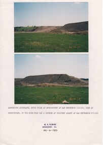
... ...chiltern quarry...road...Rutherglen Historical Society Murray Street Rutherglen high-country hume freeway chiltern quarry road works Date on images: "92-10-13" Caption below photos: "Asphelting aggregate stock piled at Springhurst at map reference 512-927, used at Springhurst on the Hume Free Way & crushed at Chiltern Quarry at map reference 671-969." ...Two colour photographs printed on A4 paper with typed caption and a donor stamp. Date of photos in bottom right hand of each image.Date on images: "92-10-13" Caption below photos: "Asphelting aggregate stock piled at Springhurst at map reference 512-927, used at Springhurst on the Hume Free Way & crushed at Chiltern Quarry at map reference 671-969."hume freeway, chiltern quarry, road works -
Whitehorse Historical Society Inc.
Document, Charlesworth Estate, n.d
... ...Quarry Road...Charlesworth Estate Mitcham Ireland Family Quarry Road Mitcham Mitcham Scout Hall Ireland Avenue Mitcham Mitcham Reminiscences of Mrs Ireland. ...Reminiscences of Mrs Ireland.Reminiscences of Mrs Ireland, resident of Mitcham from 1914.Reminiscences of Mrs Ireland. charlesworth estate, mitcham, ireland family, quarry road, mitcham, mitcham scout hall, ireland avenue, mitcham, mitcham -
Whitehorse Historical Society Inc.
Document, Descendents of Albert Edward Henry Charlesworth, 1/10/2002 12:00:00 AM
... ...Quarry Road...Whitehorse Historical Society Inc. 2-10 Deep Creek Road Mitcham melbourne Charlesworth Albert Edward Henry Charlesworth Albert Roy Family trees Charlesworth family McIntyre family Collins family Wallace family Charlesworth Estate Mitcham Doncaster East Road Mitcham Harrison Street Mitcham Barrett Street Mitcham Quarry Road Mitcham Family tree of Albert Henry Charlesworth, includes plan of Charlesworth Estate, Mitcham Family tree of Albert Henry Charlesworth, includes plan of Charlesworth Estate, Mitcham Descendents of Albert Edward Henry Charlesworth Document Document ...Family tree of Albert Henry Charlesworth, includes plan of Charlesworth Estate, MitchamFamily tree of Albert Henry Charlesworth, includes plan of Charlesworth Estate, MitchamFamily tree of Albert Henry Charlesworth, includes plan of Charlesworth Estate, Mitchamcharlesworth, albert edward henry, charlesworth, albert roy, family trees, charlesworth family, mcintyre family, collins family, wallace family, charlesworth estate, mitcham, doncaster east road, mitcham, harrison street, mitcham, barrett street, mitcham, quarry road, mitcham