Showing 277 items matching "quartz reefs"
-
 Stawell Historical Society Inc
Map, Department of Mines Victoria, The Reefs. The Principle Reefs at Quartz Reefs, 1868
... The Principle Reefs at Quartz Reefs...c1868 Map showing the position of principal Reefs at Quartz Reefs...Tracing Shewing the position of the principle reefs at Quartz Reefs. Scale 8 Chains to an inch ...Stawell Historical Society Inc 46 Longfield St Stawell grampians mining gold map Tracing Shewing the position of the principle reefs at Quartz Reefs. Scale 8 Chains to an inch c1868 Map showing the position of principal Reefs at Quartz Reefs The Reefs. ...c1868 Map showing the position of principal Reefs at Quartz ReefsTracing Shewing the position of the principle reefs at Quartz Reefs. Scale 8 Chains to an inch mining, gold, map -
 Bendigo Historical Society Inc.
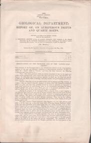
Document - MINING REPORTS - REPORT OF, ON AURIFEROUS DRIFTS AND QUARTZ REEFS
... MINING REPORTS - REPORT OF, ON AURIFEROUS DRIFTS AND QUARTZ REEFS... on Auriferous Drifts and Quartz Reefs...Printed document: Geological Department: Report of, on auriferous Drifts and Quartz Reefs, dated 8th May,1866. Paper describes the gravels and rocks of a Geological Survey. ...Document MINING REPORTS - REPORT OF, ON AURIFEROUS DRIFTS AND QUARTZ REEFS ...Printed document: Geological Department: Report of, on auriferous Drifts and Quartz Reefs, dated 8th May,1866. Paper describes the gravels and rocks of a Geological Survey. Survey is compared with the lower drifts of Bendigo, Epsom, Ballaarat, Castlemaine and other gold-fields. Four colour sketch-sections included. Document is part of the Albert Richardson Collection. gold, mining reports, mining reports, report of, on auriferous drifts and quartz reefs, mr bindon, alfred r c selwyn, john ferres -
 Bendigo Historical Society Inc.
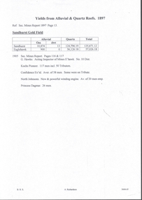
Document - MINING REPORTS - YIELDS FROM ALLUVIAL & QUARTZ REEFS 1897
... MINING REPORTS - YIELDS FROM ALLUVIAL & QUARTZ REEFS 1897... Yields from Alluvial & Quartz Reefs 1897...Document MINING REPORTS - YIELDS FROM ALLUVIAL & QUARTZ REEFS 1897 ...Handwritten notes give details of alluvial, and quartz yields from the Sandhurst and Eaglehawk gold fields. Ref. Sec. Mines Report 1897, Page 13. Also, a report from the Sec. Mines Report1905 Pages 116 & 117 mentioning the number of men employed at Kochs Pioneer, Confidence Ex'td, North Johnsons and Princess Dagmar Mines. Report by G Hawke, Acting Inspector of Mines E'Hawk No 10 Dist.document, gold, mining reports, yields from alluvial & quartz reefs 1897, sandhurst gold field, g hawke, kochs pioneer, confidence ex'td, north johnsons, princess dagmar -
Bendigo Historical Society Inc.
Map - PLAN SHOWING SURFACE EXTENSIONS OF QUARTZ REEFS northward from Eaglehawk, Sandhurst
... PLAN SHOWING SURFACE EXTENSIONS OF QUARTZ REEFS northward from Eaglehawk, Sandhurst...Plan shewing surface extensions of quartz reefs northward from Eaglehawk, Sandhurst, 8 chains to an inch....Map PLAN SHOWING SURFACE EXTENSIONS OF QUARTZ REEFS northward from Eaglehawk, Sandhurst ...Notes to accompany...." By Reginald A.F. Murray. Mining Dept. Melbourne, Dec. 1879, not with plan. Available Plan shewing surface extensions of quartz reefs northward from Eaglehawk, Sandhurst, 8 chains to an inch. -
 Stawell Historical Society Inc
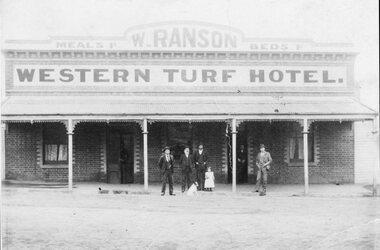
Photograph, Western Turf Hotel Quartz Reefs in Upper Main Street Stawell with Mr W Ranson as licensee
... Western Turf Hotel Quartz Reefs in Upper Main Street Stawell with Mr W Ranson as licensee...Four men a child and a dog standing in front of Western Turf Hotel Quartz Reefs Upper Main Street. Mr W Ranson was licensee from 1899 until 1903...Stawell Historical Society Inc 46 Longfield St Stawell grampians Four men a child and a dog standing in front of Western Turf Hotel Quartz Reefs Upper Main Street. Mr W Ranson was licensee from 1899 until 1903 Stawell Western Turf Hotel Quartz Reefs in Upper Main Street Stawell with Mr W Ranson as licensee Photograph ...Four men a child and a dog standing in front of Western Turf Hotel Quartz Reefs Upper Main Street. Mr W Ranson was licensee from 1899 until 1903stawell -
 Bendigo Historical Society Inc.
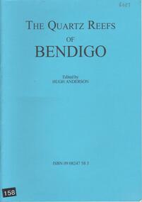
Book - THE QUARTZ REEFS OF BENDIGO, 2010
... THE QUARTZ REEFS OF BENDIGO...A 22 page soft cover booklet 'The Quartz Reefs of Bendigo' Edited by Hugh Anderson. ...Illustrations taken from Joseph Panton's report of 1849. Book THE QUARTZ REEFS OF BENDIGO ...A 22 page soft cover booklet 'The Quartz Reefs of Bendigo' Edited by Hugh Anderson. Contents include Victoria Reef, Diamond Hill, Glasgow Reef, Specimen Hill, Johnson's Reef and New Chum Reef. Illustrations taken from Joseph Panton's report of 1849.Hugh Anderson -
 Stawell Historical Society Inc
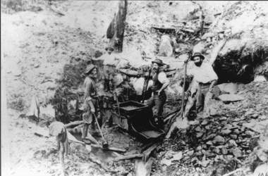
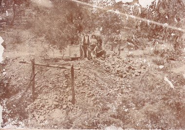
Photograph, Mining Scene at Quartz Reefs, St Georges Lead. Three miners with a gold rocking cradle
... Mining Scene at Quartz Reefs, St Georges Lead. Three miners with a gold rocking cradle....Mining Scene at Quartz Reefs, St Georges Lead. Three miners with a gold rocking cradle. ...Miners around Big Hill area at work St Georges Lead c 1860's. Note gold rocking cradle. This photo was amongst several mining photos, all of which were identified and catalogued under their correct mine name in 2010-2011.Three men with shovels around a gold mine cradle on a rocky hill side.stawell -
 Bendigo Historical Society Inc.
Document - MINING REPORTS - GEOLOGICAL REPORT OF MAIN SECTION OF GOLDFIELD
... Formation of Bendigo Quartz Reefs by F R Stilwell Page 1028 to 1032...Also mentioned are different zones of sediments, anticlines, structure of the field and references: Page 1028 Formation of Bendigo Quartz Reefs by F R Stilwell to 1032 and pages 160 to 163 'Ore deposits as Related to Structural Features - A H Newhouse. ...Also mentioned are different zones of sediments, anticlines, structure of the field and references: Page 1028 Formation of Bendigo Quartz Reefs by F R Stilwell to 1032 and pages 160 to 163 'Ore deposits as Related to Structural Features - A H Newhouse. ...Handwritten notes by Albert Richardson, with typed copy, on a Geological report of main section in a length of 5 miles. Report mentions sandstones and slates, with occasional calcareous bands, which show a cyclic arrangement. Also mentioned are different zones of sediments, anticlines, structure of the field and references: Page 1028 Formation of Bendigo Quartz Reefs by F R Stilwell to 1032 and pages 160 to 163 'Ore deposits as Related to Structural Features - A H Newhouse. document, gold, mining reports, mining reports, geological report of main section of goldfield, the bendigo goldfields page 1015, formation of bendigo quartz reefs by f r stilwell page 1028 to 1032, ore deposits as related to structural features pages 160 to 163 a h newhouse -
Clunes Museum
Newspaper - NEWSPAPER CUTTING, ARGUS AGE, 1 CLUNES BIRTHDAY .2 FAMOUS MINING TOWNS, 4 - 7 - 1931 27 - 8 - 32
... FAMOUS MINING TOWNS .1. 80TH ANNIVERSARY JULY 4, 1931 .2. THE QUARTZ REEFS OF CLUNES. SOME INTERESTING DOCUMENTS.....CLUNES MINING 80TH ANNIVERSARY JULY 4, 1931 .2. THE QUARTZ REEFS OF CLUNES. SOME INTERESTING DOCUMENTS....FAMOUS MINING TOWNS .1. 80TH ANNIVERSARY JULY 4, 1931 .2. THE QUARTZ REEFS OF CLUNES. SOME INTERESTING DOCUMENTS.. ...NEWSPAPER HEADLINES. CLUNES BIRTHDAY. FAMOUS MINING TOWNS .1. 80TH ANNIVERSARY JULY 4, 1931 .2. THE QUARTZ REEFS OF CLUNES. SOME INTERESTING DOCUMENTS..2 NEWSPAPER CUTTINGS. .1. CLUNES MINING 80TH ANNIVERSARY JULY 4, 1931 .2. THE QUARTZ REEFS OF CLUNES. SOME INTERESTING DOCUMENTS.local history, document, newspaper cutting, mining -
 Federation University Historical Collection
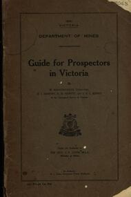
Book, Guide for Prospectors in Victoria, 1931, 1931
... ...quartz reefs...Chapter heading s include: working alluvial deposits, equipment, geology of Victoria, gold deposits, quartz reefs, indicators, economic minerals, assistance to prospectors, Miners' Right, mining bye-law, mining leases, forest regulations and glossary. ...Chapter heading s include: working alluvial deposits, equipment, geology of Victoria, gold deposits, quartz reefs, indicators, economic minerals, assistance to prospectors, Miners' Right, mining bye-law, mining leases, forest regulations and glossary. ...The handbook was intended for those with little experience who wanted to prospect of fossick.Grey soft covered book of 90 pages. Includes fold out map of a portion of Victoria showing auriferous areas and mineral localities. Also show Counties of Victoria and localities of minerals such as tin, antimony, copper, silver lead, Malybdenite, tungsten ores, manganese, platinum, osmiridium and iron. Chapter heading s include: working alluvial deposits, equipment, geology of Victoria, gold deposits, quartz reefs, indicators, economic minerals, assistance to prospectors, Miners' Right, mining bye-law, mining leases, forest regulations and glossary. Descriptions are given of a god dish, puddling tub, cradle, puddling machine, ground sluicing, boring, windlass, whim, hand dollying, sweeping, California pump, and wing dam.mining, baragwanath, gold, prospector, geology, quartz reefs, alluvial deposits, indicators, victorian goldfields, miners rights, mining leases, forest regulations, sluicing, sluice box, puddling machine, miner's cradle, whim, whip, california pump, gold nuggets, saddle reef, ballarat indicators, state batteries -
 Stawell Historical Society Inc
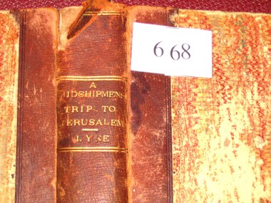
Book, Augustus A. Lyne R.N, A Midshipman’s Trip to Jerusalem, 1871
... This book at one time belonged to the Pleasant Creek Library and Mechanic Insititute, Quartz Reefs. The Adventures of a cavalcade of British Naval Officers in the Holy Land. ...Pleasant Creek Library and Mechanics Institute Quartz Reef. Members will be held responsible for any damage done to books in their possession....Pleasant Creek Library and Mechanics Institute Quartz Reef. Members will be held responsible for any damage done to books in their possession. ...This book at one time belonged to the Pleasant Creek Library and Mechanic Insititute, Quartz Reefs. The Adventures of a cavalcade of British Naval Officers in the Holy Land. Dedicated by permission to: Captain George Lethbridge R.N. and the Officers of H.M.S. TrafalgarBrown Spine and Cornors, front and back patterned paper cover, part missing, clear tape on spine top and bottom. Top Right Inside Cover J.W. Evans & Co. Binders 11A Flinders Way. Notice pasted on inside of front Cover. No. 1313. Pleasant Creek Library and Mechanics Institute Quartz Reef. Members will be held responsible for any damage done to books in their possession.stawell education -
 The Beechworth Burke Museum
Photograph
... ...quartz reefs beechworth...In the late nineteenth and early twentieth centuries, small syndicates of miners continued to work old or abandoned quartz reefs, often persisting without the assistance of heavy machinery to remove the large amounts of rock, in order to obtain yields at ever greater depths. ...In the late nineteenth and early twentieth centuries, small syndicates of miners continued to work old or abandoned quartz reefs, often persisting without the assistance of heavy machinery to remove the large amounts of rock, in order to obtain yields at ever greater depths. ...This image is a reproduction of an 1899 original depicting the 'Williams Good Luck Mine' on the Mopoke Reef (also called 'Morepork Gully') in the Dingle Ranges, approximately three miles from Beechworth. A large opening to a mine can be seen behind the men in the photograph, with a wheeled cart on a track leading to the men's position, where the soil and rocks have been hauled away. This photograph interestingly contains dogs alongside the miners. While dogs have been recorded as deterrents to thieves in the Victorian goldfields, these dogs appear as companions to these men. Following the discovery of gold at Beechworth in 1852, rushes quickly followed at surrounding creeks and gullies in the district. In the late nineteenth and early twentieth centuries, small syndicates of miners continued to work old or abandoned quartz reefs, often persisting without the assistance of heavy machinery to remove the large amounts of rock, in order to obtain yields at ever greater depths. The group of miners in this photograph are Mr. Roger Williams and Sons, who revived operations at the ‘Old Good Luck’ mine on the Mopoke Reef in the Dingle Range near Beechworth around 1892, working the site for more than two decades. An emigrant from Cornwall with experience in the tin mining industry, 19 year old Roger Williams senior sailed to New Zealand in 1840, then to Australia where he spent time in the Bendigo Gold Fields before settling in Beechworth in the early 1860s. Mr Williams senior worked on various mining activities in the district, including the Rocky Mountain Tunnel project. Conversant with the character of gold-bearing reefs in the area, the syndicate dug an eight hundred foot tunnel, digging down as far down as two hundred feet with little capital save their labour, to connect and provide better working access to the mass of reefs and veins in the vicinity. Progress was hampered by poor air quality charged with fumes from dynamite and large quantities of rock had to be crushed to obtain payable yields. The Victorian Goldfields are filled with ruins and remnants of the area's rich mining history, ranging from small alluvial diggings to the remains of huge mining companies. Site names often changed several times throughout the nineteenth and twentieth centuries. Some sites were abandoned and forgotten, others were worked continuously over many decades. The names of mines were often repeated at different locations throughout the Victorian Goldfields. For example, there is a Mopoke Gully heritage mine near Fryers Creek, Victoria. 'Mopoke' is a common onomatopoeic name for Morepork and Australian Boobook owls.This image has historical, social and research significance for patterns of emigration during of the Victorian Gold Rush, and the historical, social and environmental impacts of mining at Beechworth at the turn of the nineteenth and twentieth centuries. As gold became scarce and government support and large company investment waned, poor hard-working miners laboured intensively to make a living through periods of high unemployment. This image can be compared and studied alongside other historical mining photographs and objects in the Burke Museum Collection. It has potential to improve our understanding of miners working conditions and the shifting character of mining in the Beechworth district.Sepia coloured rectangular photograph printed on gloss photographic paper mounted on card. Obverse: Williams/ Good/ Luck Reverse: A02498/ 1997. 2498/ Good Luck/ Mine/ 1899/ Mopoke. burke museum, beechworth museum, beechworth, gold fields, gold rush, victorian gold rush, gold ming history, colonial australia, australian gold rushes, mining technology, beechworth historic district, indigo gold trail, migration, indigo shire, good luck gold mine, victorian goldfields, mining syndicates, gold fever, quartz-mining, small-scale mining, old good luck mine, mopoke gully, quartz reefs beechworth -
 The Beechworth Burke Museum
Photograph
... ...quartz reefs beechworth...In the late nineteenth and early twentieth centuries, small syndicates of miners continued to work old or abandoned quartz reefs, often persisting without the assistance of heavy machinery to remove the large amounts of rock, in order to obtain yields at ever greater depths. ...In the late nineteenth and early twentieth centuries, small syndicates of miners continued to work old or abandoned quartz reefs, often persisting without the assistance of heavy machinery to remove the large amounts of rock, in order to obtain yields at ever greater depths. ...This image is a reproduction of an 1899 original depicting the 'Williams Good Luck Mine' on the Mopoke Reef (also called 'Morepork Gully') in the Dingle Ranges, approximately three miles from Beechworth. The foreground of the image is littered with piles of smashed rock and detritus, known as ‘mullock’, beside a reinforced mine shaft, a vertical access passageway allowing miners to enter the mine and haul ore out using lifting technology such as a poppet heads, whims or windlasses. A group of miners and a dog appear close to an open-sided miner’s hut. Following the discovery of gold at Beechworth in 1852, rushes quickly followed at surrounding creeks and gullies in the district. In the late nineteenth and early twentieth centuries, small syndicates of miners continued to work old or abandoned quartz reefs, often persisting without the assistance of heavy machinery to remove the large amounts of rock, in order to obtain yields at ever greater depths. The group of miners in this photograph are Mr. Roger Williams and Sons, who revived operations at the ‘Old Good Luck’ mine on the Mopoke Reef in the Dingle Range near Beechworth around 1892, working the site for more than two decades. An emigrant from Cornwall with experience in the tin mining industry, 19 year old Roger Williams senior sailed to New Zealand in 1840, then to Australia where he spent time in the Bendigo Gold Fields before settling in Beechworth in the early 1860s. Mr Williams senior worked on various mining activities in the district, including the Rocky Mountain Tunnel project. Conversant with the character of gold-bearing reefs in the area, the syndicate dug an eight hundred foot tunnel, digging down as far down as two hundred feet with little capital save their labour, to connect and provide better working access to the mass of reefs and veins in the vicinity. Progress was hampered by poor air quality charged with fumes from dynamite and large quantities of rock had to be crushed to obtain payable yields. The Victorian Goldfields are filled with ruins and remnants of the area's rich mining history, ranging from small alluvial diggings to the remains of huge mining companies. Site names often changed several times throughout the nineteenth and twentieth centuries. Some sites were abandoned and forgotten, others were worked continuously over many decades. The names of mines were often repeated at different locations throughout the Victorian Goldfields. For example, there is a Mopoke Gully heritage mine near Fryers Creek, Victoria. 'Mopoke' is a common onomatopoeic name for Morepork and Australian Boobook owls.This image has historical, social and research significance for patterns of emigration during of the Victorian Gold Rush, and the historical, social and environmental impacts of mining at Beechworth at the turn of the nineteenth and twentieth centuries. As gold became scarce and government support and large company investment waned, poor hard-working miners laboured intensively to make a living through periods of high unemployment. This image can be compared and studied alongside other historical mining photographs and objects in the Burke Museum Collection. It has potential to improve our understanding of miners working conditions and the shifting character of mining in the Beechworth district.Sepia coloured rectangular photograph printed on gloss photographic paper mounted on card.Obverse: Reverse: A02497/ 1997.2497/ 'Good/ Luck/ Mine'/ Morepork/ Gully/ Mrs Joyce/ Bright/ Tunnel/ 800 ft/ 1899. burke museum, beechworth museum, beechworth, gold fields, gold rush, victorian gold rush, gold ming history, colonial australia, australian gold rushes, mining technology, beechworth historic district, indigo gold trail, migration, indigo shire, good luck gold mine, victorian goldfields, mining syndicates, gold fever, quartz-mining, small-scale mining, old good luck mine, mopoke gully, quartz reefs beechworth -
 The Beechworth Burke Museum
Photograph - Photograph - Reproduction, Unknown
... ...quartz reefs beechworth...In the late nineteenth and early twentieth centuries, small syndicates of miners continued to work old or abandoned quartz reefs, often persisting without the assistance of heavy machinery to remove the large amounts of rock, in order to obtain yields at ever greater depths. ...In the late nineteenth and early twentieth centuries, small syndicates of miners continued to work old or abandoned quartz reefs, often persisting without the assistance of heavy machinery to remove the large amounts of rock, in order to obtain yields at ever greater depths. ...This image is a reproduction of an 1899 original depicting the 'Williams Good Luck Mine' on the Mopoke Reef (also called 'Morepork Gully') in the Dingle Ranges, approximately three miles from Beechworth. The foreground of the image is littered with piles of smashed rock and detritus, known as ‘mullock’, beside a reinforced mine shaft, a vertical access passageway allowing miners to enter the mine and haul ore out using lifting technology such as a poppet heads, whims or windlasses. A group of miners and a dog appear close to an open-sided miner’s hut. Following the discovery of gold at Beechworth in 1852, rushes quickly followed at surrounding creeks and gullies in the district. In the late nineteenth and early twentieth centuries, small syndicates of miners continued to work old or abandoned quartz reefs, often persisting without the assistance of heavy machinery to remove the large amounts of rock, in order to obtain yields at ever greater depths. The group of miners in this photograph are Mr. Roger Williams and Sons, who revived operations at the ‘Old Good Luck’ mine on the Mopoke Reef in the Dingle Range near Beechworth around 1892, working the site for more than two decades. An emigrant from Cornwall with experience in the tin mining industry, 19 year old Roger Williams senior sailed to New Zealand in 1840, then to Australia where he spent time in the Bendigo Gold Fields before settling in Beechworth in the early 1860s. Mr Williams senior worked on various mining activities in the district, including the Rocky Mountain Tunnel project. Conversant with the character of gold-bearing reefs in the area, the syndicate dug an eight hundred foot tunnel, digging down as far down as two hundred feet with little capital save their labour, to connect and provide better working access to the mass of reefs and veins in the vicinity. Progress was hampered by poor air quality charged with fumes from dynamite and large quantities of rock had to be crushed to obtain payable yields. The Victorian Goldfields are filled with ruins and remnants of the area's rich mining history, ranging from small alluvial diggings to the remains of huge mining companies. Site names often changed several times throughout the nineteenth and twentieth centuries. Some sites were abandoned and forgotten, others were worked continuously over many decades. The names of mines were often repeated at different locations throughout the Victorian Goldfields. For example, there is a Mopoke Gully heritage mine near Fryers Creek, Victoria. 'Mopoke' is a common onomatopoeic name for Morepork and Australian Boobook owls. This image has historical, social and research significance for patterns of emigration during of the Victorian Gold Rush, and the historical, social and environmental impacts of mining at Beechworth at the turn of the nineteenth and twentieth centuries. As gold became scarce and government support and large company investment waned, poor hard-working miners laboured intensively to make a living through periods of high unemployment. This image can be compared and studied alongside other historical mining photographs and objects in the Burke Museum Collection. It has potential to improve our understanding of miners working conditions and the shifting character of mining in the Beechworth district. Black and white rectangular reproduction photograph printed on matte photographic paper.Obverse: Williams Good Luck Mine Beechworth / Roger! / Reverse: 6858 / burke museum, beechworth museum, beechworth, gold fields, gold rush, victorian gold rush, gold ming history, colonial australia, australian gold rushes, mining technology, beechworth historic district, indigo gold trail, migration, indigo shire, good luck gold mine, victorian goldfields, mining syndicates, gold fever, quartz-mining, small-scale mining, old good luck mine, mopoke gully, quartz reefs beechworth -
 Stawell Historical Society Inc
Photograph, Magdala-Cum-Moonlight Gold Mine underground at 800 feet Underground 1902
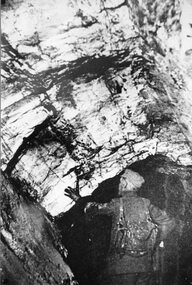
... Underground miner inspecting overhead Quartz reef. ...Stawell Historical Society Inc 46 Longfield St Stawell grampians Mining Scene Flat Reef at 800ft level Underground in Magdala-Cum-Moonlight Gold Mine 1895 Stawell Mining Underground miner inspecting overhead Quartz reef. Magdala-Cum-Moonlight Gold Mine underground at 800 feet Underground 1902 Photograph ...Mining Scene Flat Reef at 800ft level Underground in Magdala-Cum-Moonlight Gold Mine 1895Underground miner inspecting overhead Quartz reef. stawell mining -
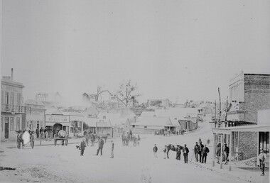 Stawell Historical Society Inc
Photograph, Upper Main Street looking East from Patrick Street corner across Layzell Street 1866
... Oriental Bank second on left then Quartz Reef Timber Yards. Intersection is Layzell St Main Street. ...Upper Main street with Poppet Heads in the background, the Oriental Bank second on left & then Quartz Reef Timber Yard 1867. Lots of people and wagons in street. ...Oriental Bank second on left then Quartz Reef Timber Yards. Intersection is Layzell St Main Street. ...Upper Main Street looking East. Poppet Heads in Background. Oriental Bank second on left then Quartz Reef Timber Yards. Intersection is Layzell St Main Street. Advertiser Office on right in front of Earlier Mechanics Institute. Part of a collection of Photographs by Mr. O.G. Armstrong as commissioned by the Shire of Stawell for the Inter-colonial and Paris Exhibition in Melbourne in 1866. View of the top end of Main Street 1866 with the Commercial Hotel in the left foreground. On the right is the Advertiser Newspaper office an Ararat newspaper before one was started in Stawell. The building on the right with the ladder in front was the Mechanics Institute later burned down twice. Upper Main street with Poppet Heads in the background, the Oriental Bank second on left & then Quartz Reef Timber Yard 1867. Lots of people and wagons in street. Advertiser Office on right and earlier Mechanics Institute with ladder at front.Upper Main Street Reefs 1867stawell mining streetscape -
Federation University Historical Collection
Book, George Brown, Prospectors' Guide (Victoria), 1936, 1936
... ...quartz reefs...Barker Library (top floor) Mount Helen goldfields prospecting gold geology quartz reefs indicators ballarat indicators miners' rights mining leases forest regulations equipment gold cradle puddling machine sluice box whim whip california pump cradle mining tools mining laws Brown soft covered book with pullout map showing auriferous areas of Victoria. ...Brown soft covered book with pullout map showing auriferous areas of Victoria. prospecting, gold, geology, quartz reefs, indicators, ballarat indicators, miners' rights, mining leases, forest regulations, equipment, gold cradle, puddling machine, sluice box, whim, whip, california pump, cradle, mining, tools, mining laws -
Federation University Historical Collection
Article, An Analysis of Gold Production Data for Victorian Reef and Deep Lead Mines
... ...quartz reefs...Barker Library (top floor) Mount Helen goldfields gold production Deep lead mines statistics quartz reefs gold production 18 pages typed copy. ...18 pages typed copy.gold production, deep lead mines, statistics, quartz reefs, gold production -
 The Beechworth Burke Museum
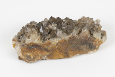
Geological specimen - Smoky quartz crystals, unknown
... ...quartz reefs beechworth...Geological Specimen geology Geology Collection Burke Museum Beechworth microcrystalline quartz quartz mining quartz reefs beechworth smokey quartz crystals crystals crystalline silicon oxide brown colour igneous rocks magma Ashburton river Western Australia Marlborough Queensland Lune River Tasmania Kingsgate New South Wales NSW Smoky quartz / crystals /locality/ unknown / (needs a wash) /BB A large hand-sized quartz mineral with shades of brown and gray throughout. ...Quartz is an extremely common mineral to find across the world. Quartz can have two forms; Microcrystalline quartz or Crystalline quartz. Microcrystalline quartz is a fine grain quartz where crystalline quartz is often a large crystal. This specimen is a crystalline quartz. Made of silicon oxide, this specimen is called smokey quartz crystals because of its brownish colour. However, the colour of quartz can vary. In addition, quartz are formed in deep-seated igneous rocks and crystallized through hot aqueous solutions. This type of crystal can be found all over Australia, including Beechworth in Victoria. Other places quartz can be found is the Ashburton River area in Western Australia, Marlborough in Queensland, the Lune River area in Tasmania and Kingsgate in New South Wales. This specimen is significant because it is common to find this kind of mineral. While the location of where this specimen was originally from is unknown, it highlights the many places in Australia where quartz is found. It demonstrates that quartz makes up a large portion of Australia's geology. In addition, quartz itself can vary in its colour and shape. This specimen represents one of these variations. That being smoky quartz crystals. This specimen is part of a larger collection of geological and mineral specimens collected from around Australia (and some parts of the world) and donated to the Burke Museum between 1868-1880. A large percentage of these specimens were collected in Victoria as part of the Geological Survey of Victoria that begun in 1852 (in response to the Gold Rush) to study and map the geology of Victoria. Collecting geological specimens was an important part of mapping and understanding the scientific makeup of the earth. Many of these specimens were sent to research and collecting organisations across Australia, including the Burke Museum, to educate and encourage further study.A large hand-sized quartz mineral with shades of brown and gray throughout.Smoky quartz / crystals /locality/ unknown / (needs a wash) /BBgeological specimen, geology, geology collection, burke museum, beechworth, microcrystalline, quartz, quartz mining, quartz reefs beechworth, smokey quartz crystals, crystals, crystalline, silicon oxide, brown, colour, igneous rocks, magma, ashburton river, western australia, marlborough, queensland, lune river, tasmania, kingsgate, new south wales, nsw -
 Ringwood and District Historical Society
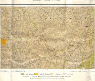
Map, Geological Survey of Victoria - County of Evelyn, Published June 1893
... Markings include soil and rock types, alluvial gold workings, quartz reefs....Markings include soil and rock types, alluvial gold workings, quartz reefs. Geological Survey of Victoria - County of Evelyn, Published June 1893 Map ...Markings include soil and rock types, alluvial gold workings, quartz reefs.Published under the direction of A.W. Howitt F.G.S. Secretary for Mines. The Hon J.H. McColl, Minister of Mines, June 1893. Surveyed by R.A. Moon, Field Geologist, under the supervision of R.A.F. Murray, Govt Geologist. Lithographed by J. M. Coakley. -
Stawell Historical Society Inc
Photograph, Fraser Park Mining Equipment, 15/03/2000
... 8 Colour Photographs showing equipment used in mining the Quartz Reef mines...Stawell Historical Society Inc 46 Longfield St Stawell grampians 7079: Fraser Park Sign. 7079a Steam Winding Engine and Bucket. 7079b Showing three items from a distance. 7079c Same as 7079b but from a differnt angle. 7079d Bailing Tank, Cage and Truck. 7079e Same as 7079a but from the other side. 7079f Gig and Rake 7079g Same as 7079f but from a different angle Gold Mining 8 Colour Photographs showing equipment used in mining the Quartz Reef mines Fraser Park Mining Equipment Photograph ...7079: Fraser Park Sign. 7079a Steam Winding Engine and Bucket. 7079b Showing three items from a distance. 7079c Same as 7079b but from a differnt angle. 7079d Bailing Tank, Cage and Truck. 7079e Same as 7079a but from the other side. 7079f Gig and Rake 7079g Same as 7079f but from a different angle8 Colour Photographs showing equipment used in mining the Quartz Reef minesgold mining -
 Federation University Historical Collection
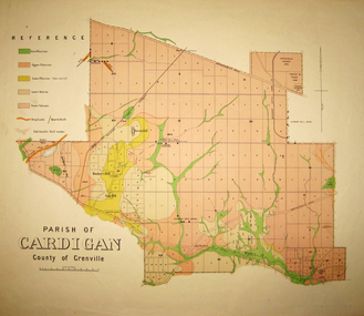
Map - Geological survey, Parish of Cardigan, County of Grenville, c1889
... Geological map of the Parish of Cardigan on a cadastral base showing quartz reefs, shafts, alluvial deposits....cardigan winter's creek ballarat cattle yards railway prince of wales park, ballarat friendly societies reserve ballarat industrial school reserve green hill bunker's hill sago hill diamond drill bores cardigan propriety half way house ti tree creek albion consols prince imperial winter's freehold company Geological map of the Parish of Cardigan on a cadastral base showing quartz reefs, shafts, alluvial deposits. Parish of Cardigan, County of Grenville Map Geological survey ...Geological map of the Parish of Cardigan on a cadastral base showing quartz reefs, shafts, alluvial deposits.cardigan, winter's creek, ballarat cattle yards railway, prince of wales park, ballarat, friendly societies reserve, ballarat industrial school reserve, green hill, bunker's hill, sago hill, diamond drill bores, cardigan propriety, half way house, ti tree creek, albion consols, prince imperial, winter's freehold company -
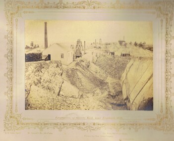 Bendigo Historical Society Inc.
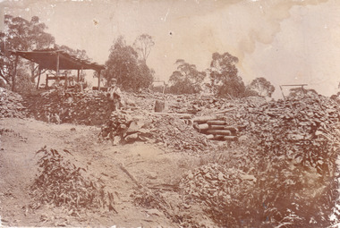
Photograph - VIEWS OF BENDIGO: EXCAVATION OF QUARTZ REEF NEAR IRONBARK HILL, c. 1870s
... VIEWS OF BENDIGO: EXCAVATION OF QUARTZ REEF NEAR IRONBARK HILL...Photograph No. 7: Excavation of Quartz Reef near ironbark hill (three copies)...Photograph No. 7: Excavation of Quartz Reef near ironbark hill (three copies) Photograph VIEWS OF BENDIGO: EXCAVATION OF QUARTZ REEF NEAR IRONBARK HILL ...Sepia toned photograph. Photograph No. 7: Excavation of Quartz Reef near ironbark hill (three copies)N.J. Cairetopic, mining, battery -
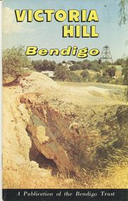 Bendigo Historical Society Inc.
Book - VICTORIA HILL BENDIGO, 1972
... History of Victoria Hill, Bendigo Gold mining on the 'richest quartz reef in Bendigo from 1854 to 1916.' A Publication of the National Trust. ...History of Victoria Hill, Bendigo Gold mining on the 'richest quartz reef in Bendigo from 1854 to 1916.' A Publication of the National Trust. ...Victoria Hill Bendigo. History of Victoria Hill, Bendigo Gold mining on the 'richest quartz reef in Bendigo from 1854 to 1916.' A Publication of the National Trust. With IndexBendigo Trustbendigo, mining, victoria hill, bendigo, goldmining -
 Federation University Historical Collection
Map, Ballaarat Gold Field, 1861, 1861
... Blue dots indicate gold leads, and red lines indicate auriferous quartz reef and outcrops of quartz veins....Blue dots indicate gold leads, and red lines indicate auriferous quartz reef and outcrops of quartz veins. Ballaarat Gold Field, 1861 Map Geological Survey of Victoria Robert Davidson Esq C.E. ...A party of surveyors camped by Yuille's Swamp (later Lake Wendouree) and surveyed the countryside for a map to be produced by the Geological Survey of Victoria. In November 2004 the Central Highlands Regional Library presented a special edition of 200 copies of the 1861 map reproduced from a copy in their collection. Original 1861 map of Ballarat showing streets and leads. Blue dots indicate gold leads, and red lines indicate auriferous quartz reef and outcrops of quartz veins."Compiled & Drawn from the Survey of Mining Surveyors Davidson, Fitzpatrick and Cowan & the Plans in the Surveyor General's Office by J. Brahe, 21st October 1861. R. Brough Smyth, Secretary for Mines. The Honourable J.B. Humffray, M.L.A. Commr of Mines.”ballarat, map, ballarat east, lake wendouree, survey, mines, robert davidson, ballarat gold field 1861, yuille's swamp, wendouree swamp, little bendigo diggings, gold leads, old post office hill, specimen hill, bakery hill, black hill, dead horse creek, brown hill, pennyweight hill, clayton hill, soldiers hill, golden point, gum tree flat, white flat, poverty hill, chinese village, robert brough smyth, ballarat map 1861, ballaarat vineyard, dead horse gully, deadhorse creek, invermay, black hill flat, gaelic church, police reserve, magpie range, dalton's flat, caadian lead, rifle butts, powder magazine, bathing house, government camp, gold office, chinese, llanberrris, victoria theatre, charlie napier hotel, united states hotel, grape's hoel, clayton's hill, cattleyard hill, free trade hotel, esmond lead, bakery hill, black hill lead, juvenile reformatory, ballarat orphanage, lady barkly lead, triffet's slaughter yard, little bendigo, melbourne road, t. cowan, thomas cowan -
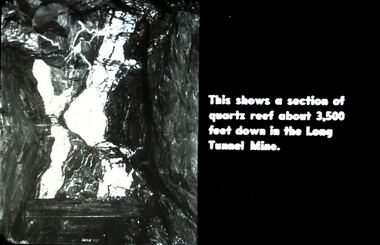 Bendigo Historical Society Inc.
Slide - DIGGERS & MINING. DIGGERS AND MINERS, c1930s-1940s
... This shows a section of quartz reef about 3.500 feet down in the Long Tunnel Mine. ...This shows a section of quartz reef about 3.500 feet down in the Long Tunnel Mine. ...Diggers & Mining. Diggers and Miners. This shows a section of quartz reef about 3.500 feet down in the Long Tunnel Mine. Markings: 34 994.5 WAL. Used as a teaching aid.hanimounteducation, tertiary, goldfields -
 Bendigo Historical Society Inc.
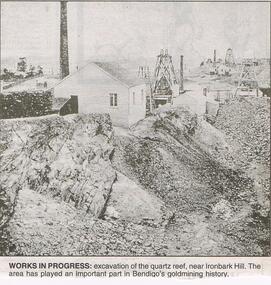
Newspaper - JENNY FOLEY COLLECTION: WORKS IN PROGRESS
... Works in progress: excavation of the quartz reef, near Ironbark Hill. The area has played an important part in Bendigo's goldmining history....Works in progress: excavation of the quartz reef, near Ironbark Hill. The area has played an important part in Bendigo's goldmining history. ...Bendigo Advertiser "the way we were" from 1999. Works in progress: excavation of the quartz reef, near Ironbark Hill. The area has played an important part in Bendigo's goldmining history.newspaper, bendigo advertiser, the way we were -
 Federation University Historical Collection
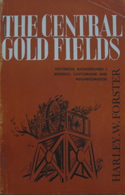
Book, Harley W. Forster, The Central Goldfields, 1969
... Topics include gold, McIvor diggings, Tarrangower goldfields, Maldon, quartz reefs, Chinese, land selection, Mt Alexander, Castlemaine, gold licence agitation, glossary. ...Topics include gold, McIvor diggings, Tarrangower goldfields, Maldon, quartz reefs, Chinese, land selection, Mt Alexander, Castlemaine, gold licence agitation, glossary. ...Brown covered book of 80 pages. Topics include gold, McIvor diggings, Tarrangower goldfields, Maldon, quartz reefs, Chinese, land selection, Mt Alexander, Castlemaine, gold licence agitation, glossary. gold license, gold licence, castlemaine, goldfield agitation -
 Bendigo Historical Society Inc.
Slide - DIGGERS & MINING. DIGGERS AND MINERS, c1850s
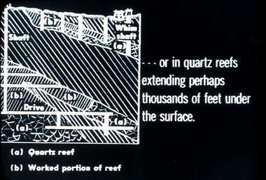
... A diagram; - - - or in quartz reefs extending perhaps thousands of feet under the surface. ...A diagram; - - - or in quartz reefs extending perhaps thousands of feet under the surface. ...BHS CollectionDiggers & Mining. Diggers and miners. A diagram; - - - or in quartz reefs extending perhaps thousands of feet under the surface. (a) Quartz (b) Worked portion of reef. Markings: 24 994:LIF I. Used as a teaching aid.hanimounteducation, tertiary, goldfields -
 Bendigo Historical Society Inc.
Document - Kangaroo Flat Gold Mine Collection: Psychology of Mine Development on Bendigo Goldfield, 19th century, Bendigo Mining NL, Unknown
... quartz mining...synclinal reefs...reefs 2. Mining methods 3. Deep mining 4. The age of the owners and managers 5. Capital raising 7. Management structures 8. Attitudes to machinery 9. The size of claims and leases 10 Conclusions Doug Buerger Gustave Thureau quartz mining synclinal reefs New Chum Railway Victoria Quartz Great Extended Hustlers Deborah Mines Innovation Eleven page paper titled 'The Psychology of Mine Development on the Bendigo goldfield in the nineteenth century'. ...Eleven page paper titled 'The Psychology of Mine Development on the Bendigo goldfield in the nineteenth century'. Initial discussion refers to Mr. Doug Buerger of Bendigo Mining N.L commenting that the central Bendigo goldfield had a 'further ten million ounces of gold' remaining 'to be extracted from beneath the old workings'. Further paragraphs include: 1. Non-development of the synclinal reefs 2. Mining methods 3. Deep mining 4. The age of the owners and managers 5. Capital raising 6. Attitude to innovation - reference to George Lansell and Gustave Thureau 7. Management structures 8. Attitudes to machinery 9. The size of claims and leases 10. Conclusionsbendigo mining n.l., bendigo, mining, gold, kangaroo flat, 1. non-development of the synclinal reefs, 2. mining methods, 3. deep mining, 4. the age of the owners and managers, 5. capital raising, 7. management structures, 8. attitudes to machinery, 9. the size of claims and leases, 10 conclusions, doug buerger, gustave thureau, quartz mining, synclinal reefs, new chum railway, victoria quartz, great extended hustlers, deborah mines, innovation