
Showing 6 items matching "queenscliff channel"
-
 Queenscliffe Maritime Museum
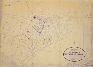
Map - Survey Chart, J. P. Larkin, Re-Survey of Queenscliff Channel, 29 October 1928
... Re-Survey of Queenscliff Channel...Queenscliff Channel...A paper chart showing sounding around the Queenscliff Channel dated 1928...Victoria Port Phillip October 1928, Re survey of Queenscliff Channel...Queenscliff Channel Surveying Navigation Victoria Port Phillip October 1928, Re survey of Queenscliff Channel A paper chart showing sounding around the Queenscliff Channel dated 1928 Re-Survey of Queenscliff Channel Map Survey Chart J. ...A paper chart showing sounding around the Queenscliff Channel dated 1928Victoria Port Phillip October 1928, Re survey of Queenscliff Channelqueenscliff channel, surveying, navigation -
 Queenscliffe Maritime Museum
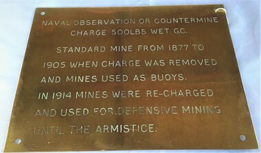
Plaque - Plaque, brass inscribed with Naval countermine information
... The scheme, involving massive expenditure, comprised a forward defence system of forts at Port Phillip heads dominated by Fort Queenscliff and South Channel Fort (artificial island), and a network of coastal batteries. ...The scheme, involving massive expenditure, comprised a forward defence system of forts at Port Phillip heads dominated by Fort Queenscliff and South Channel Fort (artificial island), and a network of coastal batteries. ...Found in garden shed of Mr Harry Barratt [WWI Gallipoli] and donated by his grandson. In 1877 Swan island was designed to defend shipping in Port Phillip and Hobson's Bays. The scheme, involving massive expenditure, comprised a forward defence system of forts at Port Phillip heads dominated by Fort Queenscliff and South Channel Fort (artificial island), and a network of coastal batteries. Some development of fortification had occurred in the 1850s, but it was the impetus of the Jervois-Scratchley reports which led to major work being undertaken in the 1880s. The overall defence plan involved a combination of guns, mines (known as electric torpedo) and ships to defend the entrance to Port Phillip Bay. Swan Island Fort would be used to protect the minefields in the harbour, Naval observation countermine charge 500lbs wet G.C Standard mine from 1877 to 1905 when charge was removed and mines used as buoys. In 1914 mines were recharged and used for defensive mining until Armistice.Brass plaque inscribed with information on naval countermineNaval observation or countermine charge 500lbs wet G.C. Standard mine from 1877 to 1905 when charge was removed and mines used as buoys. In 1914 mines were recharged and used for defensive mining until the Armistice.sea mine, plaque, pre wwi, naval countermine, swan island -
 Queenscliffe Maritime Museum
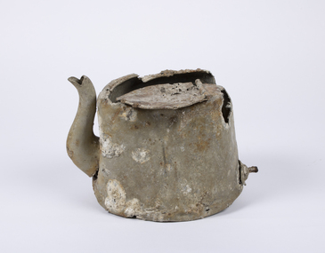
Domestic object - Teapot
... HMAS Goorangai had finished mine sweeping duties and after resupply was crossing from Queenscliff to Point Nepean to seek better anchorage due to impending bad weather. At around 20:30 on the 20th of November 1940 the 10,400-ton MV Duntroon was transiting the South Channel on her way to Sydney from Perth via Melbourne carrying 65 passengers and general and perishable cargo. ...HMAS Goorangai had finished mine sweeping duties and after resupply was crossing from Queenscliff to Point Nepean to seek better anchorage due to impending bad weather. At around 20:30 on the 20th of November 1940 the 10,400-ton MV Duntroon was transiting the South Channel on her way to Sydney from Perth via Melbourne carrying 65 passengers and general and perishable cargo. ...In 1940, German minefields were laid in east and west Bass Strait which quickly claimed merchant ships Cambridge (British) and the City of Rayville (American). HMAS Goorangai had finished mine sweeping duties and after resupply was crossing from Queenscliff to Point Nepean to seek better anchorage due to impending bad weather. At around 20:30 on the 20th of November 1940 the 10,400-ton MV Duntroon was transiting the South Channel on her way to Sydney from Perth via Melbourne carrying 65 passengers and general and perishable cargo. It struck HMAS Goorangai forward of the funnel on the port side and cut her in two. At about 20:45 HMAS Goorangai sank in less than a minute resulting in the loss of her whole ship’s company, a complement of 24 officers and sailors.HMAS Goorangai was the first Royal Australian Navy (RAN) ship lost in WWII, the first RAN surface ship lost in wartime, and the first RAN surface ship lost with all hands. A memorial cairn was erected at Queenscliff in 1981 and a service of commemoration is held there every year.A severely damaged and corroded aluminium teapot recovered from the wreck of HMAS Goorangaihmas goorangai, wwii, collision at sea -
 Queenscliffe Maritime Museum
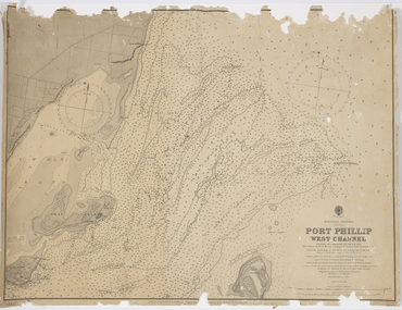
Map - Survey Charts, Port Phillip West Channel
... Queenscliff. Earlier chart does not show the cut which can be seen in the later chart. The creation of the cut and subsequebt dredging of it has changed the shoreline due to shifting sand. Port Phillip Queencliff Channel ...These charts show changes to the depth levels surrounding Queenscliff. Earlier chart does not show the cut which can be seen in the later chart. The creation of the cut and subsequebt dredging of it has changed the shoreline due to shifting sand.Two charts of the Port Phillip West Channel, reference number 309. One was engraved in 1903, the other a new 1935 edition last revised in 1961.Port Phillip West Channelport phillip, queencliff channel, charts, soundings -
![Rear [inside] view of a brass lock with key from the Port and Harbours suction dredge 'Pioneer' used at the Queenscliff creek entrance](/media/collectors/4f729f7e97f83e03086018d1/items/5f855cde425f7f235017d662/item-media/612dad24e8448ba3f69e3419/item-fit-380x285.jpg?cb=6) Queenscliffe Maritime Museum
Queenscliffe Maritime MuseumFunctional object - Lock, door, brass
... QUEENSCLIFF, Thursday. - After a series of successful experiments in dredging the eastern end of the South Channel, the suction dredge Pioneer sailed this after-noon for the Gippsland Lakes, where work awaits her. ...QUEENSCLIFF, Thursday. - After a series of successful experiments in dredging the eastern end of the South Channel, the suction dredge Pioneer sailed this after-noon for the Gippsland Lakes, where work awaits her. ...The Argus Melbourne Friday 10 July 1908 QUEENSCLIFF, Thursday. - After a series of successful experiments in dredging the eastern end of the South Channel, the suction dredge Pioneer sailed this after-noon for the Gippsland Lakes, where work awaits her. During operations in the South Channel the dredge worked on a sandy and shell bottom in depths ranging from 35ft. to 40ft. with unqualified success, performing the work much quicker and cheaper than the bucket drudge John Nimmo, which is still employed. Captain Macarthur was in charge of the operations.Brass lock from Port and Harbours suction dredge 'Pioneer' used at the Queenscliff creek entrance door lock, suction dredge, pioneer -
![Survey metal tape on reel with leather bag. 10 yards in length, the metal chain is subdivided every 10 links [2.2 yards].](/media/collectors/4f729f7e97f83e03086018d1/items/5f87f8fd13cca91a6c1db65a/item-media/615a8287eb51660bb8dc9e31/item-fit-380x285.jpg?cb=6) Queenscliffe Maritime Museum
Queenscliffe Maritime MuseumInstrument - Survey tape on metal reel in leather bag with other articles
... He worked in Port Phillip and Queenscliff related surveys [e.g. Western channel, Queenscliff channel]. surveying equipment j p larkin Made by A.E. ...A surveyors chain is actually a thin steel band on a reel and is used for accurate measurements. This 110 yard [101m] chain is subdivided every 10 links [2.2 yards or 2m]Items belonged to J P Larkin Government marine surveyor who worked on surveys up to 1938. He worked in Port Phillip and Queenscliff related surveys [e.g. Western channel, Queenscliff channel].Survey tape on metal reel in leather bag with other articles: plumb bobs, number pegs, drawing instruments in box and steel punchesMade by A.E. Parsons surveying instruments, 215 Queen Street Melbournesurveying equipment, j p larkin
