Showing 16 items matching "radio / navigation aids"
-
 Moorabbin Air Museum
Manual (Item) - Private Pilot Navigation Volume 1 , Basic Navigation Theory , Radio Navigation Aids
... Private Pilot Navigation Volume 1 , Basic Navigation Theory , Radio Navigation Aids...Private Pilot Navigation Volume 1 , Basic Navigation Theory , Radio Navigation Aids...Moorabbin Air Museum Moorabbin Airport 12 First Street Moorabbin melbourne Private Pilot Navigation Volume 1 , Basic Navigation Theory , Radio Navigation Aids Manual Private Pilot Navigation Volume 1 , Basic Navigation Theory , Radio Navigation Aids ... -
Moorabbin Air Museum
Manual (item) - Air Navigation vol 5 Radio Navigation Aids - RAF Air Ministry Oct 1947
... Air Navigation vol 5 Radio Navigation Aids - RAF Air Ministry Oct 1947...Air Navigation vol 5 Radio Navigation Aids - RAF Air Ministry Oct 1947...Moorabbin Air Museum Moorabbin Airport 12 First Street Moorabbin melbourne Air Navigation vol 5 Radio Navigation Aids - RAF Air Ministry Oct 1947 Manual Air Navigation vol 5 Radio Navigation Aids - RAF Air Ministry Oct 1947 ... -
Moorabbin Air Museum
Manual (item) - Instrument Rating Course, Instrument Rating Course Part 1 - radio navigation aids
... Instrument Rating Course Part 1 - radio navigation aids...Moorabbin Air Museum Moorabbin Airport 12 First Street Moorabbin melbourne Instrument Rating Course Part 1 - radio navigation aids Manual Instrument Rating Course ... -
Moorabbin Air Museum
Manual (Item) - The Instrument Rating Manual ,Instrument Flying Techniques , Radio Navigation Aids , Preparing For An IFR Flight , IFR Operations , Meteorology, The Instrument Rating Manual
... The Instrument Rating Manual ,Instrument Flying Techniques , Radio Navigation Aids , Preparing For An IFR Flight , IFR Operations , Meteorology...Moorabbin Air Museum Moorabbin Airport 12 First Street Moorabbin melbourne The Instrument Rating Manual Manual The Instrument Rating Manual ,Instrument Flying Techniques , Radio Navigation Aids , Preparing For An IFR Flight , IFR Operations , Meteorology ... -
Moorabbin Air Museum
Book - Instrument Flying, Instrument Pilot Exam Guide
... ...Radio / navigation aids...Moorabbin Air Museum Moorabbin Airport 12 First Street Moorabbin melbourne Instrument Flying Civil air regulations Radio / navigation aids Weather Instruments Sample exams Guide to exam for American FAA instrument pilot examination, circa 1964 Instrument Pilot Exam Guide Book Instrument Flying ...Guide to exam for American FAA instrument pilot examination, circa 1964non-fictionGuide to exam for American FAA instrument pilot examination, circa 1964civil air regulations, radio / navigation aids, weather, instruments, sample exams -
Moorabbin Air Museum
Book - Australian aviation year books, Australian Aviation Year Book 1967/68
... ...Radio navigation aids...Moorabbin Air Museum Moorabbin Airport 12 First Street Moorabbin melbourne Australian aviation year books Aerodromes & airfields Aero clubs & flying schools Approved firms Fleet air arm Aircraft leasing & hire purchase companies Airline operators Aircraft production Aircraft register Aerial work operators Charter operators Ground training colleges History of Australian aviation Insurance companies/brokers RAAF Radio navigation aids Guide to aviation industry throughout Australia & Papua New Guinea Australian Aviation Year Book 1967/68 Book Australian aviation year books ...Guide to aviation industry throughout Australia & Papua New Guineanon-fictionGuide to aviation industry throughout Australia & Papua New Guineaaerodromes & airfields, aero clubs & flying schools, approved firms, fleet air arm, aircraft leasing & hire purchase companies, airline operators, aircraft production, aircraft register, aerial work operators, charter operators, ground training colleges, history of australian aviation, insurance companies/brokers, raaf, radio navigation aids -
Moorabbin Air Museum
Manual - Ansett Boeing 727 operating manuals, Boeing 727 Operating Manual Section 3 Normal Operating Procedures March 1987
... ...Radio switching/tuning & navigation aids...Moorabbin Air Museum Moorabbin Airport 12 First Street Moorabbin melbourne Ansett Boeing 727 operating manuals Cockpit checks Pre flight checks Cockpit checklists & flight procedures Instrument flight procedures Adverse weather operations Ice & fire protection Radio switching/tuning & navigation aids System operation Checklists Overview of normal operating procedures for Boeing 727, circa 1987 Spiral bound book type manual Boeing 727 Operating Manual Section 3 Normal Operating Procedures March 1987 Manual Ansett Boeing 727 operating manuals ...Overview of normal operating procedures for Boeing 727, circa 1987Spiral bound book type manualnon-fictionOverview of normal operating procedures for Boeing 727, circa 1987cockpit checks, pre flight checks, cockpit checklists & flight procedures, instrument flight procedures, adverse weather operations, ice & fire protection, radio switching/tuning & navigation aids, system operation, checklists -
 Orbost & District Historical Society
map, 1985
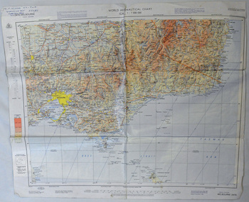
... Using these charts and other tools, pilots are able to determine their position, safe altitude, best route to a destination, navigation aids along the way, alternative landing areas in case of an in-flight emergency, and other useful information such as radio frequencies and airspace boundaries. ...Using these charts and other tools, pilots are able to determine their position, safe altitude, best route to a destination, navigation aids along the way, alternative landing areas in case of an in-flight emergency, and other useful information such as radio frequencies and airspace boundaries. ...An aeronautical chart is a map designed to assist in navigation of aircraft. Using these charts and other tools, pilots are able to determine their position, safe altitude, best route to a destination, navigation aids along the way, alternative landing areas in case of an in-flight emergency, and other useful information such as radio frequencies and airspace boundaries. World aeronautical charts have a scale of 1:1,000,000 and cover relatively large areas. Orbost Aero Club began in 1969 with Basil Dowie as Chair, David Nixon as Secretary/Treasurer. The group went into recess from 1977-1991 closing in 1997. The mid 1960s were boom years in flying training in Australia and the number of Aero Clubs grew rapidly. The Club played a significant role in the establishment of the small airport at Marlo and in the ongoing operation and development of the airport over the years particularly for patient transfer by aerial ambulance. The Orbost Aero Club Club played a significant role in the establishment of the small airport at Marlo and in the ongoing operation and development of the airport over the years.A laminated map of eastern Victoria. A World Aeronautical Chart. It shows elevations, longitude etc and is designed for pre-flight planning as well as pilotage. Top left hand corner - D.F.N.Nixon VH-FWD 12 Kristine Ct Cheletenham 27/7/87orbost-aero-club aeronautical-map -
 Mission to Seafarers Victoria
Book, Her Majesty's Stationery Office, Admiralty Manual of Navigation Vol.2, 1973
... Howard's involvement with the Mission was through with the First Fleet Fellowship Victoria Inc. and their meetings held at the Mission over many years. howard timbury first fleet fellowship victoria interest group navigation education This volume of the Admiralty Manual of Navigation describes off-shore navigation - the safe conduct of a ship across the open sea where, in general, hearings of objects on land cannot be obtained except by means of radio waves (i.e. using radio fixing aids). ...This volume of the Admiralty Manual of Navigation describes off-shore navigation - the safe conduct of a ship across the open sea where, in general, hearings of objects on land cannot be obtained except by means of radio waves (i.e. using radio fixing aids). The first chapters are mainly concerned with distances, courses, tracks and charts; then various methods of obtaining position lines and positions from astronomical observations are explained, including a rapid. method in the last chapter. The volume also contains an outline of meteorrology and weather forecasting.329 pages, illustrated, navy blue linen cover and red paper dust jacket.non-fictionThis volume of the Admiralty Manual of Navigation describes off-shore navigation - the safe conduct of a ship across the open sea where, in general, hearings of objects on land cannot be obtained except by means of radio waves (i.e. using radio fixing aids). The first chapters are mainly concerned with distances, courses, tracks and charts; then various methods of obtaining position lines and positions from astronomical observations are explained, including a rapid. method in the last chapter. The volume also contains an outline of meteorrology and weather forecasting.howard timbury, first fleet fellowship victoria, interest group, navigation, education -
 Mission to Seafarers Victoria
Book, Her Majesty's Stationery Office, Admiralty Manual of Navigation Vol.1, 1977
... navigation and meteorology can be read in Volume II of this manual. The quality of detailed thoroughness that has always distinguished this book is retained, and it has been brought up to date, particularly in the chapters on radio aids to navigation and navigational instruments. ...This revised edition follows the previous editions in giving a practical guide to navigation and pilotage which, although written primarily for naval officers, will be suitable for all students of navigation. Astronomical navigation and meteorology can be read in Volume II of this manual. The quality of detailed thoroughness that has always distinguished this book is retained, and it has been brought up to date, particularly in the chapters on radio aids to navigation and navigational instruments.544 pages, illustrated, navy blue linen cover and red paper dust jacket.non-fictionThis revised edition follows the previous editions in giving a practical guide to navigation and pilotage which, although written primarily for naval officers, will be suitable for all students of navigation. Astronomical navigation and meteorology can be read in Volume II of this manual. The quality of detailed thoroughness that has always distinguished this book is retained, and it has been brought up to date, particularly in the chapters on radio aids to navigation and navigational instruments.howard timbury, first fleet fellowship victoria, interest group, navigation, education -
Moorabbin Air Museum
Manual - RAAF flying manuals, Royal Australian Air Force Flying - Volume 3 Radio and Radar
... RAAF Flying manuals Communications Communications procedures Hyperbolic navigation systems Doppler navigation systems Airborne search radar Approach & landing aids Part of 10 volume general reference on flying , circa 1960 Royal Australian Air Force Flying - Volume 3 Radio and Radar Manual RAAF flying manuals ...Part of 10 volume general reference on flying , circa 1960non-fictionPart of 10 volume general reference on flying , circa 1960communications, communications procedures, hyperbolic navigation systems, doppler navigation systems, airborne search radar, approach & landing aids -
Moorabbin Air Museum
Book - Radio navigation, The VOR and ADF
... Radio navigation VOR ADF Background for understanding & use of VOR & ADF radio navigation aids, circa 1977 The VOR and ADF Book Radio navigation ...Background for understanding & use of VOR & ADF radio navigation aids, circa 1977non-fictionBackground for understanding & use of VOR & ADF radio navigation aids, circa 1977vor, adf -
Moorabbin Air Museum
Manual (item) - Communications Radio Navigational Aids
... Moorabbin Air Museum Moorabbin Airport 12 First Street Moorabbin melbourne RAAF Technical Training Communications Radio Navigational Aids Manual Communications Radio Navigational Aids ...RAAF Technical Training -
Moorabbin Air Museum
Book - Air navigation & radio, Radio Aids to Air Navigation
... Radio Aids to Air Navigation...Moorabbin Air Museum Moorabbin Airport 12 First Street Moorabbin melbourne Air navigation & radio General principles Medium frequency systems MF aids VHF systems Hyperbolic aids Pulse systems Air traffic control aids Approach & landing aids Future aids Charts/documents/regulations Review of civil radio systems applied to aircraft & their ground contacts, circa 1956 Radio Aids to Air Navigation Book Air navigation & radio ...Review of civil radio systems applied to aircraft & their ground contacts, circa 1956non-fictionReview of civil radio systems applied to aircraft & their ground contacts, circa 1956general principles, medium frequency systems, mf aids, vhf systems, hyperbolic aids, pulse systems, air traffic control aids, approach & landing aids, future aids, charts/documents/regulations -
Moorabbin Air Museum
Book - AIR TRAFFIC CONTROL, Take Off To Touchdown The Story of Air Traffic Control
... radio...War years...Post war boom...Navigation & control aids...Moorabbin Air Museum Moorabbin Airport 12 First Street Moorabbin melbourne Air traffic control The coming of radio War years Post war boom Navigation & control aids Area control Control tower Operational control Control of a flight Search & rescue Men of ATC Phonetic alphabet Air traffic control terms Technical & general overview of air traffic control in Australia, circa 1967 Take Off To Touchdown The Story of Air Traffic Control Book AIR TRAFFIC CONTROL ...Technical & general overview of air traffic control in Australia, circa 1967non-fictionTechnical & general overview of air traffic control in Australia, circa 1967the coming of radio, war years, post war boom, navigation & control aids, area control, control tower, operational control, control of a flight, search & rescue, men of atc, phonetic alphabet, air traffic control terms