Showing 51 items matching "radio navigation"
-
 Moorabbin Air Museum
Book - Radio navigation, Radio Navigation Volume 1 VOR: A Pilots' Guide to the VHF Omnirange
... Radio navigation...Radio Navigation Volume 1 VOR: A Pilots' Guide to the VHF Omnirange...Radio navigation...Radio navigation Multiple diagrams with technical explanations provided. ...Overview for pilots of very high frequency omni-directional range (VOR), circa 1971/1980May be duplicate itemnon-fictionOverview for pilots of very high frequency omni-directional range (VOR), circa 1971/1980multiple diagrams with technical explanations provided. -
Moorabbin Air Museum
Manual (Item) - Private Pilot Navigation Volume 1 , Basic Navigation Theory , Radio Navigation Aids
... Private Pilot Navigation Volume 1 , Basic Navigation Theory , Radio Navigation Aids...Private Pilot Navigation Volume 1 , Basic Navigation Theory , Radio Navigation Aids...Moorabbin Air Museum Moorabbin Airport 12 First Street Moorabbin melbourne Private Pilot Navigation Volume 1 , Basic Navigation Theory , Radio Navigation Aids Manual Private Pilot Navigation Volume 1 , Basic Navigation Theory , Radio Navigation Aids ... -
Moorabbin Air Museum
Manual (item) - Air Navigation vol 5 Radio Navigation Aids - RAF Air Ministry Oct 1947
... Air Navigation vol 5 Radio Navigation Aids - RAF Air Ministry Oct 1947...Air Navigation vol 5 Radio Navigation Aids - RAF Air Ministry Oct 1947...Moorabbin Air Museum Moorabbin Airport 12 First Street Moorabbin melbourne Air Navigation vol 5 Radio Navigation Aids - RAF Air Ministry Oct 1947 Manual Air Navigation vol 5 Radio Navigation Aids - RAF Air Ministry Oct 1947 ... -
Moorabbin Air Museum
Book - Radio navigation, The VOR and ADF
... Radio navigation...Radio navigation...Radio navigation VOR ADF Background for understanding & use of VOR & ADF radio navigation aids, circa 1977 The VOR and ADF Book Radio navigation ...Background for understanding & use of VOR & ADF radio navigation aids, circa 1977non-fictionBackground for understanding & use of VOR & ADF radio navigation aids, circa 1977vor, adf -
 Bendigo Military Museum
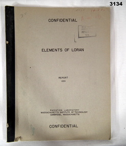
Manual - RADIO NAVIGATION, Radiator Laboratory, Massachusetts Institute of Technology, Elements of LORAN, Report 499, 1944
... RADIO NAVIGATION...LORAN is a radio navigation system....Bendigo Military Museum 37 - 39 Pall Mall Bendigo goldfields LORAN is a radio navigation system. books reference/military/manuals radio Some random numbers written on front top right. ...LORAN is a radio navigation system.Marked Confidential. Khaki coloured soft cover book with black print. Illustrated with drawings, charts, mathematics, 45 pages.Some random numbers written on front top right.books reference/military/manuals, radio -
Moorabbin Air Museum
Book - Air navigation & radio, Radio Aids to Air Navigation
... Air navigation & radio...Radio Aids to Air Navigation...Air navigation & radio...Moorabbin Air Museum Moorabbin Airport 12 First Street Moorabbin melbourne Air navigation & radio General principles Medium frequency systems MF aids VHF systems Hyperbolic aids Pulse systems Air traffic control aids Approach & landing aids Future aids Charts/documents/regulations Review of civil radio systems applied to aircraft & their ground contacts, circa 1956 Radio Aids to Air Navigation Book Air navigation & radio ...Review of civil radio systems applied to aircraft & their ground contacts, circa 1956non-fictionReview of civil radio systems applied to aircraft & their ground contacts, circa 1956general principles, medium frequency systems, mf aids, vhf systems, hyperbolic aids, pulse systems, air traffic control aids, approach & landing aids, future aids, charts/documents/regulations -
Moorabbin Air Museum
Manual (Item) - RAAF - Macchi MB326-H Aircraft General And Technical Information Radio Communications And Navigation Systems, Macchi MB326-H Aircraft General And Technical Information Radio Communications And Navigation Systems
... RAAF - Macchi MB326-H Aircraft General And Technical Information Radio Communications And Navigation Systems...Macchi MB326-H Aircraft General And Technical Information Radio Communications And Navigation Systems...Moorabbin Air Museum Moorabbin Airport 12 First Street Moorabbin melbourne AAP 7212-001-2-7 Macchi MB326-H Aircraft General And Technical Information Radio Communications And Navigation Systems Manual RAAF - Macchi MB326-H Aircraft General And Technical Information Radio Communications And Navigation Systems ...AAP 7212-001-2-7 -
Moorabbin Air Museum
Book - VOR, W. R. Evans, RADIO NAVIGATION VOLUME 1, 1071
... RADIO NAVIGATION VOLUME 1...RADIO NAVIGATION VOLUME 1 Book VOR W. R. Evans AUSTRALIA AND NEW ZEALAND BOOK COMPANY ... -
Moorabbin Air Museum
Manual (item) - Instrument Rating Course, Instrument Rating Course Part 1 - radio navigation aids
... Instrument Rating Course Part 1 - radio navigation aids...Moorabbin Air Museum Moorabbin Airport 12 First Street Moorabbin melbourne Instrument Rating Course Part 1 - radio navigation aids Manual Instrument Rating Course ... -
Moorabbin Air Museum
Book (item), W. R. Evans, Radio Navigation Volume 1 VOR: A Pilots' Guide to the VHF Omnirange, 1971
... Radio Navigation Volume 1 VOR: A Pilots' Guide to the VHF Omnirange...A5-sized hardcover book with a red and black cover Radio Navigation Volume 1 VOR: A Pilots' Guide to the VHF Omnirange Book W. ...Sticker on the front provides an owner, Moorabbin Aircraft SPares Pty. Ltd., and a customer (borrower or buyer?), L. Gilbert. -
Moorabbin Air Museum
Book - Flight training for private pilots, Flying Training For The Private Pilot Licence Instrument Flying, Radio Navigation, Instrument Approach Procedure
... Flying Training For The Private Pilot Licence Instrument Flying, Radio Navigation, Instrument Approach Procedure...Moorabbin Air Museum Moorabbin Airport 12 First Street Moorabbin melbourne Flight Training Flight traning for private pilots Study guide on instrument flying, radio navigation & instrument approach procedure for private pilots circa 1980s Flying Training For The Private Pilot Licence Instrument Flying, Radio Navigation, Instrument Approach Procedure Book Flight training for private pilots ...Study guide on instrument flying, radio navigation & instrument approach procedure for private pilots circa 1980snon-fictionStudy guide on instrument flying, radio navigation & instrument approach procedure for private pilots circa 1980sflight traning for private pilots -
Moorabbin Air Museum
Map (Item) - Maps of Northern Australia and New Guinea, AUS RNC 5 and 6 radio navigation maps
... AUS RNC 5 and 6 radio navigation maps...Moorabbin Air Museum Moorabbin Airport 12 First Street Moorabbin melbourne AUS RNC 5 and 6 radio navigation maps Map Maps of Northern Australia and New Guinea ... -
Moorabbin Air Museum
Manual (Item) - Private Pilot Licence - Volume 1 , Basic Navigation Theory , Radio Navaids
... Private Pilot Licence - Volume 1 , Basic Navigation Theory , Radio Navaids...Private Pilot Licence - Volume 1 , Basic Navigation Theory , Radio Navaids...Moorabbin Air Museum Moorabbin Airport 12 First Street Moorabbin melbourne Private Pilot Licence - Volume 1 , Basic Navigation Theory , Radio Navaids Manual Private Pilot Licence - Volume 1 , Basic Navigation Theory , Radio Navaids ... -
Moorabbin Air Museum
Manual (Item) - The Instrument Rating Manual ,Instrument Flying Techniques , Radio Navigation Aids , Preparing For An IFR Flight , IFR Operations , Meteorology, The Instrument Rating Manual
... The Instrument Rating Manual ,Instrument Flying Techniques , Radio Navigation Aids , Preparing For An IFR Flight , IFR Operations , Meteorology...Moorabbin Air Museum Moorabbin Airport 12 First Street Moorabbin melbourne The Instrument Rating Manual Manual The Instrument Rating Manual ,Instrument Flying Techniques , Radio Navigation Aids , Preparing For An IFR Flight , IFR Operations , Meteorology ... -
Moorabbin Air Museum
Manual (Item) - Porter Aircraft Communications And Radio Navigation Systems Maintenance Manual
... Porter Aircraft Communications And Radio Navigation Systems Maintenance Manual...Manual Porter Aircraft Communications And Radio Navigation Systems Maintenance Manual ...Description: Published 1/5/61. Published by Piper Aircraft Corporation. 256 pages. Piper PA23 Apache Aircraft Service Manual Level of Importance: World. -
 Moorabbin Air Museum
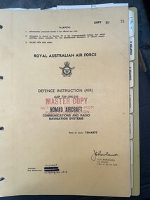
Manual (item) - (SP) AAP 7211.016-2-6 Nomad Aircraft Communications and Radio Navigation Systems
... (SP) AAP 7211.016-2-6 Nomad Aircraft Communications and Radio Navigation Systems...Moorabbin Air Museum Moorabbin Airport 12 First Street Moorabbin melbourne Manual (SP) AAP 7211.016-2-6 Nomad Aircraft Communications and Radio Navigation Systems ... -
Moorabbin Air Museum
Book - Instrument Flying, Instrument Pilot Exam Guide
... ...Radio / navigation aids...Moorabbin Air Museum Moorabbin Airport 12 First Street Moorabbin melbourne Instrument Flying Civil air regulations Radio / navigation aids Weather Instruments Sample exams Guide to exam for American FAA instrument pilot examination, circa 1964 Instrument Pilot Exam Guide Book Instrument Flying ...Guide to exam for American FAA instrument pilot examination, circa 1964non-fictionGuide to exam for American FAA instrument pilot examination, circa 1964civil air regulations, radio / navigation aids, weather, instruments, sample exams -
Moorabbin Air Museum
Book - Australian aviation year books, Australian Aviation Year Book 1967/68
... ...Radio navigation aids...Moorabbin Air Museum Moorabbin Airport 12 First Street Moorabbin melbourne Australian aviation year books Aerodromes & airfields Aero clubs & flying schools Approved firms Fleet air arm Aircraft leasing & hire purchase companies Airline operators Aircraft production Aircraft register Aerial work operators Charter operators Ground training colleges History of Australian aviation Insurance companies/brokers RAAF Radio navigation aids Guide to aviation industry throughout Australia & Papua New Guinea Australian Aviation Year Book 1967/68 Book Australian aviation year books ...Guide to aviation industry throughout Australia & Papua New Guineanon-fictionGuide to aviation industry throughout Australia & Papua New Guineaaerodromes & airfields, aero clubs & flying schools, approved firms, fleet air arm, aircraft leasing & hire purchase companies, airline operators, aircraft production, aircraft register, aerial work operators, charter operators, ground training colleges, history of australian aviation, insurance companies/brokers, raaf, radio navigation aids -
Moorabbin Air Museum
Book - Private pilot manuals, Private Pilot Manual
... ...Radio navigation...Meteorology Air navigation Radio navigation Aviation physiology Pre flight planning Training textbook for private pilots, circa 1991 Private Pilot Manual Book Private pilot manuals ...Training textbook for private pilots, circa 1991non-fictionTraining textbook for private pilots, circa 1991principles of flight, the flight environment, aircraft systems & performance., meteorology, air navigation, radio navigation, aviation physiology, pre flight planning -
Moorabbin Air Museum
Book - A Text Book on Aviation Volume 4 Navigation, Meteorology, Radio Beam Flying and Orientation Procedure, Leslie Thorpe
... A Text Book on Aviation Volume 4 Navigation, Meteorology, Radio Beam Flying and Orientation Procedure ...Moorabbin Air Museum Moorabbin Airport 12 First Street Moorabbin melbourne Leslie Thorpe Book A Text Book on Aviation Volume 4 Navigation, Meteorology, Radio Beam Flying and Orientation Procedure ... -
Moorabbin Air Museum
Manual (item) - Aeronautical Information Publication Department of Civil Aviation, Aeronautical Information Publication
... DCA publications for pilots covering Communication and Radio Navigation Services - See Media for Contents ...DCA publications for pilots covering Communication and Radio Navigation Services - See Media for Contents Aeronautical Information Publication Manual Aeronautical Information Publication Department of Civil Aviation ...DCA publications for pilots covering Communication and Radio Navigation Services - See Media for Contents -
Moorabbin Air Museum
Magazine (Item) - Deleted
... Description: Models EMB-110K1 EMB-110P1 EMB-110 P2 Technical Radio Navigation T.O.IC95A-2-9 Level of Importance: . ...Moorabbin Air Museum Moorabbin Airport 12 First Street Moorabbin melbourne Description: Models EMB-110K1 EMB-110P1 EMB-110 P2 Technical Radio Navigation T.O.IC95A-2-9 Level of Importance: . ...Description: Models EMB-110K1 EMB-110P1 EMB-110 P2 Technical Radio Navigation T.O.IC95A-2-9 Level of Importance: . Historical Details: Missing Jan 1968 to Dec 1977 -
Moorabbin Air Museum
Manual - Ansett Boeing 727 operating manuals, Boeing 727 Operating Manual Section 3 Normal Operating Procedures March 1987
... ...Radio switching/tuning & navigation aids...Moorabbin Air Museum Moorabbin Airport 12 First Street Moorabbin melbourne Ansett Boeing 727 operating manuals Cockpit checks Pre flight checks Cockpit checklists & flight procedures Instrument flight procedures Adverse weather operations Ice & fire protection Radio switching/tuning & navigation aids System operation Checklists Overview of normal operating procedures for Boeing 727, circa 1987 Spiral bound book type manual Boeing 727 Operating Manual Section 3 Normal Operating Procedures March 1987 Manual Ansett Boeing 727 operating manuals ...Overview of normal operating procedures for Boeing 727, circa 1987Spiral bound book type manualnon-fictionOverview of normal operating procedures for Boeing 727, circa 1987cockpit checks, pre flight checks, cockpit checklists & flight procedures, instrument flight procedures, adverse weather operations, ice & fire protection, radio switching/tuning & navigation aids, system operation, checklists -
Moorabbin Air Museum
Manual (Item) - (SP) Technical Manual Illustrated Parts Breakdown Electrical System Aircraft: Bandeirante T.O.Emb110 P1-4
... Description: Radio communications Navigation Systems EMB 110P1 Publisher: Embraer Level of Importance: World. ...Moorabbin Air Museum Moorabbin Airport 12 First Street Moorabbin melbourne Description: Radio communications Navigation Systems EMB 110P1 Publisher: Embraer Level of Importance: World. ...Description: Radio communications Navigation Systems EMB 110P1 Publisher: Embraer Level of Importance: World. RAAF -
 Sunshine and District Historical Society Incorporated
Audio - Sunshine And District Historical Society Pioneers Dinner 2005 Audio Tape 2, Sunshine and District Historical Society Inc, 2005
... Guest speakers Norm Carlton and Ray Carlton 'Wartime experiences as navigators in the Air Force' During WW11 Air Force navigators used a combination of dead reckoning, celestial navigation and radio navigation to guide aircraft. Navigators underwent intensive training to build their skills and adapt to changing conditions including night and bad weather flights....Guest speakers Norm Carlton and Ray Carlton 'Wartime experiences as navigators in the Air Force' During WW11 Air Force navigators used a combination of dead reckoning, celestial navigation and radio navigation to guide aircraft. Navigators underwent intensive training to build their skills and adapt to changing conditions including night and bad weather flights. ...The Sunshine and District Historical Society Pioneers’ Lunch / Dinner is an annual event. It’s a commemorative gathering that honours the early settlers, people, community leaders of Sunshine and the surrounding district, events, achievements, etc. At the Pioneers’ Lunch / Dinner, a toast is a ritual and a dedicated moment to honour the original settlers and their contributions, and a guest speaker talks about an interesting subject. Guest speakers Norm Carlton and Ray Carlton 'Wartime experiences as navigators in the Air Force' During WW11 Air Force navigators used a combination of dead reckoning, celestial navigation and radio navigation to guide aircraft. Navigators underwent intensive training to build their skills and adapt to changing conditions including night and bad weather flights.ray carlton, norm carlton, world war 1939 - 1945 -
 Sunshine and District Historical Society Incorporated
Audio - Sunshine And District Historical Society Pioneers Dinner 2005 Audio Tape 1
... Guest speakers Norm Carlton and Ray Carlton 'Wartime experiences as navigators in the Air Force' During WW11 Air Force navigators used a combination of dead reckoning, celestial navigation and radio navigation to guide aircraft. Navigators underwent intensive training to build their skills and adapt to changing conditions including night and bad weather flights....Guest speakers Norm Carlton and Ray Carlton 'Wartime experiences as navigators in the Air Force' During WW11 Air Force navigators used a combination of dead reckoning, celestial navigation and radio navigation to guide aircraft. Navigators underwent intensive training to build their skills and adapt to changing conditions including night and bad weather flights. ...The Sunshine and District Historical Society Pioneers’ Lunch / Dinner is an annual event. It’s a commemorative gathering that honours the early settlers, people, community leaders of Sunshine and the surrounding district, events, achievements, etc. At the Pioneers’ Lunch / Dinner, a toast is a ritual and a dedicated moment to honour the original settlers and their contributions, and a guest speaker talks about an interesting subject. Guest speakers Norm Carlton and Ray Carlton 'Wartime experiences as navigators in the Air Force' During WW11 Air Force navigators used a combination of dead reckoning, celestial navigation and radio navigation to guide aircraft. Navigators underwent intensive training to build their skills and adapt to changing conditions including night and bad weather flights.Pioneers Dinner (S&DHS) Chair Linda Pongracic Speakers Norm Carlton & Ray Carltonair force navigators, norm carlton, ray carlton, pioneers dinner, world war 1939 - 1945 -
 Bendigo Military Museum
Map - RASvy " Map Makers Exhibition 2025 "- Map display, RAN Hydrographic Office, 1972 - 1992
... These charts also contained aeronautical information such as airfields, radio navigation beacons and obstructions. Contours and height information was shown in feet to be compatible with aircraft altimeters. ...These charts also contained aeronautical information such as airfields, radio navigation beacons and obstructions. Contours and height information was shown in feet to be compatible with aircraft altimeters. ...All of these Charts / Maps were used for the RSL Museum display " The Mapmakers " ( of RASvy. ) 10 Jun - 10 Aug 2025. .1 Catalogue of Tactical Pilotage Charts, 1:500 000 Scale. Digital Data Base available as at 30Jun 92. This catalogue page shows the extent of the Australian area of responsibility for aeronautical charting. .2 RAAF PLOTTING CHART. NP 22-2 (Navigational Plotting) Tasmania. MERCATOR PROJECTION. This series of charts were used for the training of RAAF Navigators. These charts were produced and printed at the Army Survey Regiment, Bendigo. .3 RAAF PLOTTING CHART AUSTRALIA - SOUTHEAST. NP 27 is Based on LAMBERT CONFORMAL CONIC PROJECTION. This series of charts was used by RAAF Navigators for the planning of RAAF flights. These charts were produced and printed at the Army Survey Regiment, Bendigo. .4 RAAF LONG RANGE PLOTTING CHART. NP 43-4 AUSTRALIA WESTERN. MERCATOR PROJECTION. This series of maps were used for the planning of RAAF flights. Of Particular note these charts were used to plot "Rhumb Lines or loxodromes" where a course crosses all Meridians (Lines of latitude and longitude) at the same angle. On Mercator projection charts Rhumb lines are conveniently shown as straight lines and are also lines of constant compass bearing. Rhumb lines are usually longer than the shortest distance between two points. The shortest distance between two points on the earth's surface is called a "Great Circle Route" which is a route on a circular path on the surface of the earth where the centre of that circle is also the centre of the earth. Great Circle Routes on a Mercator Projection are however curves and harder to plot. These charts were produced and printed at the Army Survey Regiment, Bendigo. .5 RAAF LONG RANGE PLOTTING CHART. NP 43-7 SOLOMON ISLANDS. MERCATOR PROJECTION. Used for the planning of RAAF flights. .6 RAAF AIR STAFF PLANNING CHART NS 137-1 DARWIN NORTH WEST. AZIMUTHAL EQUIDISTANT PROJECTION. This series of charts were used for planning by the staff. The whole chart was produced by joining the four quadrant maps together. The charts are based on a single point of tangency (in this case Darwin) and shows radius (distance) in nautical miles to and from that point. A series of charts were produced centred on each of the major airfields in Northern Australia. These charts were produced and printed at the Army Survey Regiment, Bendigo. .7 RAAF AIR STAFF PLANNING CHART NS 137-2 DARWIN NORTH EAST. AZIMUTHAL EQUIDISTANT PROJECTION. Used for the planning by the staff. The charts are based on a point of tangency and show radius in nautical miles. .8 RAAF AIR STAFF PLANNING CHART NS 137-4 DARWIN SOUTH WEST. AZIMUTHAL EQUIDISTANT PROJECTION. Used for the planning by the staff. The charts are based on a point of tangency and show radius in nautical miles. .9 RAAF AIR STAFF PLANNING CHART NS 137-3 DARWIN SOUTH EAST. AZIMUTHAL EQUIDISTANT PROJECTION. Used for the planning by the staff. The charts are based on a point of tangency and show radius in nautical miles. .10 TACTICAL PILOTAGE CHART. TPC R-13B. LAMBERT CONFORMAL PROJECTION. Used by pilots for flight planning and could be used in flight if necessary for visual navigation using major ground features shown on the chart. These charts also contained aeronautical information such as airfields, radio navigation beacons and obstructions. Contours and height information was shown in feet to be compatible with aircraft altimeters. Each graticule square also contained a Maximum Safe Elevation Figure (MEF) also in feet. Coverage of this series over Australia's area of interest were produced and printed at the Army Survey Regiment, Bendigo. .11 HYDROGRAPHIC CHART. AUS 158. PORT PHILLIP SOUTH and WEST CHANNELS. PROJECTION TRANSVERSE MERCATOR. Used by all people needing to navigate a vessel. Hydrographic charts were printed at the Army Survey Regiment, Bendigo. .12 HYDROGRAPHIC CHART. AUS 157. GEELONG HARBOUR and APPROACHES. PROJECTION TRANSVERSE MERCATOR. Used by all people needing to navigate a vessel. .13 EN ROUTE CHART. AUSTRALIA ERC HIGH. H1 and H2. LAMBERT CONFORMAL CONIC PROJECTION. This series of charts were regularly produced by the RAAF Aeronautical Information Service (AIS) and contained current aeronautical information for pilots. These charts were printed at the Army Survey Regiment, Bendigo..1 Tactical Pilotage Chart Series Catalogue. Current as at 30 Jun 92. .2 Extract of Navigational Plotting Chart " NP22-2 Tasmania " .3 Extract of Navigational Plotting Chart " NP 27 RAAF PLOTTING CHART AUSTRALIA - SOUTHEAST " .4 Extract of Navigational Plotting Chart " RAAF LONG RANGE PLOTTING CHART NP43-4 AUSTRALIA WESTERN " .5 Extract of Navigational Plotting Chart " RAAF LONG RANGE PLOTTING CHART NP43-7 SOLOMON ISLANDS " .6 Extract of Navigational Series " RAAF AIR STAFF PLANNING CHART NS 137-2 DARWIN NORTH WEST " .7 Extract of Navigational Series " RAAF AIR STAFF PLANNING CHART NS 137-1 DARWIN NORTH EAST " .8 Extract of Navigational Series " RAAF AIR STAFF PLANNING CHART NS 137-4 DARWIN SOUTH WEST " .9 Extract of Navigational Series " RAAF AIR STAFF PLANNING CHART NS 137-3 DARWIN SOUTH EAST " .10 Extract of Tactical Pilotage Chart " TPC R-13B " .11 Extract of Hydrographic Chart " PORT PHILLIP SOUTH and WEST CHANNELS " .12 Extract of Hydrographic Chart " GEELONG HARBOUR and APPROACHES " .13 Extract of En Route Chart " AUSTRALIA ERC HIGH " " H1 and H2 " royal australian survey corps, rasvy, fortuna, detachment - army survey regiment, army svy regt, asr -
 Nhill Aviation Heritage Centre
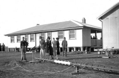
Black and white photograph, Local photograph. Original of this scan held by Nhill Historical Society, Aeradio Building c1937
... The building and its equipment were part of a comprehensive system of radio towers, signalling and meteorology equipment aimed at providing safer navigation for aircraft travelling throughout Australia. ...The building and its equipment were part of a comprehensive system of radio towers lights and signalling equipment aimed at providing safer navigation for aircraft travelling throughout Australia. ...The building and its equipment were part of a comprehensive system of radio towers, signalling and meteorology equipment aimed at providing safer navigation for aircraft travelling throughout Australia. ...This building is still intact at the Nhill Aerodrome. Some of the infrastructure is also in place or can be evidenced by its foundations.The Aeradio building was built on the present aerodrome in 1937. This was one of only sixteen buildings of this type built across Australia and it housed radio communications and guidance equipment. The building and its equipment were part of a comprehensive system of radio towers, signalling and meteorology equipment aimed at providing safer navigation for aircraft travelling throughout Australia. The facility closed in the 1960sThis photo is significant due to it having been taken soon after the building was constructed. It is the earliest known photograph taken on an open to the public day before the receiver aerials were erected.The Aeradio building was built on the present (2012) aerodrome in 1937 or 1938. This was one of only fifteen buildings of this type built across Australia and it housed radio communications and guidance equipment. The building and its equipment were part of a comprehensive system of radio towers lights and signalling equipment aimed at providing safer navigation for aircraft travelling throughout Australia. The facility closed in the 1960sphoto, aeradio, early, civil aviation, dca, dept of civil aviation -
 Orbost & District Historical Society
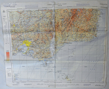
map, 1985
... Using these charts and other tools, pilots are able to determine their position, safe altitude, best route to a destination, navigation aids along the way, alternative landing areas in case of an in-flight emergency, and other useful information such as radio frequencies and airspace boundaries. ...Using these charts and other tools, pilots are able to determine their position, safe altitude, best route to a destination, navigation aids along the way, alternative landing areas in case of an in-flight emergency, and other useful information such as radio frequencies and airspace boundaries. ...An aeronautical chart is a map designed to assist in navigation of aircraft. Using these charts and other tools, pilots are able to determine their position, safe altitude, best route to a destination, navigation aids along the way, alternative landing areas in case of an in-flight emergency, and other useful information such as radio frequencies and airspace boundaries. World aeronautical charts have a scale of 1:1,000,000 and cover relatively large areas. Orbost Aero Club began in 1969 with Basil Dowie as Chair, David Nixon as Secretary/Treasurer. The group went into recess from 1977-1991 closing in 1997. The mid 1960s were boom years in flying training in Australia and the number of Aero Clubs grew rapidly. The Club played a significant role in the establishment of the small airport at Marlo and in the ongoing operation and development of the airport over the years particularly for patient transfer by aerial ambulance. The Orbost Aero Club Club played a significant role in the establishment of the small airport at Marlo and in the ongoing operation and development of the airport over the years.A laminated map of eastern Victoria. A World Aeronautical Chart. It shows elevations, longitude etc and is designed for pre-flight planning as well as pilotage. Top left hand corner - D.F.N.Nixon VH-FWD 12 Kristine Ct Cheletenham 27/7/87orbost-aero-club aeronautical-map