Showing 41 items matching "railway bridge greensborough"
-
 Greensborough Historical Society
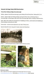
Document - Submission, Norm Colvin et al, Banyule Heritage Study 2020 Nominations - Plenty River railway bridge Greensborough, 2020
... Banyule Heritage Study 2020 Nominations - Plenty River railway bridge Greensborough. ...Part of the single track railway extension of 1902 from Heidelberg to Eltham, the Plenty River railway bridge Greensborough, was nominated for the Banyule Heritage Study 2020. ...Text and photographs Banyule Heritage Study 2020 Nominations - Plenty River railway bridge Greensborough. Document Submission Norm Colvin Anne Paul ...Part of the single track railway extension of 1902 from Heidelberg to Eltham, the Plenty River railway bridge Greensborough, was nominated for the Banyule Heritage Study 2020. This nomination was prepared by Norm Colvin & Anne Paul on behalf of the Greensborough Historical Society1 p. Text and photographshurstbridge rail line, plenty river, banyule heritage study 2020 -
 Greensborough Historical Society
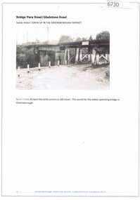
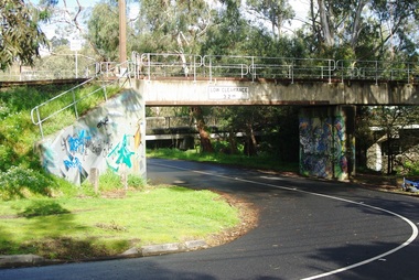
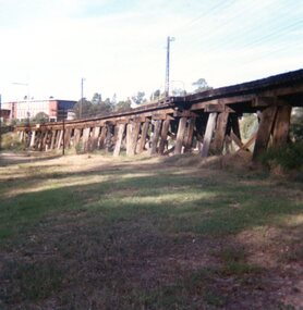
Article and Photograph, Bridge at Para Road and Gladstone Road, 2018_
... railway bridge greensborough...Information and photograph about the railway bridge at Para Road and Gladstone Road Greensborough....Any information is the opinion of the contributor. railway bridge greensborough gladstone road briar hill para road greensborough Article and photograph sourced from social media. ...Information and photograph about the railway bridge at Para Road and Gladstone Road Greensborough.This photograph and text was copied from a Facebook site. Members are people who lived in the Greensborough area and share their reminiscences of the area with others. The site is administered by a GHS member but is not officially affiliated with the Society. Any information is the opinion of the contributor. Article and photograph sourced from social media.railway bridge greensborough, gladstone road briar hill, para road greensborough -
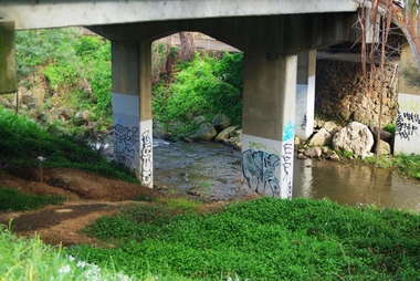
 Greensborough Historical Society
Photograph - Digital image, Marilyn Smith, Railway Road Rail Bridge over Plenty River Briar Hill, 17/09/2014
... Rail bridge over Railway Road Greensborough....Greensborough Historical Society 34A Glenauburn Road Lower Plenty Lower Plenty melbourne Rail bridge over Railway Road Greensborough. ...Rail bridge over Railway Road Greensborough.Digital copy of colour photograph -
 Greensborough Historical Society
Photograph - Digital image, Marilyn Smith, Railway Road Rail Bridge over Plenty River Briar Hill, 17/09/2014
... Rail bridge over Railway Road Greensborough....Greensborough Historical Society 34A Glenauburn Road Lower Plenty Lower Plenty melbourne Rail bridge over Railway Road Greensborough. railway road greensborough Digital copy of colour photograph Railway Road Rail Bridge over Plenty River Briar Hill Photograph - Digital image Marilyn Smith ...Rail bridge over Railway Road Greensborough.Digital copy of colour photographrailway road greensborough -
 Greensborough Historical Society
Photograph - Digital image, Marilyn Smith, Railway Road Rail Bridge over Plenty River Briar Hill, 17/09/2014
... Rail bridge over Railway Road Greensborough, near Para Road....Greensborough Historical Society 34A Glenauburn Road Lower Plenty Lower Plenty melbourne Rail bridge over Railway Road Greensborough, near Para Road. railway road greensborough para road greensborough Digital copy of colour photograph Railway Road Rail Bridge over Plenty River Briar Hill Photograph - Digital image Marilyn Smith ...Rail bridge over Railway Road Greensborough, near Para Road.Digital copy of colour photographrailway road greensborough, para road greensborough -
 Eltham District Historical Society Inc
Photograph, Trestle Bridge, Eltham, c.1910
... Most likely an F-Class 2-4-0 Steam Locomotive pushing carriage about to cross the Eltham Railway Trestle Bridge heading towards Greensborough, viewed from what was later Eltham Common and site of the re-located Shillinglaw Cottage (1964) and Eltham Library (1994). ...Eltham District Historical Society Inc 728 Main Rd Eltham melbourne Most likely an F-Class 2-4-0 Steam Locomotive pushing carriage about to cross the Eltham Railway Trestle Bridge heading towards Greensborough, viewed from what was later Eltham Common and site of the re-located Shillinglaw Cottage (1964) and Eltham Library (1994). ...Most likely an F-Class 2-4-0 Steam Locomotive pushing carriage about to cross the Eltham Railway Trestle Bridge heading towards Greensborough, viewed from what was later Eltham Common and site of the re-located Shillinglaw Cottage (1964) and Eltham Library (1994). On the far side of the track on what is present day Central Park oval is a crop field. The railway was commenced in 1900 and passed through the middle of the Shillinglaw Farm. Here it passes through the farm paddocks. The train station at Eltham opened in 1902. Colour photocopy of original photo print (on loan?) 25.5 x 39 cm mounted on coreflutePencil mark at bottom "(c) 1910"eltham, trestle bridge, bridges, shillinglaw farm, f-class 2-4-0 steam locomotive, eltham railway trestle bridge, eltham trestle bridge, railway bridge, steam locomotive -
 Eltham District Historical Society Inc
Document - Folder, Spence, Maxwell
... Greensborough RSL...Joe Poulter...Fairfield RSL Youth Club...Bristcoes Hardware Merchants...Montmorency RSL...Jack Shallard...Ted Weiland...Petrie Park...South Riding Ratepaers and Tenants Association...Dr Keith Alexander...Fred Durham...Eltham Shire Council...Meruka Park...Max Watson...Eric Harmer...Spence Park Montmorency...Mountain View Railway Bridge...Maxwell Spence Briar Hill Montmorency Fernside Avenue Briar Hill Montmorency State School Were Street Montmorency Briar Hill State School Stan Stainsby Hee Alcock Ned Haughton Australian Paper Mills Lovitool Tomasetti baker of Greensborough Gladstone Avenue Briar Hill Beaconsfield Road Briar Hill Williams Road Briar Hill Ellis family Hillcrest playfield field Ben Barnett Bill Slater Colin Pugh Clifton Pugh St Helena Karingal Drive St Helena Ted Walker Weidligh Roslind Miller Graham Kennedy Jimmy Beale Leach Street St Helena Plenty River St Faith's Chrch of England Briar Hil St Andrew's Church Briar Hill St Francis Xavier Catholic Church Briar Hill Herbie Wilson Victoria Coffee Palace Eltham Higher Elementary School Kate McKenie Diamond Creek Frank Phillips Wingrove Park Bremner's Park Orrs Dam Pecks Dam Wal Scriver Montmorency Tennis Club Albert Price Hill Fred Balaam Greensborough RSL Joe Poulter Fairfield RSL Youth Club Bristcoes Hardware Merchants Montmorency RSL Jack Shallard Ted Weiland Petrie Park South Riding Ratepaers and Tenants Association Dr Keith Alexander Fred Durham Eltham Shire Council Meruka Park Max Watson Eric Harmer Spence Park Montmorency Mountain View Railway Bridge Montmrency Pre School Lower Plenty Fire Brigade Eltham High School Newspaper clippings, A4 photocopies, etc Spence, Maxwell Document Folder ...Max Spence came to Briar Hill as a child in 1923, and lived in the area for many years. Contents Typed and manuscript notes (2pp missing from MS), undated but ?c1990. "Spence: My Briar Hill and Montmorency." Reminiscences of Maxwell Spence of Briar Hill and Montmorency from 1923. Manuscript notes, AGM 1991, "Max Spence". Newspaper clippings, A4 photocopies, etcmaxwell spence, briar hill, montmorency, fernside avenue briar hill, montmorency state school, were street montmorency, briar hill state school, stan stainsby, hee alcock, ned haughton, australian paper mills, lovitool, tomasetti baker of greensborough, gladstone avenue briar hill, beaconsfield road briar hill, williams road briar hill, ellis family, hillcrest playfield field, ben barnett, bill slater, colin pugh, clifton pugh, st helena, karingal drive st helena, ted walker, weidligh, roslind miller, graham kennedy, jimmy beale, leach street st helena, plenty river, st faith's chrch of england briar hil, st andrew's church briar hill, st francis xavier catholic church briar hill, herbie wilson, victoria coffee palace, eltham higher elementary school, kate mckenie, diamond creek, frank phillips, wingrove park, bremner's park, orrs dam, pecks dam, wal scriver, montmorency tennis club, albert price hill, fred balaam, greensborough rsl, joe poulter, fairfield rsl youth club, bristcoes hardware merchants, montmorency rsl, jack shallard, ted weiland, petrie park, south riding ratepaers and tenants association, dr keith alexander, fred durham, eltham shire council, meruka park, max watson, eric harmer, spence park montmorency, mountain view railway bridge, montmrency pre school, lower plenty fire brigade, eltham high school -
 Eltham District Historical Society Inc
Photograph, Tess Justine (Nillumbik Shire Council), Murray's Bridge over the Diamond Creek, Eltham North, 19 Feb 2022
... bridge over Diamond Creek from this period may have been located close to the northern boundary of the farm. John Langlands, owner of the farm known as ‘Ihurst’ on the west side of Diamond Creek to the south of the Murray’s land, died in 1907. In 1909 his land was then subdivided into 100 lots to become the ‘Glen Park Estate’. Other similar subdivisions of nineteenth century farms around Eltham in this period included the ‘Franktonia (or Beard’s) Estate’ to the northeast and ‘Bonsack’s Estate’ between Eltham and Greensborough. Soon after the opening of the railway...bridge over Diamond Creek from this period may have been located close to the northern boundary of the farm. John Langlands, owner of the farm known as ‘Ihurst’ on the west side of Diamond Creek to the south of the Murray’s land, died in 1907. In 1909 his land was then subdivided into 100 lots to become the ‘Glen Park Estate’. Other similar subdivisions of nineteenth century farms around Eltham in this period included the ‘Franktonia (or Beard’s) Estate’ to the northeast and ‘Bonsack’s Estate’ between Eltham and Greensborough. Soon after the opening of the railway ...Murray's Bridge over the Diamond Creek on the Diamond Creek Trail just prior to demolition and replacement with a new steel bridge. Heritage advice obtained by Nillumbik Shire Council, following a suggestion by the Eltham District Historical Society (EDHS), is that the original bridge appears to have been a simplified version of the Country Roads Board’s (CRB) standard timber bridge design of the early-to-mid 1920s. In c1990 Murray’s bridge was renovated with three recycled steel girders as part of a bike/pedestrian path in the reserve. During these alterations many parts of the bridge were removed, and some were replaced. Heritage advice indicates the condition of Murray’s bridge is poor. The remaining original parts are all in poor condition, with severe weathering, splitting and rot, especially to the stringers retained on the bridge. Heritage advice is that Murray’s Bridge does not have sufficient significance in the cultural history of the Nillumbik area to warrant inclusion in the Nillumbik Shire Heritage Overlay and also does not have sufficient significance as a rare survivor to warrant inclusion in the Nillumbik Shire Heritage Overlay. There are no indications in the historical record that this site was individually important to the cultural history of this area. EDHS is comfortable with the heritage advice provided to Council and has worked closely on this project with Council. EDHS has suggested some of the removed timbers be used in the vicinity of the bridge for landscaping and possibly seating, so as to retain these remnants close to the site of the original bridge, which is the last old timber bridge along the lower reaches of the Diamond Creek. Mary (Sweeney) Murray and John Wright Murray selected 80 acres, Lot C Section 16 and Lot 5 Section 17 Parish of Nillumbik, under an occupation license in 1866. John died in 1867 and freehold was granted to his son John in 1873. The farm was known as ‘Laurel Hill’. John Junior was an Eltham Shire councillor and sometime president from 1887 up until 1897. He added Lot A Section 16 to the farm in ca1888. John and his younger brother James arranged to rent/purchase Lot B Section 17, across Diamond Creek to the west, in ca1900. It appears that John and James farmed separately for a few years, with a new homestead built for James ad family on the high point of Lot B Section 17 in ca1910. John sold off Lot 5 Section 17 in 1912. When John died in 1912 James took over the land on both sides of the Diamond Creek. The old homestead on the west side of the Creek disappeared. A farm bridge over Diamond Creek from this period may have been located close to the northern boundary of the farm. John Langlands, owner of the farm known as ‘Ihurst’ on the west side of Diamond Creek to the south of the Murray’s land, died in 1907. In 1909 his land was then subdivided into 100 lots to become the ‘Glen Park Estate’. Other similar subdivisions of nineteenth century farms around Eltham in this period included the ‘Franktonia (or Beard’s) Estate’ to the northeast and ‘Bonsack’s Estate’ between Eltham and Greensborough. Soon after the opening of the railway extension line from Eltham to Hurstbridge in 1912, Glen Park and nearby residents including James Murray agitated for a railway station or siding to be located half-way between Eltham and Hurstbridge, so that the Glen Park residents who used the railway daily did not have to walk into the Eltham or Hurstbridge stations. Some believed Coleman’s Corner (opposite Edendale Farm) was an appropriate spot for the platform. James Murray was among those who thought the railway should be located on his land, closer to half-way between Eltham and Hurstbridge stations. The Railways Commissioners warned that the locals would have to fund these works themselves. The Glen Park Estate residents initially had difficulty accessing Eltham by road, with only an old low-level bridge over Diamond Creek at the south end of their estate. A new timber trestle bridge across the creek, now on Wattletree Road, was opened in 1915. Road access to the north was gained in 1927 when the new Murray’s Road, which crossed the Murray’s land, was built. Residents continued to agitate for a Glen Park station. By 1926 the Railways Commissioners’ preferred site was on the Murray’s land. They arranged an estimate of cost of a full-length platform. The estimate was too much for the locals, who in 1928 argued unsuccessfully for a shorter and hence cheaper platform. By 1929 Murray had agreed to donate the land, but the locals would still have to fund the works. Murray decided, unilaterally it would appear, to commence work on a timber trestle road bridge over Diamond Creek to link the new Murray Road to the proposed station. Late in 1929 he stopped work on the bridge, for reasons unknown, but started work again and completed the bridge in 1931. There is no further newspaper evidence of the campaign for the Glen Park station until 1939, when Murray and another local, Mr Maxwell, met the Railways Commissioner. The Glen Park locale now included 45 homes on the west side of the creek and 20 on the Eltham side. Most of the residents used the train every day. The Commissioner remained adamant that only a full-length platform could be built for safety reasons. It appears the campaign dissolved at this point. The increasing move to cars may have had an impact. There is no evidence of Murray’s bridge ever being connected to Murray’s Road, or of it having wide use for any purpose by locals. James Murray died in 1947 and the farm was taken over by his son James (Jim). Jim started to sell off parts of the farm in the 1980s, retaining a few acres around the ca1910 homestead and building a new house there. Recreation reserves were established along the creek. In ca1990 Murray’s bridge was renovated with steel girders as part of a bike/pedestrian path in the reserve. The old farmhouse was demolished in ca2014. * * * A theory posted on local community Facebook groups was that the bridge was built in the 1860s and was built to be more robust than was necessary for the movement of cows from one side of the creek to the other. It was suggested the robustness was necessary to support the weight of gold ore being transferred from a mine on Murray’s land to a railway siding near Murrays Bridge (presumably for transfer and processing at Diamond Creek). Perhaps this may have been one of the motivators for Murray, who really knows? Knowing when mining operations ceased on his land and how that fits the overall timeline would be useful but at the time the bridge was built, local gold production was minimal at best. The known facts are: • The railway line came to Eltham in 1902. • The extension of the railway from Eltham to Hurstbridge was constructed in 1912 so no railway line even existed through Murray's property until 1912 and the Victorian Railways maps at the time show no such siding on Murray’s property. • In 1923 a new company was formed in anticipation of the old Diamond Creek Gold Mine being re-opened. The mine had been previously closed and flooded. It was noted in the press at the time that the mine was within a mile of the railway. Nothing really came of this. • Construction of Murrays Bridge was commenced by James Murray in early 1929 in anticipation of a proposed flag station being nominated on his land, but work ceased shortly afterwards. The proposed flag station was commonly referred to as Glen Park as the residents of the Glen Park Estate wanted Option 1, located near them with the platform adjacent to Colemans corner. This was probably never going to fly as it was virtually in eyesight of Eltham station. Allandale Road was the third option, but the Commissioners' preferred option was No. 2 - on Murray's property. • The Railway Commissioners were not going to finance any such station and the works had to be funded by private landowners and residents, hence Murray investing in this himself. • Murray recommenced work two years later and finished his bridge in 1931 but unfortunately for him, the proposed flag station never eventuated. The bluestone siding you reference may well have been built by Murray as part of the proposed station platform. • Up until then, apart from the Main Road bridge, which was washed away in 1924, virtually all local crossings over the Diamond Creek were low lying bridges – Kaylocks Bridge at Brougham Street, Diamond Street bridge, Glen Park Road bridge. It is expected that Murray also had a low-lying bridge to connect his land either side of the creek. These were all washed away or severely damaged multiple times in the 1920s. Lessons were learnt, and Murrays Bridge appears to have been built in accordance with Country Road Board standards of the time. Flood damage was ongoing, and even more recently constructed raised bridges kept getting washed away, e.g., the new Wattle Tree Road bridge in 1958 just months after completion. Murray’s bridge was reinforced with steel some 30 years ago presumably to provide additional floodwater resistance, given the history of bridges disappearing in floodwaters. • In March 1932 it was reported in the Advertiser that there were still some prospectors operating around Eltham North who apart from further scarring the face of the earth over the previous two years had gained significant experience but little gold - hardly a driving factor for constructing a dedicated railway siding and bridge to transfer gold ore. It is far more probable that James Murray was hoping to have the railway station located on his property and invested his money by building the bridge to lead to it as well as a station platform. Had the station eventuated, it may well have driven up the value of his land for subdivision and new housing estates like the Glen Park Estate. That did not eventuate. Whilst the bridge was indeed old (90 years), the core structure being completed in 1931, it had been modified substantially from original and hence had no significant historic value – i.e., it was not a representative example of its type, construction, and age. Given that the bridge was not worthy of saving, the Eltham District Historical Society with Council’s support, and the Eltham Woodworkers group endeavoured to see what suitable sized timbers were salvageable to fabricate a commemorative seat. Unfortunately, the experts at the Woodworkers group were unable to salvage any suitable length/width timbers to fabricate the seat due to the presence of rot. Last remaining wooden trestle bridge on the Diamond Creek Trail just prior to demolition and replacementBorn digital image (27)diamond creek (creek), diamond creek trail, murrays bridge, ‘laurel hill’, john wright murray, mary (sweeney) murra, john murray jnr, james murray, john langlands, ‘ihurst’, ‘glen park estate’, beard's estate, franktonia, bonsack's estate, glen park estate, glen park railway station -
 Eltham District Historical Society Inc
Photograph, Tess Justine (Nillumbik Shire Council), Construction work on replacement of Murray's Bridge over the Diamond Creek, Eltham North, 31 Mar 2022
... bridge over Diamond Creek from this period may have been located close to the northern boundary of the farm. John Langlands, owner of the farm known as ‘Ihurst’ on the west side of Diamond Creek to the south of the Murray’s land, died in 1907. In 1909 his land was then subdivided into 100 lots to become the ‘Glen Park Estate’. Other similar subdivisions of nineteenth century farms around Eltham in this period included the ‘Franktonia (or Beard’s) Estate’ to the northeast and ‘Bonsack’s Estate’ between Eltham and Greensborough. Soon after the opening of the railway...bridge over Diamond Creek from this period may have been located close to the northern boundary of the farm. John Langlands, owner of the farm known as ‘Ihurst’ on the west side of Diamond Creek to the south of the Murray’s land, died in 1907. In 1909 his land was then subdivided into 100 lots to become the ‘Glen Park Estate’. Other similar subdivisions of nineteenth century farms around Eltham in this period included the ‘Franktonia (or Beard’s) Estate’ to the northeast and ‘Bonsack’s Estate’ between Eltham and Greensborough. Soon after the opening of the railway ...Construction work on replacement of Murray's Bridge over the Diamond Creek on the Diamond Creek Trail Mary (Sweeney) Murray and John Wright Murray selected 80 acres, Lot C Section 16 and Lot 5 Section 17 Parish of Nillumbik, under an occupation license in 1866. John died in 1867 and freehold was granted to his son John in 1873. The farm was known as ‘Laurel Hill’. John Junior was an Eltham Shire councillor and sometime president from 1887 up until 1897. He added Lot A Section 16 to the farm in ca1888. John and his younger brother James arranged to rent/purchase Lot B Section 17, across Diamond Creek to the west, in ca1900. It appears that John and James farmed separately for a few years, with a new homestead built for James ad family on the high point of Lot B Section 17 in ca1910. John sold off Lot 5 Section 17 in 1912. When John died in 1912 James took over the land on both sides of the Diamond Creek. The old homestead on the west side of the Creek disappeared. A farm bridge over Diamond Creek from this period may have been located close to the northern boundary of the farm. John Langlands, owner of the farm known as ‘Ihurst’ on the west side of Diamond Creek to the south of the Murray’s land, died in 1907. In 1909 his land was then subdivided into 100 lots to become the ‘Glen Park Estate’. Other similar subdivisions of nineteenth century farms around Eltham in this period included the ‘Franktonia (or Beard’s) Estate’ to the northeast and ‘Bonsack’s Estate’ between Eltham and Greensborough. Soon after the opening of the railway extension line from Eltham to Hurstbridge in 1912, Glen Park and nearby residents including James Murray agitated for a railway station or siding to be located half-way between Eltham and Hurstbridge, so that the Glen Park residents who used the railway daily did not have to walk into the Eltham or Hurstbridge stations. Some believed Coleman’s Corner (opposite Edendale Farm) was an appropriate spot for the platform. James Murray was among those who thought the railway should be located on his land, closer to half-way between Eltham and Hurstbridge stations. The Railways Commissioners warned that the locals would have to fund these works themselves. The Glen Park Estate residents initially had difficulty accessing Eltham by road, with only an old low-level bridge over Diamond Creek at the south end of their estate. A new timber trestle bridge across the creek, now on Wattletree Road, was opened in 1915. Road access to the north was gained in 1927 when the new Murray’s Road, which crossed the Murray’s land, was built. Residents continued to agitate for a Glen Park station. By 1926 the Railways Commissioners’ preferred site was on the Murray’s land. They arranged an estimate of cost of a full-length platform. The estimate was too much for the locals, who in 1928 argued unsuccessfully for a shorter and hence cheaper platform. By 1929 Murray had agreed to donate the land, but the locals would still have to fund the works. Murray decided, unilaterally it would appear, to commence work on a timber trestle road bridge over Diamond Creek to link the new Murray Road to the proposed station. Late in 1929 he stopped work on the bridge, for reasons unknown, but started work again and completed the bridge in 1931. There is no further newspaper evidence of the campaign for the Glen Park station until 1939, when Murray and another local, Mr Maxwell, met the Railways Commissioner. The Glen Park locale now included 45 homes on the west side of the creek and 20 on the Eltham side. Most of the residents used the train every day. The Commissioner remained adamant that only a full-length platform could be built for safety reasons. It appears the campaign dissolved at this point. The increasing move to cars may have had an impact. There is no evidence of Murray’s bridge ever being connected to Murray’s Road, or of it having wide use for any purpose by locals. James Murray died in 1947 and the farm was taken over by his son James (Jim). Jim started to sell off parts of the farm in the 1980s, retaining a few acres around the ca1910 homestead and building a new house there. Recreation reserves were established along the creek. In ca1990 Murray’s bridge was renovated with steel girders as part of a bike/pedestrian path in the reserve. The old farmhouse was demolished in ca2014. Born digital image (5)diamond creek (creek), diamond creek trail, murrays bridge, ‘laurel hill’, john wright murray, mary (sweeney) murra, john murray jnr, james murray, john langlands, ‘ihurst’, ‘glen park estate’, beard's estate, franktonia, bonsack's estate, glen park estate, glen park railway station -
 Eltham District Historical Society Inc
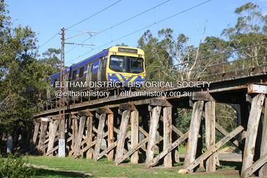
Photograph - Digital Photograph, Alan King, Eltham Railway Trestle Bridge, 28 December 2007
... railway bridge over creek and road has 34 timber-beam spans and four steel-joist spans, supported by four-pile timber piers and timber abutments. It has almost 200m of timber deck. All of the timbers have been replaced over the years, but the only change to the bridge’s character was the addition of pylons and wiring for electric trains in 1923. A petition for a railway to the shire was first made in 1883. A large deputation of local citizens to the Commissioner of Railways proposed a route passing through Alphington to midway between Greensborough...railway bridge over creek and road has 34 timber-beam spans and four steel-joist spans, supported by four-pile timber piers and timber abutments. It has almost 200m of timber deck. All of the timbers have been replaced over the years, but the only change to the bridge’s character was the addition of pylons and wiring for electric trains in 1923. A petition for a railway to the shire was first made in 1883. A large deputation of local citizens to the Commissioner of Railways proposed a route passing through Alphington to midway between Greensborough ...Covered under National Trust of Australia (Victoria) State Significance and Heritage Overlay, Nillumbik Planning Scheme. Published: Nillumbik Now and Then / Marguerite Marshall 2008; photographs Alan King with Marguerite Marshall.; p103 The Eltham railway trestle bridge is the only one of its kind still regularly used in Melbourne’s metropolitan railway network. Opened in 1902, it is also one of Victoria’s very few timber rail bridges that still carries trains.1 The bridge is part of the railway line extension from Heidelberg - extended to Hurstbridge in 1912. This extension resulted in one of the greatest social changes experienced in Eltham Shire, as it considerably lessened its isolation attracting tourists, artists and suburban commuters particularly after World War Two.2 The bridge has been classified by the National Trust as historically, scientifically, aesthetically and socially significant at state level. But this has not always been recognised, and in 1977, locals fought to save it from destruction. The Victorian Railways proposed to replace the bridge with an earth embankment and large culverts to avoid maintenance problems and fire. This was rejected by the Eltham Council who protested that the bridge helped maintain the area’s rural character, historic link and beauty, as well as avoiding possible serious flooding on the flood plain if a culvert was blocked. The bridge stands as part of a National Trust classified landscape which includes the Alistair Knox Park, named after the local conservationist and architect who helped to make Eltham famous for its mud-brick houses. The landscape includes tall and spreading manna gums and candlebarks, and the historic Shillinglaw Cottage. Artist Walter Withers, one of the Heidelberg School of painters, painted the bridge early in the 20th century. The 38 span single-track railway bridge over creek and road has 34 timber-beam spans and four steel-joist spans, supported by four-pile timber piers and timber abutments. It has almost 200m of timber deck. All of the timbers have been replaced over the years, but the only change to the bridge’s character was the addition of pylons and wiring for electric trains in 1923. A petition for a railway to the shire was first made in 1883. A large deputation of local citizens to the Commissioner of Railways proposed a route passing through Alphington to midway between Greensborough and Eltham up the Diamond Creek valley towards Queenstown and Kinglake. As a result the Princes Bridge-Heidelberg Railway was opened in 1888. From 1888 locals demanded a railway extension. Kangaroo Ground farmers in particular, led by Shire Councillor and Member for Evelyn, Ewen Cameron, said it would assist local farmers and orchardists send their produce to the Melbourne market. In 1890, before the severe economic Depression, an extension of the line to Hurst’s Bridge (now Hurstbridge) was included in a new Railways Bill. The parliamentary delegations were regaled with a banquet at Hurst’s barn and entertained by the Diamond Creek Brass Band, but the extension was abandoned when the Depression struck in 1892-1893. The extension of the railway to Eltham, completed in 1902, was one of the few built in those hard times. That is why the Eltham timber-trestle railway bridge is a rare example of a broad-gauge rail bridge constructed between 1893 and 1910. At the opening, despite persistent drizzle, 300 children waving flags and banners were among the large crowd welcoming the first train, carrying official dignitaries, to Eltham. It had taken 24 years to bring the railway to Eltham. From then Eltham became a popular destination for outings. Mr Orford of Eltham recalled that after the railway came to Eltham ‘the craze for picnics on weekends and holidays began…. During the wattle season, wattle trains came to Eltham frequently. The visitors roamed the creek pulling great armfuls of wattle blossom to take back with them to Melbourne’.3 In 1926 the railway line was electrified as part of the metropolitan rail network. But the Victorian Railways decided not to complete the formerly planned Diamond Valley Railway to Queenstown (now St Andrews) and Kinglake.This collection of almost 130 photos about places and people within the Shire of Nillumbik, an urban and rural municipality in Melbourne's north, contributes to an understanding of the history of the Shire. Published in 2008 immediately prior to the Black Saturday bushfires of February 7, 2009, it documents sites that were impacted, and in some cases destroyed by the fires. It includes photographs taken especially for the publication, creating a unique time capsule representing the Shire in the early 21st century. It remains the most recent comprehenesive publication devoted to the Shire's history connecting local residents to the past. nillumbik now and then (marshall-king) collection, eltham railway trestle bridge, eltham trestle bridge -
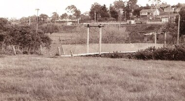
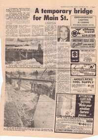 Greensborough Historical Society
Newspaper clipping, A temporary bridge for Main Street, 24/10/1978
... Leading up to the opening of Greensborough Plaza, traffic along Main Street was affected by the part closure due to the construction of a road bridge over the railway line....Greensborough Historical Society 34A Glenauburn Road Lower Plenty Lower Plenty melbourne Leading up to the opening of Greensborough Plaza, traffic along Main Street was affected by the part closure due to the construction of a road bridge over the railway line. ...Leading up to the opening of Greensborough Plaza, traffic along Main Street was affected by the part closure due to the construction of a road bridge over the railway line.Significant infrastructure changes in Greensborough at the time of the opening of Greensborough Plaza in 1978.Photocopy of news clipping (Item 958). Text and black and white images. -
 Greensborough Historical Society
Photograph - Digital image, Charles Marshall et al, Railway bridge at Tel-el-Fara, 1917_
... Greensborough Historical Society 34A Glenauburn Road Lower Plenty Lower Plenty melbourne This photograph shows a railway bridge in Tel-el-Fara, Palestine charles marshall world war 1 "Railway bridge over Waddi buzzetti [?] ...This photograph shows a railway bridge in Tel-el-Fara, PalestineDigital copy of black and white photograph. "Railway bridge over Waddi buzzetti [?] Tel-el Fara"charles marshall, world war 1 -
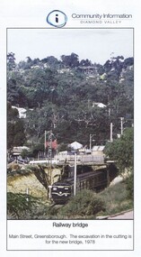 Greensborough Historical Society
Photograph - Digital Image, Greensborough Rail Bridge 1978, 1978_
... Greensborough rail bridge in 1978. The excavation in the cutting is for the new bridge. main street greensborough greensborough railway station Digital copy of one page of a newsletter Greensborough Rail Bridge 1978 Photograph - Digital Image ...A view of the Greensborough rail bridge in 1978. The excavation in the cutting is for the new bridge.Digital copy of one page of a newslettermain street greensborough, greensborough railway station -
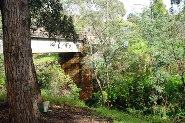
 Greensborough Historical Society
Photograph - Digital image, Jan Lewis, Flintoff Street swing bridge with Greensborough Railway Station in background circa 1958, 1958c
... Flintoff Street swing bridge with Greensborough Railway Station in background circa 1958...Greensborough Historical Society 34A Glenauburn Road Lower Plenty Lower Plenty melbourne Flintoff Street swing bridge and Greensborough station in background circa 1958 greensborough station flintoff street Digital copy of black and white photograph Flintoff Street swing bridge with Greensborough Railway Station in background circa 1958 Photograph - Digital image Jan Lewis ...Flintoff Street swing bridge and Greensborough station in background circa 1958Digital copy of black and white photographgreensborough station, flintoff street -
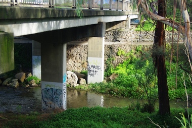 Greensborough Historical Society
Photograph - Digital image, Marilyn Smith, Railway Road Rail Bridge over Plenty River Briar Hill, 17/09/2014
... Greensborough Historical Society 34A Glenauburn Road Lower Plenty Lower Plenty melbourne Para Road bridge over Plenty River Greensborough, taken from the banks of the river. para road greensborough plenty river Digital copy of colour photograph Railway Road Rail Bridge over Plenty River Briar Hill Photograph - Digital image Marilyn Smith ...Para Road bridge over Plenty River Greensborough, taken from the banks of the river.Digital copy of colour photographpara road greensborough, plenty river -
 Greensborough Historical Society
Photograph - Digital image, Marilyn Smith, Railway Road Rail Bridge over Plenty River Briar Hill, 17/09/2014
... Greensborough Historical Society 34A Glenauburn Road Lower Plenty Lower Plenty melbourne Para Road bridge over Plenty River Greensborough, showing graffiti on bridge supports. para road greensborough plenty river Digital copy of colour photograph Railway Road Rail Bridge over Plenty River Briar Hill Photograph - Digital image Marilyn Smith ...Para Road bridge over Plenty River Greensborough, showing graffiti on bridge supports.Digital copy of colour photographpara road greensborough, plenty river -
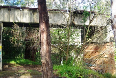 Greensborough Historical Society
Photograph - Digital image, Marilyn Smith, Railway Road Rail Bridge over Plenty River Briar Hill, 17/09/2014
... Greensborough Historical Society 34A Glenauburn Road Lower Plenty Lower Plenty melbourne Para Road bridge over Plenty River Greensborough, taken from the banks of the river. para road greensborough plenty river Digital copy of colour photograph Railway Road Rail Bridge over Plenty River Briar Hill Photograph - Digital image Marilyn Smith ...Para Road bridge over Plenty River Greensborough, taken from the banks of the river.Digital copy of colour photographpara road greensborough, plenty river -
 Greensborough Historical Society
Photograph - Digital image, Marilyn Smith, Railway Road Rail Bridge over Plenty River Briar Hill, 17/09/2014
... Greensborough Historical Society 34A Glenauburn Road Lower Plenty Lower Plenty melbourne Para Road near Railway Road Greensborough railway road greensborough para road greensborough Digital copy of colour photograph Railway Road Rail Bridge over Plenty River Briar Hill Photograph - Digital image Marilyn Smith ...Para Road near Railway Road Greensborough Digital copy of colour photographrailway road greensborough, para road greensborough -
 Greensborough Historical Society
Photograph, Trestle Bridge Eltham April 1979, 17/04/1979
... Greensborough Historical Society 34A Glenauburn Road Lower Plenty Lower Plenty melbourne A photograph of the railway trestle bridge at Eltham. ...A photograph of the railway trestle bridge at Eltham. Built in 1902, it is the only railway bridge of predominantly timber construction that is still in regular use. The bridge is listed on the Victorian Heritage Database.1 colour photograph.peter graham, eltham, trestle bridge eltham -
 Greensborough Historical Society
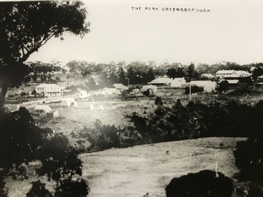
Photograph, The Park Greensborough, 1900c
... View of Greensborough Park from Partington's Hill, showing sporting ground, Plenty River, Marble Hall, sparse housing on north side of Main Road, the Farmers' Arms hotel, the Rechabite Hall and Main Road bridge over the the railway line. ...Greensborough Historical Society 34A Glenauburn Road Lower Plenty Lower Plenty melbourne View of Greensborough Park from Partington's Hill, showing sporting ground, Plenty River, Marble Hall, sparse housing on north side of Main Road, the Farmers' Arms hotel, the Rechabite Hall and Main Road bridge over the the railway line. ...View of Greensborough Park from Partington's Hill, showing sporting ground, Plenty River, Marble Hall, sparse housing on north side of Main Road, the Farmers' Arms hotel, the Rechabite Hall and Main Road bridge over the the railway line. Marble Hall is the double-storied building on the corner of Main Road.Part of a collection of 5 enlarged photographs dating from the early 1900s.Black and white enlargement of photographgreensborough park, main street greensborough, rechabite hall, farmers' arms hotel, marble hall, greensborough railway -
 Greensborough Historical Society
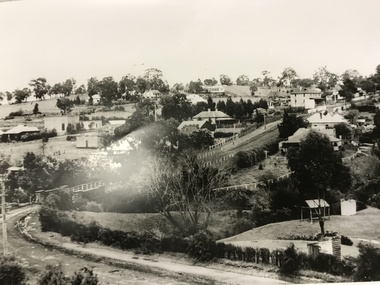
Photograph, Main Road bridge looking to township of Greensborough, 1929c
... bridge shows evidence of soot from steam trains and at the extreme left of picture the two concrete buildings indicate the line had been electrified. This occurred in 1923. Sparse housing is seen in the Flintoff Street and Grimshaw Street area. Part of a collection of photographic enlargements of views of Greensborough in the early 1900s. main street greensborough marble hall greensborough railway ...View of Main Street Greensborough from Partington's Hill including Plenty River bridge and Marble Hall on corner of Carter Street (now Para Road) and Main Street. This view of Greensborough Park shows the old pan toilets, the hawthorn fence line and the rather undeveloped roadside area of the park. Looking up Main Street we see the old Chapman house at the corner of Poulter Avenue and some newer houses below this. The stone river bridge appears to be only a single lane wide and the road approaching the bridge is unsealed. The rail bridge shows evidence of soot from steam trains and at the extreme left of picture the two concrete buildings indicate the line had been electrified. This occurred in 1923. Sparse housing is seen in the Flintoff Street and Grimshaw Street area.Part of a collection of photographic enlargements of views of Greensborough in the early 1900s.Black and white enlargement of photographic imagemain street greensborough, marble hall, greensborough railway, chapman house, greensborough park, poulter avenue greensborough, carter street, para road -
 Greensborough Historical Society
Photograph - Digital Image, Marilyn Smith, Mernda Station 2018, 27/09/2018
... Greensborough Historical Society 34A Glenauburn Road Lower Plenty Lower Plenty melbourne In 2018 GHS members visited Turner's Bakery in Mernda for lunch and continued on to visit historic sites remaining in the Mernda area. This photograph shows the newly built Mernda Station, part of the railway extension on the old Epping line. This station was opened in August 2018. Mernda is now the end of the line. It is sited on corner Bridge ...In 2018 GHS members visited Turner's Bakery in Mernda for lunch and continued on to visit historic sites remaining in the Mernda area. This photograph shows the newly built Mernda Station, part of the railway extension on the old Epping line. This station was opened in August 2018. Mernda is now the end of the line. It is sited on corner Bridge Inn Road and Schotters Road. Mernda is an area of rapid modern growth with a few remaining historic buildings dating from the 19th century.Digital copy of colour photographmernda, mernda historic sites, schotters road mernda, mernda station, bridge inn road mernda -
 Greensborough Historical Society
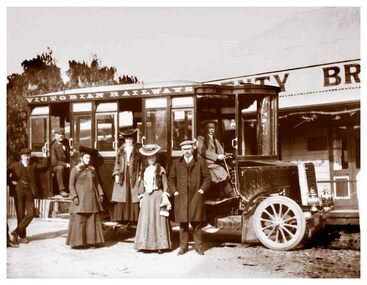
Photograph - Digital Image, Plenty Bridge Hotel Lower Plenty c1910, 1910s
... Greensborough Historical Society 34A Glenauburn Road Lower Plenty Lower Plenty melbourne Plenty Bridge Hotel Lower Plenty, 1910s. This photograph shows a group of travellers with a Victorian Railways bus outside the Plenty Bridge Hotel circa 1910. ...Plenty Bridge Hotel Lower Plenty, 1910s. This photograph shows a group of travellers with a Victorian Railways bus outside the Plenty Bridge Hotel circa 1910. A day trip to the countryside was a popular pastime for city dwellers.Digital copy of black and white photographlower plenty, plenty bridge hotel, lower plenty hotel, victorian railways -
 Eltham District Historical Society Inc
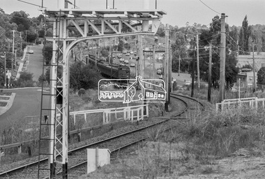
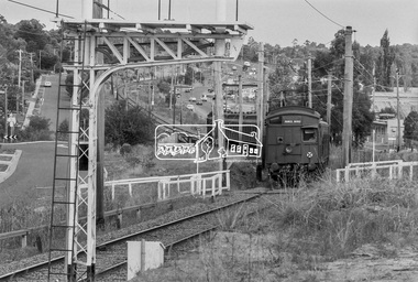
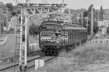
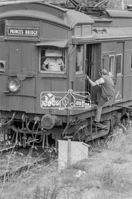
Photograph, George Coop, Princes Bridge bound Tait (Red Rattler) train approaching Greensborough Station, March 1980, 1980
... Railway Parade on left. Briar Hill industrial area on right. Greensborough Railway Station, industry, Para Road, Railway Parade, Red Rattler, Sherbourne Road, Tait Train Digital TIFF file Scan of 35mm Kodak Safety 5063 black and white transparency Princes Bridge bound Tait (Red Rattler) train approaching Greensborough Station, March 1980 Photograph George Coop ...Looking southeast along Para Road. Sherbourne road overpass in distance. Railway Parade on left. Briar Hill industrial area on right.Digital TIFF file Scan of 35mm Kodak Safety 5063 black and white transparencygreensborough railway station, industry, para road, railway parade, red rattler, sherbourne road, tait train -
 Eltham District Historical Society Inc
Photograph, George Coop, Princes Bridge bound Tait (Red Rattler) train approaching Greensborough Station, March 1980, 1980
... Railway Parade on left. Briar Hill industrial area on right. greensborough railway station, industry, para road, railway parade, red rattler, sherbourne road, tait train Digital TIFF file Scan of 35mm Kodak Safety 5063 black and white transparency Princes Bridge bound Tait (Red Rattler) train approaching Greensborough Station, March 1980 Photograph George Coop ...Looking southeast along Para Road. Sherbourne road overpass in distance. Railway Parade on left. Briar Hill industrial area on right.Digital TIFF file Scan of 35mm Kodak Safety 5063 black and white transparencygreensborough railway station, industry, para road, railway parade, red rattler, sherbourne road, tait train -
 Eltham District Historical Society Inc
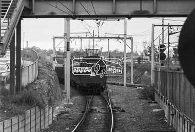
Photograph, George Coop, A Tait (Red Rattler) train departs Greensborough Railway Station bound for Princes Bridge, c. October 1982, 1982
... A Tait (Red Rattler) train departs Greensborough Railway Station bound for Princes Bridge, c. October 1982...Eltham District Historical Society Inc 728 Main Rd Eltham melbourne Greensborough Railway Station, Hurstbridge Line, Red Rattler, Tait Train Digital TIFF file Scan of 35mm Ilford FP4 black and white transparency A Tait (Red Rattler) train departs Greensborough Railway Station bound for Princes Bridge, c. ...Digital TIFF file Scan of 35mm Ilford FP4 black and white transparencygreensborough railway station, hurstbridge line, red rattler, tait train -
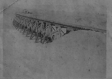
 Eltham District Historical Society Inc
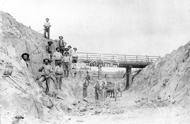
Negative - Photograph, Construction of Railway Line, Greensborough to Eltham, 1901
... It is significant in being the first community sourced collection representing the places and people of the Shire's first one hundred years. shire of eltham pioneers photograph collection eltham railway workers 1901 butty gang overpass railway construction railway line construction silver street bridge Digital image 120 format B&W negative Construction of Railway Line, Greensborough to Eltham Negative Photograph ...The Silver Street Bridge, 1901 Butty Gang workers excavate a rock cutting near the Silver Street bridge prior to laying of track. The Butty Gang system versus the Contract System was subject to public debate regarding cost benefits at the time of the Eltham line construction. Butty gang workers were a group of men who take a contract for a part of a work, as in the construction of railroads, etc., the proceeds being equally divided between them, with something extra to the foreman. Some hold picks, a couple of horses and carts are lined up probably for carting the broken rock away, dirt, rocks and shale lay at the bottom. A pair of small wooden buckets are evident, most likley to provide drinking water. The timber Silver Street bridge crosses the cutting in the background. The opening of the railway line from Heidelberg to Eltham took place on the 6th June 1902. Similiar to 810. Source: Mrs. Dandy, Montmorency and Miss McColl, 8 Anderson St., HeidelbergThis photo forms part of a collection of photographs gathered by the Shire of Eltham for their centenary project book,"Pioneers and Painters: 100 years of the Shire of Eltham" by Alan Marshall (1971). The collection of over 500 images is held in partnership between Eltham District Historical Society and Yarra Plenty Regional Library (Eltham Library) and is now formally known as the 'The Shire of Eltham Pioneers Photograph Collection.' It is significant in being the first community sourced collection representing the places and people of the Shire's first one hundred years.Digital image 120 format B&W negativeshire of eltham pioneers photograph collection, eltham, railway workers, 1901, butty gang, overpass, railway construction, railway line construction, silver street bridge -
 Eltham District Historical Society Inc
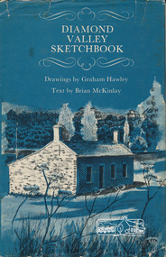
Book, Diamond Valley sketchbook / text by Brian McKinlay ; drawings by Graham Hawley, 1973
... Including The Griffin House, Rosehill, Lower Plenty, The Austin Hospital, Heidelberg, St John's Church, Heidelberg, Banyule, Heidelberg, Trestle Bridge, Eltham, Diamond Valley railway, The Shillinglaw Cottage, Eltham, Montsalvat, Old England Hotel, Heidelberg, Eltham Primary School, Mud brick homes, Eltham, Sweeney's Cottage, Eltham, Pound Pend Tunnel, The Gold Memorial, Potter's Cottage, Memorial Tower, Charterisville, Weller's Pub, The Barrel, Eltham, Hassall's Gallery, The Old Bridge, Greensborough, Diamond Valley Shire Offices, Greensborough, St Katherine's Chapel, Yan Yean Reservoir, Mernda Hotel, Mernda Mechanics Institute, Old Barn, Mernda, Parade College, La Trobe University....Including The Griffin House, Rosehill, Lower Plenty, The Austin Hospital, Heidelberg, St John's Church, Heidelberg, Banyule, Heidelberg, Trestle Bridge, Eltham, Diamond Valley railway, The Shillinglaw Cottage, Eltham, Montsalvat, Old England Hotel, Heidelberg, Eltham Primary School, Mud brick homes, Eltham, Sweeney's Cottage, Eltham, Pound Pend Tunnel, The Gold Memorial, Potter's Cottage, Memorial Tower, Charterisville, Weller's Pub, The Barrel, Eltham, Hassall's Gallery, The Old Bridge, Greensborough, Diamond Valley Shire Offices, Greensborough, St Katherine's Chapel, Yan Yean Reservoir, Mernda Hotel, Mernda Mechanics Institute, Old Barn, Mernda, Parade College, La Trobe University. diamond valley shire shire of nillumbik city of whittlesea city of Banyule Shillinglaw Cottage Weller's Hotel Hardback with jacket ; 63 p. : ill., maps ; 22cm. ...Contents include short articles and illustrations of historic properties within the municipalities of Banyule, Nillumbik and Whittlesea. Including The Griffin House, Rosehill, Lower Plenty, The Austin Hospital, Heidelberg, St John's Church, Heidelberg, Banyule, Heidelberg, Trestle Bridge, Eltham, Diamond Valley railway, The Shillinglaw Cottage, Eltham, Montsalvat, Old England Hotel, Heidelberg, Eltham Primary School, Mud brick homes, Eltham, Sweeney's Cottage, Eltham, Pound Pend Tunnel, The Gold Memorial, Potter's Cottage, Memorial Tower, Charterisville, Weller's Pub, The Barrel, Eltham, Hassall's Gallery, The Old Bridge, Greensborough, Diamond Valley Shire Offices, Greensborough, St Katherine's Chapel, Yan Yean Reservoir, Mernda Hotel, Mernda Mechanics Institute, Old Barn, Mernda, Parade College, La Trobe University.Hardback with jacket ; 63 p. : ill., maps ; 22cm. diamond valley shire, shire of nillumbik, city of whittlesea, city of banyule, shillinglaw cottage, weller's hotel