Showing 8931 items matching "range road"
-
 Mt Dandenong & District Historical Society Inc.
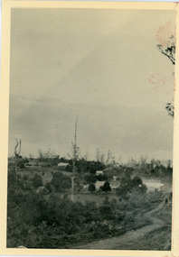
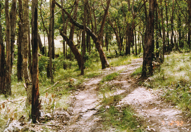
Photograph, View From Range Road, Olinda. 1909, 1909
... View From Range Road, Olinda. 1909......Range Road...1909 view of Olinda showing 'Charlemont' guest house and the Olinda school on the skyline above Dodd's stables. Range Road (The Bullock Track) is in the foireground. ...1909 view of Olinda from Range Road (The Bullock Track). Showing school on skyline above Dodd’s stables with “Charlemont” on left....Farndons Community Hall 42 Falls Road Mt Dandenong yarra-valley-and-the-dandenong-ranges Charlemont Guest House Dodd Dodd's stables stables olinda Olinda School Range Road Bullock Track 1909 view of Olinda from Range Road (The Bullock Track). ...1909 view of Olinda showing 'Charlemont' guest house and the Olinda school on the skyline above Dodd's stables. Range Road (The Bullock Track) is in the foireground. The descriptive text on the reverse of this photograph was hand written by John Lundy-Clarke.1909 view of Olinda from Range Road (The Bullock Track). Showing school on skyline above Dodd’s stables with “Charlemont” on left.charlemont guest house, dodd, dodd's stables, stables, olinda, olinda school, range road, bullock track -
 Bendigo Historical Society Inc.
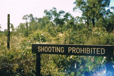
Photograph - PETER ELLIS COLLECTION: RIFLE RANGE ROAD
... PETER ELLIS COLLECTION: RIFLE RANGE ROAD...Colour photograph. Rifle Range Road. Shooting Prohibited....History House 11 Mackenzie Street Bendigo goldfields PHOTOGRAPH Landscape No Shooting Colour photograph. Rifle Range Road. Shooting Prohibited. Photograph PETER ELLIS COLLECTION: RIFLE RANGE ROAD ...Colour photograph. Rifle Range Road. Shooting Prohibited.photograph, landscape, no shooting -
 Eltham District Historical Society Inc
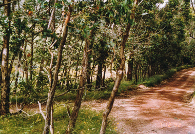
Photograph, Track to Rifle Range Road off Fox Road, Smiths Gully, 7 December 1992, 07/12/1992
... Track to Rifle Range Road off Fox Road, Smiths Gully, 7 December 1992......rifle range road...Eltham District Historical Society Inc 728 Main Rd Eltham melbourne The Eltham Horse Trail: Research and Warrandyte to Kinglake: Survey of proposed route, December 1992: (3) Kangaroo Ground to Kinglake eltham horse trail (1992 survey) smiths gully fox road rifle range road Two colour photographs Track to Rifle Range Road off Fox Road, Smiths Gully, 7 December 1992 Photograph ...The Eltham Horse Trail: Research and Warrandyte to Kinglake: Survey of proposed route, December 1992: (3) Kangaroo Ground to KinglakeTwo colour photographseltham horse trail (1992 survey), smiths gully, fox road, rifle range road -
 Eltham District Historical Society Inc
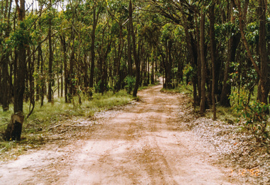
Photograph, Rifle Range Road, Smiths Gully, 7 December 1992, 07/12/1992
... Rifle Range Road, Smiths Gully, 7 December 1992......rifle range road...Eltham District Historical Society Inc 728 Main Rd Eltham melbourne The Eltham Horse Trail: Research and Warrandyte to Kinglake: Survey of proposed route, December 1992: (3) Kangaroo Ground to Kinglake eltham horse trail (1992 survey) smiths gully rifle range road Colour photograph Rifle Range Road, Smiths Gully, 7 December 1992 Photograph ...The Eltham Horse Trail: Research and Warrandyte to Kinglake: Survey of proposed route, December 1992: (3) Kangaroo Ground to KinglakeColour photographeltham horse trail (1992 survey), smiths gully, rifle range road -
 Eltham District Historical Society Inc
Photograph, Rifle Range Road Track near Buttermans Track, St Andrews, 7 December 1992, 07/12/1992
... Rifle Range Road Track near Buttermans Track, St Andrews, 7 December 1992......rifle range road track...Eltham District Historical Society Inc 728 Main Rd Eltham melbourne The Eltham Horse Trail: Research and Warrandyte to Kinglake: Survey of proposed route, December 1992: (3) Kangaroo Ground to Kinglake eltham horse trail (1992 survey) buttermans track rifle range road track st andrews Colour photograph Rifle Range Road Track near Buttermans Track, St Andrews, 7 December 1992 Photograph ...The Eltham Horse Trail: Research and Warrandyte to Kinglake: Survey of proposed route, December 1992: (3) Kangaroo Ground to KinglakeColour photographeltham horse trail (1992 survey), buttermans track, rifle range road track, st andrews -
 Mt Dandenong & District Historical Society Inc.
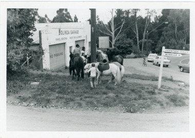
Photograph, Pony Club Outside Olinda Garage 1960s, c1960
... ...Range Road...Olinda garage on corner of Range Road and Mt Dandenong Tourist Road. Pony Club with 4 horses on grass. ralph Jones was garage owner at this time. ...Farndons Community Hall 42 Falls Road Mt Dandenong yarra-valley-and-the-dandenong-ranges Pony Club Olinda Garage garage Olinda Range Road mt dandenong tourist road Ralph Jones Olinda garage on corner of Range Road and Mt Dandenong Tourist Road. ...Olinda garage on corner of Range Road and Mt Dandenong Tourist Road. Pony Club with 4 horses on grass. ralph Jones was garage owner at this time. Dragster bike on road indicates early 1960s.pony club, olinda garage, garage, olinda, range road, mt dandenong tourist road, ralph jones -
 Ringwood and District Historical Society
Photograph, Ringwood Rifle Range, Jumping Creek Road, South Warrandyte, 1959
... Ringwood Rifle Range, Jumping Creek Road, South Warrandyte, 1959....Black and white photogaph (3 copies) Ringwood Rifle Range, Jumping Creek Road, South Warrandyte, 1959. Photograph ...Black and white photogaph (3 copies)Written on back of photographs, "Ringwood Rifle Range, Jumping Creek, South Warrandyte, 1959". -
 Mt Dandenong & District Historical Society Inc.
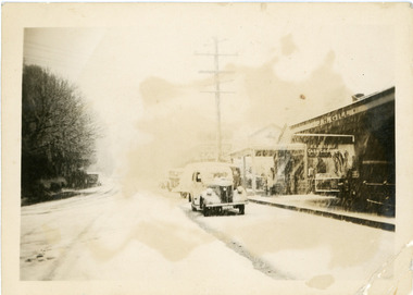
Photograph, Main Street Olinda c1950, c1950
... During heavy snowfall looking down Main Street Olinda towards Range Road. Old car parked outside J.H. Gill's store. c1950...Farndons Community Hall 42 Falls Road Mt Dandenong yarra-valley-and-the-dandenong-ranges snow Olinda car Main Street J.H.Gill During heavy snowfall looking down Main Street Olinda towards Range Road. ...During heavy snowfall looking down Main Street Olinda towards Range Road. Old car parked outside J.H. Gill's store. c1950snow, olinda, car, main street, j.h.gill -
 Mt Dandenong & District Historical Society Inc.
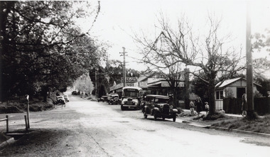
Photograph, Olinda Township c1950, c1950
... Scene in Olinda township looking up towards range Road. Cars and busses parked along roadside and women and children on footpath. ...Farndons Community Hall 42 Falls Road Mt Dandenong yarra-valley-and-the-dandenong-ranges Olinda Gills Newsagency Scene in Olinda township looking up towards range Road. ...Scene in Olinda township looking up towards range Road. Cars and busses parked along roadside and women and children on footpath. General Store and Gills Newsagency on LHS. c1950.olinda, gills newsagency -
 Mt Dandenong & District Historical Society Inc.
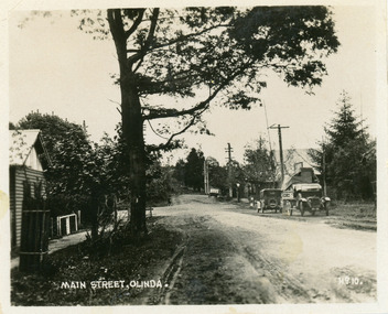
Photograph, Main Street, Olinda, c1930s
... View is looking NW from Olinda Monbulk Road towards Range Road. Left hand building is old Olinda Post Office. ...View is looking NW from Olinda Monbulk Road towards Range Road. Left hand building is old Olinda Post Office. ...Number 10 in commercial seriesSmall photograph, number 10 in Olinda series, showing Main Street Olinda. View is looking NW from Olinda Monbulk Road towards Range Road. Left hand building is old Olinda Post Office. Ice truck is outside shops in distance and a delivery truck with tarp can be seen. c1930solinda, post office, truck -
 Ringwood and District Historical Society
Photograph, Maroondah Highway West, Ringwood. The "Rest" tea rooms, Maroondah Highway, opposite Heatherdale Road (now demolished) (undated)
... Label attached to photograph reads, "Old house on north side of Maroondah Highway near Range View Road. Built during 1800s - now demolished". ...Ringwood and District Historical Society 125A Warrandyte Road Ringwood North melbourne Label attached to photograph reads, "Old house on north side of Maroondah Highway near Range View Road. ...Black and white photograph (2 images)Label attached to photograph reads, "Old house on north side of Maroondah Highway near Range View Road. Built during 1800s - now demolished". -
 Mt Dandenong & District Historical Society Inc.
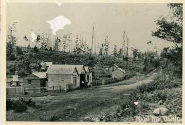
Photograph, Main Street Olinda c1908
... Coonara Road, then Mernda Road leads up out the picture right, Mt Dandenong Road goes down left. Range Road (the bullock track) is in immediate foreground and Sassafras turns to the right before the visible tracks on Mernda Road....Coonara Road, then Mernda Road leads up out the picture right, Mt Dandenong Road goes down left. Range Road (the bullock track) is in immediate foreground and Sassafras turns to the right before the visible tracks on Mernda Road. c1908 view of Main Street Olinda with Dodd's store in foreground and Olinda State School up on the hill. ...c1908 view of Main Street Olinda with Dodd's store in foreground and Olinda State School up on the hill. Reverse of photograph has handwritten description by John Lundy-Clarke.Photo of Olinda taken about 1908 showing State School on skyline. Dodd’s store in foreground. Hodges blacksmith shop on roadside right. Coonara Road, then Mernda Road leads up out the picture right, Mt Dandenong Road goes down left. Range Road (the bullock track) is in immediate foreground and Sassafras turns to the right before the visible tracks on Mernda Road.olinda, jack dodd, general store, school -
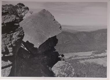 Halls Gap & Grampians Historical Society
Photograph - B/W, C 1960s
... The Fyans Valley is below with the Mt. William range behind it. Roads traverse the valley. Some buildings can be seen....The Fyans Valley is below with the Mt. William range behind it. Roads traverse the valley. Some buildings can be seen. ...Slab of rock is known as the The Fallen GiantPhoto shows large slab of rock with other rock outcrops. The Fyans Valley is below with the Mt. William range behind it. Roads traverse the valley. Some buildings can be seen.scenery, wonderland range -
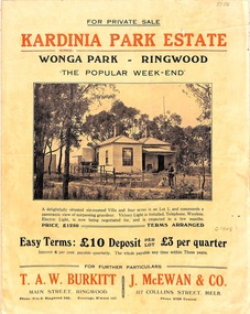 Ringwood and District Historical Society
Flyer, Land Sale Brochure, Kardinia Park Estate, North Ringwood, Vic. - circa 1948
... Front page features photograph of a man and dog in front of a house captioned as Lot 1 on four acres shown on the estate layout as cnr of Brysons Road and Range View Parade (later Omeo Parade). ...Subdivision includes Kardinia Crescent, Wonga Road, Brysons Road, Range View Parade (later Omeo Parade), Motor Coach Road (later Wonga Park Road, then Warranwood Road). ...Ringwood and District Historical Society 125A Warrandyte Road Ringwood North melbourne Subdivision includes Kardinia Crescent, Wonga Road, Brysons Road, Range View Parade (later Omeo Parade), Motor Coach Road (later Wonga Park Road, then Warranwood Road). ...Folded buff-coloured land sale advertisement for Kardinia Park Estate in Warranwood area of North Ringwood, including terms of sale, area map, layout plan of the estate, and summary of local facilities and services. Front page features photograph of a man and dog in front of a house captioned as Lot 1 on four acres shown on the estate layout as cnr of Brysons Road and Range View Parade (later Omeo Parade). Second page includes bushland swimming pool photograph and promotional information for prospective buyers.Subdivision includes Kardinia Crescent, Wonga Road, Brysons Road, Range View Parade (later Omeo Parade), Motor Coach Road (later Wonga Park Road, then Warranwood Road). (Agent/s) T.A.W. Burkitt, Main Street, Ringwood, Phone (9 to 6) Ringwood 242, Evenings, Ringwood 157, and J. McEwan & Co, 317 Collins Street, Melbourne, Phone 6750 Central. -
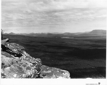 Halls Gap & Grampians Historical Society
Photograph - B/W
... View over a large Valley with ranges in the distance. Roads through the valley are visible and a body of water in the middle right of the photograph. ...When reproducing please acknowledge Forests Commission Victoria Negative no. 322-26 View over a large Valley with ranges in the distance. Roads through the valley are visible and a body of water in the middle right of the photograph. ...Photo is of Moora Moora in the Victorian Valley. Typical of the time as a promotional image taken by Forests Commission Victoria.View over a large Valley with ranges in the distance. Roads through the valley are visible and a body of water in the middle right of the photograph. A rocky outcrop is in the left side foreground.Publicity & Public Relations Branch. When reproducing please acknowledge Forests Commission Victoria Negative no. 322-26scenery, grampians ranges -
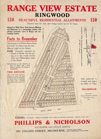 Ringwood and District Historical Society
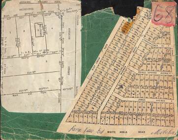
Flyer, Land Sale Advertisement and auction notice - Range View Estate, Ringwood, Victoria - 1920
... Subdivision includes Deep Creek Road, Range View Grove, Warnes Road, Tarrangower Avenue, Prince Edward Avenue, James Avenue, and White Horse Road, Mitcham. ...Ringwood and District Historical Society 125A Warrandyte Road Ringwood North melbourne Subdivision includes Deep Creek Road, Range View Grove, Warnes Road, Tarrangower Avenue, Prince Edward Avenue, James Avenue, and White Horse Road, Mitcham. ...Advertisement for sale of 150 residential allotments with terms of sale, summary of local features and services, and map showing location and layout of subdivision within the boundary of Mitcham to the west of Ringwood, Victoria. Copy of newspaper advertisement (The Herald, Melbourne, Wednesday 3 March, 1920) refers to public auction date for Range View Estate Ringwood - Saturday, 27th March, 1920.Subdivision includes Deep Creek Road, Range View Grove, Warnes Road, Tarrangower Avenue, Prince Edward Avenue, James Avenue, and White Horse Road, Mitcham. Agents - Phillips & Nicholson, 281 Collins Street, Melbourne, Telephone Central 10907. -
 Ringwood and District Historical Society
Card, Collage of Residential Subdivision Map Clippings - Ashleigh Poultry Farm, Blackburn, Vic and Range View East, Mitcham, Vic. (Undated, circa 1930s)
... Ashleigh Poultry Farm - Layout of weatherboard house and six residential allotments on Whitehorse Road and Ashleigh Street (later Ashburn Place), Blackburn, Victoria. 2. 140 allotments with frontages on Deep Creek Road, Warnes Road, Range View Grove, Tarrangower Avenue, Prince Edward Avenue, James Avenue and White Horse Road, Mitcham, Victoria....Ashleigh Poultry Farm - Layout of weatherboard house and six residential allotments on Whitehorse Road and Ashleigh Street (later Ashburn Place), Blackburn, Victoria. 2. 140 allotments with frontages on Deep Creek Road, Warnes Road, Range View Grove, Tarrangower Avenue, Prince Edward Avenue, James Avenue and White Horse Road, Mitcham, Victoria. ...Weekly Times (Melbourne, Vic.) Sat 24 Aug 1935 Page 6 - 1800 Chickens Burnt. Starting in the incubator room, a fire at the Ashleigh Poultry Farm, Whitehorse Road Blackburn, early on August 20, incinerated 1800 young chickens and 1000 eggs. The incubator room and the chicken pens were reduced to ashes, but a large drum of kerosene standing in the room was undamaged! The owners of the farm, Mrs N. Foote and her sons, have suffered a severe setback, as practically all their chickens and eggs are gone, and it is too late to start hatching again this season.Two maps mounted on green cardboard. 1. Ashleigh Poultry Farm - Layout of weatherboard house and six residential allotments on Whitehorse Road and Ashleigh Street (later Ashburn Place), Blackburn, Victoria. 2. 140 allotments with frontages on Deep Creek Road, Warnes Road, Range View Grove, Tarrangower Avenue, Prince Edward Avenue, James Avenue and White Horse Road, Mitcham, Victoria. -
 Bendigo Historical Society Inc.
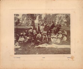
Photograph - GROUP PORTRAIT - PICNICKING IN BUSH
... Appears to have Big Hill range in background, road with white posts running across background. ...Appears to have Big Hill range in background, road with white posts running across background. ...Black and white image mounted on cream board : image shows large group of men, women and children, sitting, standing and reclining on grass. Eucalyptus trees in background, horse grazing. Man at rear of group is seated on a horse. Man behind horse's head is pouring a bottle into a glass. Circa late 1800's ? Potentially picnic is at Ravenswood. Appears to have Big Hill range in background, road with white posts running across background. On bottom of image on board ' W.H. Robinson, photo, Bendigo'W.H. Robinson, Bendigocottage, miners, bendigo, picnic, family, ravenswood. photographer w. h. robinson, bendigo. -
 Ringwood and District Historical Society
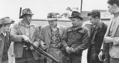
Photograph, Ringwood Rifle Club. 'Mail' photo, 13/5/1954
... Written on back of second copy- "Ringwood Rifle Club met at corner Main St. and Warrandyte Rd. to proceed to range Jumping Creek Road, South Warrandyte. Const. W. ...Road Ringwood North melbourne Written on back of one copy- "Ringwood Rifle Club. 'Mail' photo, 13/5/1954. L. to R. Vic Beveridge, Constable Bill Hall team captain, Frank Corr, Frank Phillips, Jim Walker and J. Wood". Written on back of second copy- "Ringwood Rifle Club met at corner Main St. and Warrandyte Rd. to proceed to range ...Black and white photograph (2 copies)Written on back of one copy- "Ringwood Rifle Club. 'Mail' photo, 13/5/1954. L. to R. Vic Beveridge, Constable Bill Hall team captain, Frank Corr, Frank Phillips, Jim Walker and J. Wood". Written on back of second copy- "Ringwood Rifle Club met at corner Main St. and Warrandyte Rd. to proceed to range Jumping Creek Road, South Warrandyte. Const. W. Hall, Capt. 2nd from left." -
 Bendigo Historical Society Inc.
Letter - Michele Matthews Collection: PHD Research - Relief during the great depression, 22 Nov 1932
... The schedule of works includes a range of road construction and improvement projects. ...The schedule of works includes a range of road construction and improvement projects. ...Dr Michele Matthews has been a local and social historian for nearly three decades since she first used correspondence held by the then Bendigo City Council for her Honours thesis. She is an ardent advocate for the use of local history records to tell Victorian and Australian history from a grassroots perspective. Michele’s MA thesis, ‘A forgotten “Father” of Federation: Sir John Quick 1852‑1911’ (2003), and her PhD thesis, ‘Survivors, schemes, Samaritans and shareholders: the impact of the Great Depression on Bendigo and District 1925‑1935’ (2007), both drew heavily on Bendigo and district records. Michele Matthews Collection: PHD Research - Relief during the great depression This item includes the following documents: 8672.43a The document is a letter dated 22 November 1932 from the Town Clerk to the Secretary of the Public Works Department in Melbourne. It confirms that the Council accepts the conditions of the Victorian Government's Christmas Relief Work Scheme, under which £1,500 had been allocated to the municipality to provide employment for registered unemployed people before Christmas. The Council explains that it will supplement the government grant with an additional £574 of its own funds. The proposed program is intended to employ approximately 200 workers, including labourers, painters, carpenters and concreters, on projects that are described as being of a permanent nature and outside the normal municipal works program. The letter emphasises that these projects will provide meaningful employment while also improving local infrastructure. The schedule of works includes a range of road construction and improvement projects. These include extending Hargreaves Street into Panton Street with a flood crossing and pipe culvert, constructing Murphy Street and repairing a large culvert, cutting down Comet Hill on Holmes Road to improve traffic visibility, constructing Hodgkinson Street, widening the intersection of Howard, Reginald and Harkness Streets, and removing stone outcrops and cutting back the embankment on Mackenzie Street. In addition to road works, the proposal includes municipal maintenance projects such as demolishing the old lock-up and sheds, screening material for top dressing and trimming paths in Rosalind Park, removing grass and vegetation from residential roads, and cleaning and repainting the exterior woodwork of the Town Hall. These works combined infrastructure improvements with general civic maintenance, allowing a wide variety of unemployed workers to be engaged. The accompanying budget allocates separate amounts for materials and labour for each project. The total expenditure is £500 for materials and £1,574 for labour, matching the Council's contribution and demonstrating that the majority of funding would be directed towards wages to maximise employment opportunities. The letter concludes with the Town Clerk's formal endorsement of the proposal.bendigo, michele matthews collection, letters seeking support in bendigo during the great depression 1932 to 1934 -
 Falls Creek Historical Society
Clothing - Shirt Falls Creek Mountain Bike Park Crew
... The high-altitude trails of Falls Creek include a range of wide gravel roads to winding single trails. The graded trails include rides to the Rocky Valley Lake, historic cattlemen’s huts such as Cope Hut and Wallaces Hut, the top of Mt McKay, Pretty Valley Lake and for the experts the ride to Mt Nelse and the Spion Kopje summit. ...The high-altitude trails of Falls Creek include a range of wide gravel roads to winding single trails. The graded trails include rides to the Rocky Valley Lake, historic cattlemen’s huts such as Cope Hut and Wallaces Hut, the top of Mt McKay, Pretty Valley Lake and for the experts the ride to Mt Nelse and the Spion Kopje summit. ...The Falls Creek Mountain Bike Park opened in 2013 with 40 kilometres of trails in the Victorian Alpine National Park. Designed and built by World Trail, the bike trails provide access to beautiful alpine terrain. The rides now extend over more than 50 kilometres, catering for a range of abilities and providing activities in the summer season. All trails start and finish in the resort. The high-altitude trails of Falls Creek include a range of wide gravel roads to winding single trails. The graded trails include rides to the Rocky Valley Lake, historic cattlemen’s huts such as Cope Hut and Wallaces Hut, the top of Mt McKay, Pretty Valley Lake and for the experts the ride to Mt Nelse and the Spion Kopje summit. MTB Bike Patrol Top To ensure rider safety, Falls Creek Resort introduced a Bike Patrol service during shuttle operating hours. Many Ski Patrol members transitioned into these roles, offering riders peace of mind that medical care was available quickly if needed. The program highlighted the resort's commitment to duty of care and to growing mountain biking responsibly. This shirt was designed by Australian Company Dharco as a highly visible uniform for crew at the Falls Creek Mountain Bike Park. Jo Prothero, Director of Marketing for Falls Creek Resort Management from 2012 to 2019, generously donated two mountain bike jerseys that capture a pivotal era in the resort's history. During Jo's tenure, the resort made significant investments in mountain bike trails, aiming to activate the village during the summer months and support local businesses. This development included appointing Blue Dirt as the resort's first shuttle operator, transporting riders from Howman's Gap to the Summit.This shirt is significant as it is representative of the Falls Creek Mountain Bike Park development.A uni-sex style shirt designed to be worn by mountain bike crews in Falls Creek, Victoria. It has multi-coloured panels of black, orange, yellow and grey. It features an image of a mountain biker descending a slope on the front along with the manufacturer's name. Sponsors' logos also feature across the lower backOn front: PARK CREW/ DHARCO On back: Falls Creek Mountain Bike Park On both sleeves: PARK CREWfalls creek mountain bike park, falls creek staff uniform -
 Warrnambool and District Historical Society Inc.
Folder, Warrnambool Theatre Chorale documents, Late 20th century
... Warrnambool and District Historical Society Inc. 2 Gilles Street (south of Merri St) Warrnambool great-ocean-road This collection of papers relating to the Warrnambool Theatre Group chorale contains AGM minutes,office bearers, publicity and Warrnambool Standard information as well as membership lists. Some of the programs relate to performances which were done by the Warrnambool Theatre company of which this group was an off shoot. The dates range ...This collection of papers relating to the Warrnambool Theatre Group chorale contains AGM minutes,office bearers, publicity and Warrnambool Standard information as well as membership lists. Some of the programs relate to performances which were done by the Warrnambool Theatre company of which this group was an off shoot. The dates range from the 1989 to 2012.This collection of papers connected to the Warrnambool Theatre Group Chorale shows a number of connections between local groups some musical others are community groups. Grey folder with items relating to the Warrnambool theatre chorale from 1989 to 2012. The entries include concert programs, advertising material and financial statements. -
 Warrnambool and District Historical Society Inc.
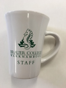
Mug, Brauer College, Early 21st century
... Road. At the start of 1990 the school was renamed Brauer School, with the name taken from a prominent 20th century doctor in the town, Dr Alfred Brauer. Today the school is a secondary school offering a comprehensive range...Road. At the start of 1990 the school was renamed Brauer School, with the name taken from a prominent 20th century doctor in the town, Dr Alfred Brauer. Today the school is a secondary school offering a comprehensive range ...This is a souvenir mug from Brauer College, Warrnambool. It is intended to be used by staff members from the school. Brauer College is in Caramut Road, Warrnambool and began as the Warrnambool Technical School which was established in Timor Street in 1913. The first Principal of the School, John King, served for 29 years. Additional buildings were constructed at the site over the ensuing years. In 1965 Warrnambool North Technical School was established at Albert Park (now merged with Warrnambool High School to become today’s Warrnambool College). In 1973 Warrnambool Technical School moved from the Timor Street site and re-located to Caramut Road. At the start of 1990 the school was renamed Brauer School, with the name taken from a prominent 20th century doctor in the town, Dr Alfred Brauer. Today the school is a secondary school offering a comprehensive range of subjects. This item is of minor interest of an inexpensive souvenir of Brauer College WarrnamboolThis is a souvenir china mug from Brauer College, Warrnambool. It is white with a green Brauer College sea horse emblem and the words ‘Brauer College, Warrnambool Staff’. The words ‘Brauer College’ are underlined. ‘Brauer College Warrnambool Staff’ ‘Made in China’ dr a. brauer, brauer college, history of warrnambool -
 Warrnambool and District Historical Society Inc.
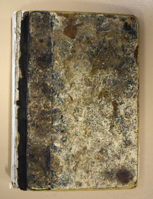
Book, Book Certificate of Titles A-Z Index, C 1890
... Warrnambool and District Historical Society Inc. 2 Gilles Street (south of Merri St) Warrnambool great-ocean-road This book contains certificates of title and Crown grants which record local changes of ownership.many are in the township of Warrnambool while others relate to areas such as Nullawarre, Purnim and Framlingham.These documents come under the Transfer of lands act of 1890. This book has many local names and properties and is an historic link for the district. warrnambool certificate of titles warrnambool 1900 The dates range ...This book contains certificates of title and Crown grants which record local changes of ownership.many are in the township of Warrnambool while others relate to areas such as Nullawarre, Purnim and Framlingham.These documents come under the Transfer of lands act of 1890.This book has many local names and properties and is an historic link for the district.Brown heavy card cover with red fabric binding. It has an alphabetical index at the front followed by 200 pages of certificates of title.Descriptions of the land is written at the top of the pages with drawn and coloured diagrams below. The dates range from C 1878 to to C 1966. Some are certificate of title and others are Crown Grant. warrnambool, certificate of titles warrnambool 1900 -
 Warrnambool and District Historical Society Inc.
Administrative record - Warrnambool Waterworks Newspaper Cuttings, 1891 to 1917
... road This ledger contains newspaper cuttings form The Warrnambool Standard newspaper from May 1891 to October 1917. The cuttings are reports of meetings of the Warrnambool Waterworks Trust. In the early days of Warrnambool domestic water and water for fire suppression was supplied by tanks, wells and springs. In the 1870s various schemes were proposed to find a better supply of water. In 1891 the Warrnambool Waterworks Trust was formed using water from the Merri River. This system lasted until 1939 when the Warrnambool water supply came from the Otway ranges ...This ledger contains newspaper cuttings form The Warrnambool Standard newspaper from May 1891 to October 1917. The cuttings are reports of meetings of the Warrnambool Waterworks Trust. In the early days of Warrnambool domestic water and water for fire suppression was supplied by tanks, wells and springs. In the 1870s various schemes were proposed to find a better supply of water. In 1891 the Warrnambool Waterworks Trust was formed using water from the Merri River. This system lasted until 1939 when the Warrnambool water supply came from the Otway ranges. This system is still the water supply for Warrnambool today. The cuttings in this ledger will be useful for research.This is a ledger with a brown mottled cover and a leather spine and leather corners. The spine is partly detached. The front cover has a label pasted on it. The pages originally had hand written entries (The Minutes of a Warrnambool organisation). Newspaper cuttings have been pasted over the original writing. Warrnambool Waterworks Trust Newspaper Reports From 19th May 1891 To --- warrnambool waterworks trust, warrnambool water supply -
 Warrnambool and District Historical Society Inc.
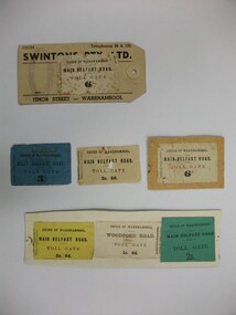
Document - Tickets, Toll road, 1866-1869
... Six are for the Main Belfast Road and one for the Woodford road. There are various prices ranging from sixpence to three shillings. ...Six are for the Main Belfast Road and one for the Woodford road. There are various prices ranging from sixpence to three shillings. ...In 1866, in an effort to maintain the main roads of the region it was decided to establish toll roads on the Belfast, Woodford Purnim and Allansford roads. Gates were erected and the leases were disposed of by auction. In 1867 the Woodford tollhouse was destroyed by fire suspected to be deliberate. The tolls were removed three years later after much opposition. These tickets are a physical link to one of the earliest attempts to introduce a toll road in the district. Seven toll road tickets five mounted on card. Light paper. Six are for the Main Belfast Road and one for the Woodford road. There are various prices ranging from sixpence to three shillings. Four are cream in colour, one each of blue, yellow and green. They are accompanied by a small newspaper cutting which relates the discovery of one such ticket and the situation of the Belfast tollhouses which were later relocated to 94 and 96 Henna Street near the Alderdice brass foundry.Shire of Warrnambool, Fairfax & Laurie Printers. tollgate, tollgate tickets, woodford toll tickets, shire of warrnambool -
 Warrnambool and District Historical Society Inc.
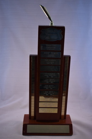
Artefact, Apex trophy South West District, C 1990
... road This trophy, donated by Camperdown Apex Club, was awarded to members of the South Western District for Dinner Notice Excellence. The winners listed on the trophy are Gerard Ryan, Camperdown, Desi Pekin, Cobden, Dale Alexander, Camperdown, Tim Fitzpatrick, Terang, Leigh Parker, Terang, John Berger, Terang, Kevin Dwyer, Koroit, Maree Fenton, Terang, Grant Picone, Terang and Darren Williamson, Colac. The dates range ...This trophy, donated by Camperdown Apex Club, was awarded to members of the South Western District for Dinner Notice Excellence. The winners listed on the trophy are Gerard Ryan, Camperdown, Desi Pekin, Cobden, Dale Alexander, Camperdown, Tim Fitzpatrick, Terang, Leigh Parker, Terang, John Berger, Terang, Kevin Dwyer, Koroit, Maree Fenton, Terang, Grant Picone, Terang and Darren Williamson, Colac. The dates range from 1991 to 2002. Apex Clubs are service clubs that provide people with the opportunity to volunteer within their community. Members are aged between 18 and 45. The first Apex Club was formed in Geelong in 1931 and Warrnambool Apex Club was the fifth club formed in 1931. It went into recess in 1941 and was re-established in 1952. The club closed in 2011. This trophy is retained as it comes from the Apex Clubs of the South West District and Warrnambool Apex Club, now closed, was a member of this group. This is a wooden trophy consisting of a wooden base with a wooden plinth with two wooden columns on either side. The columns have a gold-coloured strip running along the entire length of the columns. On top of the plinth is a gold-coloured holder for a pennant or flag. The base and the plinth have gold-coloured metal name plates. All of these contain inscribed names except one. Donated by Camperdown Apex Club South Western District Dinner Notice Excellence warrnambool apex club, history of warrnambool -
 Warrnambool and District Historical Society Inc.
Numismatics, Warrnambool Table Tennis Association, Mid 20th century
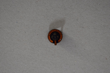
... Warrnambool and District Historical Society Inc. 2 Gilles Street (south of Merri St) Warrnambool great-ocean-road The Warrnambool Table Tennis Association is based in Cramer Street Warrnambool with eight courts and caters for a wide range of competition and social games. ...The Warrnambool Table Tennis Association is based in Cramer Street Warrnambool with eight courts and caters for a wide range of competition and social games.This badge has social and sporting links to the Warrnambool area.Round badge with small raised section at the top. It is enamelled in orange and royal blue. There is text around the edge and symbols in the centre area. Pin on the back.Warrnambool with stylised TTV in the centre section.warrnambool, warrnambool table tennis, badges -
 Warrnambool and District Historical Society Inc.
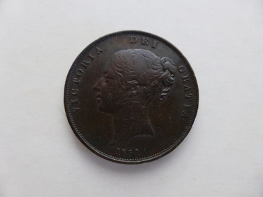
Coin, English Penny Victoria Det Gratia 1854, 1854
... Warrnambool and District Historical Society Inc. 2 Gilles Street (south of Merri St) Warrnambool great-ocean-road English currency before decimalisation in the 1970's consisted of pounds, shillings and pence with twelve pennies to the shilling and twenty shillings to the pound.Coins ranged from farthings which were one quarter of a penny through to pennies, threepence, sixpence, shillings ,half crowns and crowns. ...English currency before decimalisation in the 1970's consisted of pounds, shillings and pence with twelve pennies to the shilling and twenty shillings to the pound.Coins ranged from farthings which were one quarter of a penny through to pennies, threepence, sixpence, shillings ,half crowns and crowns. Most coins had a variety of common names such as a " bob" for a shilling a "quid for a pound and a tanner for a sixpence. This coin is the equivalent of five shillings and is known as a crown. The text around the obverse, "Victoria Dei Gratia 1844". On the reverse the text of Reg Fid Def"Britanniar translates as Queen of Britain and defender of the faith. This coin is one of the smaller denominations.A common currency coin which has social and historical significance.Round copper coin with flat edge. The The obverse has an image of the young Victoria with text around the edge.The reverse has an image of Brittania in a chariot.Dotted edge around the inside rim of both sides.BRITTANNIAR REG FID DEFon the reverse and Victoria Dei gratia on the obverse.english penny, 1854 penny -
Warrnambool and District Historical Society Inc.
Numismatics, Coin :English Crown 1844, 1844
... Warrnambool and District Historical Society Inc. 2 Gilles Street (south of Merri St) Warrnambool great-ocean-road English currency before decimalisation in the 1970's consisted of pounds, shillings and pence with twelve pennies to the shilling and twenty shillings to the pound.Coins ranged from farthings which were one quarter of a penny through to pennies, threepence, sixpence, shillings ,half crowns and crowns. ...English currency before decimalisation in the 1970's consisted of pounds, shillings and pence with twelve pennies to the shilling and twenty shillings to the pound.Coins ranged from farthings which were one quarter of a penny through to pennies, threepence, sixpence, shillings ,half crowns and crowns. Most coins had a variety of common names such as a " bob" for a shilling a "quid for a pound and a tanner for a sixpence. This coin is the equivalent of five shillings and is known as a crown. The text around the obverse, "Victoria Dei Gratia 1844". On the reverse the text of Regina Fid Def"Britanniarum translates as Queen of Britain and defender of the faith.The text around the edge, DECUS ET TUTAMEN ANNO REGNI VIII translates as " an ornament and a safeguard. Coins were thus stamped in an effort to reduce the incidence of penny pinching whereby small amounts of precious metal were shaved from the edge of coins and still passed as full value coins.This coin was minted in the eighth year of the reign of one of England's longest ruling monarchs.It is of historical and social significance with the study of coins having considerable interest for many people. Large silver coin with image of Queen Victoria on the obverse or heads side of the coin and a coat of arms with crown at the top surrounded by a wreath of leaves is on the reverse. Text is around the edge of both sides with text also stamped into the edge of the coin as well. Obverse " Victoria Dei Gratia 1844." Reverse "Regina Fid Def"Britanniarum"On edge of coin is "DECUS ET TUTAMEN ANNO REGNI VIII english coins, coin half crown, english coin crown, warrnambool