Showing 890 items matching "real estate agents -- kew (vic.)"
-
 Kew Historical Society Inc
Map - Map of Kew and Hawthorn Districts
... ...Real estate Agents -- Kew (Vic.)...Kew Historical Society Inc Kew Court House 188 High Street Kew melbourne Map of Kew, East Kew and Hawthorn produced for a Kew Real Estate Agent, RW Perry. The map is undated. maps - kew (vic) maps - hawthorn (vic) R.W. ...Map of Kew, East Kew and Hawthorn produced for a Kew Real Estate Agent, RW Perry. The map is undated.Two-colour map of Kew and Hawthorn Districts produced for by R.L. Jarrett for RW Perry, Real Estate & Insurance Agent. The map has unusual features such as a planned railway link from Kew Station to the former Outer Circle Railway. RW Perry / Real Estate & Insurance Agent, 602 High Street, East Kewmaps - kew (vic), maps - hawthorn (vic), r.w. perry, real estate agents -- kew (vic.) -
 Kew Historical Society Inc
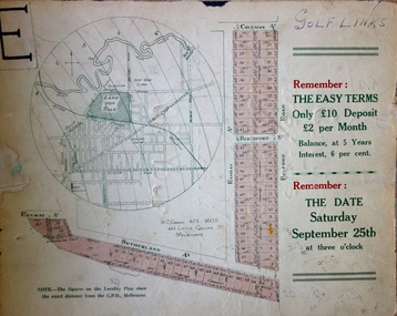
Plan - Subdivision Plan, H C Crouch, Old Golf Links Estate, 1930s
... real estate and financial agents. The numerous subdivision plans in the Kew Historical Society's collection represent working documents, ranging from the initial sketches made in planning a subdivision to printed plans on which auctioneers or agents listed the prices for which individual lots were sold. In a number of cases, the reverse of a subdivision plan in the collection includes a photograph of a house that was also for sale by the agent. These photographs provide significant heritage information relating house design and decoration, fencing and household gardens. Subdivisions -- Kew (Vic ...The land in North Kew between the Outer Circle Railway and the River Yarra was released in sections. This release included 80 lots. Most of this area was released during the Depression years in the early 1930s.Subdivision plans are historically important documents used as evidence of the growth of suburbs in Australia. They frequently provide information about when the land was sold on which a built structure was subsequently constructed as well as evidence relating to surveyors and real estate and financial agents. The numerous subdivision plans in the Kew Historical Society's collection represent working documents, ranging from the initial sketches made in planning a subdivision to printed plans on which auctioneers or agents listed the prices for which individual lots were sold. In a number of cases, the reverse of a subdivision plan in the collection includes a photograph of a house that was also for sale by the agent. These photographs provide significant heritage information relating house design and decoration, fencing and household gardens.One part of a massive subdivision of the Old Golf Links Estate in North Kew of 80 allotments bordering Sutherland Avenue, Ramsay Avenue, Belford Road, Beresford Street and Coleman Avenue. Inset on the plan at the top left, the route of the Outer Circle Railway is clearly marked. The Kew Golf Links is identified in its current location. The land on which Greenacres Golf Club was to be constructed is at this time marked as ‘Recreation Ground’. The ‘new bridge’ over the Yarra at Burke Road is also marked on the inset map. The Plan identifies the surveyor (sic) H.C. Crouch BCE MVIS, 443 Little Collins St., Melbourne. The date of the subdivision auction sale in identified as Saturday September 25th at three o'clock.Annotations: "E" top left. "Golf Links" top right. Lots 73-76 ticked and listed as "6" poundssubdivisions -- kew (vic.), old golf links estate -
 Kew Historical Society Inc
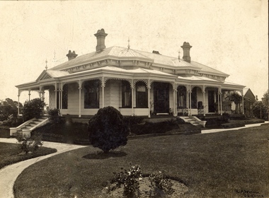
Photograph - 29 Uvadale Grove, Kew, 1920
... agent. Subdivision plans are historically important documents used as evidence of the growth of suburbs in Australia. They frequently provide information about when the land was sold on which a built structure was subsequently constructed as well as evidence relating to surveyors and real estate and financial agents. These photographs provide significant heritage information relating house design and decoration, fencing and household gardens. subdivisions - kew (vic ...The numerous subdivision plans in the Kew Historical Society's collection represent working documents, ranging from the initial sketches made in planning a subdivision to printed plans on which auctioneers or agents listed the prices for which individual lots were sold. In a number of cases, the reverse of a subdivision plan in the collection includes a photograph of a house that was also for sale by the agent. Subdivision plans are historically important documents used as evidence of the growth of suburbs in Australia. They frequently provide information about when the land was sold on which a built structure was subsequently constructed as well as evidence relating to surveyors and real estate and financial agents. These photographs provide significant heritage information relating house design and decoration, fencing and household gardens.When 29 Uvadale Grove, Kew was offered for sale it was described as: ‘Kew. Fine locality, 3 minutes Cotham Road. Splendidly built 6 roomed Brick Villa. Rooms 17 x 14, 16 x 13, &c. Beautifully fitted throughout. Land 70 x 134 to ROW.’ The price was advertised as being £1,400. The house exhibits key features of Federation architecture such as the gabled roof with a facing of half-timber and stucco. The veranda has a curved corrugated iron roof supported by timber pillars and fretwork. The slate roof with terra cotta ridging and finials marks a transition to the more common use of Marseilles tiles in Federation architecture.subdivisions - kew (vic.), 29 uvadale grove - kew (vic.) -
 Kew Historical Society Inc
Photograph - Victorian Villa, High Street, c.1922
... real estate and financial agents. The numerous subdivision plans in the Kew Historical Society's collection represent working documents, ranging from the initial sketches made in planning a subdivision to printed plans on which auctioneers or agents listed the prices for which individual lots were sold. In a number of cases, the reverse of a subdivision plan in the collection includes a photograph of a house that was also for sale by the agent. These photographs provide significant heritage information relating house design and decoration, fencing and household gardens. houses - maxton - high street - kew (vic ...Subdivision plans are historically important documents used as evidence of the growth of suburbs in Australia. They frequently provide information about when the land was sold on which a built structure was subsequently constructed as well as evidence relating to surveyors and real estate and financial agents. The numerous subdivision plans in the Kew Historical Society's collection represent working documents, ranging from the initial sketches made in planning a subdivision to printed plans on which auctioneers or agents listed the prices for which individual lots were sold. In a number of cases, the reverse of a subdivision plan in the collection includes a photograph of a house that was also for sale by the agent. These photographs provide significant heritage information relating house design and decoration, fencing and household gardens.An old inscription on this photograph identifies it as ‘an elegant timber villa in High Street. It occupied part of Lot 91, bought by Edward Glyn in the land sale of 16th October 1851, and run as a flower farm’. The subdivision called the ‘Flower Farm Estate’ in East Kew occurred in 1922. [The subdivision plan is on the reverse of this photo.] The Estate included 61 lots on either side of Boorool Road between High Street and Harp Road. In the MMBW Detail Plan 2017 of 1926, a number of these new villas had already been built. Matching houses with MMBW maps can always be a challenge, however if this house was near the corner of Boorool Road and High Street, it seems to fit the profile of a house called ‘Maxton’ (demolished).Photographer's name on photograph, lower right, and stamp on mount lower right: "A. Aberline, Glenferrie".houses - maxton - high street - kew (vic.), violet farm estate, subdivisions - kew (vic.) -
![Monnington [Estate], 1935](/media/collectors/550653872162f11fb04854aa/items/5907eb86d0ce0c14e82385c8/item-media/5907ecafd0ce0c14e823e87f/item-fit-380x285.jpg?cb=6) Kew Historical Society Inc
Kew Historical Society IncPlan - Subdivision Plan, Monnington [Estate], 1935, 1935
... real estate and financial agents. The numerous subdivision plans in the Kew Historical Society's collection represent working documents, ranging from the initial sketches made in planning a subdivision to printed plans on which auctioneers or agents listed the prices for which individual lots were sold. In a number of cases, the reverse of a subdivision plan in the collection includes a photograph of a house that was also for sale by the agent. These photographs provide significant heritage information relating house design and decoration, fencing and household gardens. Monnington - Adeney Avenue -- Kew (Vic ...Pru Sanderson, in her groundbreaking ‘City of Kew Urban Conservation Study : Volume 2 - Development History’ (1988), summarised the periods of urban development and subdivisions of land in Kew. The periods that she identified included 1845-1880, 1880-1893, 1893-1921, 1921-1933, 1933-1943, and Post-War Development. These periods were selected as they represented periods of rapid growth or decline in urban development. An obvious starting point for Sanderson’s groupings involved population growth and the associated economic cycles. These cycles also highlighted urban expansion onto land that was predominantly rural, although in other cases it represented the decline and breakup of large estates. A number of the plans in the Kew Historical Society’s collection can also be found in other collections, such as those of the State Library of Victoria and the Boroondara Library Service. A number are however unique to the collection.Subdivision plans are historically important documents used as evidence of the growth of suburbs in Australia. They frequently provide information about when the land was sold on which a built structure was subsequently constructed as well as evidence relating to surveyors and real estate and financial agents. The numerous subdivision plans in the Kew Historical Society's collection represent working documents, ranging from the initial sketches made in planning a subdivision to printed plans on which auctioneers or agents listed the prices for which individual lots were sold. In a number of cases, the reverse of a subdivision plan in the collection includes a photograph of a house that was also for sale by the agent. These photographs provide significant heritage information relating house design and decoration, fencing and household gardens.The first subdivision of Monnington took place in 1935. At that time, Monnington and 10 new allotments were offered for sale bordering Adeney and Marshall Avenues. In this subdivision plan, Monnington is one of 13 lots for sale. The subdivision created the irregular land holding of Monnington today. The excision of southwest corner of Monninton was caused by the need to have regular allotments facing the curve in Marshall Avenue.monnington - adeney avenue -- kew (vic.), subdivision plans -- kew (vic.) -
 Kew Historical Society Inc
Plan, Sydney Arnold Best & Co, Field Place, Kew, c.1929
... real estate firm - J. R. Mathers and McMillan, 136 Cotham Road, Kew. The Plans in the collection are rarely in pristine form, being working plans on which the agent would write notes and record lots sold and the prices of these. The subdivision plans are historically significant examples of the growth of urban Melbourne from the beginning of the 20th Century up until the 1980s. A number of the plans are double-sided and often include a photograph on the reverse. A number of the latter are by noted photographers such as J.E. Barnes. subdivision plans - kew field place subdivision -- studley park – kew (vic ...Pru Sanderson, in her groundbreaking ‘City of Kew Urban Conservation Study : Volume 2 - Development History’ (1988), summarised the periods of urban development and subdivisions of land in Kew. The periods that she identified included 1845-1880, 1880-1893, 1893-1921, 1921-1933, 1933-1943, and Post-War Development. These periods were selected as they represented periods of rapid growth or decline in urban development. An obvious starting point for Sanderson’s groupings involved population growth and the associated economic cycles. These cycles also highlighted urban expansion onto land that was predominantly rural, although in other cases it represented the decline and breakup of large estates. A number of the plans in the Kew Historical Society’s collection can also be found in other collections, such as those of the State Library of Victoria and the Boroondara Library Service. A number are however unique to the collection.The Kew Historical Society collection includes almost 100 subdivision plans pertaining to suburbs of the City of Melbourne. Most of these are of Kew, Kew East or Studley Park, although a smaller number are plans of Camberwell, Deepdene, Balwyn and Hawthorn. It is believed that the majority of the plans were gifted to the Society by persons connected with the real estate firm - J. R. Mathers and McMillan, 136 Cotham Road, Kew. The Plans in the collection are rarely in pristine form, being working plans on which the agent would write notes and record lots sold and the prices of these. The subdivision plans are historically significant examples of the growth of urban Melbourne from the beginning of the 20th Century up until the 1980s. A number of the plans are double-sided and often include a photograph on the reverse. A number of the latter are by noted photographers such as J.E. Barnes.An unnamed subdivision in Studley Park including five lots for sale in Studley Park Road, Highfield Grove and Tara Avenue. Unidentified on the plan, but clearly existing, are the Henty family mansion of Field Place and Tara Hall in Studley Park Road. The first attempted subdivision of Tara Hall was advertised in 1927 in which Lots 5, 6 and 7 in this plan were also advertised. Unusually, Lot 2 in Studley Park Road was created from the northern part of the Henty mansion, rather than Tara Hall. In the subdivision, lots were advertised at varying prices, with the highest price for land being Lot 2 in Studley Park Road. The plan notes that only one villa is to be allowed on each allotment.subdivision plans - kew, field place subdivision -- studley park – kew (vic.), highfield grove – kew (vic.), tara avenue – kew (vic.) -
 Kew Historical Society Inc
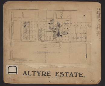
Plan - Subdivision Plan, Altyre Estate, 1920, 1920
... real estate firm - J. R. Mathers and McMillan, 136 Cotham Road, Kew. The Plans in the collection are rarely in pristine form, being working plans on which the agent would write notes and record lots sold and the prices of these. The subdivision plans are historically significant examples of the growth of urban Melbourne from the beginning of the 20th Century up until the 1980s. A number of the plans are double-sided and often include a photograph on the reverse. A number of the latter are by noted photographers such as J.E. Barnes. subdivision plans - kew Altyre Estate – Kew (Vic ...Pru Sanderson, in her groundbreaking ‘City of Kew Urban Conservation Study : Volume 2 - Development History’ (1988), summarised the periods of urban development and subdivisions of land in Kew. The periods that she identified included 1845-1880, 1880-1893, 1893-1921, 1921-1933, 1933-1943, and Post-War Development. These periods were selected as they represented periods of rapid growth or decline in urban development. An obvious starting point for Sanderson’s groupings involved population growth and the associated economic cycles. These cycles also highlighted urban expansion onto land that was predominantly rural, although in other cases it represented the decline and breakup of large estates. A number of the plans in the Kew Historical Society’s collection can also be found in other collections, such as those of the State Library of Victoria and the Boroondara Library Service. A number are however unique to the collection.The Kew Historical Society collection includes almost 100 subdivision plans pertaining to suburbs of the City of Melbourne. Most of these are of Kew, Kew East or Studley Park, although a smaller number are plans of Camberwell, Deepdene, Balwyn and Hawthorn. It is believed that the majority of the plans were gifted to the Society by persons connected with the real estate firm - J. R. Mathers and McMillan, 136 Cotham Road, Kew. The Plans in the collection are rarely in pristine form, being working plans on which the agent would write notes and record lots sold and the prices of these. The subdivision plans are historically significant examples of the growth of urban Melbourne from the beginning of the 20th Century up until the 1980s. A number of the plans are double-sided and often include a photograph on the reverse. A number of the latter are by noted photographers such as J.E. Barnes.The Altyre Estate was advertised for sale by auction in 1920. A colour lithograph in the State Library of Victoria, in contrast to this monochrome version, notes the proximity of the subdivision to the Auburn Heights Bowling Club and to a range of transport options. The subdivision included fifty-one allotments as well as the original house ‘Altyre’ in Barkers Road. This version includes the amounts paid as deposit on a number of lots.subdivision plans - kew, altyre estate – kew (vic), barkers road – kew (vic), walsh street – kew (vic), ross street – kew (vic), loxton street – kew (vic), mount street – kew (vic), auburn heights bowling club, altyre -
 Kew Historical Society Inc
Plan - Subdivision Plan, Wimba Estate, Kew, c.1925-c.1929, ca. 1925-ca. 1929
... real estate and financial agents. The numerous subdivision plans in the Kew Historical Society's collection represent working documents, ranging from the initial sketches made in planning a subdivision to printed plans on which auctioneers or agents listed the prices for which individual lots were sold. In a number of cases, the reverse of a subdivision plan in the collection includes a photograph of a house that was also for sale by the agent. These photographs provide significant heritage information relating house design and decoration, fencing and household gardens. wimba estate subdivision plans - kew parkhill road – kew (vic ...Pru Sanderson, in her groundbreaking ‘City of Kew Urban Conservation Study : Volume 2 - Development History’ (1988), summarised the periods of urban development and subdivisions of land in Kew. The periods that she identified included 1845-1880, 1880-1893, 1893-1921, 1921-1933, 1933-1943, and Post-War Development. These periods were selected as they represented periods of rapid growth or decline in urban development. An obvious starting point for Sanderson’s groupings involved population growth and the associated economic cycles. These cycles also highlighted urban expansion onto land that was predominantly rural, although in other cases it represented the decline and breakup of large estates. A number of the plans in the Kew Historical Society’s collection can also be found in other collections, such as those of the State Library of Victoria and the Boroondara Library Service. A number are however unique to the collection.Subdivision plans are historically important documents used as evidence of the growth of suburbs in Australia. They frequently provide information about when the land was sold on which a built structure was subsequently constructed as well as evidence relating to surveyors and real estate and financial agents. The numerous subdivision plans in the Kew Historical Society's collection represent working documents, ranging from the initial sketches made in planning a subdivision to printed plans on which auctioneers or agents listed the prices for which individual lots were sold. In a number of cases, the reverse of a subdivision plan in the collection includes a photograph of a house that was also for sale by the agent. These photographs provide significant heritage information relating house design and decoration, fencing and household gardens.In 1925, the City of Kew called for tenders for the construction of Wimba Avenue, Cadow Street and Lalla Street. Subsequent advertisements for the sale of land in Wimba Avenue continued from 1926 to 1929. The 18 lots (and a further five allotments on the eastern side of the street) offered for sale were unofficially described in the subdivision plan as the ‘Wimba Estate’. These lots began in Park Hill Road and extended almost to Cotham Road. The subdivision took its name from the house ‘Wimba’ in Cotham Road, which may have formed the southern boundary of the subdivision. (Wimba, at 235 Cotham Road was constructed between 1862-70). The Plan highlights the proximity and advantage of ‘electric’ trams in Cotham and Glenferrie Roads, and the Kew and Glenferrie Railway Stations. An oddity in the Plan is the reference to the electric tram terminus at Burke Road, given that the tramline had already been extended to Mont Albert in 1916.wimba estate, subdivision plans - kew, parkhill road – kew (vic.), normanby road – kew (vic.), wimba avenue – kew (vic.) -
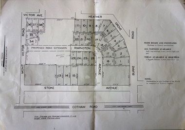 Kew Historical Society Inc
Plan, F R Simms & Son, Land for Private Sale: Cnr Victor Avenue and Mont Victor Road, Kew, 1950-1960
... real estate and financial agents. The numerous subdivision plans in the Kew Historical Society's collection represent working documents, ranging from the initial sketches made in planning a subdivision to printed plans on which auctioneers or agents listed the prices for which individual lots were sold. In a number of cases, the reverse of a subdivision plan in the collection includes a photograph of a house that was also for sale by the agent. These photographs provide significant heritage information relating house design and decoration, fencing and household gardens. subdivision plans - kew rimington avenue -- kew (vic ...George Rimington established The Parkhill Nursery in 1877. By 1910, it was more commonly known as Rimington’s Nurseries and well known for its sale of violets. After World War II, Rimington’s Nurseries were gradually subdivided and sold. The 38 allotments were released in sections, including lots 34 to 36 on the corner of Mont Victor Road and Victor Avenue. Previous lots in the subdivision had bordered Burke Road, Rimington Avenue, Heather Grove, and Stoke Avenue. The selling point as it had been in comparable estates for a century were the proximity to transport, schools and churches, as well as the high location and excellent views. The subdivision plan shows most of the lots in the entire subdivision: 1-11, 13-26, and 34-38. Presumably, lot 12 and lots 27-33 were still to be released.Subdivision plans are historically important documents used as evidence of the growth of suburbs in Australia. They frequently provide information about when the land was sold on which a built structure was subsequently constructed as well as evidence relating to surveyors and real estate and financial agents. The numerous subdivision plans in the Kew Historical Society's collection represent working documents, ranging from the initial sketches made in planning a subdivision to printed plans on which auctioneers or agents listed the prices for which individual lots were sold. In a number of cases, the reverse of a subdivision plan in the collection includes a photograph of a house that was also for sale by the agent. These photographs provide significant heritage information relating house design and decoration, fencing and household gardens.Subdivision plan advertising five superb home sites among lots in Burke Road, Stoke Avenue, Victor Avenue, Mont Victor Road and Heather Grove.subdivision plans - kew, rimington avenue -- kew (vic.), heather grove -- kew (vic), stoke avenue -- kew (vic.), burke road -- kew (vic.), mont victor road -- kew (vic.) -
 Kew Historical Society Inc
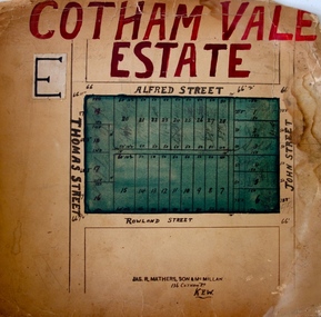
Plan - Subdivision Plan, Cotham Vale Estate, 1919
... real estate firm - J. R. Mathers and McMillan, 136 Cotham Road, Kew. The Plans in the collection are rarely in pristine form, being working plans on which the agent would write notes and record lots sold and the prices of these. The subdivision plans are historically significant examples of the growth of urban Melbourne from the beginning of the 20th Century up until the 1980s. A number of the plans are double-sided and often include a photograph on the reverse. A number of the latter are by noted photographers such as J.E. Barnes. subdivision plans - kew cotham vale estate rowland street -- Kew (Vic ...Pru Sanderson, in her groundbreaking ‘City of Kew Urban Conservation Study : Volume 2 - Development History’ (1988), summarised the periods of urban development and subdivisions of land in Kew. The periods that she identified included 1845-1880, 1880-1893, 1893-1921, 1921-1933, 1933-1943, and Post-War Development. These periods were selected as they represented periods of rapid growth or decline in urban development. An obvious starting point for Sanderson’s groupings involved population growth and the associated economic cycles. These cycles also highlighted urban expansion onto land that was predominantly rural, although in other cases it represented the decline and breakup of large estates. A number of the plans in the Kew Historical Society’s collection can also be found in other collections, such as those of the State Library of Victoria and the Boroondara Library Service. A number are however unique to the collection.The Kew Historical Society collection includes almost 100 subdivision plans pertaining to suburbs of the City of Melbourne. Most of these are of Kew, Kew East or Studley Park, although a smaller number are plans of Camberwell, Deepdene, Balwyn and Hawthorn. It is believed that the majority of the plans were gifted to the Society by persons connected with the real estate firm - J. R. Mathers and McMillan, 136 Cotham Road, Kew. The Plans in the collection are rarely in pristine form, being working plans on which the agent would write notes and record lots sold and the prices of these. The subdivision plans are historically significant examples of the growth of urban Melbourne from the beginning of the 20th Century up until the 1980s. A number of the plans are double-sided and often include a photograph on the reverse. A number of the latter are by noted photographers such as J.E. Barnes.The Cotham Vale Estate was a subdivision of land between Alfred, Thomas, Rowland and John Streets. It was promoted in the same time as the nearby Normanby Heights Estate. Cotham Vale included 28 allotments. Contemporary newspaper advertisements noted that the Estate ‘is most conveniently situated in a well elevated position, only 2 minutes from Cotham rd. Electric Cars, penny section to Kew station’.subdivision plans - kew, cotham vale estate, rowland street -- kew (vic.), thomas street -- kew (vic.), john street -- kew (vic.) -
![Escol Estate [Kew], 1940](/media/collectors/550653872162f11fb04854aa/items/59115843d0ce2b1f048f0fbb/item-media/591158fdd0ce2e1f04f1e0f5/item-fit-380x285.jpg?cb=6) Kew Historical Society Inc
Kew Historical Society IncPlan - Subdivision Plan, Escol Estate [Kew], 1940, 1940
... real estate firm - J. R. Mathers and McMillan, 136 Cotham Road, Kew. The Plans in the collection are rarely in pristine form, being working plans on which the agent would write notes and record lots sold and the prices of these. The subdivision plans are historically significant examples of the growth of urban Melbourne from the beginning of the 20th Century up until the 1980s. A number of the plans are double-sided and often include a photograph on the reverse. A number of the latter are by noted photographers such as J.E. Barnes. subdivision plans - kew Sackville Street – Kew (Vic ...Pru Sanderson, in her groundbreaking ‘City of Kew Urban Conservation Study : Volume 2 - Development History’ (1988), summarised the periods of urban development and subdivisions of land in Kew. The periods that she identified included 1845-1880, 1880-1893, 1893-1921, 1921-1933, 1933-1943, and Post-War Development. These periods were selected as they represented periods of rapid growth or decline in urban development. An obvious starting point for Sanderson’s groupings involved population growth and the associated economic cycles. These cycles also highlighted urban expansion onto land that was predominantly rural, although in other cases it represented the decline and breakup of large estates. A number of the plans in the Kew Historical Society’s collection can also be found in other collections, such as those of the State Library of Victoria and the Boroondara Library Service. A number are however unique to the collection.The Kew Historical Society collection includes almost 100 subdivision plans pertaining to suburbs of the City of Melbourne. Most of these are of Kew, Kew East or Studley Park, although a smaller number are plans of Camberwell, Deepdene, Balwyn and Hawthorn. It is believed that the majority of the plans were gifted to the Society by persons connected with the real estate firm - J. R. Mathers and McMillan, 136 Cotham Road, Kew. The Plans in the collection are rarely in pristine form, being working plans on which the agent would write notes and record lots sold and the prices of these. The subdivision plans are historically significant examples of the growth of urban Melbourne from the beginning of the 20th Century up until the 1980s. A number of the plans are double-sided and often include a photograph on the reverse. A number of the latter are by noted photographers such as J.E. Barnes.The ‘Escol Estate’ was a subdivision, which created Bramley Court, which runs south from Sackville Street between Evans Road and Orford Avenue. The subdivision was comprised of 12 lots. At the auction of the lots in May 1940, eight of the 12 allotments were sold. The land was sold subject to a restriction of only one private residence being erected on each lot.subdivision plans - kew, sackville street – kew (vic.), bramley court – kew (vic.) -
 Kew Historical Society Inc
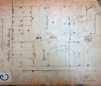
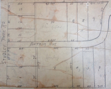
Plan - Subdivision Plan, Windella-Darnley Subdivision, Studley Park, 1920s
... real estate and financial agents. The numerous subdivision plans in the Kew Historical Society's collection represent working documents, ranging from the initial sketches made in planning a subdivision to printed plans on which auctioneers or agents listed the prices for which individual lots were sold. In a number of cases, the reverse of a subdivision plan in the collection includes a photograph of a house that was also for sale by the agent. These photographs provide significant heritage information relating house design and decoration, fencing and household gardens. subdivision plans - kew, studley park Windella Darnley Studley Park Road -- Kew (Vic ...Subdivision plans are historically important documents used as evidence of the growth of suburbs in Australia. They frequently provide information about when the land was sold on which a built structure was subsequently constructed as well as evidence relating to surveyors and real estate and financial agents. The numerous subdivision plans in the Kew Historical Society's collection represent working documents, ranging from the initial sketches made in planning a subdivision to printed plans on which auctioneers or agents listed the prices for which individual lots were sold. In a number of cases, the reverse of a subdivision plan in the collection includes a photograph of a house that was also for sale by the agent. These photographs provide significant heritage information relating house design and decoration, fencing and household gardens.Version 1 of two subdivision plans (the later one is MAP.0027) for the section of Studley Park Road near the Junction on the south side. Named in the subdivision are the mansions of Darley and Windella (now demolished). Before the subdivision of Darley and Windella, both houses fronted Studley Park Road. Both houses appear to be advertised as lots in the subdivision. Bisecting the subdivision is a street, Antrim Avenue that was never constructed. A street, which was subsequently constructed in this vicinity, was Merrion Place, which now runs between Studley Park Road and Highfield Grove. There are 14 proposed lots in this subdivision."Antrim Avenue. See over for new plan"subdivision plans - kew, studley park, windella, darnley, studley park road -- kew (vic.), merrion place -- kew (vic.), merrion grove -- kew (vic.), highbury grove -- kew (vic.) -
 Kew Historical Society Inc
Plan - Subdivision Plan, Windella-Darnley Subdivision, Studley Park, 1920s
... real estate and financial agents. T he numerous subdivision plans in the Kew Historical Society's collection represent working documents, ranging from the initial sketches made in planning a subdivision to printed plans on which auctioneers or agents listed the prices for which individual lots were sold. In a number of cases, the reverse of a subdivision plan in the collection includes a photograph of a house that was also for sale by the agent. These photographs provide significant heritage information relating house design and decoration, fencing and household gardens. subdivision plans - kew, studley park Windella Darnley Antrim Avenue -- Kew (Vic ...Subdivision plans are historically important documents used as evidence of the growth of suburbs in Australia. They frequently provide information about when the land was sold on which a built structure was subsequently constructed as well as evidence relating to surveyors and real estate and financial agents. The numerous subdivision plans in the Kew Historical Society's collection represent working documents, ranging from the initial sketches made in planning a subdivision to printed plans on which auctioneers or agents listed the prices for which individual lots were sold. In a number of cases, the reverse of a subdivision plan in the collection includes a photograph of a house that was also for sale by the agent. These photographs provide significant heritage information relating house design and decoration, fencing and household gardens.Version 2 of two subdivision plans (the earlier is 2016.0305.1) for the section of Studley Park Road near the Junction on the south side. Named in the subdivision are the mansions of Darley and Windella (now demolished). Before the subdivision of Darley and Windella, both houses fronted Studley Park Road. Both houses appear to be advertised as lots in the subdivision. Bisecting the subdivision is a street, Antrim Avenue that was never constructed. A street, which was subsequently constructed in this vicinity, was Merrion Place, which now runs between Studley Park Road and Highfield Grove. There are 13 proposed lots in this subdivision in contrast to the earlier plan. This resulted from larger lots being proposed for Studley Park Road.subdivision plans - kew, studley park, windella, darnley, antrim avenue -- kew (vic.), studley park road -- kew (vic.), merrion place -- kew (vic.), merrion grove -- kew (vic.), highbury grove -- kew (vic.) -
 Kew Historical Society Inc
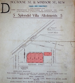
Plan, J R Mathers & McMillan, 5 Splendid vVlla Allotments,: Segtoune St. & Windsor St., Kew, 1928
... real estate and financial agents. The numerous subdivision plans in the Kew Historical Society's collection represent working documents, ranging from the initial sketches made in planning a subdivision to printed plans on which auctioneers or agents listed the prices for which individual lots were sold. In a number of cases, the reverse of a subdivision plan in the collection includes a photograph of a house that was also for sale by the agent. These photographs provide significant heritage information relating house design and decoration, fencing and household gardens. subdivision plans - kew segtoune street -- kew (vic ...Prue Sanderson, in her groundbreaking ‘City of Kew Urban Conservation Study : Volume 2 - Development History’ (1988), summarised the periods of urban development and subdivisions of land in Kew. The periods that she identified included 1845-1880, 1880-1893, 1893-1921, 1921-1933, 1933-1943, and Post-War Development. These periods were selected as they represented periods of rapid growth or decline in urban development. An obvious starting point for Sanderson’s groupings involved population growth and the associated economic cycles. These cycles also highlighted urban expansion onto land that was predominantly rural, although in other cases it represented the decline and breakup of large estates. A number of the plans in the Kew Historical Society’s collection can also be found in other collections, such as those of the State Library of Victoria and the Boroondara Library Service. A number are however unique to the collection.Subdivision plans are historically important documents used as evidence of the growth of suburbs in Australia. They frequently provide information about when the land was sold on which a built structure was subsequently constructed as well as evidence relating to surveyors and real estate and financial agents. The numerous subdivision plans in the Kew Historical Society's collection represent working documents, ranging from the initial sketches made in planning a subdivision to printed plans on which auctioneers or agents listed the prices for which individual lots were sold. In a number of cases, the reverse of a subdivision plan in the collection includes a photograph of a house that was also for sale by the agent. These photographs provide significant heritage information relating house design and decoration, fencing and household gardens.In 1928, five residential allotments bordering Segtoune and Windsor Streets were advertised for sale as part of a subdivision. Four of the blocks faced Segtoune Avenue. The auctioneers proclaimed the advantages of the sites: ‘Situate one minute from the High Street Electric Tram, which now runs direct to Spencer Street via Bridge Road and Flinders Street. Opposite the East Kew Railway Station (Outer Circle Line), which may be reopened In connection with the new Line from Kew to Doncaster; Adjacent lo the Kew Recreation Reserve, Sports Oval, and Swimming Bath; Half Minute from the Shopping Centre of East Kew, Accessible to the State School and Other Educational Centres’. The Harp of Erin Hotel and the route of the Outer Circle Railway line are marked on the plan. The Recreation Reserve and Sport Oval refer to Victoria Park. The Swimming Baths were located on the site of the current Kew Recreation Centre.subdivision plans - kew, segtoune street -- kew (vic.), windsor street -- kew (vic.) -
 Kew Historical Society Inc
Plan - Subdivision Plan, High Street, Kew, 1920-1935
... real estate firm - J. R. Mathers and McMillan, 136 Cotham Road, Kew. The Plans in the collection are rarely in pristine form, being working plans on which the agent would write notes and record lots sold and the prices of these. The subdivision plans are historically significant examples of the growth of urban Melbourne from the beginning of the 20th Century up until the 1980s. A number of the plans are double-sided and often include a photograph on the reverse. A number of the latter are by noted photographers such as J.E. Barnes. subdivision plans - kew High Street -- Kew (Vic ...Pru Sanderson, in her groundbreaking ‘City of Kew Urban Conservation Study : Volume 2 - Development History’ (1988), summarised the periods of urban development and subdivisions of land in Kew. The periods that she identified included 1845-1880, 1880-1893, 1893-1921, 1921-1933, 1933-1943, and Post-War Development. These periods were selected as they represented periods of rapid growth or decline in urban development. An obvious starting point for Sanderson’s groupings involved population growth and the associated economic cycles. These cycles also highlighted urban expansion onto land that was predominantly rural, although in other cases it represented the decline and breakup of large estates. A number of the plans in the Kew Historical Society’s collection can also be found in other collections, such as those of the State Library of Victoria and the Boroondara Library Service. A number are however unique to the collection.The Kew Historical Society collection includes almost 100 subdivision plans pertaining to suburbs of the City of Melbourne. Most of these are of Kew, Kew East or Studley Park, although a smaller number are plans of Camberwell, Deepdene, Balwyn and Hawthorn. It is believed that the majority of the plans were gifted to the Society by persons connected with the real estate firm - J. R. Mathers and McMillan, 136 Cotham Road, Kew. The Plans in the collection are rarely in pristine form, being working plans on which the agent would write notes and record lots sold and the prices of these. The subdivision plans are historically significant examples of the growth of urban Melbourne from the beginning of the 20th Century up until the 1980s. A number of the plans are double-sided and often include a photograph on the reverse. A number of the latter are by noted photographers such as J.E. Barnes.A roughly drawn and faded actual or projected subdivision of a parcel of land bordering on High and Mary Streets. The plan shows five allotments facing High Street and at their rear, another allotment facing Mary Street. In 1906, when the Board of Works surveyors completed Detail Plan 1589, the allotment in Mary Street is shown to include a building. The section of land attached to this building is shown to be undeveloped, thus making a further subdivision possible.subdivision plans - kew, high street -- kew (vic.), mary street -- kew (vic.) -
 Kew Historical Society Inc
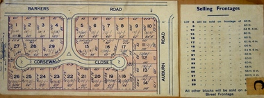
Plan - Subdivision Plan, Corsewall Estate, 1938
... real estate firm - J. R. Mathers and McMillan, 136 Cotham Road, Kew. The Plans in the collection are rarely in pristine form, being working plans on which the agent would write notes and record lots sold and the prices of these. The subdivision plans are historically significant examples of the growth of urban Melbourne from the beginning of the 20th Century up until the 1980s. A number of the plans are double-sided and often include a photograph on the reverse. A number of the latter are by noted photographers such as J.E. Barnes. subdivision plans - hawthorn Corsewall Estate -- Hawthorn (Vic ...The Kew Historical Society collection includes almost 100 subdivision plans pertaining to suburbs of the City of Melbourne. Most of these are of Kew, Kew East or Studley Park, although a smaller number are plans of Camberwell, Deepdene, Balwyn and Hawthorn. It is believed that the majority of the plans were gifted to the Society by persons connected with the real estate firm - J. R. Mathers and McMillan, 136 Cotham Road, Kew. The Plans in the collection are rarely in pristine form, being working plans on which the agent would write notes and record lots sold and the prices of these. The subdivision plans are historically significant examples of the growth of urban Melbourne from the beginning of the 20th Century up until the 1980s. A number of the plans are double-sided and often include a photograph on the reverse. A number of the latter are by noted photographers such as J.E. Barnes.The Corsewall Estate was a subdivision, bordering on Barkers Road and Auburn Road, which created Corsewall Close. This relatively late subdivision included 29 allotments. The subdivision plan includes the dimensions of each lot as well as the width of the existing and projected roads and turning circles. The Corsewall Close Precinct is now listed on the Victorian Heritage Database (HO147) and is noted for its ‘consistent flat-type development over the entire street, which has been cleverly designed to make multi-unit dwellings appear as single buildings’.subdivision plans - hawthorn, corsewall estate -- hawthorn (vic.) -
 Kew Historical Society Inc
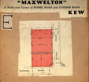
Plan - Subdivision Plan, Maxwelton, Kew, 1920-1940
... real estate firm - J. R. Mathers and McMillan, 136 Cotham Road, Kew. The Plans in the collection are rarely in pristine form, being working plans on which the agent would write notes and record lots sold and the prices of these. The subdivision plans are historically significant examples of the growth of urban Melbourne from the beginning of the 20th Century up until the 1980s. A number of the plans are double-sided and often include a photograph on the reverse. A number of the latter are by noted photographers such as J.E. Barnes. subdivision plans - kew Mazwelton subdivision Burke Road -- Kew (Vic ...Pru Sanderson, in her groundbreaking ‘City of Kew Urban Conservation Study : Volume 2 - Development History’ (1988), summarised the periods of urban development and subdivisions of land in Kew. The periods that she identified included 1845-1880, 1880-1893, 1893-1921, 1921-1933, 1933-1943, and Post-War Development. These periods were selected as they represented periods of rapid growth or decline in urban development. An obvious starting point for Sanderson’s groupings involved population growth and the associated economic cycles. These cycles also highlighted urban expansion onto land that was predominantly rural, although in other cases it represented the decline and breakup of large estates. A number of the plans in the Kew Historical Society’s collection can also be found in other collections, such as those of the State Library of Victoria and the Boroondara Library Service. A number are however unique to the collection.The Kew Historical Society collection includes almost 100 subdivision plans pertaining to suburbs of the City of Melbourne. Most of these are of Kew, Kew East or Studley Park, although a smaller number are plans of Camberwell, Deepdene, Balwyn and Hawthorn. It is believed that the majority of the plans were gifted to the Society by persons connected with the real estate firm - J. R. Mathers and McMillan, 136 Cotham Road, Kew. The Plans in the collection are rarely in pristine form, being working plans on which the agent would write notes and record lots sold and the prices of these. The subdivision plans are historically significant examples of the growth of urban Melbourne from the beginning of the 20th Century up until the 1980s. A number of the plans are double-sided and often include a photograph on the reverse. A number of the latter are by noted photographers such as J.E. Barnes.The subdivision, ‘Maxwelton’, included four lots in East Kew, at the northwest corner of Burke Road and Cotham Road. Lot 3 is identified as the location of an existing house. The site of the subdivision equates to that parcel of land where a contemporary block of three storey apartments at 1245 Burke Road is now located.subdivision plans - kew, mazwelton subdivision, burke road -- kew (vic.), cotham road -- kew (vic.) -
 Kew Historical Society Inc
Plan - Subdivision Plan, Lodged Plan No.6518, 1920-1940
... real estate firm - J. R. Mathers and McMillan, 136 Cotham Road, Kew. The Plans in the collection are rarely in pristine form, being working plans on which the agent would write notes and record lots sold and the prices of these. The subdivision plans are historically significant examples of the growth of urban Melbourne from the beginning of the 20th Century up until the 1980s. A number of the plans are double-sided and often include a photograph on the reverse. subdivision plans - balwyn Deepdene Whitehorse Road -- Deepdene (Vic ...The Kew Historical Society collection includes almost 100 subdivision plans pertaining to suburbs of the City of Melbourne. Most of these are of Kew, Kew East or Studley Park, although a smaller number are plans of Camberwell, Deepdene, Balwyn and Hawthorn. It is believed that the majority of the plans were gifted to the Society by persons connected with the real estate firm - J. R. Mathers and McMillan, 136 Cotham Road, Kew. The Plans in the collection are rarely in pristine form, being working plans on which the agent would write notes and record lots sold and the prices of these. The subdivision plans are historically significant examples of the growth of urban Melbourne from the beginning of the 20th Century up until the 1980s. A number of the plans are double-sided and often include a photograph on the reverse. Reconciling this hand-drawn subdivision plan with a modern map of the area is initially a challenge due to a change of street names. Argyle Road in the centre of the subdivision was to be renamed Deepdene Road, and the street named Deepdene Road on the plan was to become Deepdene Place. Of interest is the nursery on the corner of Argyle and Whitehorse Roads. During this period there were a number of nurseries servicing the Kew and Balwyn areas. The subdivision was essentially of the land formerly occupied by the house 'Deepdene'.subdivision plans - balwyn, deepdene, whitehorse road -- deepdene (vic.), deepdene road -- deepdene (vic.), burke road -- deepdene (vic.) -
 Kew Historical Society Inc
Plan - Subdivision Plan, Violet Farm Estate, 1927
... real estate firm - J. R. Mathers and McMillan, 136 Cotham Road, Kew. The Plans in the collection are rarely in pristine form, being working plans on which the agent would write notes and record lots sold and the prices of these.The subdivision plans are historically significant examples of the growth of urban Melbourne from the beginning of the 20th Century up until the 1980s. A number of the plans are double-sided and often include a photograph on the reverse. subdivision plans - east kew violet farm estate violet grove -- kew (vic ...Pru Sanderson, in her groundbreaking ‘City of Kew Urban Conservation Study : Volume 2 - Development History’ (1988), summarised the periods of urban development and subdivisions of land in Kew. The periods that she identified included 1845-1880, 1880-1893, 1893-1921, 1921-1933, 1933-1943, and Post-War Development. These periods were selected as they represented periods of rapid growth or decline in urban development. An obvious starting point for Sanderson’s groupings involved population growth and the associated economic cycles. These cycles also highlighted urban expansion onto land that was predominantly rural, although in other cases it represented the decline and breakup of large estates. A number of the plans in the Kew Historical Society’s collection can also be found in other collections, such as those of the State Library of Victoria and the Boroondara Library Service. A number are however unique to the collection.The Kew Historical Society collection includes almost 100 subdivision plans pertaining to suburbs of the City of Melbourne. Most of these are of Kew, Kew East or Studley Park, although a smaller number are plans of Camberwell, Deepdene, Balwyn and Hawthorn. It is believed that the majority of the plans were gifted to the Society by persons connected with the real estate firm - J. R. Mathers and McMillan, 136 Cotham Road, Kew. The Plans in the collection are rarely in pristine form, being working plans on which the agent would write notes and record lots sold and the prices of these.The subdivision plans are historically significant examples of the growth of urban Melbourne from the beginning of the 20th Century up until the 1980s. A number of the plans are double-sided and often include a photograph on the reverse. A subdivision plan for nineteen ‘bonny, airy building blocks’ on either side of Violet Grove, Kew East. Violet Grove runs between High Street and Harp Road. Like many other subdivisions in Kew and East Kew, older houses (Lots 1 and 13) were often included in the subdivision. Such houses were in some instances the original properties that were subdivided, or in the case of the Violet Grove subdivision, new houses such as the weatherboard villa on lot 13. This villa is advertised as having a tiled roof, 5 rooms, panelled hall, double doors (Rooms 14 x 12 ft. 6 in. (2) 14 x 12, 12 x 11, 13 x 11). A bricked front verandah, a tiled stove recess and existing sewerage connection added to its saleable potential. Water, electric light and power, and gas were all offered as part of the deal. Violet Grove now has about 35 houses, which indicates that the 19 lots of the subdivision were to be further subdivided by purchasers. [A similar plan is in the Batten & Percy Collection of the State Library of Victoria.]subdivision plans - east kew, violet farm estate, violet grove -- kew (vic.), boorool road -- kew (vic.), harp road -- kew east (vic.) -
 Kew Historical Society Inc
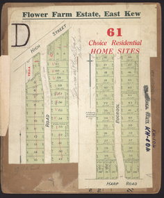
Plan - Subdivision Plan, Flower Farm Estate, East Kew, 1922
... real estate firm - J. R. Mathers and McMillan, 136 Cotham Road, Kew. The Plans in the collection are rarely in pristine form, being working plans on which the agent would write notes and record lots sold and the prices of these. The subdivision plans are historically significant examples of the growth of urban Melbourne from the beginning of the 20th Century up until the 1980s. A number of the plans are double-sided and often include a photograph on the reverse. subdivision plans - east kew flower farm estate High Street - Kew East (Vic ...Pru Sanderson, in her groundbreaking ‘City of Kew Urban Conservation Study : Volume 2 - Development History’ (1988), summarised the periods of urban development and subdivisions of land in Kew. The periods that she identified included 1845-1880, 1880-1893, 1893-1921, 1921-1933, 1933-1943, and Post-War Development. These periods were selected as they represented periods of rapid growth or decline in urban development. An obvious starting point for Sanderson’s groupings involved population growth and the associated economic cycles. These cycles also highlighted urban expansion onto land that was predominantly rural, although in other cases it represented the decline and breakup of large estates. A number of the plans in the Kew Historical Society’s collection can also be found in other collections, such as those of the State Library of Victoria and the Boroondara Library Service. A number are however unique to the collection.The Kew Historical Society collection includes almost 100 subdivision plans pertaining to suburbs of the City of Melbourne. Most of these are of Kew, Kew East or Studley Park, although a smaller number are plans of Camberwell, Deepdene, Balwyn and Hawthorn. It is believed that the majority of the plans were gifted to the Society by persons connected with the real estate firm - J. R. Mathers and McMillan, 136 Cotham Road, Kew. The Plans in the collection are rarely in pristine form, being working plans on which the agent would write notes and record lots sold and the prices of these. The subdivision plans are historically significant examples of the growth of urban Melbourne from the beginning of the 20th Century up until the 1980s. A number of the plans are double-sided and often include a photograph on the reverse. The subdivision called the ‘Flower Farm Estate’ in Kew East occurred in 1922. It included 61 lots on either side of Boorool Road between High Street and Harp Road. In an advertisement in The Argus in the same year, the proximity of the estate to the newly erected shops at the corner of Harp Road and High Street is noted. The Flower Farm Estate and similar subdivisions in Kew East were assisted by the extension of the High Street tramline in 1924.subdivision plans - east kew, flower farm estate, high street - kew east (vic.), boorool road -- kew east (vic.), harp road -- kew east (vic.) -
 Kew Historical Society Inc
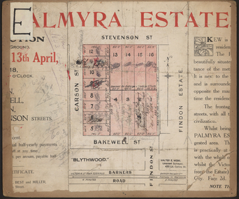
Plan - Subdivision Plan, Palmyra Estate, 1918
... real estate firm - J. R. Mathers & McMillan, 136 Cotham Road, Kew. The Plans in the collection are rarely in pristine form, being working plans on which the agent would write notes and record lots sold and the prices of these. The subdivision plans are historically significant examples of the growth of urban Melbourne from the beginning of the 20th Century up until the 1980s. A number of the plans are double-sided and often include a photograph on the reverse. subdivision plans - kew, studley park palymyra estate Stevenson Street -- Kew (Vic ...Pru Sanderson, in her groundbreaking ‘City of Kew Urban Conservation Study : Volume 2 - Development History’ (1988), summarised the periods of urban development and subdivisions of land in Kew. The periods that she identified included 1845-1880, 1880-1893, 1893-1921, 1921-1933, 1933-1943, and Post-War Development. These periods were selected as they represented periods of rapid growth or decline in urban development. An obvious starting point for Sanderson’s groupings involved population growth and the associated economic cycles. These cycles also highlighted urban expansion onto land that was predominantly rural, although in other cases it represented the decline and breakup of large estates. A number of the plans in the Kew Historical Society’s collection can also be found in other collections, such as those of the State Library of Victoria and the Boroondara Library Service. A number are however unique to the collection.The Kew Historical Society collection includes almost 100 subdivision plans pertaining to suburbs of the City of Melbourne. Most of these are of Kew, Kew East or Studley Park, although a smaller number are plans of Camberwell, Deepdene, Balwyn and Hawthorn. It is believed that the majority of the plans were gifted to the Society by persons connected with the real estate firm - J. R. Mathers & McMillan, 136 Cotham Road, Kew. The Plans in the collection are rarely in pristine form, being working plans on which the agent would write notes and record lots sold and the prices of these. The subdivision plans are historically significant examples of the growth of urban Melbourne from the beginning of the 20th Century up until the 1980s. A number of the plans are double-sided and often include a photograph on the reverse. In 1918, Punch reported the sale of the Palmyra Estate. ‘Adjoining the Findon Estate at Kew is Palmyra, one of the most charming localities in this most desirable of all suburbs. Palmyra has frontages to Findon, Bakewell, Carson and Stevenson streets. Facing Carson street are eight blocks of 60 by 140; on Stevenson-street four of 60 by 232; and there are four of 60 by 233 on Bakewell-street.’ [Bakewell Street and Findon Street were later to be amalgamated into Findon Crescent.]subdivision plans - kew, studley park, palymyra estate, stevenson street -- kew (vic.), carson street -- kew (vic.), bakewell street (findon crescent) -- kew (vic.) -
 Kew Historical Society Inc
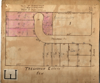
Plan - Subdivision Plan, Tregarron Estate, Kew, c.1929
... real estate and financial agents. The numerous subdivision plans in the Kew Historical Society's collection represent working documents, ranging from the initial sketches made in planning a subdivision to printed plans on which auctioneers or agents listed the prices for which individual lots were sold. In a number of cases, the reverse of a subdivision plan in the collection includes a photograph of a house that was also for sale by the agent. These photographs provide significant heritage information relating house design and decoration, fencing and household gardens. subdivision plans - kew tregarron estate Tregarron Avenue -- Kew (Vic ...Pru Sanderson, in her groundbreaking ‘City of Kew Urban Conservation Study : Volume 2 - Development History’ (1988), summarised the periods of urban development and subdivisions of land in Kew. The periods that she identified included 1845-1880, 1880-1893, 1893-1921, 1921-1933, 1933-1943, and Post-War Development. These periods were selected as they represented periods of rapid growth or decline in urban development. An obvious starting point for Sanderson’s groupings involved population growth and the associated economic cycles. These cycles also highlighted urban expansion onto land that was predominantly rural, although in other cases it represented the decline and breakup of large estates. A number of the plans in the Kew Historical Society’s collection can also be found in other collections, such as those of the State Library of Victoria and the Boroondara Library Service. A number are however unique to the collection.Subdivision plans are historically important documents used as evidence of the growth of suburbs in Australia. They frequently provide information about when the land was sold on which a built structure was subsequently constructed as well as evidence relating to surveyors and real estate and financial agents. The numerous subdivision plans in the Kew Historical Society's collection represent working documents, ranging from the initial sketches made in planning a subdivision to printed plans on which auctioneers or agents listed the prices for which individual lots were sold. In a number of cases, the reverse of a subdivision plan in the collection includes a photograph of a house that was also for sale by the agent. These photographs provide significant heritage information relating house design and decoration, fencing and household gardens.In January 1929, the Kew City Council called for tenders to construct Tregarron Avenue. The subdivision of the Tregarron Estate in Kew was for 11 lots bordering Tregarron Avenue and its entrance from Burke Road. The plan includes annotations that indicate the measurement of each block and the placement of the drainage and sewerage easements. This plan is interesting for a number of factors. The house blocks today have different street numbers, some blocks were to be further subdivided, and at the time of the subdivision, alterations were still being made to the extent of lots offered; lots 2 and 3 on the plan were subdivided and reoriented.subdivision plans - kew, tregarron estate, tregarron avenue -- kew (vic.), burke road -- kew (vic.) -
 Kew Historical Society Inc
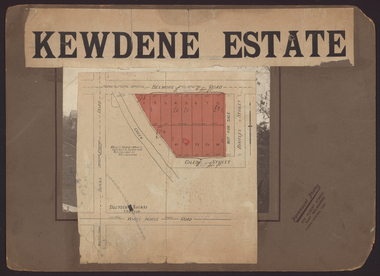
Plan - Subdivision Plan, Kewdene Estate, 1937-1939
... real estate firm - J. R. Mathers & McMillan, 136 Cotham Road, Kew. The Plans in the collection are rarely in pristine form, being working plans on which the agent would write notes and record lots sold and the prices of these. The subdivision plans are historically significant examples of the growth of urban Melbourne from the beginning of the 20th Century up until the 1980s. A number of the plans are double-sided and often include a photograph on the reverse. subdivision plans - east kew kewdene estate belmore road -- kew east (vic ...Pru Sanderson, in her groundbreaking ‘City of Kew Urban Conservation Study : Volume 2 - Development History’ (1988), summarised the periods of urban development and subdivisions of land in Kew. The periods that she identified included 1845-1880, 1880-1893, 1893-1921, 1921-1933, 1933-1943, and Post-War Development. These periods were selected as they represented periods of rapid growth or decline in urban development. An obvious starting point for Sanderson’s groupings involved population growth and the associated economic cycles. These cycles also highlighted urban expansion onto land that was predominantly rural, although in other cases it represented the decline and breakup of large estates. A number of the plans in the Kew Historical Society’s collection can also be found in other collections, such as those of the State Library of Victoria and the Boroondara Library Service. A number are however unique to the collection.The Kew Historical Society collection includes almost 100 subdivision plans pertaining to suburbs of the City of Melbourne. Most of these are of Kew, Kew East or Studley Park, although a smaller number are plans of Camberwell, Deepdene, Balwyn and Hawthorn. It is believed that the majority of the plans were gifted to the Society by persons connected with the real estate firm - J. R. Mathers & McMillan, 136 Cotham Road, Kew. The Plans in the collection are rarely in pristine form, being working plans on which the agent would write notes and record lots sold and the prices of these. The subdivision plans are historically significant examples of the growth of urban Melbourne from the beginning of the 20th Century up until the 1980s. A number of the plans are double-sided and often include a photograph on the reverse. The advertisement for the ‘Kewdene Estate’ subdivision is pasted over a photograph of a property for sale. This is typical of the reuse of promotional materials in the period during, and subsequent to World War I. The subdivision included 14 lots bordered by Belmore Road, Birtles Street and Giles Street. On the other side of the subdivision [Glass] Creek is noted. The subdivision plan also shows part of the Outer Circle Railway and Deepdene Railway Station.subdivision plans - east kew, kewdene estate, belmore road -- kew east (vic.), giles street -- kew east (vic.) -
 Kew Historical Society Inc
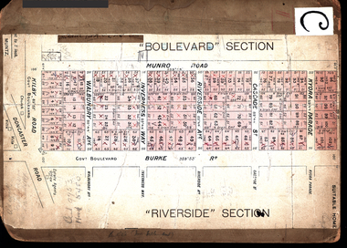
Plan - Subdivision Plan, Boulevard Estate - Boulevard Section, 1930-1936
... real estate firm - J. R. Mathers and McMillan, 136 Cotham Road, Kew. The Plans in the collection are rarely in pristine form, being working plans on which the agent would write notes and record lots sold and the prices of these. The subdivision plans are historically significant examples of the growth of urban Melbourne from the beginning of the 20th Century up until the 1980s. A number of the plans are double-sided and often include a photograph on the reverse. subdivision plans - east kew boulevard estate Munro Road -- Kew East (Vic ...Pru Sanderson, in her groundbreaking ‘City of Kew Urban Conservation Study : Volume 2 - Development History’ (1988), summarised the periods of urban development and subdivisions of land in Kew. The periods that she identified included 1845-1880, 1880-1893, 1893-1921, 1921-1933, 1933-1943, and Post-War Development. These periods were selected as they represented periods of rapid growth or decline in urban development. An obvious starting point for Sanderson’s groupings involved population growth and the associated economic cycles. These cycles also highlighted urban expansion onto land that was predominantly rural, although in other cases it represented the decline and breakup of large estates. A number of the plans in the Kew Historical Society’s collection can also be found in other collections, such as those of the State Library of Victoria and the Boroondara Library Service. A number are however unique to the collection.The Kew Historical Society collection includes almost 100 subdivision plans pertaining to suburbs of the City of Melbourne. Most of these are of Kew, Kew East or Studley Park, although a smaller number are plans of Camberwell, Deepdene, Balwyn and Hawthorn. It is believed that the majority of the plans were gifted to the Society by persons connected with the real estate firm - J. R. Mathers and McMillan, 136 Cotham Road, Kew. The Plans in the collection are rarely in pristine form, being working plans on which the agent would write notes and record lots sold and the prices of these. The subdivision plans are historically significant examples of the growth of urban Melbourne from the beginning of the 20th Century up until the 1980s. A number of the plans are double-sided and often include a photograph on the reverse. This plan shows a subdivision with two sections: the ‘Boulevard Section’ and the ‘Riverside Section’. The first of these sections bordered Burke Road between Kilby Road and the farm beside the Yarra. Kilby Road, Munro Road, Burke Road and Old Burke Road bordered the 102 lots in the Boulevard Section of the plan. The streets within the Section included Walbundry Avenue, Inverness Way, Riverside Avenue, Cascade Street and Kyora Parade. These street names, at least in this subdivision plan linked the two Sections of the subdivision. At a later date, the City of Kew decided to alter the street names. Walbundry, Inverness, Riverside, Cascade and Kyora were all renamed as ‘Drives’ (e.g. Kyora Drive). The subdivision plan is of interest in that it names High Street in Kew as Doncaster Road. It also shows the location of the wooden church that was later removed to Yarraville on the corner of Kilby Road and High Street. The plan predates later developments such as the S. E. Dickens Supermarket.subdivision plans - east kew, boulevard estate, munro road -- kew east (vic.), kilby road -- kew east (vic.), burke road -- kew east (vic.), walbundry avenue -- kew east (vic.), inverness way -- kew east (vic.), riverside avenue -- kew east (vic.), cascade drive -- kew east (vic.), nyora parade -- kew east (vic.) -
 Kew Historical Society Inc
Plan - Subdivision Plan, Goldthorns Hill Estate, 1925
... real estate firm - J. R. Mathers and McMillan, 136 Cotham Road, Kew. The Plans in the collection are rarely in pristine form, being working plans on which the agent would write notes and record lots sold and the prices of these. The subdivision plans are historically significant examples of the growth of urban Melbourne from the beginning of the 20th Century up until the 1980s. A number of the plans are double-sided and often include a photograph on the reverse. Goldthorns Avenue -- Kew East (Vic ...Pru Sanderson, in her groundbreaking ‘City of Kew Urban Conservation Study : Volume 2 - Development History’ (1988), summarised the periods of urban development and subdivisions of land in Kew. The periods that she identified included 1845-1880, 1880-1893, 1893-1921, 1921-1933, 1933-1943, and Post-War Development. These periods were selected as they represented periods of rapid growth or decline in urban development. An obvious starting point for Sanderson’s groupings involved population growth and the associated economic cycles. These cycles also highlighted urban expansion onto land that was predominantly rural, although in other cases it represented the decline and breakup of large estates. A number of the plans in the Kew Historical Society’s collection can also be found in other collections, such as those of the State Library of Victoria and the Boroondara Library Service. A number are however unique to the collection.The Kew Historical Society collection includes almost 100 subdivision plans pertaining to suburbs of the City of Melbourne. Most of these are of Kew, Kew East or Studley Park, although a smaller number are plans of Camberwell, Deepdene, Balwyn and Hawthorn. It is believed that the majority of the plans were gifted to the Society by persons connected with the real estate firm - J. R. Mathers and McMillan, 136 Cotham Road, Kew. The Plans in the collection are rarely in pristine form, being working plans on which the agent would write notes and record lots sold and the prices of these. The subdivision plans are historically significant examples of the growth of urban Melbourne from the beginning of the 20th Century up until the 1980s. A number of the plans are double-sided and often include a photograph on the reverse. The Goldthorns Hill Estate subdivision was first put up for auction in 1925. The subdivision took its name from the mansion ‘Goldthorns’, shown on the plan between Normanby Road and Lady Loch’s Drive. Contemporary advertisements describe forty-three home sites being fro sale, yet only forty-one appear on this plan. Buyers were lured by the prospect of the proposed extension of the Burke Road tram to High Street. Discerning buyers were advised that only one house could be built per allotment, and that houses needed to be constructed of brick, stone or concrete and have a slate or tiled roof.goldthorns avenue -- kew east (vic.), lady loch drive -- kew east (vic.), argyle road -- kew east (vic.), lady brassey drive -- kew east (vic.), campbell street -- kew east (vic.), goldthorns -- kew (vic.), subdivisions -- kew east (viv.), goldthorns hill estate -
 Kew Historical Society Inc
Plan - Subdivision Plan, Rimington Nursery Estate, 1949
... real estate firm - J. R. Mathers and McMillan, 136 Cotham Road, Kew. The Plans in the collection are rarely in pristine form, being working plans on which the agent would write notes and record lots sold and the prices of these. The subdivision plans are historically significant examples of the growth of urban Melbourne from the beginning of the 20th Century up until the 1980s. A number of the plans are double-sided and often include a photograph on the reverse. A number of the latter are by noted photographers such as J.E. Barnes. subdivision plans - kew rimington nursery estate monist victor road - kew (vic ...Pru Sanderson, in her groundbreaking ‘City of Kew Urban Conservation Study : Volume 2 - Development History’ (1988), summarised the periods of urban development and subdivisions of land in Kew. The periods that she identified included 1845-1880, 1880-1893, 1893-1921, 1921-1933, 1933-1943, and Post-War Development. These periods were selected as they represented periods of rapid growth or decline in urban development. An obvious starting point for Sanderson’s groupings involved population growth and the associated economic cycles. These cycles also highlighted urban expansion onto land that was predominantly rural, although in other cases it represented the decline and breakup of large estates. A number of the plans in the Kew Historical Society’s collection can also be found in other collections, such as those of the State Library of Victoria and the Boroondara Library Service. A number are however unique to the collection.The Kew Historical Society collection includes almost 100 subdivision plans pertaining to suburbs of the City of Melbourne. Most of these are of Kew, Kew East or Studley Park, although a smaller number are plans of Camberwell, Deepdene, Balwyn and Hawthorn. It is believed that the majority of the plans were gifted to the Society by persons connected with the real estate firm - J. R. Mathers and McMillan, 136 Cotham Road, Kew. The Plans in the collection are rarely in pristine form, being working plans on which the agent would write notes and record lots sold and the prices of these. The subdivision plans are historically significant examples of the growth of urban Melbourne from the beginning of the 20th Century up until the 1980s. A number of the plans are double-sided and often include a photograph on the reverse. A number of the latter are by noted photographers such as J.E. Barnes.The house lots in the Rimington Nursery Estate were advertised for sale on Saturday 22nd October 1949. The nine lots in the sale were in Stoke Avenue and Burke Road. Mathers & McMillan of 136 Cotham Road, Kew, offered the lots for sale. [The final sale of lots within the Rimington Nursery Estate occurred as late as 1958.]subdivision plans - kew, rimington nursery estate, monist victor road - kew (vic.) -
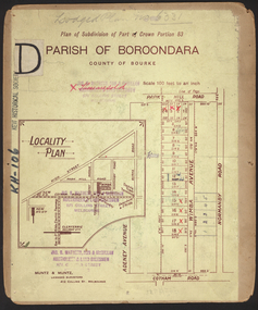
 Kew Historical Society Inc
Plan - Subdivision Plan, Plan of Subdivision of Part of Crown Portion 84 / Parish of Boroondara / County of Bourke / Lodged Plan No. 2217, Twentieth Century
... real estate firm - J. R. Mathers and McMillan, 136 Cotham Road, Kew. The Plans in the collection are rarely in pristine form, being working plans on which the agent would write notes and record lots sold and the prices of these. The subdivision plans are historically significant examples of the growth of urban Melbourne from the beginning of the 20th Century up until the 1980s. A number of the plans are double-sided and often include a photograph on the reverse. A number of the latter are by noted photographers such as J.E. Barnes. Subdivision plans -- Kew (Vic ...Pru Sanderson, in her groundbreaking ‘City of Kew Urban Conservation Study : Volume 2 - Development History’ (1988), summarised the periods of urban development and subdivisions of land in Kew. The periods that she identified included 1845-1880, 1880-1893, 1893-1921, 1921-1933, 1933-1943, and Post-War Development. These periods were selected as they represented periods of rapid growth or decline in urban development. An obvious starting point for Sanderson’s groupings involved population growth and the associated economic cycles. These cycles also highlighted urban expansion onto land that was predominantly rural, although in other cases it represented the decline and breakup of large estates. A number of the plans in the Kew Historical Society’s collection can also be found in other collections, such as those of the State Library of Victoria and the Boroondara Library Service. A number are however unique to the collection.The Kew Historical Society collection includes almost 100 subdivision plans pertaining to suburbs of the City of Melbourne. Most of these are of Kew, Kew East or Studley Park, although a smaller number are plans of Camberwell, Deepdene, Balwyn and Hawthorn. It is believed that the majority of the plans were gifted to the Society by persons connected with the real estate firm - J. R. Mathers and McMillan, 136 Cotham Road, Kew. The Plans in the collection are rarely in pristine form, being working plans on which the agent would write notes and record lots sold and the prices of these. The subdivision plans are historically significant examples of the growth of urban Melbourne from the beginning of the 20th Century up until the 1980s. A number of the plans are double-sided and often include a photograph on the reverse. A number of the latter are by noted photographers such as J.E. Barnes.Undated Plan of Subdivision of Crown Portion 84 in what is now Kew. The area shown is bordered by Burke Road, Harp Road, Arglye Road and Normanby Road.subdivision plans -- kew (vic), harp road, burke road, normanby road, lady loch's drive, gladstone street, second avenue, first avenue -
![Book, A Journey Through Melbourne's East / [by] Fletchers Pty Ltd, 2008](/media/collectors/550653872162f11fb04854aa/items/5d03458521ea7b0950500c7e/item-media/5ebbc47c21ea670348e8dbc7/item-fit-380x285.jpg?cb=6) Kew Historical Society Inc
Kew Historical Society IncBook, A Journey Through Melbourne's East / [by] Fletchers Pty Ltd, 2008
... Kew Historical Society Inc Kew Court House 188 High Street Kew melbourne fletcher & parker (firm) - history. real estate agents - victoria - balwyn north - history melbourne (vic.) - history - pictorial works 127 p. : ill. ...127 p. : ill. (some col.), ports. ; 26 x 26 cm. fletcher & parker (firm) - history., real estate agents - victoria - balwyn north - history, melbourne (vic.) - history - pictorial works -
 Kew Historical Society Inc
Drawing - Property Illustration, Margaret Picken, 22 Wimba Avenue, Kew, 1988
... Kew melbourne This drawing is one of a series created by Margaret Picken for a number of real estate agents in Melbourne between 1983 and 2005. Each work is signed and dated by the artist. The series of drawings in the Picken Collection are invaluable assets for identifying architectural features and styles. The year in which the drawing was created is also a valuable record for house historians, as a number of the properties depicted have either been altered since that date or demolished. artist -- margaret picken 1950- architectural drawings -- houses -- kew (vic.) 22 wimba avenue - kew (vic) 22 WIMBA AVE., KEW / MARGARET PICKEN '88 / WOODARDS ~ KEW Pen and ink architectural drawing on drafting film of 22 Wimba Avenue, Kew by Margaret Picken. 22 Wimba Avenue, Kew Drawing Property Illustration Margaret Picken Woodards (Kew) ...After training as a Cartographic Draftsman within the mining industry, I worked as a property illustrator for real estate firms in the eastern suburbs of Melbourne for 22 years from 1983. I initially photographed houses with a Polaroid camera and made a 'thumbnail' sketch while there. The photos were used to scale off a sketch in pencil and then that sketch was overlaid with drafting film and the 'pen and ink' completed. The pens I used were the Rotring ‘Rapidigraph’ drafting pens. The ink was also made by Rotring (German).The film was ‘Rapidraw’, polyester drafting film, double matte. It takes a very fine line and doesn’t bleed. As well as house sketches, there were often floor plans and site plans ordered. Aerial sketches were ordered when the property needed an overall view. (Margaret Picken, 2020)This drawing is one of a series created by Margaret Picken for a number of real estate agents in Melbourne between 1983 and 2005. Each work is signed and dated by the artist.Gift of Margaret Picken, 2020Pen and ink architectural drawing on drafting film of 22 Wimba Avenue, Kew by Margaret Picken.22 WIMBA AVE., KEW / MARGARET PICKEN '88 / WOODARDS ~ KEWartist -- margaret picken 1950-, architectural drawings -- houses -- kew (vic.), 22 wimba avenue - kew (vic) -
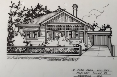 Kew Historical Society Inc
Drawing - Property Illustration, Margaret Picken, 8 Park Crescent, Kew, 1989
... Kew melbourne This drawing is one of a series created by Margaret Picken for real estate agents in Melbourne between 1983 and 2006. Each work is signed and dated by the artist. The drawings in the Picken Collection are invaluable assets for identifying architectural features and styles. The year in which the work was created is also a valuable record for house historians, as a number of the properties depicted have either been altered since that date or demolished. artist -- margaret picken 1950- property illustrations — buildings — kew (vic.) 8 park crescent - kew (vic) 8 PARK CRES., KEW EAST / MARGARET PICKEN '89 / WOODARDS ~ KEW Pen and ink drawing on drafting film of 8 Park Crescent, Kew by Margaret Picken. 8 Park Crescent, Kew Drawing Property Illustration Margaret Picken Woodards (Kew) ...After training as a Cartographic Draftsman within the mining industry, I worked as a property illustrator for real estate firms in the eastern suburbs of Melbourne for 23 years from 1983. I initially photographed houses with a Polaroid camera and made a 'thumbnail' sketch while there. The photos were used to scale off a sketch in pencil and then that sketch was overlaid with drafting film and the 'pen and ink' completed. The pens I used were the Rotring ‘Rapidigraph’ drafting pens. The ink was also made by Rotring (German).The film was ‘Rapidraw’, polyester drafting film, double matte. It takes a very fine line and doesn’t bleed. As well as house sketches, there were often floor plans and site plans ordered. Aerial sketches were ordered when the property needed an overall view. (Margaret Picken, 2020)This drawing is one of a series created by Margaret Picken for real estate agents in Melbourne between 1983 and 2006. Each work is signed and dated by the artist.Gift of Margaret Picken, 2020Pen and ink drawing on drafting film of 8 Park Crescent, Kew by Margaret Picken.8 PARK CRES., KEW EAST / MARGARET PICKEN '89 / WOODARDS ~ KEWartist -- margaret picken 1950-, property illustrations — buildings — kew (vic.), 8 park crescent - kew (vic)