Showing 235 items matching research creek
-
 Marysville & District Historical Society
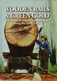
Book - Hardcover book, Peter Evans, Wooden Rails & Green Gold-A century of timber and transport along the Yarra Track, 2022
A history of the timber mills along the Yarra Track from Narbethong to Matlock.Hardcover. Shows Mick Taylor making last-minute adjustments to the rigging of a large log about to commence its journey down the incline to the Marysville Timber and Seasoning Company No.1 mill. Back cover has a photograph of a rail tractor towing a timber trolley along a timber tramway.non-fictionA history of the timber mills along the Yarra Track from Narbethong to Matlock.timber, timber mills, yarra track, narbethong, matlock, marysville, wood's point, wilks creek, great divide, cathedral range, cumberland, foresters, sawmillers, peter evans -
 Marysville & District Historical Society
Book - Hardcover book, Peter Evans, Wooden Rails & Green Gold-A century of timber and transport along the Yarra Track, 2022
A history of the timber mills along the Yarra Track from Narbethong to Matlock.Hardcover. Shows Mick Taylor making last-minute adjustments to the rigging of a large log about to commence its journey down the incline to the Marysville Timber and Seasoning Company No.1 mill. Back cover has a photograph of a rail tractor towing a timber trolley along a timber tramway.non-fictionA history of the timber mills along the Yarra Track from Narbethong to Matlock.timber, timber mills, yarra track, narbethong, matlock, marysville, wood's point, wilks creek, great divide, cathedral range, cumberland, foresters, sawmillers, peter evans -
 Kiewa Valley Historical Society
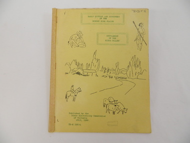
Book - Bogong High Plains x2, Early History and Discovery of the Bogong High Plains, 1968
The State Electricity Commission of Victoria constructed the Kiewa Hydro Electric Scheme in the north east of Victoria. Mr R.M. Duncan prepared the notes. He was a member of the S.E.C. Kiewa Branch from 1949 - 1966. This book was commissioned by the State Electricity Commission of Victoria. It consists of the early history of the Bogong High Plains and the origin of names of places and creeks in the area.This book was researched in 1968 by Mr R.M. Duncan who worked for the S.E.C. on the Kiewa Hydro Electric Scheme from 1949 to 1966. His sources were the Melbourne Public Library, the Victorian Historical Society, the North Eastern Victorian Historical Society and the Dept. of Crown Lands & Survey, Melbourne. The book is an accurate history of the Bogong High Plains given the available records at the time. Yellow cardboard covered book with black sketches and green print. 9 one-sided pages held together by 3 staples and taped over the staples. One - has sheets enclosed "The Three Floras of Bogong" and "General Geology of the Kiewa Area". 6 copies including 1 that is a photocopyDDTS hand written on front cover "Early History and Discovery / of the / Bogong High Plains" on cover top centre. "Settlement / of the / Kiewa-Valley" on cover towards the top slightly to the right. "Published by the / State Electricity Commission / of Victoria / July, 1968" on cover bottom left. "TR-K 596-4" on cover bottom left.bogong high plains. state electricity commission of victoria. kiewa. aborigines. kiewa valley. mullindollingong pastoral run. flora. geology -
 Kiewa Valley Historical Society
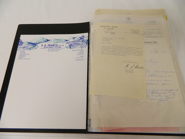
Folder - Retail Development of Mt Beauty
The papers have been collected in correspondence since 1947 and cover many of the retail shops in Mt Beauty. The sale of the shops by the State Electricity Commission during the 1960's when the construction of the Kiewa Hydro Electric Scheme was completed. Owners of the Mt Beauty Supermart and Newsagency and Falls Creek Mini-Mart, Samuel Keith Pearce and Gordon Cathew Pearce's documents are included. The papers record a period when the SECV sold the retail shops in Mt Beauty after the completion of the Kiewa Hydro Electric Scheme. This enables researchers to gauge the value of the properties at the time and the changes in retail shops from that time.A black plastic folder containing a collection of correspondence pertaining to the retail development of Mt Beauty from the 1940's through to the 1960's and 1970's. pearce bros. mt beauty. falls creek. mt beauty retail. state electricity commission of victoria. -
 Kiewa Valley Historical Society
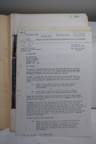
West Kiewa Alpine Way and Day Ski Resort
In June 1982 This research report on the West Kiewa Alpine Way Proposal was sent to the Mt Beauty Chamber of Commerce. "The economic, tourist market and geographic factors are the kernel of the proposal." From Industrial Relocations Consultants Pty. Ltd.The proposal was to benefit the tourism industry.Manila foolscap folder with metal fastener. Papers dated June 1982 re - "Proposed West Kiewa Alpine Way and Day Ski Resort" Also enclosed but not related: Letter from Falls Creek Tourist Area Management Committee July 1984B. Goss written on coverwest kiewa alpine way, day ski resort, mt beauty chamber of commerce -
 Kiewa Valley Historical Society
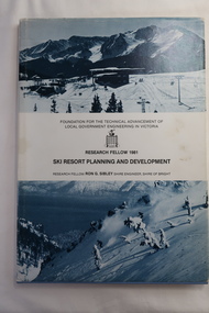
Book - Ski Resort Planning and Development, Ski Resort Planning and Development by Research Fellow Ron G. Sibley Shire Engineer, Shire of Bright
This book was published in 1981 when the Ski Industry and the Shire of Bright were proposing to expand the tourism industry.Of interest to Local Government and to those involved in the development of and activities carried out in Alpine country and ski resort areas. This research identifies the advantages and possibilities for the future.Hard light blue plain cover book with paper cover and bound spine. The paper cover has a snow photo (bluish) above and below the title. 113 pages with black and white photos and diagrams.Front page has "B.H.Goss / 37 Roper St., / Mt. Beauty 3699" stamped in top right corner.ski resort planning, ski resort development, falls creek's future, shire of bright -
 Ringwood and District Historical Society
Photographs, 1979-80 MMBW pipe line project at Hubbard Reserve, North Ringwood � Track down to creek bridge
Part of a 43-photo record of the MMBW�s engineering feat in drilling a 12 inch pipe line up to 40 feet deep through rock hardened by volcanic action associated with geological fault that occurs along the line. The work took place from October 1979 to May 1980 on the southern boundary of Hubbard Reserve, North Ringwood. The collection was presented to the Ringwood Historical Research Group by J Clarke on 9th June 1980.E565 N12 13 May 1980 A43 My old track down to the bridge over the creek. The pipe line went to the right of the big tree 40-foot down. -
 Ringwood and District Historical Society
Photographs, 1979-80 MMBW pipe line project at Hubbard Reserve, North Ringwood � The manhole in the creek
Part of a 43-photo record of the MMBW�s engineering feat in drilling a 12 inch pipe line up to 40 feet deep through rock hardened by volcanic action associated with geological fault that occurs along the line. The work took place from October 1979 to May 1980 on the southern boundary of Hubbard Reserve, North Ringwood. The collection was presented to the Ringwood Historical Research Group by J Clarke on 9th June 1980.E563 1 April 1980 A43 The manhole in the creek, waiting until boring is finished. -
 Ringwood and District Historical Society
Photographs, 1979-80 MMBW pipe line project at Hubbard Reserve, North Ringwood � View towards Debbie Place
Part of a 43-photo record of the MMBW�s engineering feat in drilling a 12 inch pipe line up to 40 feet deep through rock hardened by volcanic action associated with geological fault that occurs along the line. The work took place from October 1979 to May 1980 on the southern boundary of Hubbard Reserve, North Ringwood. The collection was presented to the Ringwood Historical Research Group by J Clarke on 9th June 1980.E561 N15 3 March 1980 A43 View towards Debbie Place, showing 2 swivel cranes at shafts, timber of manhole in creek, the tracked drill rig and its compressor caravan. -
 Orbost & District Historical Society
register, Register of Residence Areas, 10.2.1897 - 4.9.1934
This book is a register of land holders with miners' rights. The correspondence is associated with applications for miners' rights on privately owned land and business sites. They include application fotrms and objections to registrations. The areas referred to are Combienbar, Goongerah, Club Terrace, Wombat Creek and Dundong. One of the privileges under the Mines Act, conferred by the holding of a miner's right until 1935 was that of residence on up to one acre on a gold-fields area. Those occupying a residence area were "deemed in law to be possessed ... of such ... parcels ... and the property therein".This is a useful research tool.A large, heavy book with a grey cloth cover and red spine. The end papers are marbled. The inside pages are ruled in grey with red ruled columns. Entries are hand-written. There are copies of correspondence inside. Details given are the registration number and date, the name of the person, the number of the miner's right and its date, a description of the allotment and any remarks or references to other volumes. Any changes of ownership are shown. The book is mostly unused.register-mining miners-rights -
 Orbost & District Historical Society
Book - front cover, The Corringle Creek to Sydenham Inlet Coastal Reserve A RESOURCES STUDY, 1977
This 1977 Resources Study was a joint project of the Shire of Orbost & the Dept. of Crown Lands & Survey with the purpose of collating information on natural resources, pattern of public use, and constraints on future use so that management can be formulated.This report gives and understanding of the resources and management directions of coastal land in East Gippsland in 1977. A buff coloured cover with black printing and blue tape binding. 71 pages + maps/charts. THE CORRINGLE CREEK TO SYDENHAM INLET COASTAL RESERVE. A resources study with comment on the implications for management by IAN R. BROWN Research officer and PETER B. LAVERY Land Management Oficer. Coastal management Committee Victoria 1977. Published under the authority of the Coastal Management Committee by the Department of Crown Lands and Survey, Victoria 1977. Printed by James Yeates Printing, Bairnsdale 3875.corringle creek, sydenham inlet, natural resources survey -
 The Beechworth Burke Museum
Photograph, 1920-1950
This image taken between 1920-1930 depicts open-cut hydraulic sluicing at the Three Mile Mine, located about five kilometres south of Beechworth. Alluvial, or surface, mining began on this site in the 1850s, but was soon replaced by hydraulic sluicing methods. By the start of 1880 it is estimated that nine hundred miles of water races had been cut though soil and rock in the Beechworth district. Hydraulic sluicing employs high pressure jets of water to blast away large areas of earth and wash it down to be run through a sluice box. Gold gets caught in the sluice and the remaining slurry is washed away. Large water quantities were required for hydraulic sluicing, and the long water races and deep tailraces that were constructed were considered great engineering feats. This method of mining is extremely effective, but causes significant environmental damage and impacts to waterways and agricultural operations. Miners at Beechworth built extensive networks of races and dams to secure reliable supplies of water on a scale far greater than elsewhere in Victoria. By the 1880s Beechworth's water barons continued to hold more than half of all the water right licences on issue and undertook sluicing operations on a massive scale. The manipulation of surface and ground water via race networks was well planned and recorded in detail by local mining surveyors. The maps that were created, combined with modern geo-spatial technologies, provide a vital key in understanding the great lengths to which miners went to capture and control critical water resources. Today, Three Mile mine is called Baarmutha. The Three Mile Mine was unproductive until 1865 when John Pund and three other miners secured a fifteen year license and constructed a water race from Upper Nine Mile Creek to Three Mile Creek. In the early twentieth century Pund & Co. averaged over one thousand ounces of gold per year from the mine. After Pund's death in 1915, GSG Amalgamated Co operated the site, continuing sluicing until 1950. This image of hydraulic sluicing methods shows the extent of water-works engineering in the landscape. This photograph has historic and research potential for understanding changes to the landscape, the evolution of mining methods, and the extensive construction, manipulation and management of water networks in the Beechworth district. Black and white rectangular photograph on matte paperReverse: 7597-1 / Sluice Mining / Copied from original on loan from Webb (Qld) / Donated Nov 2009 / Baarmutha Three Mile Mine c1920-1950 / Managed by the Plain Bros then Parkinsons / Current Location is: Beechworth Animal Shelter / used for Baarmuthaburke museum, beechworth museum, beechworth, gold fields, gold rush, victorian gold rush, hydraulic sluicing, spring creek, netwown falls, mining tunnels, water races, tailraces, gold ming history, colonial australia, australian gold rushes, mining technology, beechworth historic district, indigo gold trail, indigo shire, john pund, water manipulation, water engineering, three mile creek, three mile mine, water race, large-scale mining methods, historical mining construction, alluvial mining, mining environmental impacts, baarmutha, water barons -
 The Beechworth Burke Museum
Postcard, George Symons, c.1990
The photograph printed on this postcard comes from the collection of the Mitchell Library in Sydney. It is sepia in tone and depicts seven men standing and sitting around a mine shaft in the Beechworth region. The photograph has been dated to approximately 1872. This period in history post-dates the Victorian gold rushes which occurred 1852-1853 in Ballarat, Bendigo and Beechworth. During this period, in the 1870s, the surface alluvial gold had been discovered and removed from location. Therefore, in order to reach the deeper and less accessible alluvial gold, diggers began to dig shafts into the earth. These shafts sunk below the ground level by 20 to 30 feet and required timber structures around the entrance and winches to bring the paydirt to the top. The top of this wooden structure is visible behind the man standing in the upper right of the image. This type of mining was highly dangerous as mines often caved in which injured the minors and often resulted in death. Thus, following this period, in the early 1900s, miners opted instead for hydrolic slucing which cut away the earth without the devastating consequences of a mine cave in. This particular group of miners appear to have been unable to afford a horse (then worth around 50 pounds) which were generally used at mines like this to help pull buckets attached to ropes up and down the mine. Instead, this group brought the buckets up and down by windlass. The windlass was a wooden structure mounted over the mining shaft and fitted with a hand-cranked winch which enabled the bucket attached to the rope to be brought up and down.Gold was first discovered in Beechworth in Spring and Reid's Creek in the summer of 1852-1853. At its popularity, this region had approximately 8000 people on the gold fields searching for gold on the banks of these creeks. These periods did not require the use of heavy machinery or the digging of deep mining shafts like the one depicted in this image. Therefore, this image has important connotations for the technologies associated with mining during the approximated 1870s when gold was harder to access. This is a later period in gold history which does not fit into the "gold rush" period. Instead, it occurred after the surface gold had disappeared and therefore, is essential for researchers who are investigating the mining techniques and structures used to reach the alluvial gold which was located deeper under ground in the 1870s. This period predates the use of big heavy machinery used to mine in the 1900s which include dredges. Images such as this one can also impart essential information as to the wardrobe and fashion of men during this period. It also imparts knowledge about the landscape of Beechworth which is useful for people researching the environment and impact of gold mining in the north-east region of Victoria. In addition, since this image is a postcard reproduction of an early Australian image which may date to approximately 1990 it can impart knowledge as to the interests of people during this time period when there may have been an increase into Australian history.A sepia tone facsimile of an early Australian photograph (circa 1872) printed as a postcard.Obverse: BEECHWORTH / Victoria, Australia / Reverse: GM 2 3275 / CORRESPONDENCE / AUSTRALIAN / YESTERYEAR / CARDS / ADDRESS / Published by George Symons (057) 65 3240 / THE MINEHEAD C. 1872 / The easily gleaned gold of the early fields did / not last very long. In order to reach less / accessible alluvial gold diggers began sinking shafts as much as twenty to thirty feet down / and the mines required timbering and winches / to bring the paydirt to the top. / This syndicate has been unable to afford the / luxury of a horse (about 50 pounds) and so everything / must go up and down by windlass and rawhide / bucket. / Photo: Mitchell Library, Sydney / A sepia tone facsimile of / an early Australian photographmining album, gold mine, beechworth, burke museum, mine shaft, postcard, australian yesteryear cards, george symons, the minehead, gold fields, alluvial gold, early australia, c.1872, 1872, gold diggers, north east victoria -
 The Beechworth Burke Museum
Photograph - Photograph - Reproduction, W. D. Gibbon, Early 1900s
This photograph was taken in 1911 at Three Mile Creek, about five kilometers south of Beechworth town. Significant digging took place at this location from late 1855, which led to a flood of workers and stores to follow, though daily earnings were slim compared to the nearby Woolshed site. This remained the case even after workers at Three Mile Creek attempted to protest around Beechworth during an election in November 1855. Three Mile Creek was one of seven significant divisions of the Beechworth Mining District formalised by the Governor-in-Council in 1858, though by the time this photograph was taken, the boundaries of the original seven districts had shifted to create seventeen divisions. The Three Mile Goldfields was a site of rich alluvial gold deposits located about 5km south of Beechworth in Victoria. Today, the location of this gold deposit is called Baarmutha. It was a popular area for gold mining in the 1850s but became largely abandoned by the following decade. In 1865, a man named John Pund (a man second from the left in the back row of this photograph shares this surname) recognized that the area could be potentially rich if a better water supply could be obtained. He secured a 15 year license with three other miners. Within the next five years, these men had constructed 19 km of water race going from Upper Nine Mile Creek to Three Mile Creek. By 1881, these four men had delivered 950,000 gallons to the Three Mile Sluicing area which is depicted in this photograph. Pund would later go into partnership with John Alston Wallace who would become owner of the Star Hotel in Beechworth. The Three Mile sluicing location continued to be operational until 1950. The eleven miners in this photograph are: Back row: Led Guthrie, P. Pund, F. Beel, [Unknown] Miller Front row: Paddy McNamara, J. King, W. Beel, [Unknown] Garland, J. Clarke, J. Ryan, H. Bartsh In the background of the photograph is a huge dirt wall that appears to suffer damage caused by hydraulic sluicing. Hydraulic sluicing is a specialised mining technique that involves directing high pressure water flows at dirt to uncover gold. The technique played a significant role in shaping Beechworth's landscape during the gold rush to create the topography seen today.The search for gold is ingrained into the history of Victoria and therefore, images like this one which portray an open cut sluicing site can reveal important information for society and technology for the date when the photograph was taken. This image is of important historical significance for its ability to convey information about sluicing and the methods used to find gold in the late 1800s and early 1900s. It also shows a location where sluicing was undertook which provides insight into the impact of sluicing on the environment at a time when it was done. Images, like this one, of Australian gold rush history can reveal important information about the social and environmental impact of this period. This image depicts diggers standing in a mining location and therefore, this image has the capacity to reveal or support significant information for researchers studying the fashion and social status of diggers in Australia in approximately 1911. It can also provide information on the landscape of Australia in this period and the impact of mining for gold on both society and the Australian landscape. The Burke Museum is home to a substantial collection of Australian mining photographs which can be used to gain a deeper understanding into life on the gold fields, technology used in mining, the miners themselves and the impact of the gold digging on the environment.Black and white / sepia rectangular reproduced photograph printed on glossy photographic paper mounted on board.beechworth, beechworth museum, mining, mining team, three mile creek, sluicing, hydraulic sluicing, photography, gold sluicing, gold mining, pund mining -
 Eltham District Historical Society Inc
Photograph, Tom Prior, A pretty spot, Lac's Creek near Main Road
Originally the Storey family lived there followed by the Lacs (shoemaker).The Reynolds family were early settlers in Research. The Reynolds/ Prior collection of photographs were taken by Tom Prior, the maternal uncle of Ivy Reynolds, around 1900 and the 60 photos in the album give a fine overview of many of the landmarks of Research and Eltham over 100 years ago. lvy lived in the family home for many years at 106 Thompson Cres Research. Ivy's father, Ernst Richard Reynolds and grandfather, Richard Reynolds, lived at the same address. Ivy's father Richard worked for Mr. Trail on his property in Research. Reynolds Road is named after the family. Mr Tom Prior (wife Eva) worked at the Melbourne zoo. He was very innovative and made his own camera, using the black cloth hood to exclude the light. The photographs are a reminder of the rural nature of Research and Eltham and its rich heritage. Black and white photograph mounted in an album, the Reynolds/Prior Photograph Collection, this being one of 53 reproduced black and white images of early Eltham.The Reynolds/Prior Photograph Collection, Presented to the Eltham District Historical Society, 14 June 2006 by Ross McDonald. A second copy was also presented to the Andrew Ross Museum, Kangaroo Groundcreek, lac family, lac's creek, reynolds prior collection, storey family -
 Eltham District Historical Society Inc
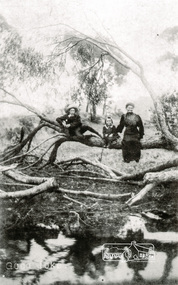
Photograph, Tom Prior, Family photo by creek
Shows Ivy Reynolds' maternal grandmotherThe Reynolds family were early settlers in Research. The Reynolds/ Prior collection of photographs were taken by Tom Prior, the maternal uncle of Ivy Reynolds, around 1900 and the 60 photos in the album give a fine overview of many of the landmarks of Research and Eltham over 100 years ago. lvy lived in the family home for many years at 106 Thompson Cres Research. Ivy's father, Ernst Richard Reynolds and grandfather, Richard Reynolds, lived at the same address. Ivy's father Richard worked for Mr. Trail on his property in Research. Reynolds Road is named after the family. Mr Tom Prior (wife Eva) worked at the Melbourne zoo. He was very innovative and made his own camera, using the black cloth hood to exclude the light. The photographs are a reminder of the rural nature of Research and Eltham and its rich heritage. Black and white photograph mounted in an album, the Reynolds/Prior Photograph Collection, this being one of 53 reproduced black and white images of early Eltham.The Reynolds/Prior Photograph Collection, Presented to the Eltham District Historical Society, 14 June 2006 by Ross McDonald. A second copy was also presented to the Andrew Ross Museum, Kangaroo Groundreynolds prior collection, eltham, creek -
 Eltham District Historical Society Inc
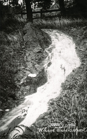
Photograph, Tom Prior, Where water's sport
Labelled by Ivy Reynolds' mother who had a good sense of humour.The Reynolds family were early settlers in Research. The Reynolds/ Prior collection of photographs were taken by Tom Prior, the maternal uncle of Ivy Reynolds, around 1900 and the 60 photos in the album give a fine overview of many of the landmarks of Research and Eltham over 100 years ago. lvy lived in the family home for many years at 106 Thompson Cres Research. Ivy's father, Ernst Richard Reynolds and grandfather, Richard Reynolds, lived at the same address. Ivy's father Richard worked for Mr. Trail on his property in Research. Reynolds Road is named after the family. Mr Tom Prior (wife Eva) worked at the Melbourne zoo. He was very innovative and made his own camera, using the black cloth hood to exclude the light. The photographs are a reminder of the rural nature of Research and Eltham and its rich heritage. Black and white photograph mounted in an album, the Reynolds/Prior Photograph Collection, this being one of 53 reproduced black and white images of early Eltham.The Reynolds/Prior Photograph Collection, Presented to the Eltham District Historical Society, 14 June 2006 by Ross McDonald. A second copy was also presented to the Andrew Ross Museum, Kangaroo Groundreynolds prior collection, creek -
 Eltham District Historical Society Inc
Photograph, Memorial Tower, Kangaroo Ground c.1934, 1934c
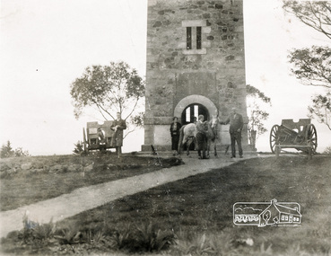
Sepia photograph of Joyce McMahon and 'Tiny' Carroll at the War Memorial Tower, Kangaroo Ground c.1934. The guns were installed in 1934 and removed in 1942. Taken in the early 1930s, the photograph ... shows the Kangaroo Ground Tower of Remembance with Joyce McMahon, daughter-in-law of Mr. P. J.McMahon, the then Shire of Eltham Secretary, her horse and a very tall person patting the horse. He is ex-serviceman W. "Tiny" Caroll who was the council's caretaker of the surrounding War Memorial Park. He lived in the stone cottage which still stands in the park. "Tiny" is seen as the fictional character "Tiny Bourke" who, in author Alan Marshall's book "This is the Grass", "was a giant of a man, well over six feet high, with huge hands that completely encircled the cup of tea". The bronze casting, which shows the 79 names of those who paid the "supremen sacrifice" in World War 1 (1914-1918), was erecfed above the entrance to the Tower in September, 1930. The Monterey cypress trees which now form the windbreak around the park's fenceline, were just knee high in this photograph. They were planted in August 1926, with all the plantings paid for, and done, by the public as the Tower was being erected. The two field guns have been identified as of German origin, Krupp 77 mm calibre captured on October 4, 1918 at Geneve, France. They were removed in 1943/44 as a wartime requirement of the Australian Govenment. A public notice dated October 16, 1926 by Cr. H Rutter, Chairman of the Eltham Soldiers War Memorial League stated: "On the summit of that central and conspicuous landmark, Garden Hill, there is being erected a massive memorial tower which will, for all time, remind every passerby of the part played by the men of the Shire of Eltham in the Great War. The work has been undertaken by the people of the Shire a a tribute of love and admiration for those who were known and dear to use in the days of their youth and early manhood, who went out from amongst us, never to return, and whose self-sacrifice has made us, each and all, thier ever-lasting debtors" Harry Gilham, Eltham District Historical Society Kangaroo Ground Tower of Remembrance, A Journey in Time: a column about Nillumbik's history, Nillumbik Mail, 9th August, 2000 Since that research the following has been sourced from Eltham and Whittlesea Shires Advertiser and Diamond Creek Valley Advocate, April 8, 1921, p. 3 Retrieved April 25, 2020, from http://nla.gov.au/nla.news-article57639687 Eltham Shire Council From Town Clerk, Melbourne, stating that a light machine-gun captured by the 22nd battalion, A.I.F. at La Motte Farm, near Beaurvoir, on Oct. 3rd, 1918, during the operations which won the Beauvoir line and completed the smashing of the great Hindenburg defence-system, has been alloted to the Shire of Eltham. - On the motion of Crs Hubbard and Smedley, it was decided to have the gun placed in the Memorial Park. Sepia Photographgarden hill, gun, joyce mcmahon, kangaroo ground, memorial tower, shire of eltham war memorial tower, tiny carroll, war memorials, war trophy, william carroll -
 Eltham District Historical Society Inc
Folder, Mr Grimshaw, Miner, Kinglake and Caledonian Diggings
We have three folders catalogued for the Grimshaw name and these will in due course be consolidated/corrected: 1. EDHS_01361 – A.H. Grimshaw of Research, Vic., 1927 2. EDHS_01362 – John Grimshaw of Greensborough, 1862 (Correct name is Josiah Grimshaw) 3. EDHS_01375 – Mr Grimshaw, miner of Kinglake and Caledonian Diggings. (This is believed to be Mr J.L. (Jack) Grimshaw who reportedly discovered the first gold in Kinglake. These folders are made up of copies of pages of research undertaken by Mr Keith Chappel in the 1970s, which is now catalogued as a separate item. EDHS_04448 - Eltham District History, Eltham Road Board, 1856-1871; Research by Keith Chappel https://victoriancollections.net.au/items/5e4a290521ea671e9ccf9661 There is further information from this research concerning a William Grimshaw. Also included as part of EDHS_01375 is a photocopy of page44 from the book "Caledonia Diggings (St Andrews)", Gold Discovery in Victoria, James Flett, 1970, which references No. 2 Creek at the Caledonian Diggings as also been known as Grimshaws. We have a photo of J.L.(Jack) Grimshaw who discovered gold at Kinglake, which is part of the Shire of Eltham Pioneers Photograph Collection (SEPP) SEPP_0056 - Mr. J.L. Grimshaw; the man who found the first gold at Kinglake https://victoriancollections.net.au/items/5a6c158721ea6906ac29bd3c We also have another record of interest involving Aaron Grimshaw, Farmer of Greensborough who was an indentured Trustee of the Wesleyan Chapel in Little Eltham in 1856: EDHS_04610-3-1 - Document, Conveyance of Lot 20 Henry Street, Little Eltham North to Trustees of Wesleyan Chapel, 1856 https://victoriancollections.net.au/items/60f6d644ac5d4de270b83615 The record of Joshia Grimshaw of Greensborough is grim. He was arrested and charged with the murder of John Mitchell at Greensborough, September 24, 1962. Grimshaw was ultimately convicted of manslaughter and sentenced for three years in prison. Newspaper reports of the day show his name as Josiah. Whether he was also known as John is not clear, and whether he is the same as J.L. (Jack) Grimshaw who discovered gold at Kinglake, again is unclear without undertaking further research into the matter. This murder trial was extensively reported in the newspapers and you can find those reports on the National Library of Australia’s Trove https://trove.nla.gov.au/ Some of the reports of interest: TRIAL OF GRIMSHAW FOR MURDER (1862, October 23). The Kyneton Observer (Vic. : 1856 - 1900), p. 3. Retrieved April 21, 2023, from http://nla.gov.au/nla.news-article240899299 THE GREENSBOROUGH MURDER. (1862, September 30). The Argus (Melbourne, Vic. : 1848 - 1957), p. 6. Retrieved April 21, 2023, from http://nla.gov.au/nla.news-article5722929 MELBOURNE CRIMINAL SESSIONS. (1862, October 18). The Age (Melbourne, Vic. : 1854 - 1954), p. 6. Retrieved April 21, 2023, from http://nla.gov.au/nla.news-article154967162 CRIMINAL SESSIONS. I (1862, October 18). The Argus (Melbourne, Vic. : 1848 - 1957), p. 6. Retrieved April 21, 2023, from http://nla.gov.au/nla.news-article6480408 Folder of information on Mr Grimshaw, Miner, Kinglake and Caledonian Diggingsgrimshaw -
 Warrnambool and District Historical Society Inc.
Map - Fire Maps, Region 5 Fire Control Map, 1963
Two fire maps of south west Victoria.1 This is a rectangular piece of linen folded several times to form a packet with the front part covered with a brown card. The cover has a blue and white label. The map has a white base with red and green markings and red and black printing .2 As .1 abovenon-fictionTwo fire maps of south west Victoriafire maps, warrnambool history -
 Kew Historical Society Inc
Book, Geoff Hocking, Castlemaine : from camp to city 1835-1900, a pictorial history of Forest Creek & the Mount Alexander goldfields, 1994
230 p. : ill. (some col.), facsims, maps, ports. ; 22 x 25 cm.non-fictiongold mines and mining -- victoria -- castlemaine -- history, castlemaine (vic.) -- history -
Kew Historical Society Inc
Journal, Kew Historical Society, Newsletter No.132, September 2020
There once was a creek [Connors Creek] / Julie King p1. History news [Coronavirus (COVID-19), Michael Tuck grandstand, grants,] p3. The men who bought Kew: the Fenwicks and Edward Bell / David White p4. The Henty Garden at Tarring: Ruyton Girls’ School / Felicity Renowden p6. Paddocks, parks and bye-laws: regulating behaviours by and within municipalities / Robert Baker p8. A significant donation [Margaret Picken’s property illustrations] / Robert Baker p10. From the collection [North Indian scarf embroidered with a needle] / Robert Baker p10. The albums of Eva Grant: photographs and descriptions of historic houses / Robert Baker p11.Published quarterly since 1977, the newsletters of the Kew Historical Society contain significant research by members exploring relevant aspects of the Victorian and Australian Framework of Historical Themes. Frequently, articles on people, places and artefacts are the only source of information about an aspect of Kew, and Melbourne’s history.non-fictionThere once was a creek [Connors Creek] / Julie King p1. History news [Coronavirus (COVID-19), Michael Tuck grandstand, grants,] p3. The men who bought Kew: the Fenwicks and Edward Bell / David White p4. The Henty Garden at Tarring: Ruyton Girls’ School / Felicity Renowden p6. Paddocks, parks and bye-laws: regulating behaviours by and within municipalities / Robert Baker p8. A significant donation [Margaret Picken’s property illustrations] / Robert Baker p10. From the collection [North Indian scarf embroidered with a needle] / Robert Baker p10. The albums of Eva Grant: photographs and descriptions of historic houses / Robert Baker p11.kew historical society (vic.) -- periodicals., kew historical society (vic.) -- newsletters, kew historical society (vic.) -- journals -
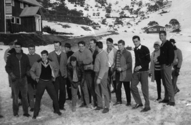 Slovenian Association Melbourne
Falls Creek, photo, Slovenians at Falls Creek, 1965
... Slovenian Association Melbourne 82 Ingrams Road Research ... -
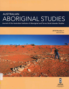 Victorian Aboriginal Corporation for Languages
Periodical, Australian Institute of Aboriginal and Torres Strait Islander Studies, Australian Aboriginal studies : journal of the Australian Institute of Aboriginal and Torres Strait Islander Studies, 2010
Mediating conflict in the age of Native Title Peter Sutton (The University of Adelaide and South Australian Museum) Mediators have played roles in managing conflict in Aboriginal societies for a long time. This paper discusses some of the similarities and differences between older customary mediator roles and those of the modern Native Title process. Determinants of tribunal outcomes for Indigenous footballers Neil Brewer, Carla Welsh and Jenny Williams (School of Psychology, Flinders University) This paper reports on a study that examined whether football tribunal members? judgments concerning players? alleged misdemeanours on the sporting field are likely to be shaped by extra-evidential factors that disadvantage players from Indigenous backgrounds. Indigenous and non-Indigenous Australian Football League (AFL) players, matched in terms of their typical levels of confidence and demeanour in public situations, were interrogated in a mock tribunal hearing about a hypothetical incident on the football field. The specific aim was to determine if the pressures of such questioning elicited behavioural differences likely to be interpreted as indicative of testimonial unreliability. Mock tribunal members (number = 103) then made judgments about the degree to which a number of behavioural characteristics were evident in the players? testimonies. Under intense interrogation, Indigenous players were judged as presenting less confidently and displaying a greater degree of gaze aversion than non-Indigenous players. These behavioural characteristics are commonly ? and inappropriately ? used as cues or heuristics to infer testimonial accuracy. The paper discusses the implications for Indigenous players appearing at tribunal hearings ? and for the justice system more broadly. Timothy Korkanoon: A child artist at the Merri Creek Baptist Aboriginal School, Melbourne, Victoria, 1846?47 ? a new interpretation of his life and work Ian D Clark (School of Business, University of Ballarat) This paper is concerned with the Coranderrk Aboriginal artist Timothy Korkanoon. Research has uncovered more about his life before he settled at the Coranderrk station in 1863. Evidence is provided that five sketches acquired by George Augustus Robinson, the former Chief Protector of Aborigines, in November 1851 in Melbourne, and found in his papers in the State Library of New South Wales, may also be attributed to the work of the young Korkanoon when he was a student at the Merri Creek Baptist Aboriginal School from 1846 to 1847. Developing a database for Australian Indigenous kinship terminology: The AustKin project Laurent Dousset (CREDO, and CNRS, Ecole des Hautes Etudes en Sciences Sociales), Rachel Hendery (The Australian National University), Claire Bowern (Yale University), Harold Koch (The Australian National University) and Patrick McConvell (The Australian National University) In order to make Australian Indigenous kinship vocabulary from hundreds of sources comparable, searchable and accessible for research and community purposes, we have developed a database that collates these resources. The creation of such a database brings with it technical, theoretical and practical challenges, some of which also apply to other research projects that collect and compare large amounts of Australian language data, and some of which apply to any database project in the humanities or social sciences. Our project has sought to overcome these challenges by adopting a modular, object-oriented, incremental programming approach, by keeping metadata, data and analysis sharply distinguished, and through ongoing consultation between programmers, linguists and communities. In this paper we report on the challenges and solutions we have come across and the lessons that can be drawn from our experience for other social science database projects, particularly in Australia. A time for change? Indigenous heritage values and management practice in the Coorong and Lower Murray Lakes region, South Australia Lynley A Wallis (Aboriginal Environments Research Centre, The University of Queensland) and Alice C Gorman (Department of Archaeology, Flinders University) The Coorong and Lower Murray Lakes in South Australia have long been recognised under the Ramsar Convention for their natural heritage values. Less well known is the fact that this area also has high social and cultural values, encompassing the traditional lands and waters (ruwe) of the Ngarrindjeri Nation. This unique ecosystem is currently teetering on the verge of collapse, a situation arguably brought about by prolonged drought after decades of unsustainable management practices. While at the federal level there have been moves to better integrate typically disparate ?cultural? and ?natural? heritage management regimes ? thereby supporting Indigenous groups in their attempts to gain a greater voice in how their traditional country is managed ? the distance has not yet been bridged in the Coorong. Here, current management planning continues to emphasise natural heritage values, with limited practical integration of cultural values or Ngarrindjeri viewpoints. As the future of the Coorong and Lower Murray Lakes is being debated, we suggest decision makers would do well to look to the Ngarrindjeri for guidance on the integration of natural and cultural values in management regimes as a vital step towards securing the long-term ecological viability of this iconic part of Australia. Hearts and minds: Evolving understandings of chronic cardiovascular disease in Aboriginal and Torres Strait Islander populations Ernest Hunter (Queensland Health and James Cook University) Using the experience and reflections of a non-Indigenous clinician and researcher, Randolph Spargo, who has worked in remote Aboriginal Australia for more than 40 years, this paper tracks how those at the clinical coal-face thought and responded as cardiovascular and other chronic diseases emerged as new health concerns in the 1970s to become major contributors to the burden of excess ill health across Indigenous Australia. The paper cites research evidence that informed prevailing paradigms drawing primarily on work in which the clinician participated, which was undertaken in the remote Kimberley region in the north of Western Australia. Two reports, one relating to the Narcoonie quarry in the Strzelecki Desert and the other concerning problematic alcohol use in urban settings.maps, b&w photographs, colour photographs, tablesstrzelecki desert, native title, timothy korkanoon, merri creek baptist aboriginal school, austkin project, coorong, lower murray lakes district, south australia, indigenous health -
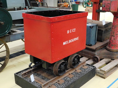 Puffing Billy Railway
Benwerrin Coal Company Coal Skip, circa 1899 - 1904
BENWERRIN COAL COMPANY SKIP This quarter ton coal truck or skip was used at a small mine situated at Benwerrin near Deans Marsh in Victoria’s Otway Ranges. The mine first opened in 1899 and closed in 1904. With the fuel shortages due to World War 2, the Benwerrin Coal Company reopened the mine in 1941. The coal was loaded into skips and winched out of Box’s Creek valley on a narrow gauge incline to a loading point that was close to the Deans Marsh-Lorne Road. It was then taken by road to the Deans Marsh Railway station. The average gradient of the tramway was 1 in 4 over a length of just under 500 metres (1600 feet). The gauge of the tramway has often been referred to as 375mm (or 15 inches) as shown on the map opposite taken from “Sawdust and Steam”. However, actual measurements of the wheels show the gauge to be 400mm (or 16 inches), which is quite unusual as is the small size of the skip itself. The mine produced up to 30 tonnes of brown coal each week until it closed in 1949 and the incline tramway and its skips were abandoned. Preservation of this coal truck came as a result of interest by the Tramway Museum Society of Victoria (TMSV) in the Barlow or Box type rails that it ran on. These rails had originally come from the Beaumaris Horse Tramway and were obtained by the Benwerrin Coal Company from Hayden Bros’ abandoned timber tramway at nearby Barwon Downs. Members of the TMSV visited the mine in the 1960s only to find that most of the tramway had recently been recovered for scrap. There remained a significant number of relics around the mine adits including most of the skips. One of these remained in good condition and it was recovered for preservation in May 1967. It was restored but never displayed and a second restoration took place by the author over 2012/13 so that it could be placed in the Menzies Creek Museum where it was delivered in February 2013. Little remains of the mine today with trestles and sleepers destroyed in the “Ash Wednesday” Bushfires in 1983. References: Houghton, N (1975), Sawdust and Steam, Light Railway Research Society of Australia. Historic - Industrial Narrow Gauge Railway - Benwerrin Coal Company , Benwerrin , Victoria, AustraliaCoal Skip - made of Iron sheet and wrought iron frame & wheelsB,C.Co Melbournepuffing billy, coal skip, benwerrin coal company, narrow gauge -
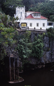 Robin Boyd Foundation
Slide, Robin Boyd, 1966
Robin Boyd was appointed Exhibits Architect for the Australian Pavilion at Expo ‘67 in Montreal. In 1966 Boyd travelled to Far North Queensland and the Northern Territory for research – the Expo exhibits included a coral display and native plant garden.Colour slide in a mount. Paronella Park, Mena Creek, outside Innisfail, Queensland, AustraliaMade in Australia / 10 / DEC 66 M8queensland, slide -
Hume City Civic Collection
Book, Saltwater River History Trails
This book which was printed in 1984 gives not only the geology of the area but also the history of the various areas that Jacksons Creek and the Saltwater River now known as the Maribyrnong River pass through. There are many drawings and photos accompanying the information relating to the various areas and buildings researched in this book. From Sunbury to Williamstown some of the names and places mentioned include John Aitken, George Evans, William J.T. Clarke, Ben Eadie, Rupertswood, Goonawarra Vineyard, Organ Pipes, Glenara, Walter Clark, Keilor, Overnewton, Avondale Heights, Solomons ford, Riverview Tea Gardens, Anglers Hotel, Aberfeldie Park, Humes Pipe Works, Powder Magazine, Maribyrnong, Munitions factories, Footscray Park, Flemington, Footscray, Yarraville, Newport, Williamstown, Commonwealth reserve, the blue stone lighthouse. A small cream/olive green colour covered printed book of 74 pages. The front cover shows part of a pen and wash drawing of a homestead. It has the name of the book and the author Hugh Anderson printed at the top of the cover and Sunbury to the Sea printed at the bottom. There are many drawings and photos included in the book.SALTWATER RIVER/HISTORY TRAILS/HUGH ANDERSON/Sunbury to the Seasaltwater river, maribyrnong river, jacksons creek, anderson hugh, sunbury, keilor, organ pipes national park, solomons ford, riverview tea gardens, humes pipe works, powder magazine, footscray, yarraville, newport, williamstown -
 Surrey Hills Historical Society Collection
book, Wattle Park Draft Management Plan, Sept 1991
This draft management plan has been developed after consultation with park users, and specific interest groups. It takes into account the findings of market research and community liaison.An A4 sized bookletOn top RH corner of cover: "JF Hall/own"wattle park (box hill, vic) - planning, parks - victoria- box hill- management, gardiner's creek, anniversary trails, vegetation, wattle park chalet, wattle park golf course, land use, melbourne water, riversdale golf course, national trust, riversdale road, surrey hills -
Whitehorse Historical Society Inc.
Letter - Correspondence, Patricia M. Bates, 9/08/1993
Letter from Patricia Bates to Nunawading Historical Society asking for help in researching her family history. Includes many details of relations.Mrs Bates lived in Schwerkolt Cottage for a time.bates, patricia m, schwerkolt cottage, flynn family -
Whitehorse Historical Society Inc.
Document, Antonio Family, c1985
A history of the Antonio family written and researched by Phil Johnson , passed on to her by Colin Bull, Antonio Park Primary School, c1985. (Two slightly different versions)genealogy, antonio family, sandridge, port melbourne, antonio, thomas, whitehorse road, mitcham, mitcham, deep creek road, mitcham, antonio, john, antonio park primary school, antonio, ernest, antonio, alfred, antonio, walter, antonio, joe, metropolitan gas company, hudson & keen (plumbers), smith, les, coach and horses hotel, ringwood