Showing 12 items matching "research gully victoria"
-
 Eltham District Historical Society Inc
Document - Taylor, Abraham and Ann and descendants
... ...Research Gully Victoria...William John Taylor Isabella Taylor nee Casey William Crozier Mary Jane Crozier nee Vance Eliza Ann Taylor Mary Jane Taylor Charlotte Isabel Taylor Sarah Jane Taylor nee Bunker Joseph Taylor Sarah Taylor ship Harry Loreguer Patrick Kierce Research Gully Victoria William Cameron Abraham Taylor Thomas Cameron Ann Taylor nee Bunker Edward Bunker Ann Bunker Eltham Cemetery Kangaroo Ground Cemetery Richard Taylor Robert Taylor Beard family Crozier family Hudson family Moseley family 82 Bible Street Eltham Newspaper clippings, A4 photocopies, etc Document Taylor, Abraham and Ann and descendants ...Abraham and Ann Taylor lived in Eltham. Their children married into other early settler families Kierce and Bunker, and possibily Beard, Crozier, Hudson and Moseley. Contents Family tree: William John and Isabella Taylor and children. Letter M L Earl to Eltham District Historical Society, 27 July 1988, seeking information on ancestors Kierces, Camerons and Taylors, settlers in Eltham, Research and Kangaroo Ground. Letter Greg Taylor to Eltham District Historical Society, 21 April 1989, seeking information on grandparents William John Taylor and Sarah Taylor. Letter Sue Law to the residents of 82 Bible Street, enclosing a 1896 photograph of the Taylor family in front of 82 Bible Street and copies of articles from The Advertiser, September 1982 by R D Taylor (of the Taylor family).Newspaper clippings, A4 photocopies, etcwilliam john taylor, isabella taylor nee casey, william crozier, mary jane crozier nee vance, eliza ann taylor, mary jane taylor, charlotte isabel taylor, sarah jane taylor nee bunker, joseph taylor, sarah taylor, ship harry loreguer, patrick kierce, research gully victoria, william cameron, abraham taylor, thomas cameron, ann taylor nee bunker, edward bunker, ann bunker, eltham cemetery, kangaroo ground cemetery, richard taylor, robert taylor, beard family, crozier family, hudson family, moseley family, 82 bible street eltham -
Glen Eira Historical Society
Article - DARTNELL FAMILY
... research notes by Anne Kilpatrick, dated 17/06/2014, describing the resources available online pertaining to Dartnell. They note, among other things, that his name has sometimes mistakenly recorded as ‘Dardnall’ or ‘Dartuell’, and that although it is unclear whether he ever lived in Murrumbeena, his widow did. 2/A printout of a paragraph article from the Oakleigh and Caulfield Times Mulgrave and Ferntree Gully Guardian, dated 22/01/1916, accessed via Trove on 28/01/13, noting that Dartnell has posthumously been awarded the Victoria Cross. ...research notes by Anne Kilpatrick, dated 17/06/2014, describing the resources available online pertaining to Dartnell. They note, among other things, that his name has sometimes mistakenly recorded as ‘Dardnall’ or ‘Dartuell’, and that although it is unclear whether he ever lived in Murrumbeena, his widow did. 2/A printout of a paragraph article from the Oakleigh and Caulfield Times Mulgrave and Ferntree Gully Guardian, dated 22/01/1916, accessed via Trove on 28/01/13, noting that Dartnell has posthumously been awarded the Victoria Cross. ...This file contains five items pertaining to Lieutenant William Thomas Dartnell, also known as Wilbur Taylor Dartnell: 1/A page of handwritten research notes by Anne Kilpatrick, dated 17/06/2014, describing the resources available online pertaining to Dartnell. They note, among other things, that his name has sometimes mistakenly recorded as ‘Dardnall’ or ‘Dartuell’, and that although it is unclear whether he ever lived in Murrumbeena, his widow did. 2/A printout of a paragraph article from the Oakleigh and Caulfield Times Mulgrave and Ferntree Gully Guardian, dated 22/01/1916, accessed via Trove on 28/01/13, noting that Dartnell has posthumously been awarded the Victoria Cross. The circumstances of his death in Africa during WWI are described. 3/A printout of a page from the website of the Australian Dictionary of Biography on 17/06/2014, describing Dartnell’s life. His early life is described briefly, whereafter his service history and death in Africa during WWI are described in more detail. 4/A printout of 2 pages from the website of the Australian War Memorial on 17/06/2014, offering similar information about Dartnell as for the entry from the Australian Dictionary of Biography. Contains a black-and-white photograph of Dartnell in uniform. 5/A printout of 2 pages from WWICemeteries.com, accessed 17/06/2014, pertaining to Voi Cemetery in Kenya, where Dartnell is buried. It begins by describing the cemetery itself, before offering some brief information about Dartnell. Contains two black-and-white photographs; one of the cemetery, and one of Dartnell in uniform.dartnell william thomas, dartnall william thomas, dartuell william thomas, dartnell wilbur taylor, dartnall wilbur taylor, dartuell wilbur taylor, dartnell family, dartnall family, dartuell family, world war 1914-1918, soldiers, awards, victoria cross, tranmere avenue, murrumbeena, widows, dartnell henry, dartnell rose ann, dartnell elizabeth edith, smyth elizabeth edith, south africa medal, phillips avenue, ‘maktau’, house names -
 Eltham District Historical Society Inc
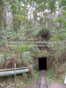
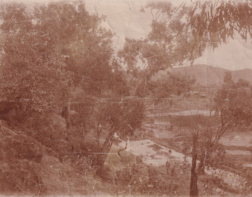
Photograph - Digital Photograph, Marguerite Marshall, One Tree Hill Mine, Smiths Gully, 8 June 2006
... Gully (now Research). * None of these compared in riches to the Ballarat and Bendigo fields5, but the Caledonia Diggings continued intermittently for close to 100 years. Gold was discovered in Victoria...Gully (now Research). * None of these compared in riches to the Ballarat and Bendigo fields5, but the Caledonia Diggings continued intermittently for close to 100 years. Gold was discovered in Victoria ...Gold was discovered on One Tree Hill in 1854. The site has been worked intermittently until fairly recent times. Published: Nillumbik Now and Then / Marguerite Marshall 2008; photographs Alan King with Marguerite Marshall.; p53 Though still a working mine, One Tree Hill Mine at Smiths Gully, now stands in a tranquil reserve surrounded by bush and native animals - in contrast to its heyday. In the mid 19th century, when the mine was part of the Caledonia Goldfields, hundreds of men in search of their fortune worked the alluvial gold in the Yarra River, its tributaries and the reefs that made up the goldfields. Miner Stan Bone, assisted by Wilfred Haywood, is the last of the independent gold miners in the area and still uses the quartz crushing battery as miners did when gold was first discovered in the area in 1851.1 Stan, who is the last of six generations of miners in his family, was aged 17 when he began mining on his father Alex’ mine, The Golden Crown in Yarrambat. These days, after blasting the gold-bearing rock in Mystery Reef, one of the four reefs at One Tree Hill, Stan transports it around five kilometres by tip truck to the Black Cameron Mine for crushing. There he uses water from the waterlogged mine, (which still contains gold), as the Happy Valley Creek at One Tree Hill is usually dry.2 The One Tree Hill Mine has been worked for close to a century since it opened around the late 1850s.3 The Swedish Reef was its most productive reef and one of the largest in the area. Around 1859, extractions included 204 ounces (5.8kg) of gold, won from 57 pounds (26kg) of stone.4 Then during World War Two, Stan’s uncle, Bill Wallace, and Alex Bone, closed the mine. In 1973, Stan, with his Uncle Bill, reopened the Black Cameron Mine and worked there until 1988. Stan resumed mining One Tree Hill in 1998. As late as the 1920s gold was picked up by chance! When crossing a gully on his way to vote at the St Andrews Primary School, Bill Joyce picked up some quartz containing gold. This site was to become the Black Cameron Mine. The Caledonia Diggings, named after Scotland’s ancient name by local Scots, began around Market Square (now Smiths Gully) and included Queenstown (St Andrews), Kingstown (Panton Hill) and Diamond Creek. There were also poorer bearing fields in Kangaroo Ground and Swipers Gully (now Research). * None of these compared in riches to the Ballarat and Bendigo fields5, but the Caledonia Diggings continued intermittently for close to 100 years. Gold was discovered in Victoria following a bid to stem the disappearance of much needed workmen to the New South Wales diggings. Several businessmen offered a reward of £200, for the discovery of gold within 200 miles (322 km) of Melbourne. Late in June 1851, gold was first discovered at Andersons Creek, Warrandyte. Then in 1854, George Boston and two other men discovered gold at Smiths Gully. Gold transformed the quiet districts, with a constant flow of families and vehicles on the dirt tracks en route to the Caledonia Diggings. Three thousand people worked the gullies in Market Square, including about 1000 Chinese miners. The square established its own police, mining warden, gold battery, school, shops and cemetery and grog flowed. Market Square flourished until the middle 1860s. Bullocks transported quartz from the Caledonia Goldfields to the crushing machinery at the Queenstown/St Andrews Battery, near Smiths Gully Cemetery. It was destroyed by bushfire in 1962. By the late 1850s, most early alluvial fields were in decline, but minor rushes continued until around 1900 and some until the early 1940s. Some miners did well, although most earned little from their hard labour in the harsh and primitive conditions.6 But according to historian, Mick Woiwod, the gold fields helped to democratise society, as individuals from all walks of life were forced to share experiences, and the ability to succeed, depended less on inherited wealth or social rank.This collection of almost 130 photos about places and people within the Shire of Nillumbik, an urban and rural municipality in Melbourne's north, contributes to an understanding of the history of the Shire. Published in 2008 immediately prior to the Black Saturday bushfires of February 7, 2009, it documents sites that were impacted, and in some cases destroyed by the fires. It includes photographs taken especially for the publication, creating a unique time capsule representing the Shire in the early 21st century. It remains the most recent comprehenesive publication devoted to the Shire's history connecting local residents to the past. nillumbik now and then (marshall-king) collection, gold mining, one tree hill mine, smiths gully -
 The Beechworth Burke Museum
Photograph
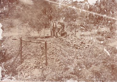
... Gully heritage mine near Fryers Creek, Victoria. 'Mopoke' is a common onomatopoeic name for Morepork and Australian Boobook owls. This image has historical, social and research ...This image is a reproduction of an 1899 original depicting the 'Williams Good Luck Mine' on the Mopoke Reef (also called 'Morepork Gully') in the Dingle Ranges, approximately three miles from Beechworth. A large opening to a mine can be seen behind the men in the photograph, with a wheeled cart on a track leading to the men's position, where the soil and rocks have been hauled away. This photograph interestingly contains dogs alongside the miners. While dogs have been recorded as deterrents to thieves in the Victorian goldfields, these dogs appear as companions to these men. Following the discovery of gold at Beechworth in 1852, rushes quickly followed at surrounding creeks and gullies in the district. In the late nineteenth and early twentieth centuries, small syndicates of miners continued to work old or abandoned quartz reefs, often persisting without the assistance of heavy machinery to remove the large amounts of rock, in order to obtain yields at ever greater depths. The group of miners in this photograph are Mr. Roger Williams and Sons, who revived operations at the ‘Old Good Luck’ mine on the Mopoke Reef in the Dingle Range near Beechworth around 1892, working the site for more than two decades. An emigrant from Cornwall with experience in the tin mining industry, 19 year old Roger Williams senior sailed to New Zealand in 1840, then to Australia where he spent time in the Bendigo Gold Fields before settling in Beechworth in the early 1860s. Mr Williams senior worked on various mining activities in the district, including the Rocky Mountain Tunnel project. Conversant with the character of gold-bearing reefs in the area, the syndicate dug an eight hundred foot tunnel, digging down as far down as two hundred feet with little capital save their labour, to connect and provide better working access to the mass of reefs and veins in the vicinity. Progress was hampered by poor air quality charged with fumes from dynamite and large quantities of rock had to be crushed to obtain payable yields. The Victorian Goldfields are filled with ruins and remnants of the area's rich mining history, ranging from small alluvial diggings to the remains of huge mining companies. Site names often changed several times throughout the nineteenth and twentieth centuries. Some sites were abandoned and forgotten, others were worked continuously over many decades. The names of mines were often repeated at different locations throughout the Victorian Goldfields. For example, there is a Mopoke Gully heritage mine near Fryers Creek, Victoria. 'Mopoke' is a common onomatopoeic name for Morepork and Australian Boobook owls.This image has historical, social and research significance for patterns of emigration during of the Victorian Gold Rush, and the historical, social and environmental impacts of mining at Beechworth at the turn of the nineteenth and twentieth centuries. As gold became scarce and government support and large company investment waned, poor hard-working miners laboured intensively to make a living through periods of high unemployment. This image can be compared and studied alongside other historical mining photographs and objects in the Burke Museum Collection. It has potential to improve our understanding of miners working conditions and the shifting character of mining in the Beechworth district.Sepia coloured rectangular photograph printed on gloss photographic paper mounted on card. Obverse: Williams/ Good/ Luck Reverse: A02498/ 1997. 2498/ Good Luck/ Mine/ 1899/ Mopoke. burke museum, beechworth museum, beechworth, gold fields, gold rush, victorian gold rush, gold ming history, colonial australia, australian gold rushes, mining technology, beechworth historic district, indigo gold trail, migration, indigo shire, good luck gold mine, victorian goldfields, mining syndicates, gold fever, quartz-mining, small-scale mining, old good luck mine, mopoke gully, quartz reefs beechworth -
 The Beechworth Burke Museum
Photograph
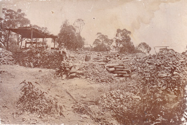
... Gully heritage mine near Fryers Creek, Victoria. 'Mopoke' is a common onomatopoeic name for Morepork and Australian Boobook owls. This image has historical, social and research ...This image is a reproduction of an 1899 original depicting the 'Williams Good Luck Mine' on the Mopoke Reef (also called 'Morepork Gully') in the Dingle Ranges, approximately three miles from Beechworth. The foreground of the image is littered with piles of smashed rock and detritus, known as ‘mullock’, beside a reinforced mine shaft, a vertical access passageway allowing miners to enter the mine and haul ore out using lifting technology such as a poppet heads, whims or windlasses. A group of miners and a dog appear close to an open-sided miner’s hut. Following the discovery of gold at Beechworth in 1852, rushes quickly followed at surrounding creeks and gullies in the district. In the late nineteenth and early twentieth centuries, small syndicates of miners continued to work old or abandoned quartz reefs, often persisting without the assistance of heavy machinery to remove the large amounts of rock, in order to obtain yields at ever greater depths. The group of miners in this photograph are Mr. Roger Williams and Sons, who revived operations at the ‘Old Good Luck’ mine on the Mopoke Reef in the Dingle Range near Beechworth around 1892, working the site for more than two decades. An emigrant from Cornwall with experience in the tin mining industry, 19 year old Roger Williams senior sailed to New Zealand in 1840, then to Australia where he spent time in the Bendigo Gold Fields before settling in Beechworth in the early 1860s. Mr Williams senior worked on various mining activities in the district, including the Rocky Mountain Tunnel project. Conversant with the character of gold-bearing reefs in the area, the syndicate dug an eight hundred foot tunnel, digging down as far down as two hundred feet with little capital save their labour, to connect and provide better working access to the mass of reefs and veins in the vicinity. Progress was hampered by poor air quality charged with fumes from dynamite and large quantities of rock had to be crushed to obtain payable yields. The Victorian Goldfields are filled with ruins and remnants of the area's rich mining history, ranging from small alluvial diggings to the remains of huge mining companies. Site names often changed several times throughout the nineteenth and twentieth centuries. Some sites were abandoned and forgotten, others were worked continuously over many decades. The names of mines were often repeated at different locations throughout the Victorian Goldfields. For example, there is a Mopoke Gully heritage mine near Fryers Creek, Victoria. 'Mopoke' is a common onomatopoeic name for Morepork and Australian Boobook owls.This image has historical, social and research significance for patterns of emigration during of the Victorian Gold Rush, and the historical, social and environmental impacts of mining at Beechworth at the turn of the nineteenth and twentieth centuries. As gold became scarce and government support and large company investment waned, poor hard-working miners laboured intensively to make a living through periods of high unemployment. This image can be compared and studied alongside other historical mining photographs and objects in the Burke Museum Collection. It has potential to improve our understanding of miners working conditions and the shifting character of mining in the Beechworth district.Sepia coloured rectangular photograph printed on gloss photographic paper mounted on card.Obverse: Reverse: A02497/ 1997.2497/ 'Good/ Luck/ Mine'/ Morepork/ Gully/ Mrs Joyce/ Bright/ Tunnel/ 800 ft/ 1899. burke museum, beechworth museum, beechworth, gold fields, gold rush, victorian gold rush, gold ming history, colonial australia, australian gold rushes, mining technology, beechworth historic district, indigo gold trail, migration, indigo shire, good luck gold mine, victorian goldfields, mining syndicates, gold fever, quartz-mining, small-scale mining, old good luck mine, mopoke gully, quartz reefs beechworth -
 The Beechworth Burke Museum
Photograph - Photograph - Reproduction, Unknown
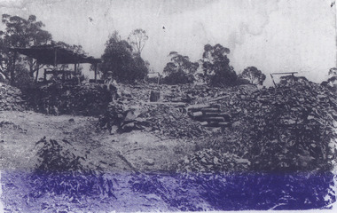
... Gully heritage mine near Fryers Creek, Victoria. 'Mopoke' is a common onomatopoeic name for Morepork and Australian Boobook owls. This image has historical, social and research ...This image is a reproduction of an 1899 original depicting the 'Williams Good Luck Mine' on the Mopoke Reef (also called 'Morepork Gully') in the Dingle Ranges, approximately three miles from Beechworth. The foreground of the image is littered with piles of smashed rock and detritus, known as ‘mullock’, beside a reinforced mine shaft, a vertical access passageway allowing miners to enter the mine and haul ore out using lifting technology such as a poppet heads, whims or windlasses. A group of miners and a dog appear close to an open-sided miner’s hut. Following the discovery of gold at Beechworth in 1852, rushes quickly followed at surrounding creeks and gullies in the district. In the late nineteenth and early twentieth centuries, small syndicates of miners continued to work old or abandoned quartz reefs, often persisting without the assistance of heavy machinery to remove the large amounts of rock, in order to obtain yields at ever greater depths. The group of miners in this photograph are Mr. Roger Williams and Sons, who revived operations at the ‘Old Good Luck’ mine on the Mopoke Reef in the Dingle Range near Beechworth around 1892, working the site for more than two decades. An emigrant from Cornwall with experience in the tin mining industry, 19 year old Roger Williams senior sailed to New Zealand in 1840, then to Australia where he spent time in the Bendigo Gold Fields before settling in Beechworth in the early 1860s. Mr Williams senior worked on various mining activities in the district, including the Rocky Mountain Tunnel project. Conversant with the character of gold-bearing reefs in the area, the syndicate dug an eight hundred foot tunnel, digging down as far down as two hundred feet with little capital save their labour, to connect and provide better working access to the mass of reefs and veins in the vicinity. Progress was hampered by poor air quality charged with fumes from dynamite and large quantities of rock had to be crushed to obtain payable yields. The Victorian Goldfields are filled with ruins and remnants of the area's rich mining history, ranging from small alluvial diggings to the remains of huge mining companies. Site names often changed several times throughout the nineteenth and twentieth centuries. Some sites were abandoned and forgotten, others were worked continuously over many decades. The names of mines were often repeated at different locations throughout the Victorian Goldfields. For example, there is a Mopoke Gully heritage mine near Fryers Creek, Victoria. 'Mopoke' is a common onomatopoeic name for Morepork and Australian Boobook owls. This image has historical, social and research significance for patterns of emigration during of the Victorian Gold Rush, and the historical, social and environmental impacts of mining at Beechworth at the turn of the nineteenth and twentieth centuries. As gold became scarce and government support and large company investment waned, poor hard-working miners laboured intensively to make a living through periods of high unemployment. This image can be compared and studied alongside other historical mining photographs and objects in the Burke Museum Collection. It has potential to improve our understanding of miners working conditions and the shifting character of mining in the Beechworth district. Black and white rectangular reproduction photograph printed on matte photographic paper.Obverse: Williams Good Luck Mine Beechworth / Roger! / Reverse: 6858 / burke museum, beechworth museum, beechworth, gold fields, gold rush, victorian gold rush, gold ming history, colonial australia, australian gold rushes, mining technology, beechworth historic district, indigo gold trail, migration, indigo shire, good luck gold mine, victorian goldfields, mining syndicates, gold fever, quartz-mining, small-scale mining, old good luck mine, mopoke gully, quartz reefs beechworth -
 The Beechworth Burke Museum
Photograph, 1907-8
... research into the history of El Dorado, a small regional location near Wangaratta in Victoria's North East. Therefore, this image has the capacity to be beneficial for research into society and the motivations of those living and working in this region during this period and therefore, has social significance. The Beechworth Burke Museum has additional images relating to gold sluicing and El Dorado which can be analysed and studied alongside images like this one. sluicing hydraulic sluicing 1907 1908 mining cock's pioneer gold & tin sluicing co nz nz site no 2 matthews gully west valley building cottages hillside trees water gold and tin mine Reverse: 1997. 2613/ A02613/ No2 site/ Matthews Gully/ Cocks Pioneer G&T. ?? ...The photo from 1907-8 is a sepia print, depicting a small valley with building at base. There are flumes visible above areas of water, trees on hills and a few small cottages on the hillside. Cock's Pioneer Gold & Tin Sluicing Co NZ No 2 Site. The photo was taken of Matthews Gully looking west. Sluicing was undertaken in the area from 1900 to 1942 with some short breaks between these periods. The image depicts a location mined by Cocks Pioneer Gold and Tin Sluicing Company (as recorded on the annotation on the card mount) The Cocks Pioneer Gold and Tin Mines N.L was one of El Dorado's two largest open cut sluicing mines of the 20th Century. The other was named the Cocks El Dorado Gold Dredging Company. The Cocks Pioneer Mines operated from 1901 until 1941 and found a total of 117,378 ounces of Gold and 1,673 tones of tin concentrates over these years. The Cocks company was formed in 1898 and operated until 1941. Open cut sluicing involved the use of high-powered hoses which used the centrifugal sand pump system (known as hydraulic sluicing) which broke down the soil which was then processed for gold and other precious metals. From 1914 , four years after this image was captured, the company reformed to Cocks Pioneer Gold and Tin Mines NL (previously it was known as Cocks Pioneer Sluicing Co) and undertook large scale sluicing operations until 1929 and then 1934-1941. El Dorado is located on Reedy Creek and is surrounded by forested country to the north and east. It is 20 km east of Wangaratta in Victoria's regional north-east. John Cock was the son of a Cornish minor who arrived in El Dorado in 1858. Cock founded his gold and tin mining company which ran successfully for many years in the El Dorado region. It was an open cut sluicing company because of the abandonment of underground mining after this was deemed too dangerous. In 1935 Cock's El Dorado Company commissioned the floating dredge which is still visible in El Dorado today. The dredge was built by the Thompson engineering works, Castlemaine, and weighed over 2,000 tones and today has a place on the Victorian Registers of historic buildings. Interestingly, the name El Dorado does not derive from the gold in the region, but from the Barambogie pastoral run completed by William Baker in 1840-1841. Gold was discovered in El Dorado 1854 but the gold was too deep for individual prospectors to find, it required the use of heavy machinery.The search for gold is ingrained into the history of Victoria and therefore, images like this one which portray an open cut sluicing site can reveal important information for society and technology for the date when the photograph was taken. This image is of important historical significance for its ability to convey information about sluicing and the methods used to find gold in 1910. It also shows a location where sluicing was undertook which provides insight into the impact of sluicing on the environment at a time when it was done. This image is important for current research into the history of El Dorado, a small regional location near Wangaratta in Victoria's North East. Therefore, this image has the capacity to be beneficial for research into society and the motivations of those living and working in this region during this period and therefore, has social significance. The Beechworth Burke Museum has additional images relating to gold sluicing and El Dorado which can be analysed and studied alongside images like this one.Sepia coloured rectangle photograph printed on gloss photographic paper Reverse: 1997. 2613/ A02613/ No2 site/ Matthews Gully/ Cocks Pioneer G&T. ?? Co NZ/ No2 Site looking West/ 1907-8/ (7)sluicing, hydraulic sluicing, 1907, 1908, mining, cock's pioneer gold & tin sluicing co nz, nz, site no 2, matthews gully, west, valley, building, cottages, hillside, trees, water, gold and tin mine -
 Bendigo Historical Society Inc.
Book - LONG GULLY HISTORY GROUP COLLECTION: FOOTPRINTS ON THE SANDS OF TIME
... Gully History Group - Footprints on the Sands of Time... Professor Jeff Brownrigg... Research and Outreach Screensound Australia... La Trobe University Bendigo... Sir John Quick... Bendigonian Annual... Bendigo School of Mines... British Empire... Alfred Deakin... Sir William Lyne... King O'Malley's Commonwealth Bank... Telstra... Sir Frederick Holder... Robert Garran... John McKay... The Mirror... Henry Gyles Turner... Fischer... State Library of Victoria...History House 11 Mackenzie Street Bendigo goldfields BENDIGO History long gully history group The Long Gully History Group - Footprints on the Sands of Time Professor Jeff Brownrigg Research and Outreach Screensound Australia La Trobe University Bendigo Sir John Quick Bendigonian Annual Bendigo School of Mines British Empire Alfred Deakin Sir William Lyne King O'Malley's Commonwealth Bank Telstra Sir Frederick Holder Robert Garran John McKay The Mirror Henry Gyles Turner Fischer State Library of Victoria Bishop Reville Bendigo Evening News Bendigo Independent Bendigo Advertiser Melbourne University Melbourne Age Richard Twopenny Mr Donald Clarke Esq Bendigo's Butter Factory Madame Carandini Amy Sherwin Nellie Melba Oscar Commetant Shamrock Hotel Constitutional Convention Adelaide Frederick Holder Edmund Barton Catherine Helen Spence Elizabeth Nicholls Women's Christian Temperance Union Mary Lee Rose Scott Susan Margery Maybanke Anderson Vida Goldstein Bendigonian Annual Amy Castles Alice Crawford Edward Allan Bindley Joseph Castles Mercy Conent Freeman's Journal Catholic Press Therese Radic Melba State Library of Victoria Cardinal Moran De Quiros Bulletin John Norton D Headon J Brownrigg Lili Sharp Eileen Castles Mike Sutcliffe Melbourne Argus Frank Cusack David Horsfall Alvin Tracey Melbourne's Advocate Press Amy Sherwin Frances Saville Lalla Miranda Hugo Gorlitz Samuels Family Louis August Samuels Kate (Catherina) Samuels Madame Benda Mathilde Marchesi Emily Dyason Erna (Lovie) Mueller The German Chapter German heritage Society Bendigo Bertha Rossow Hamilton Hill Beatrice English Anthony Palamountain Alfred Bottoms A C Bartlemann Dorothy Penfold Dr Penfold Penfold Gallery Pauline Bindley E A Bindley Willie Murdoch Sister Mary Tarcisia Sisters of Mercy Peter Dawson Bendigo's Chinese Populatin Masonic Hall Ashman's Dry-cleaners Walter Murdoch Lily Baxter Walter Savage Landor Robert Garran Ada Colley Australian Journal of Communication Michelle Matthews Book titled Footprints on the Sands of Time: Bendigo's Citizens, the 1909 Bendigonian Annual and Community History with a grey tone cover with images of Sir John Quick, Amy Castles, Amy and Eileen Castles and Anthony Palamountain on the front and back covers. ...Book titled Footprints on the Sands of Time: Bendigo's Citizens, the 1909 Bendigonian Annual and Community History with a grey tone cover with images of Sir John Quick, Amy Castles, Amy and Eileen Castles and Anthony Palamountain on the front and back covers. La Trobe University, Bendigo The Ninth Sir John Quick Bendigo Lecture 2 October 2002. Lecture by Professor Jeff Brownrigg, Head of Research and Outreach ScreenSound Australia, Canberra. Mentioned in the book is Sir John Quick, Some women of the early 20th Century, Bendigo's singers and opera singers and why communities all over Australia must face up to the challenges of global media by first recognizing the value of their own stories. Mentioned at the back of the book is a brief mention of Professor Jeff Brownrigg's career, John Quick's career and a list of The Sir John Quick Bendigo Lecture Series from 1994 to 2001.bendigo, history, long gully history group, the long gully history group - footprints on the sands of time, professor jeff brownrigg, research and outreach screensound australia, la trobe university bendigo, sir john quick, bendigonian annual, bendigo school of mines, british empire, alfred deakin, sir william lyne, king o'malley's commonwealth bank, telstra, sir frederick holder, robert garran, john mckay, the mirror, henry gyles turner, fischer, state library of victoria, bishop reville, bendigo evening news, bendigo independent, bendigo advertiser, melbourne university, melbourne age, richard twopenny, mr donald clarke esq, bendigo's butter factory, madame carandini, amy sherwin, nellie melba, oscar commetant, shamrock hotel, constitutional convention adelaide, frederick holder, edmund barton, catherine helen spence, elizabeth nicholls, women's christian temperance union, mary lee, rose scott, susan margery, maybanke anderson, vida goldstein, bendigonian annual, amy castles, alice crawford, edward allan bindley, joseph castles, mercy conent, freeman's journal, catholic press, therese radic melba, state library of victoria, cardinal moran, de quiros, bulletin, john norton, d headon, j brownrigg, lili sharp, eileen castles, mike sutcliffe, melbourne argus, frank cusack, david horsfall, alvin tracey, melbourne's advocate press, amy sherwin, frances saville, lalla miranda, hugo gorlitz, samuels family, louis august samuels, kate (catherina) samuels, madame benda, mathilde marchesi, emily dyason, erna (lovie) mueller, the german chapter, german heritage society bendigo, bertha rossow, hamilton hill, beatrice english, anthony palamountain, alfred bottoms, a c bartlemann, dorothy penfold, dr penfold, penfold gallery, pauline bindley, e a bindley, willie murdoch, sister mary tarcisia, sisters of mercy, peter dawson, bendigo's chinese populatin, masonic hall, ashman's dry-cleaners, walter murdoch, lily baxter, walter savage landor, robert garran, ada colley, australian journal of communication, michelle matthews -
 Bendigo Historical Society Inc.
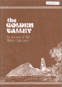
Book - THE GOLDEN VALLEY, 1980
... Gully Mine, illustrated with colour photos. Booklet prepared to commemorate the reopening of the mine by Rupert Hamer, Premier of Victoria in 1980. On page 15 is a handwritten note in biro 'To Ray Wallace - I had great pleasure in researching, photographing & preparing all the information here - this was a limited-edition publication for shareholders of Wattle Gully in 1980 Regards Felix Cappy' ...Gully Mine, illustrated with colour photos. Booklet prepared to commemorate the reopening of the mine by Rupert Hamer, Premier of Victoria in 1980. On page 15 is a handwritten note in biro 'To Ray Wallace - I had great pleasure in researching, photographing & preparing all the information here - this was a limited-edition publication for shareholders of Wattle Gully in 1980 Regards Felix Cappy' Book THE GOLDEN VALLEY ...32 page soft cover booklet 'The Golden Valley - An account of the Wattle Gully Area.' An account of the rehabilitation of the Wattle Gully Mine, illustrated with colour photos. Booklet prepared to commemorate the reopening of the mine by Rupert Hamer, Premier of Victoria in 1980. On page 15 is a handwritten note in biro 'To Ray Wallace - I had great pleasure in researching, photographing & preparing all the information here - this was a limited-edition publication for shareholders of Wattle Gully in 1980 Regards Felix Cappy' wattle gully, mining -
 Bendigo Historical Society Inc.
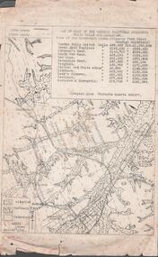
Document - MINING REPORTS - MAP OF PART OF THE BENDIGO GOLDFIELD INCLUDING WHITE HILLS AND EAGLEHAWK
... gullies, railway line, tram route, type of rock, name of mine, Calls and Dividends. Also Deepest Mine Victoria Quartz 4614 ft. Names of Mines are Garden Gully United, Great Ext'd Hustlers, Johnson's Reef, South New Moon, New Moon, Catherine Reef, Virginia, Central Red White & Blue, Ironbark, Kock's Pioneer, Carlisle and the Hercules & Energetic. Map is part of the Albert Richardson Collection of mining documents and research...Victoria Quartz Map of part of the Bendigo Goldfield including White Hills and Eaglehawk. Map shows reef lines, gullies, railway line, tram route, type of rock, name of mine, Calls and Dividends. Also Deepest Mine Victoria Quartz 4614 ft. Names of Mines are Garden Gully United, Great Ext'd Hustlers, Johnson's Reef, South New Moon, New Moon, Catherine Reef, Virginia, Central Red White & Blue, Ironbark, Kock's Pioneer, Carlisle and the Hercules & Energetic. Map is part of the Albert Richardson Collection of mining documents and research ...BHS CollectionMap of part of the Bendigo Goldfield including White Hills and Eaglehawk. Map shows reef lines, gullies, railway line, tram route, type of rock, name of mine, Calls and Dividends. Also Deepest Mine Victoria Quartz 4614 ft. Names of Mines are Garden Gully United, Great Ext'd Hustlers, Johnson's Reef, South New Moon, New Moon, Catherine Reef, Virginia, Central Red White & Blue, Ironbark, Kock's Pioneer, Carlisle and the Hercules & Energetic. Map is part of the Albert Richardson Collection of mining documents and research. document, gold, mining reports, mining reports, map of part of the bendigo goldfield including white hills and eaglehawk, pabst bendigo goldfield, garden gully united, great ext'd hustlers, johnson's reef, south new moon, new moon, catherine reef, virginia, central red white & blue, ironbark, kock's pioneer, carlisle, hercules & energetic. victoria quartz -
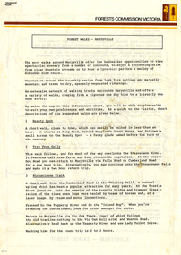 Marysville & District Historical Society
Flyer (Item) - Information Flyer, Forests Commission, Victoria, FOREST WALKS - MARYSVILLE, 1918-1983
... research and making recommendations on the acquisition or alienation of land for forest purposes″. An extensive network of walking tracks surrounds Marysville and they offer a variety of walks ranging in various levels of difficulty. This information flyer provides information such as the level of difficulty for six suggested walks around Marysville. An information flyer that was produced as a guide to the forest walks in and near Marysville by the Forests Commission of Victoria. marysville victoria australia forest walks forests commission victoria beauty spot walk tree fern gully ...An information flyer that was produced as a guide to the forest walks in and near Marysville by the Forests Commission of Victoria. The Forests Commission Victoria (FCV) was the main government authority responsible for management and protection of State forests in Victoria, Australia between 1918 and 1983. The Commission was responsible for ″forest policy, prevention and suppression of bushfires, issuing leases and licences, planting and thinning of forests, the development of plantations, reforestation, nurseries, forestry education, the development of commercial timber harvesting and marketing of produce, building and maintaining forest roads, provision of recreation facilities, protection of water, soils and wildlife, forest research and making recommendations on the acquisition or alienation of land for forest purposes″. An extensive network of walking tracks surrounds Marysville and they offer a variety of walks ranging in various levels of difficulty. This information flyer provides information such as the level of difficulty for six suggested walks around Marysville.An information flyer that was produced as a guide to the forest walks in and near Marysville by the Forests Commission of Victoria.marysville, victoria, australia, forest walks, forests commission victoria, beauty spot walk, tree fern gully walk, michaeldene track, keppel track, woods lookout track -
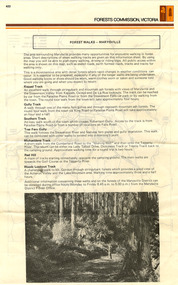 Marysville & District Historical Society
Flyer (Item) - Information Flyer, Forests Commission, Victoria, FOREST WALKS - MARYSVILLE, 1918-1983
... research and making recommendations on the acquisition or alienation of land for forest purposes″. An extensive network of walking tracks surrounds Marysville and they offer a variety of walks ranging in various levels of difficulty. This information flyer provides information such as the level of difficulty for six suggested walks around Marysville. An information flyer that was produced as a guide to the forest walks in and near Marysville by the Forests Commission of Victoria. marysville victoria australia forest walks forests commission victoria beauty spot walk tree fern gully ...An information flyer that was produced as a guide to the forest walks in and near Marysville by the Forests Commission of Victoria. The Forests Commission Victoria (FCV) was the main government authority responsible for management and protection of State forests in Victoria, Australia between 1918 and 1983. The Commission was responsible for ″forest policy, prevention and suppression of bushfires, issuing leases and licences, planting and thinning of forests, the development of plantations, reforestation, nurseries, forestry education, the development of commercial timber harvesting and marketing of produce, building and maintaining forest roads, provision of recreation facilities, protection of water, soils and wildlife, forest research and making recommendations on the acquisition or alienation of land for forest purposes″. An extensive network of walking tracks surrounds Marysville and they offer a variety of walks ranging in various levels of difficulty. This information flyer provides information such as the level of difficulty for six suggested walks around Marysville.An information flyer that was produced as a guide to the forest walks in and near Marysville by the Forests Commission of Victoria.marysville, victoria, australia, forest walks, forests commission victoria, beauty spot walk, tree fern gully walk, michaeldene track, keppel track, woods lookout track