Showing 5481 items matching residential
-
 Whitehorse Historical Society Inc.
Photograph, Forest Hill Residential Kindergarten, c1938
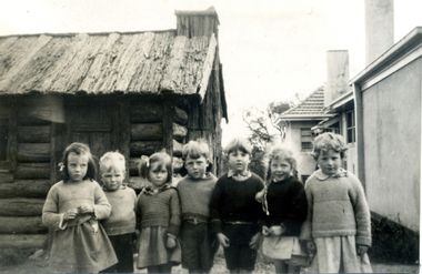
See ND2991 for history of kindergartenBlack & white photo of children from Montague and Renown Kindergarten at the Forest Hill Residential Holiday Home. Shed behind seven children.forest hill residential kindergarten, kindergarten -
 Whitehorse Historical Society Inc.
Pamphlet, Forest Hill Residential Kindergarten 1926-1976, 1976
Forest Hill Residential Kindergarten 1926-1976.Forest Hill Residential Kindergarten 1926-1976. A history from Holiday Home to Emergency Care. Published to commemorate the fiftieth anniversary. Foreword by Christine Heinig.Forest Hill Residential Kindergarten 1926-1976. forest hill holiday home, forest hill residential kindergarten, forster, hilda, butler, mary, gregory, kathleen maie, curtain, carmel, preschools -
 Whitehorse Historical Society Inc.
Photograph, Forest Hill Residential Kindergarten - stacking hay, c1938
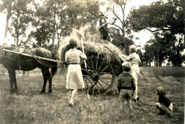
See ND2991 for history of kindergarten.Sepia photograph of people stacking hay on a cart at the Forest Hill Residential Kindergarten. Two women with two children standing by with and a man standing on top of hay.forest hill residential kindergarten, kindergarten -
 Whitehorse Historical Society Inc.
Photograph, Forest Hill Residential Kindergarten - cart full of hay, c1938
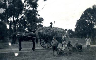
See ND2991 for history of kindergarten.Black & white photograph of a horse drawn cart full of hay with a man sitting on top. Six children in the foreground. taken at the Forest Hill Residential Kindergarten.forest hill residential kindergarten, kindergarten -
Whitehorse Historical Society Inc.
Pamphlet, Forest Hill Residential Kindergarten 1926-1976, 1976
History of Forest Hill Residential Kindergarten, sub-titled from Holiday Home to Emergency2 Copies of History of Forest Hill Residential Kindergarten, sub-titled from Holiday Home to Emergency Care, published to commemorate 50th Anniversary of the Kindergarten.History of Forest Hill Residential Kindergarten, sub-titled from Holiday Home to Emergency preschools, forest hill residential kindergarten -
 Ringwood and District Historical Society
Flyer, Township Shop Sites and Residential Allotments Sale By Public Auction, Ringwood, Victoria - 1926
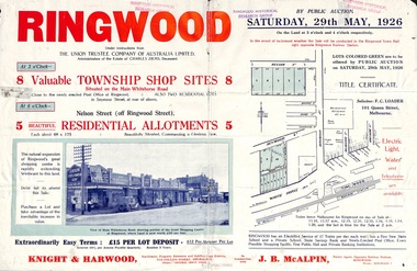
Advertisement for eight township shop sites and five residential allotments for sale by Public Auction on the land in Ringwood on Saturday, 29th May, 1926, with location map, and summary of local features and services. Locality plan highlights sites for auction in Nelson Street, Seymour Street and Whitehorse Road. (Agents) Knight & Harwood, 315 Collins Street, Melbourne, Phones 10615, 10616 Central, in conjunction with J.B. McAlpin, Estate Agent, Opposite Railway Station, Ringwood, Phone Ringwood 7. -
 Greensborough Historical Society
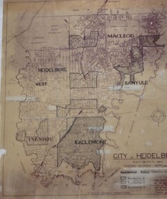
Map, City of Heidelberg: Residential Policy, 1976c
Shows residential zones 3, 4 & 5 established by Residential Policy adopted 13/12/1976Black print on waxed paper. Scale: 20 chs to 1 inchG M Hutchins. $1city of heidelberg, heidelberg -
 Eltham District Historical Society Inc
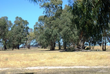
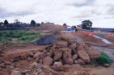
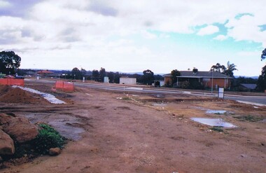
Slide - Photograph, Unidentified residential scene, c.Jun. 1985
35mm colour positive transparency (1 of 15) Mount - Kodak Kodachrome CardLen Big Topinfrastructure, residential, road drainage, roads, unidentified -
 Greensborough Historical Society
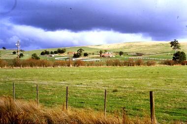
Slide - Photograph, John Ramsdale, Residential development, Whittlesea: Slide 68, 1990s
Photograph shows a residential development in Whittlesea.Part of the John Ramsdale collection of slides and audio visual material.Colour photograph scanned from slide.No maker's marks. No caption on slide.residential development, whittlesea -
 Eltham District Historical Society Inc
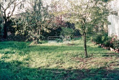
Slide - Photograph, Typical residential backyard, possibly Eltham, c.1968
35mm colour positive transparency blue Agfacolour Service plastic mountunidentified, eltham, backyard, gardens, houses, residential -
 Greensborough Historical Society
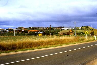
Slide - Photograph, John Ramsdale, Residential development south of Whittlesea: Slide 92, 1990s
Photograph shows residential development south of Whittlesea encroaching on farmland.Part of the John Ramsdale collection of slides and audio visual material.Colour photograph scanned from slide.No maker's marks. No caption on slide.whittlesea, residential development -
 Greensborough Historical Society
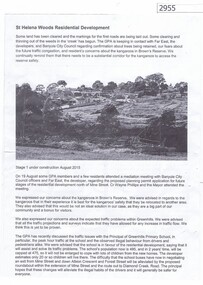
Article, Greenhills Progress Association, St Helena Woods Residential Development, 19/08/2015
Concerns by the Greenhills Progress Association and residents about the St Helena Woods residential development by Far East.One page, text and photograph st helena woods, greenhills progress associatiion -
 Expression Australia
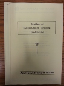
Booklet, Adult Deaf Society of Victoria Residential Independence Training Programme
Produced 19/5/80 to provide information generally about the residential programme and specifically for decisions on funding29.5cmHx21cmW, 12 pages, 2 copiesadult deaf society of victoria, residential independence training programme funding -
 Eltham District Historical Society Inc
Slide - Photograph, Unidentified residential street, possibly Eltham North, c.Oct. 1989
35mm colour positive transparency Mount - Black and Whiteinfrastructure, streets, roads, eltham north, houses, residential, streetscape, unidentified -
 Greensborough Historical Society
Photograph - Digital image, Marilyn Smith et al, Janefield Precinct: Looking towards the future - new residential development, 27/11/2014
Janefield Precinct: Looking towards the future - new residential development. The remains of this site are between Greensborough and Janefield. A RAAF Hygiene Training Camp was located on the Plenty River, just south of the Janefield community. It was in use from 1944 to 1946. The Camp was constructed from salvaged materials. Instruction included building and maintenance of grease traps, latrines, elementary plumbing and carpentry.Early remains of a WW2 training camp Digital colour photograph.janefield -
 Melbourne Tram Museum
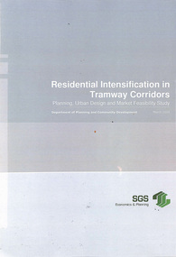
Document - Report, SGS Economics and Planning, "Residential Intensification of Tramway Corridors", May. 2009
Report - 130 pages - wire bound, plastic and card covers, titled "Residential Intensification of Tramway Corridors", prepared for the Department of Planning and Community Development by SGS Economics and Planning March 2009. Look at the development along the Nicholson St and the West Preston lines in particular. Does a detail examination of the development opportunities, including major sites that were available at the time. Does not appear to address how to capture the value of having a tram line along these areas or how to provide additional services. Development has taken place since along these and other corridors. Final Report. Table of contents and Executive Summary scanned.trams, tramways, tram routes, east preston, nicholson st, passengers, development -
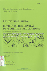 Eltham District Historical Society Inc
Document - Book, Econsult Planning and Development Pty Ltd, Residential Study: Review of Residential Development Regulations; Final Report; Volumes 1 and 2, October 1991
Report by Consultants Econsult Planning & Development produced under the Steering Committee guidance of the City of Doncaster and Templestowe and the Shire of Eltham recognising a lack of diversity in housing stock to meet changing housing needs. The Study objectives are: *To provide for a wide variety of housing choices and lot sizes *To make housing more accessible taking into account the Australian Model Code *To maintain residnetial amenity by taking into account significant local features *To prepare guidelines and policities which consider slope, lot, size, location, availability of services and significant vegeation. *To determine the housing types and lot sizes, required by new residents in different locationsresidential development, housing -
 Kew Historical Society Inc
Plan - Subdivision Plan, 6 Choice Residential Allotments: East Kew, 1932
Prue Sanderson, in her groundbreaking ‘City of Kew Urban Conservation Study : Volume 2 - Development History’ (1988), summarised the periods of urban development and subdivisions of land in Kew. The periods that she identified included 1845-1880, 1880-1893, 1893-1921, 1921-1933, 1933-1943, and Post-War Development. These periods were selected as they represented periods of rapid growth or decline in urban development. An obvious starting point for Sanderson’s groupings involved population growth and the associated economic cycles. These cycles also highlighted urban expansion onto land that was predominantly rural, although in other cases it represented the decline and breakup of large estates. A number of the plans in the Kew Historical Society’s collection can also be found in other collections, such as those of the State Library of Victoria and the Boroondara Library Service. A number are however unique to the collection.Subdivision plans are historically important documents used as evidence of the growth of suburbs in Australia. They frequently provide information about when the land was sold on which a built structure was subsequently constructed as well as evidence relating to surveyors and real estate and financial agents. The numerous subdivision plans in the Kew Historical Society's collection represent working documents, ranging from the initial sketches made in planning a subdivision to printed plans on which auctioneers or agents listed the prices for which individual lots were sold. In a number of cases, the reverse of a subdivision plan in the collection includes a photograph of a house that was also for sale by the agent. These photographs provide significant heritage information relating house design and decoration, fencing and household gardens.The mansion Woodlands in Harp Road, East Kew suffered the death of a thousand cuts. In its case, the cuts were subdivisions. Previous subdivisions of the mansion and its grounds were given titles such as ‘The Eastlawn Estate’ (MAP.0055), whereas at the end, the subdivision called it as it was, naming itself the ‘final section of the Woodlands Estate’ when it was put up for auction in 1932. The emphasis in the promotion of the subdivision was that it provided purchasers with splendid opportunities ‘to build modern homes in select, well established modern surroundings’. As with other subdivisions in the interwar period, transport links were emphasised. The six residential lots cut Woodlands off from Harp Road. When the vendor, Louisa Rachel Preston Hill, was to die at Woodlands in 1937 aged 86 her address was given as Normanby Road.subdivision plans - kew, woodlands estate -
 Greensborough Historical Society
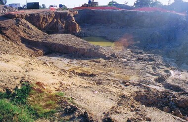
Photograph - Digital image, Frank Solomon, Development of pig farm to residential blocks, 1, 02/08/2009
A view of the redevelopment of the pig farm in Weidlich Road Greensborough, owned by Werner Hanusch. The land was used as a pig farm and quarry from 1954 and this photo shows early stages of the land being subdivided into the Evelyn Way estate. This project of fifty, one double storey, dwellings was commenced on 2/8/2009 and completed on 6/2/2011.An example of the changing land use in Greensborough, from farming to residential.Digital copy of colour photographwerner otto fritz hanusch, pig farm st helena, weidlich road greensborough, one evelyn way greensborough -
 Greensborough Historical Society
Photograph - Digital image, Frank Solomon, Development of pig farm to residential blocks, 2, 02/08/2009
A view of the redevelopment of the pig farm in Weidlich Road Greensborough, owned by Werner Hanusch. The land was used as a pig farm and quarry from 1954 and this photo shows early stages of the land being subdivided into the Evelyn Way estate. This project of fifty, one double storey, dwellings was commenced on 2/8/2009 and completed on 6/2/2011.An example of the changing land use in Greensborough, from farming to residential.Digital copy of colour photographwerner otto fritz hanusch, pig farm st helena, weidlich road greensborough, one evelyn way greensborough -
 Greensborough Historical Society
Photograph - Digital image, Frank Solomon, Development of pig farm to residential blocks, 3, 02/08/2009
A view of the redevelopment of the pig farm in Weidlich Road Greensborough, owned by Werner Hanusch. The land was used as a pig farm and quarry from 1954 and this photo shows early stages of the land being subdivided into the Evelyn Way estate. This project of fifty, one double storey, dwellings was commenced on 2/8/2009 and completed on 6/2/2011.An example of the changing land use in Greensborough, from farming to residential.Digital copy of colour photographwerner otto fritz hanusch, pig farm st helena, weidlich road greensborough, one evelyn way greensborough -
 Greensborough Historical Society
Photograph - Digital image, Frank Solomon, Development of pig farm to residential blocks, 4, 02/08/2009
A view of the redevelopment of the pig farm in Weidlich Road Greensborough, owned by Werner Hanusch. The land was used as a pig farm and quarry from 1954 and this photo shows early stages of the land being subdivided into the Evelyn Way estate. This project of fifty, one double storey, dwellings was commenced on 2/8/2009 and completed on 6/2/2011.An example of the changing land use in Greensborough, from farming to residential.Digital copy of colour photographwerner otto fritz hanusch, pig farm st helena, weidlich road greensborough, one evelyn way greensborough -
 Greensborough Historical Society
Photograph - Digital image, Frank Solomon, Development of pig farm to residential blocks, 5, 02/08/2009
A view of the redevelopment of the pig farm in Weidlich Road Greensborough, owned by Werner Hanusch. The land was used as a pig farm and quarry from 1954 and this photo shows early stages of the land being subdivided into the Evelyn Way estate. This project of fifty, one double storey, dwellings was commenced on 2/8/2009 and completed on 6/2/2011.An example of the changing land use in Greensborough, from farming to residential.Digital copy of colour photographwerner otto fritz hanusch, pig farm st helena, weidlich road greensborough, one evelyn way greensborough -
RMIT GSBL Justice Smith Collection
Report, Residential tenancy databases : report, 2006
ReportISBN: 0975700685victoria. residential tenancies act 1997, rental housing -- victoria -- databases, landlord and tenant -- victoria -- databases -
University of Melbourne, Burnley Campus Archives
Document, The Residential Garden Design. Display, 1991
Part of Burnley College Centenery celebrationsburnley college, centenary, residential garden, design -
 Victorian Aboriginal Corporation for Languages
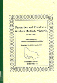
Book, Properties and residential : Western District, Victoria : mid 1800s - 1990s : names, time and place, 1997
Lists properties, names of residents and addresses of properties and residences in Western District, Victoria from the mid 1800s to 1990s. Listed in alphabetical order according to the name of the property, residence or place.western district victoria, residential directory, real estate directory -
 Kew Historical Society Inc
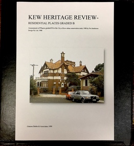
Archive (Sub-series) - Subject File, Kew Heritage Review, Residential Places Graded B, Volume 1, 1999
Graeme Butler & AssociatesProject FilesProvenance OrderBlack 4-Ring binder that includes research about, and an assessment of buildings previously graded B in the City of Kew Urban Conservation Study 1988 by Pru Sanderson Design Pty Ltd. The files were created by the heritage architect Graeme Butler and the paper files include maps, correspondence, title searches, readings, reviews of prior classifications, newspaper and journal articles, directories etc for each property assessed.graeme butler, heritage reviews - kew, 20 yarra street, 8 yarra street, 33 wills street, 25 wellington street, 11 wellington street, 118 walpole street, 84 walpole street, 83 walpole street, 63 walpole street, 52 walpole street, 51 walpole street, 14 vista avenue, 12 tara avenue, 89 studley park road, 75 studley park road, 44 studley park road, 25 studley park road, 13 studley avenue, 21 stoke avenue, 71 stevenson street, 34 stevenson street, 12 stevenson street, 36 stawell street, 11 second avenue, 3 second avenue, 2 second avenue, 34 rowland street, 21 redmond street, 11 redmond street, 16 queen street, 27 princess street, 82 molesworth street, 28 miller grove, 26 miller grove, 24 miller grove, 24 milfay avenue, 8 milfay avenue, 4 merrion grove, 25 mary street, 24 lister avenue, 2 john street, 9 hume street, 7 hume street, 24 howard street, 20 howard street, 19 howard street, 10 howard street, 2 howard street, 26 holroyd street, 12 holroyd street, 73 high street, 69 high street, 35 high street, 6 high street, 53 harp road, 6 gellibrand street, 48 foley street, 9 eglinton street, 25-27 edgecombe street, 21-23 edgecombe street, 5-7 edgecombe street, 23 dunlop avenue, 167 derby street, 8 denmark street, 1 denmark street, 2 daracomb avenue, 2 danielle place, 340 cotham road, 294 cotham road, 241 cotham road, 221-229 cotham road, 208 cotham road, 193 cotham road, 180 cotham road, 171 cotham road, 167 cotham road, 161 cotham road, 135-137 cotham road, 46 clyde street, 4 cameron court, 1291 burke road, 1223 burke road, 1205 burke road, 5 bowen street, 35-37 belford road, 389 barkers road, 387 barkers road, 311 barkers road, 231 barkers road, 83-85 barkers road, 15 adeney avenue, 6 a'beckett streetgraeme butler, heritage reviews - kew, 20 yarra street, 8 yarra street, 33 wills street, 25 wellington street, 11 wellington street, 118 walpole street, 84 walpole street, 83 walpole street, 63 walpole street, 52 walpole street, 51 walpole street, 14 vista avenue, 12 tara avenue, 89 studley park road, 75 studley park road, 44 studley park road, 25 studley park road, 13 studley avenue, 21 stoke avenue, 71 stevenson street, 34 stevenson street, 12 stevenson street, 36 stawell street, 11 second avenue, 3 second avenue, 2 second avenue, 34 rowland street, 21 redmond street, 11 redmond street, 16 queen street, 27 princess street, 82 molesworth street, 28 miller grove, 26 miller grove, 24 miller grove, 24 milfay avenue, 8 milfay avenue, 4 merrion grove, 25 mary street, 24 lister avenue, 2 john street, 9 hume street, 7 hume street, 24 howard street, 20 howard street, 19 howard street, 10 howard street, 2 howard street, 26 holroyd street, 12 holroyd street, 73 high street, 69 high street, 35 high street, 6 high street, 53 harp road, 6 gellibrand street, 48 foley street, 9 eglinton street, 25-27 edgecombe street, 21-23 edgecombe street, 5-7 edgecombe street, 23 dunlop avenue, 167 derby street, 8 denmark street, 1 denmark street, 2 daracomb avenue, 2 danielle place, 340 cotham road, 294 cotham road, 241 cotham road, 221-229 cotham road, 208 cotham road, 193 cotham road, 180 cotham road, 171 cotham road, 167 cotham road, 161 cotham road, 135-137 cotham road, 46 clyde street, 4 cameron court, 1291 burke road, 1223 burke road, 1205 burke road, 5 bowen street, 35-37 belford road, 389 barkers road, 387 barkers road, 311 barkers road, 231 barkers road, 83-85 barkers road, 15 adeney avenue, 6 a'beckett street -
 Kew Historical Society Inc
Archive (Sub-series) - Subject File, Kew Heritage Review, Residential Places Graded B, Volume 2, 1999
Graeme Butler & AssociatesProject FilesProvenance OrderBlack 4-Ring binder that includes research about, and an assessment of buildings previously graded B in the City of Kew Urban Conservation Study 1988 by Pru Sanderson Design Pty Ltd. The files were created by the heritage architect Graeme Butler and the paper files include maps, correspondence, title searches, readings, reviews of prior classifications, newspaper and journal articles, directories etc for each property assessed. graeme butler, heritage reviews - kew, 25 mary street, 4 merrion grove, 24 milfay avenue, 24 miller grove, 26 miller grove, 28 miller grove, 82 molesworth street, 27 princess street, 16 queen street, 20 yarra street, 84 walpole street, 118 walpole street, 11 wellington street, 83 walpole street, 25 wellington street, 8 yarra street, 33 wills street, 63 walpole street, 14 vista avenue, 89 studley park road, 12 tara avenue, 75 studley park road, 21 redmond street, 52 walpole street, 51 walpole street, 71 stevenson street, 34 rowland street, 21 stoke avenue, 34 stevenson street, 44 studley park road, 25 studley park road, 13 studley avenue, 2 second avenue, 11 second avenue, 3 second avenue, 36 stawell street, 12 stevenson streetgraeme butler, heritage reviews - kew, 25 mary street, 4 merrion grove, 24 milfay avenue, 24 miller grove, 26 miller grove, 28 miller grove, 82 molesworth street, 27 princess street, 16 queen street, 20 yarra street, 84 walpole street, 118 walpole street, 11 wellington street, 83 walpole street, 25 wellington street, 8 yarra street, 33 wills street, 63 walpole street, 14 vista avenue, 89 studley park road, 12 tara avenue, 75 studley park road, 21 redmond street, 52 walpole street, 51 walpole street, 71 stevenson street, 34 rowland street, 21 stoke avenue, 34 stevenson street, 44 studley park road, 25 studley park road, 13 studley avenue, 2 second avenue, 11 second avenue, 3 second avenue, 36 stawell street, 12 stevenson street -
 Kew Historical Society Inc
Archive (Sub-series) - Subject File, Kew Heritage Review, Residential Places Graded B, Volume 3, 1999
Graeme Butler & AssociatesProject FilesProvenance OrderBlack 4-Ring binder that includes research about, and an assessment of buildings previously graded B in the City of Kew Urban Conservation Study 1988 by Pru Sanderson Design Pty Ltd. The files were created by the heritage architect Graeme Butler and the paper files include maps, correspondence, title searches, readings, reviews of prior classifications, newspaper and journal articles, directories etc for each property assessed.graeme butler, heritage reviews - kew, 4 cameron court, 2 hodgson street, 20 fellows street, 26 fellows street, 23 highbury grove, kew lunatic asylum, kew mental hospital, willsmere, 36 stawell street, 13 studley avenue, 16 studley avenue, 20 studley avenue, raheen, studley park road, beament house, 33 uvadale road, 20 yarra streetgraeme butler, heritage reviews - kew, 4 cameron court, 2 hodgson street, 20 fellows street, 26 fellows street, 23 highbury grove, kew lunatic asylum, kew mental hospital, willsmere, 36 stawell street, 13 studley avenue, 16 studley avenue, 20 studley avenue, raheen, studley park road, beament house, 33 uvadale road, 20 yarra street -
Whitehorse Historical Society Inc.
Pamphlet, Forest Hill Residential Kindergarten, 1976
A History from holiday home to eme.rgency care, 1926-1976 and supplement from 1976 onwards by Wendy Syme and Audrey Holder.A History from holiday home to eme.rgency care, 1926-1976 and supplement from 1976 onwards by Wendy Syme and Audrey Holder.A History from holiday home to eme.rgency care, 1926-1976 and supplement from 1976 onwards by Wendy Syme and Audrey Holder.forest hill residential kindergarten, preschool education, lake road blackburn