Showing 4690 items matching "residential development"
-
 Sunshine and District Historical Society Incorporated
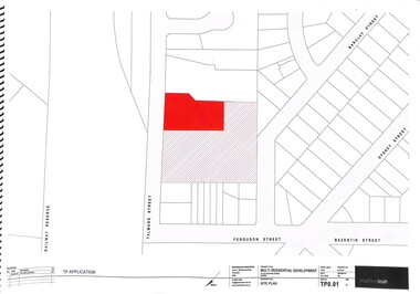
Document - Multi Residential Development 22 - 24 Talmage Street Albion
... Multi Residential Development 22 - 24 Talmage Street Albion...Collection of plans & photos of the proposed Multi Residential Development 22 - 24 Talmage Street Albion...Multi Residential Development 22 - 24 Talmage Street Albion...Talmage Street Albion Development Multi Residential Development 22 - 24 Talmage Street Albion Collection of plans & photos of the proposed Multi Residential Development 22 - 24 Talmage Street Albion Document Multi Residential Development 22 - 24 Talmage Street Albion ...Multi Residential Development 22 - 24 Talmage Street Albiontalmage street, albion, development -
 Sunshine and District Historical Society Incorporated
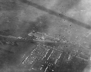
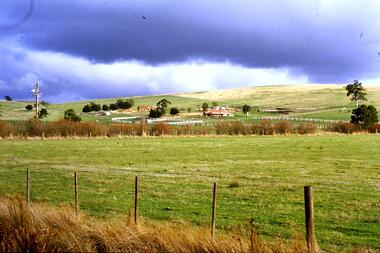
Photograph - HV McKays factory and residential development, 1920
... HV McKays factory and residential development...HV McKays factory and residential development...An aerial photograph of HV McKays factory and residential development for workers Depicts Sunshine area factory and housing Houses are on large blocks of land...McKays Sunshine Harvester Works Employee House An aerial photograph of HV McKays factory and residential development for workers Depicts Sunshine area factory and housing Houses are on large blocks of land HV McKays factory and residential development Photograph HV McKays factory and residential development ...An aerial photograph of HV McKays factory and residential development for workers Depicts Sunshine area factory and housing Houses are on large blocks of landh.v. mckays, sunshine harvester works, employee, house -
 Lakes Entrance Historical Society
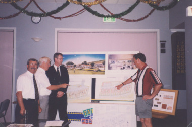
Photograph - Golf Houses residential development Golf Links Road Lakes Entrance Victoria 1999, Lakes Post Newspaper
... Golf Houses residential development Golf Links Road Lakes Entrance Victoria 1999...Golf Houses residential development Golf Links Road Lakes Entrance Victoria - Proposed plan shown on notice board...Colour photograph showing Matt Martino Bill Daniel Mike Hurst and Gary Jeal at the launch of Golf Houses residential development Golf Links Road Lakes Entrance Victoria...Golf Houses residential development Golf Links Road Lakes Entrance Victoria - Proposed plan shown on notice board Tourism Land Development Colour photograph showing Matt Martino Bill Daniel Mike Hurst and Gary Jeal at the launch of Golf Houses residential development Golf Links Road Lakes Entrance Victoria Photograph Golf Houses residential development Golf Links Road Lakes Entrance Victoria 1999 Lakes Post Newspaper ...Golf Houses residential development Golf Links Road Lakes Entrance Victoria - Proposed plan shown on notice boardColour photograph showing Matt Martino Bill Daniel Mike Hurst and Gary Jeal at the launch of Golf Houses residential development Golf Links Road Lakes Entrance Victoriatourism, land development -
 Greensborough Historical Society
Slide - Photograph, John Ramsdale, Residential development, Whittlesea: Slide 68, 1990s
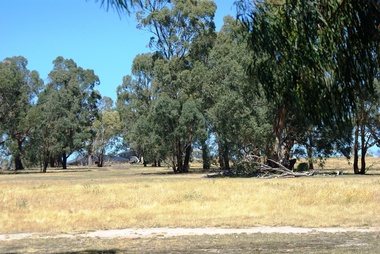
... Residential development, Whittlesea: Slide 68...residential development...Photograph shows a residential development in Whittlesea....Greensborough Historical Society 34A Glenauburn Road Lower Plenty Lower Plenty melbourne Photograph shows a residential development in Whittlesea. Part of the John Ramsdale collection of slides and audio visual material. residential development whittlesea No maker's marks. ...Photograph shows a residential development in Whittlesea.Part of the John Ramsdale collection of slides and audio visual material.Colour photograph scanned from slide.No maker's marks. No caption on slide.residential development, whittlesea -
 Greensborough Historical Society
Slide - Photograph, John Ramsdale, Residential development south of Whittlesea: Slide 92, 1990s
... Residential development south of Whittlesea: Slide 92......residential development...Photograph shows residential development south of Whittlesea encroaching on farmland....Greensborough Historical Society 34A Glenauburn Road Lower Plenty Lower Plenty melbourne Photograph shows residential development south of Whittlesea encroaching on farmland. ...Photograph shows residential development south of Whittlesea encroaching on farmland.Part of the John Ramsdale collection of slides and audio visual material.Colour photograph scanned from slide.No maker's marks. No caption on slide.whittlesea, residential development -
 Sunshine and District Historical Society Incorporated
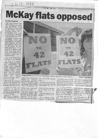
Archive - Sunshine Housing Heritage Study & opposition to the residential development of part of Sunshine Technical School
... Sunshine Housing Heritage Study & opposition to the residential development of part of Sunshine Technical School...Newspaper articles re the Sunshine Heritage Study and the proposed conversion of the former Sunshine Technical School's McKay metal trades wing to a residential development...Sunshine Housing Heritage Study|Newspaper Article 23 November 1999 McKay flats opposed Newspaper articles re the Sunshine Heritage Study and the proposed conversion of the former Sunshine Technical School's McKay metal trades wing to a residential development Archive Sunshine Housing Heritage Study & opposition to the residential development of part of Sunshine Technical School ...Newspaper Article Sunshine Advocate 7 July 1993 30000 jump by 2010 demolishing and rebuilding parts of Braybrook and Maidstone will raise the population of the City of Sunshine over the next 20 years. Sunshine Housing Heritage Study|Newspaper Article 23 November 1999 McKay flats opposedsunshine technical school, sunshine, dunstone, morris street, sunshine technical school trade building -
 Lakes Entrance Historical Society
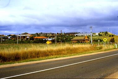
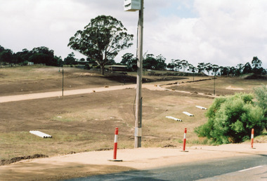
Photograph - Residential development Swan Reach Victoria 2006, Holding M, 2006
... Residential development Swan Reach Victoria 2006...Colour photograph of early stage of residential development showing roadways formed through property, drainage pipes placed ready for installation, street lighting in place. ...Swan Reach Victoria Photograph Residential development Swan Reach Victoria 2006 Holding M ...Property and subdivision believed to have been done by Bill and Kaye Reddenbach.Colour photograph of early stage of residential development showing roadways formed through property, drainage pipes placed ready for installation, street lighting in place. Photograph taken from school, looking east. Swan Reach Victorialand development, housing -
 Ringwood and District Historical Society
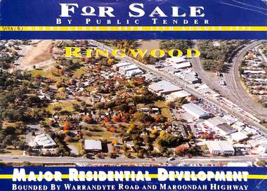
Flyer, Residential Development Sale by Public Tender, Ringwood, Victoria - 1993
... Residential Development Sale by Public Tender, Ringwood, Victoria - 1993...Double-sided brochure with map advertising major residential development bounded by Warrandyte Road and Maroondah Highway, Ringwood. ...Residential Development Sale by Public Tender, Ringwood, Victoria - 1993 Flyer ...Double-sided brochure with map advertising major residential development bounded by Warrandyte Road and Maroondah Highway, Ringwood. Seven allotments facing Aird Street, Pratt Street, Bardia Street, Larissa Avenue and Suda Avenue offered as a whole or separately. Total land 30,900 square metres. Lots 3 to 7 have plans available for 207 units. Tenders close 5pm 12th August 1993. Agents - Michael Lewin, Simon Conquest, Talbot Birner Morley, 191 Balaclava Road Caulfield North (Tel) 5259222. -
 Eltham District Historical Society Inc
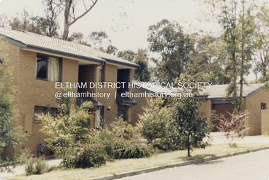
Photograph - Colour Print, Unidentified residential development, Eltham District, c.1985
... Unidentified residential development, Eltham District......residential development...Eltham District Historical Society Inc 728 Main Rd Eltham melbourne Batch 4 Eltham district residential development Colour print 10 x 15 cm Originally housed in a 34.5 x 36 x 2.5 cm expandable album with padded cream covers and gold accents; 18 page inserts with clear pocket inserts holding 6 photos per side, total capacity 216 10 x 15 cm photo prints; showing yellowing with age Unidentified residential development, Eltham District Photograph Colour Print ...batch 4, eltham district, residential development -
 Eltham District Historical Society Inc
Photograph - Colour Print, Unidentified residential development, Eltham District, c.1986
... Unidentified residential development, Eltham District...residential development...Eltham District Historical Society Inc 728 Main Rd Eltham melbourne residential development Marked "6" Colour print 10 x 15 cm Originally housed in a 34.5 x 36 x 2.5 cm expandable album with padded cream covers and gold accents; 18 page inserts with clear pocket inserts holding 6 photos per side, total capacity 216 10 x 15 cm photo prints; showing yellowing with age Unidentified residential development, Eltham District Photograph Colour Print ...Marked "6"residential development -
 Eltham District Historical Society Inc
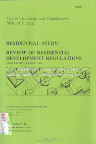
Document - Book, Econsult Planning and Development Pty Ltd, Residential Study: Review of Residential Development Regulations; Final Report; Volumes 1 and 2, October 1991
... Residential Study: Review of Residential Development Regulations; Final Report; Volumes 1 and 2...residential development...*To determine the housing types and lot sizes, required by new residents in different locations residential development Housing Two A4 bound volumes with green coloured face sheets and clear plastic covers. ...Report by Consultants Econsult Planning & Development produced under the Steering Committee guidance of the City of Doncaster and Templestowe and the Shire of Eltham recognising a lack of diversity in housing stock to meet changing housing needs. The Study objectives are: *To provide for a wide variety of housing choices and lot sizes *To make housing more accessible taking into account the Australian Model Code *To maintain residnetial amenity by taking into account significant local features *To prepare guidelines and policities which consider slope, lot, size, location, availability of services and significant vegeation. *To determine the housing types and lot sizes, required by new residents in different locationsresidential development, housing -
 Whitehorse Historical Society Inc.
Pamphlet, Multi Unit Residential Development Controls, 1/03/1986
... Multi Unit Residential Development Controls...Review of Multi Unit Residential Development controls: your chance to comment including present and proposed density zone maps....Multi Unit Residential Development Controls Pamphlet Pamphlet ...Review of Multi Unit Residential Development controls: your chance to comment including present and proposed density zone maps.land use, city of nunawading -
 Ringwood and District Historical Society
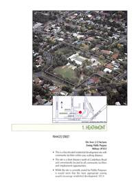
Document - Advertisement, Sale by Tender - Residential Development Site - Frances Street, Heathmont, Victoria - 1999
... Sale by Tender - Residential Development Site - Frances Street, Heathmont, Victoria - 1999...(Subsequent residential development of Skyline Place, Heathmont.)...(Subsequent residential development of Skyline Place, Heathmont.) ...2-page extract from booklet advertising development sites for sale by tender under instructions from the Education Department of Victoria. Includes aerial view and location map of former Heathmont Primary School site. (Subsequent residential development of Skyline Place, Heathmont.)Tenders close 12:00 noon on Wednesday 5th May, 1999. Agents - Colliers Jardine - William Carew 0412 539 717; Peter Bremner 0412 326 942. -
 Greensborough Historical Society
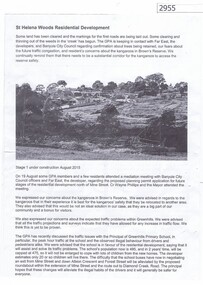
Article, Greenhills Progress Association, St Helena Woods Residential Development, 19/08/2015
... St Helena Woods Residential Development...Concerns by the Greenhills Progress Association and residents about the St Helena Woods residential development by Far East....Greensborough Historical Society 34A Glenauburn Road Lower Plenty Lower Plenty melbourne Concerns by the Greenhills Progress Association and residents about the St Helena Woods residential development by Far East. st helena woods greenhills progress associatiion One page, text and photograph St Helena Woods Residential Development Article Greenhills Progress Association ...Concerns by the Greenhills Progress Association and residents about the St Helena Woods residential development by Far East.One page, text and photograph st helena woods, greenhills progress associatiion -
 Greensborough Historical Society
Photograph - Digital image, Marilyn Smith et al, Janefield Precinct: Looking towards the future - new residential development, 27/11/2014
... Janefield Precinct: Looking towards the future - new residential development....Janefield Precinct: Looking towards the future - new residential development. The remains of this site are between Greensborough and Janefield. ...Janefield Precinct: Looking towards the future - new residential development. Photograph - Digital image Marilyn Smith Norm Colvin ...Janefield Precinct: Looking towards the future - new residential development. The remains of this site are between Greensborough and Janefield. A RAAF Hygiene Training Camp was located on the Plenty River, just south of the Janefield community. It was in use from 1944 to 1946. The Camp was constructed from salvaged materials. Instruction included building and maintenance of grease traps, latrines, elementary plumbing and carpentry.Early remains of a WW2 training camp Digital colour photograph.janefield -
Whitehorse Historical Society Inc.
Document, Winlaton, 1/11/2008 12:00:00 AM
... ...Residential development...The Building was demolished in the early 1990s for residential development....The Building was demolished in the early 1990s for residential development....The Building was demolished in the early 1990s for residential development. Winlaton Youth Training Centre Residential development Short history of 'Winlaton', a grand home built by J. ...Short history of 'Winlaton', a grand home built by J. T. Tweddle in 1909.Short history of 'Winlaton', a grand home built by J. T. Tweddle in 1909. The property was later converted to an institution for girls named 'Winlation Youth Training Centre'. The Building was demolished in the early 1990s for residential development.Short history of 'Winlaton', a grand home built by J. T. Tweddle in 1909. winlaton youth training centre, residential development -
Glen Eira Historical Society
Document - RESIDENTIAL DEVELOPMENT POST AUGUST 2013 IN GLEN EIRA
... RESIDENTIAL DEVELOPMENT POST AUGUST 2013 IN GLEN EIRA...Glen Eira Historical Society 965 Glen Huntly Rd Caulfield VIC 3162 melbourne This file has folder A only awaiting checking Document RESIDENTIAL DEVELOPMENT POST AUGUST 2013 IN GLEN EIRA ...This file has folder A only awaiting checking -
Port Melbourne Historical & Preservation Society
Photograph - Port Melbourne residential development 1996, Ron Laing, 1988 - 1999
... Port Melbourne residential development 1996...View looking East from Princes Pier in June 1996 showing Port Melbourne residential redevelopment underway Photograph Port Melbourne residential development 1996 Ron Laing ...Part of Ron Laing's collection of photographs recording Port Melbourne over a thirteen year period. Donated to the PMH&PS by the photographer.One of a set of 20 colour photographs 1980s-90s, of various events and subjects. View looking East from Princes Pier in June 1996 showing Port Melbourne residential redevelopment underwayron laing -
Ballarat Tramway Museum
Plan - Map of Greater Ballarat Residential Development. c1949, State Electricity Commission of Victoria (SECV), c1949
... Map of Greater Ballarat Residential Development. c1949...Plan Map of Greater Ballarat Residential Development. c1949 State Electricity Commission of Victoria (SECV) ...Map representation of the greater Ballarat area 1949. Created by the State Electricity Commission of Victoria (SECV), State Electricity Supply Department, Ballarat Branch.Map template used to create planning documents with association to the "Report by Hector H Bell Jnr of the Melbourne and Metropolitan Tramways Board, on the street passenger transport system of Ballaarat Urban Area".A2 map template. Scale 1 inch = 20 chain. Copy of hand drawn document. Black dye line print on beige paper.map, roads, secv, state electricity commission of victoria, ballarat, ballarat tramways, transport, planning -
Ballarat Tramway Museum
Plan - Map of Greater Ballarat Residential Development. c1949, State Electricity Commission of Victoria (SECV), c1949
... Map of Greater Ballarat Residential Development. c1949...Plan Map of Greater Ballarat Residential Development. c1949 State Electricity Commission of Victoria (SECV) ...Map representation of the greater Ballarat area 1949. Created by the State Electricity Commission of Victoria (SECV), State Electricity Supply Department, Ballarat Branch.Map template used to create planning documents with association to the "Report by Hector H Bell Jnr of the Melbourne and Metropolitan Tramways Board, on the street passenger transport system of Ballaarat Urban Area".A2 map template. Scale 1 inch = 20 chain. Copy of hand drawn document. Black dye line print on beige paper. Residential, Industrial, Schools and Business areas hand drawn on print.TBDmap, roads, secv, state electricity commission of victoria, ballarat, ballarat tramways, transport, planning -
Ballarat Tramway Museum
Plan - Map of Greater Ballarat Residential Development. c1949, State Electricity Commission of Victoria (SECV), c1949
... Map of Greater Ballarat Residential Development. c1949...Plan Map of Greater Ballarat Residential Development. c1949 State Electricity Commission of Victoria (SECV) ...Map representation of the greater Ballarat area 1949. Created by the State Electricity Commission of Victoria (SECV), State Electricity Supply Department, Ballarat Branch.Map template used to create planning documents with association to the "Report by Hector H Bell Jnr of the Melbourne and Metropolitan Tramways Board, on the street passenger transport system of Ballaarat Urban Area".A2 map template. Scale 1 inch = 20 chain. Copy of hand drawn document. Black dye line print on beige paper.map, roads, secv, state electricity commission of victoria, ballarat, ballarat tramways, transport, planning -
Ballarat Tramway Museum
Plan - Map of Greater Ballarat Residential Development. c1949, State Electricity Commission of Victoria (SECV), c1949
... Map of Greater Ballarat Residential Development. c1949...Plan Map of Greater Ballarat Residential Development. c1949 State Electricity Commission of Victoria (SECV) ...Map representation of the greater Ballarat area 1949. Created by the State Electricity Commission of Victoria (SECV), State Electricity Supply Department, Ballarat Branch.Map template used to create planning documents with association to the "Report by Hector H Bell Jnr of the Melbourne and Metropolitan Tramways Board, on the street passenger transport system of Ballaarat Urban Area".A2 map template. Scale 1 inch = 20 chain. Copy of hand drawn document. Black dye line print on beige paper. Tram and Bus routes hand drawn on print.The words "SAMPLE" and "Office Copy" written above title block of document in pencil. Print mark "P.E. 2.1" on top left corner of document. Ballarat tramway location marked in orange marker. Bus routes shown in brown, green, and blue.map, roads, secv, state electricity commission of victoria, ballarat, ballarat tramways, transport, planning -
Whitehorse Historical Society Inc.
Document, Whitehorse, 1/04/1998 12:00:00 AM
... ...Residential Development...Municipal fact sheet series- residential development....Whitehorse Historical Society Inc. 2-10 Deep Creek Road Mitcham melbourne City of Whitehorse Residential Development Whitehorse key facts. Municipal fact sheet series- residential development. ...Whitehorse key facts. Municipal fact sheet series- residential development.Whitehorse key facts. Municipal fact sheet series- residential development.Whitehorse key facts. Municipal fact sheet series- residential development.city of whitehorse, residential development -
Save the Dandenongs League Inc.
Archive (item), Save the Dandenongs League Incorporated, Upper Yarra Valley and Dandenong Ranges Authority - Technical Report Series - Report No. 8 - 1989 - Transport Issues Relating to Residential Development in the Region
... Upper Yarra Valley and Dandenong Ranges Authority - Technical Report Series - Report No. 8 - 1989 - Transport Issues Relating to Residential Development in the Region...Upper Yarra Valley and Dandenong Ranges Authority - Technical Report Series - Report No. 8 - 1989 - Transport Issues Relating to Residential Development in the Region Archive Save the Dandenongs League Incorporated ... -
Save the Dandenongs League Inc.
Archive (item), Save the Dandenongs League Incorporated, Upper Yarra Valley and Dandenong Ranges Authority - Technical Report Series - Report No. 4 - 1988 - Capacity for Additional Residential Development in the Upper Yarra Valley and Dandenong Ranges Region as at 31st March, 1988
... Upper Yarra Valley and Dandenong Ranges Authority - Technical Report Series - Report No. 4 - 1988 - Capacity for Additional Residential Development in the Upper Yarra Valley and Dandenong Ranges Region as at 31st March, 1988...Upper Yarra Valley and Dandenong Ranges Authority - Technical Report Series - Report No. 4 - 1988 - Capacity for Additional Residential Development in the Upper Yarra Valley and Dandenong Ranges Region as at 31st March, 1988 Archive Save the Dandenongs League Incorporated ... -
Save the Dandenongs League Inc.
Archive (item), Save the Dandenongs League Incorporated, Upper Yarra Valley and Dandenong Ranges Authority - Technical Report Series - Report No. 20 - 1988 - Rural Residential Development Development Issues Paper
... Upper Yarra Valley and Dandenong Ranges Authority - Technical Report Series - Report No. 20 - 1988 - Rural Residential Development Development Issues Paper...Upper Yarra Valley and Dandenong Ranges Authority - Technical Report Series - Report No. 20 - 1988 - Rural Residential Development Development Issues Paper Archive Save the Dandenongs League Incorporated ... -
Save the Dandenongs League Inc.
Archive (item), Save the Dandenongs League Incorporated, Land Constraints to Residential Development in the Upper Yarra Valley and Dandenong Ranges Region - Landscape Living Policy Area
... Land Constraints to Residential Development in the Upper Yarra Valley and Dandenong Ranges Region - Landscape Living Policy Area...Upper Yarra Valley and Dandenong Ranges Authority (UYVDRA) Land Constraints to Residential Development in the Upper Yarra Valley and Dandenong Ranges Region - Landscape Living Policy Area Archive Save the Dandenongs League Incorporated ...upper yarra valley and dandenong ranges authority (uyvdra) -
Whitehorse Historical Society Inc.
Article, Whitehorse vision for Healesville, 2014
... To include open space, sustained natural environment and some residential development covering 19% of the land....City of Whitehorse Vision for Healesville Freeway Reservation to include open space, sustained natural environment and some residential development covering 19% of the land....City of Whitehorse Vision for Healesville Freeway Reservation to include open space, sustained natural environment and some residential development covering 19% of the land. Whitehorse vision for Healesville Article Article ...City of Whitehorse Vision for Healesville Freeway Reservation.City of Whitehorse Vision for Healesville Freeway Reservation to include open space, sustained natural environment and some residential development covering 19% of the land.City of Whitehorse Vision for Healesville Freeway Reservation.healesville freeway reservation, city of whitehorse -
 Greensborough Historical Society
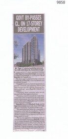
Newspaper - Newspaper Clipping, The Local Paper, Govt By-Passes Cl. on 17 Story Development, 28/05/2025
... ...residential development...Banyule City Council Victorian State Goverment main street greensborough residential development residential planning Newspaper clipping with black text and colour photo. ...Article about the approval of a 17-storey apartment building at 106 Main Street, Greensborough, by the State Government, and acording to Council, by-passing the City of Banyule.Newspaper clipping with black text and colour photo.banyule city council, victorian state goverment, main street greensborough, residential development, residential planning -
 Eltham District Historical Society Inc
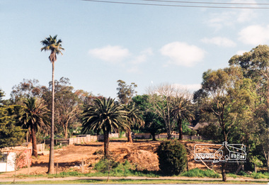
Photograph, Site development, Main Road, Eltham East, 1995, 1995
... Two colour photographs of construction of residential development on site of former house and garden Main Road, Eltham East...Eltham District Historical Society Inc 728 Main Rd Eltham melbourne main road eltham east land development trees Two colour photographs of construction of residential development on site of former house and garden Main Road, Eltham East Site development, Main Road, Eltham East, 1995 Photograph ...Two colour photographs of construction of residential development on site of former house and garden Main Road, Eltham Eastmain road, eltham east, land development, trees