Showing 4 items matching "rifle range road track"
-
 Eltham District Historical Society Inc
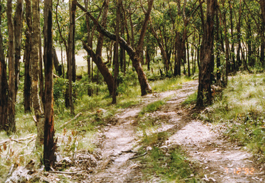
Photograph, Rifle Range Road Track near Buttermans Track, St Andrews, 7 December 1992, 07/12/1992
... Rifle Range Road Track near Buttermans Track, St Andrews, 7 December 1992......rifle range road track...Eltham District Historical Society Inc 728 Main Rd Eltham melbourne The Eltham Horse Trail: Research and Warrandyte to Kinglake: Survey of proposed route, December 1992: (3) Kangaroo Ground to Kinglake eltham horse trail (1992 survey) buttermans track rifle range road track st andrews Colour photograph Rifle Range Road Track near Buttermans Track, St Andrews, 7 December 1992 Photograph ...The Eltham Horse Trail: Research and Warrandyte to Kinglake: Survey of proposed route, December 1992: (3) Kangaroo Ground to KinglakeColour photographeltham horse trail (1992 survey), buttermans track, rifle range road track, st andrews -
 Eltham District Historical Society Inc
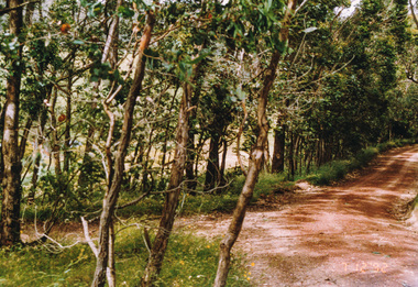
Photograph, Track to Rifle Range Road off Fox Road, Smiths Gully, 7 December 1992, 07/12/1992
... Track to Rifle Range Road off Fox Road, Smiths Gully, 7 December 1992...Eltham District Historical Society Inc 728 Main Rd Eltham melbourne The Eltham Horse Trail: Research and Warrandyte to Kinglake: Survey of proposed route, December 1992: (3) Kangaroo Ground to Kinglake eltham horse trail (1992 survey) smiths gully fox road rifle range road Two colour photographs Track to Rifle Range Road off Fox Road, Smiths Gully, 7 December 1992 Photograph ...The Eltham Horse Trail: Research and Warrandyte to Kinglake: Survey of proposed route, December 1992: (3) Kangaroo Ground to KinglakeTwo colour photographseltham horse trail (1992 survey), smiths gully, fox road, rifle range road -
 Stawell Historical Society Inc
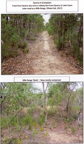
Photograph, A Track into Grampians Quarry -- Previously a Railway Line & Rifle Range Taken 2017 -- 2 Photos -- Coloured
... Two colour photographs of Track into Quarry Road Grampians. Once Rail Line used in construction of dam wall, later used as rifle range. ...Stawell Historical Society Inc 46 Longfield St Stawell grampians Two colour photographs of Track into Quarry Road Grampians. Once Rail Line used in construction of dam wall, later used as rifle range. ...Two colour photographs of Track into Quarry Road Grampians. Once Rail Line used in construction of dam wall, later used as rifle range. The rifle range was once the last part of the railway track that ran to the quarry which was used to cart stone to Lake Fyans when it was being constructed. (1912-1918). The rifle butts are near to or part of the quarry. The Rifle range can still be seen. Two colour photographs of bush setting with track and dirt mound (rifle butts)stawell -
 Peterborough History Group
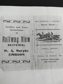
Booklet - Race Card, Port Campbell and District Race Club Annual Meeting Monday 8th February 1926
... Peterborough History Group Peterborough great-ocean-road Race programme for horse racing event at the Port Campbell race track, located near Two Mile Bay, where the rifle range is now located. ...Race programme for horse racing event at the Port Campbell race track, located near Two Mile Bay, where the rifle range is now located. Lists horses and owners. Includes advertising for local businesses at the time.Significant as it indicates sporting and social activities in 1926. Photocopy of original race programme at the Port Campbell Racetrack.port campbell horse racing, port campbell race track, railway view hotel timboon, port campbell hotel, cobden hotel, 1926