Showing 12 items matching "rising flood"
-
 Victorian Harness Racing Heritage Collection at Lord's Raceway Bendigo
Document - Record, Harness Horse, Rising Flood
... Rising Flood......rising flood...Rising Flood Document Record, Harness Horse ...Stephen Spark compiled horses performance records starting in 1983 on his typewriter. Rising Flood raced from 1959 (2yo) through to 1967 (10yo). Career: 36 wins 20 seconds 19 thirds 116 starts.Typed document in black and red ink.harness racing, australasian harness racing, horse career, performance records, bendigo harness racing club, bhrc, rising flood, bh clarke, sv rothacker -
 Charlton Golden Grains Museum Inc
Photograph - B/W Photograph of 1973 flood near Gordon Park, 1973 Flood, c. Feb 1973
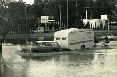
... Campers forced out of Gordon Park by rising flood waters c.1973...Campers forced out of Gordon Park by rising flood waters c.1973 Gordon Park Charlton Floods Unframed B/W photograph 1973 Flood Photograph B/W Photograph of 1973 flood near Gordon Park Cameron, Ian Cameron, Ian Charlton Tribune ...1973 flood near Gordon Park, Car and caravan driving through flood water and road followed by two bicycles. Campers forced out of Gordon Park by rising flood waters c.1973Unframed B/W photograph gordon park, charlton, floods -
 Bendigo Historical Society Inc.
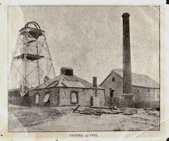
Photograph - VICTORIA QUARTZ - NEW CHUM LINE OF REEF, c.1890
... On the night of June 14th, 1910, the mine was flooded out by the rising waters from the deep New Chum mines to the south, all of which had either ceased operations or had returned back to shallow workings. ...On the night of June 14th, 1910, the mine was flooded out by the rising waters from the deep New Chum mines to the south, all of which had either ceased operations or had returned back to shallow workings. ...Black and white photograph. Poppet head on LH side, stone building, centre, tall brick chimney, RH side in front of timber building. Inscriptions: on front - 'Victoria Quartz'. On back - typewritten description as follows: 'Situated on the rich Victoria Hill, Ironbark. Steel girders? rams type poppet legs - 60ft high. Vertical winding engines; pair of 24' dia. Winding drums. Made and erected by Roberts & Sons, Bendigo, in 1897. Then one of the best in the state. In 1910 it was the deepest gold mine in the world, having reached a depth of 4,613 ft in the winze. The shaft was then sunk to a depth of 4,588 ft. in an endeavour to reach a depth of 4,870 ft. to effectively work the deepest gold bearing reef in the world. On the night of June 14th, 1910, the mine was flooded out by the rising waters from the deep New Chum mines to the south, all of which had either ceased operations or had returned back to shallow workings. For details of the mine's record, see 'The Historical Guide to Bendigo'. Mine details completed by A Richardson, 29 Harrison Street, Bendigo.place, mining site, victoria quartz -
 Bendigo Historical Society Inc.
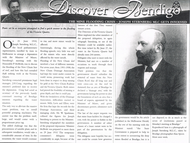
Newspaper - LONG GULLY HISTORY GROUP COLLECTION: THE MINE FLOODING CRISIS - VICTORIA QUARTZ
... flooding of the New Chum line of reef. Pumping was mentioned but it would be expensive and would take time and the water would keep rising. ...flooding of the New Chum line of reef. Pumping was mentioned but it would be expensive and would take time and the water would keep rising. ...Copy of an article in the Bendigo Weekly titled The Mine Flooding Crisis - Joseph Sternberg MLC gets involved by James Lerk. Joseph Sternberg MLC travelled to Melbourne to arrange a deputation with the Minister of Mines to discuss the flooding of the New Chum line of reef. Pumping was mentioned but it would be expensive and would take time and the water would keep rising. They would also have to find a suitable pumping plant. The New Chum Drainage Association had kept the water under control. Delegates wanted the Government to subsidise the removal of the water.bendigo, history, long gully history group, the long gully history group - bendigo weekly, james lerk, victoria quartz, joseph sternberg, the honorable p mcbride, j h craig, new chum reef, new chum drainage association, new chum railway, mills lavis and elliot, mr w sparkman, melbourne herald, alan spicer -
 Eltham District Historical Society Inc
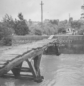
Album - Photograph, J.A. McDonald, Eltham-Greensborough Road, 18 Oct. 1956
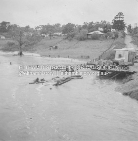
... Bridge Street Bridge Flood level on Greensborough pier 18th October 1956 View looking west across the Diamond Creek and tempoary walking access bridge towards intersection of Susan Street. The building visible on centreeline is the present-day SES facility. Beware!.. our rivers are rising...Eltham District Historical Society Inc 728 Main Rd Eltham melbourne Bridge Street Bridge Flood level on Greensborough pier 18th October 1956 View looking west across the Diamond Creek and tempoary walking access bridge towards intersection of Susan Street. The building visible on centreeline is the present-day SES facility. Beware!.. our rivers are rising ...Bridge Street Bridge Flood level on Greensborough pier 18th October 1956 View looking west across the Diamond Creek and tempoary walking access bridge towards intersection of Susan Street. The building visible on centreeline is the present-day SES facility. Beware!.. our rivers are rising (1956, October 19). The Argus (Melbourne, Vic. : 1848 - 1957), p. 1. Retrieved August 24, 2022, from http://nla.gov.au/nla.news-article84392304Record of various Shire of Eltham infrastructure works undertaken during the period of 1952-1962 involving bridge and road reconstruction projects, sometimes with Eltham Shire Council Project Reference numbers quoted. It was during this period that a number of significant improvements were made to roads and new bridges constructed within the shire that remain in place as of present day (2022). In many situations, the photos provide a tangible visible record of infrastructure that existed throughout the early days of the Shire. The album was put together by or under the direction of the Shire Engineer, J.A. McDonald.infrastructure, road construction, shire of eltham, bridge construction, bridge street bridge, eltham, eltham-greensborough road, 1956-10-18, diamond creek (creek), floods, floodwater, silver street bridge -
 Eltham District Historical Society Inc
Album - Photograph, J.A. McDonald, Eltham-Greensborough Road, 18 Oct. 1956
... Bridge Street Bridge Flooding on Waterfall’s Estate 18th October 1956 Looking east up to Main Road over what is now present-day Alistair Knox Park Beware!.. our rivers are rising...Eltham District Historical Society Inc 728 Main Rd Eltham melbourne Bridge Street Bridge Flooding on Waterfall’s Estate 18th October 1956 Looking east up to Main Road over what is now present-day Alistair Knox Park Beware!.. our rivers are rising ...Bridge Street Bridge Flooding on Waterfall’s Estate 18th October 1956 Looking east up to Main Road over what is now present-day Alistair Knox Park Beware!.. our rivers are rising (1956, October 19). The Argus (Melbourne, Vic. : 1848 - 1957), p. 1. Retrieved August 24, 2022, from http://nla.gov.au/nla.news-article84392304Record of various Shire of Eltham infrastructure works undertaken during the period of 1952-1962 involving bridge and road reconstruction projects, sometimes with Eltham Shire Council Project Reference numbers quoted. It was during this period that a number of significant improvements were made to roads and new bridges constructed within the shire that remain in place as of present day (2022). In many situations, the photos provide a tangible visible record of infrastructure that existed throughout the early days of the Shire. The album was put together by or under the direction of the Shire Engineer, J.A. McDonald.infrastructure, road construction, shire of eltham, bridge construction, bridge street bridge, eltham, eltham-greensborough road, 1956-10-18, diamond creek (creek), floods, floodwater, silver street bridge, alistair knox park, waterfall property -
 Eltham District Historical Society Inc
Album - Photograph, J.A. McDonald, Eltham-Greensborough Road, 18 Oct. 1956
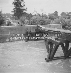
... Bridge Street Bridge Flood level on Eltham pier 18th October 1956 Looking west across the Diamond Creek to Susan Street intersection Beware!.. our rivers are rising...Eltham District Historical Society Inc 728 Main Rd Eltham melbourne Bridge Street Bridge Flood level on Eltham pier 18th October 1956 Looking west across the Diamond Creek to Susan Street intersection Beware!.. our rivers are rising ...Bridge Street Bridge Flood level on Eltham pier 18th October 1956 Looking west across the Diamond Creek to Susan Street intersection Beware!.. our rivers are rising (1956, October 19). The Argus (Melbourne, Vic. : 1848 - 1957), p. 1. Retrieved August 24, 2022, from http://nla.gov.au/nla.news-article84392304Record of various Shire of Eltham infrastructure works undertaken during the period of 1952-1962 involving bridge and road reconstruction projects, sometimes with Eltham Shire Council Project Reference numbers quoted. It was during this period that a number of significant improvements were made to roads and new bridges constructed within the shire that remain in place as of present day (2022). In many situations, the photos provide a tangible visible record of infrastructure that existed throughout the early days of the Shire. The album was put together by or under the direction of the Shire Engineer, J.A. McDonald.infrastructure, road construction, shire of eltham, bridge construction, bridge street bridge, eltham, eltham-greensborough road, 1956-10-18, diamond creek (creek), floods, floodwater, silver street bridge -
 Sunshine and District Historical Society Incorporated
Document - Brimbank Rising, Tony Smith, 2018
... Postwar flooding of the Harvester Works, and of the region with migrants, demanded major infrastructure investment and municipal capabilities which were consistent with wider suburbanisation and growing dominance of road transport without challenging the area’s politically safe status. The penultimate section is focused on concurrent events in 2009 and how they play out through council in administration’s Sunshine Rising...Postwar flooding of the Harvester Works, and of the region with migrants, demanded major infrastructure investment and municipal capabilities which were consistent with wider suburbanisation and growing dominance of road transport without challenging the area’s politically safe status. The penultimate section is focused on concurrent events in 2009 and how they play out through council in administration’s Sunshine Rising ...The suburban municipality of Brimbank is strategically located across key transport corridors serving Melbourne’s rapid western and northwestern expansion. Brimbank Rising steps through local prehistory and history with attention to planning events from Hoddle’s 1840 survey to the recent Regional Rail Link which shape the area. Across five periods, this history sees planning as a contributory process to city shaping, with specific plans as snapshots in time of endorsed intentions, all through the lens of complexity, connectedness and contingency. Recent geological and ecological history had been productively harnessed by the Wurundjeri before all were disrupted by the arrival of unauthorised settlers from Tasmania and their livestock focused on serving markets in and using methods more appropriate to the other side of the world. Following colonial separation and the discovery of gold in 1851, the second part follows the expansion of heavy rail and the multifaceted influence of leading industrialist H V McKay’s Sunshine Harvester Works through and between the booms of the 1880s and 1920s. Postwar flooding of the Harvester Works, and of the region with migrants, demanded major infrastructure investment and municipal capabilities which were consistent with wider suburbanisation and growing dominance of road transport without challenging the area’s politically safe status. The penultimate section is focused on concurrent events in 2009 and how they play out through council in administration’s Sunshine Rising campaign to capitalise on the local potential of Sunshine’s rail upgrade and complementary infrastructure investments. Finally, there is discussion of current state policies and planning which relate to Brimbank and which the council and community need to continue to work with and advocate for further Rising to ensure Brimbank’s potential as service corridor for the Growth Areas is realised.Brimbank Rising From a History of Failed Local Councils, Officers and Administrators Promote and Support Sunshine Risingaboriginal, first nation, h.v. mckay, sunshine harvester factory -
 Kew Historical Society Inc
Photograph, Marnie McLeod, Floods of the River Yarra at Kew, 1916
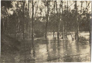
... Black and white photograph of flooded trees in Kew with rising dry ground in distance....Together with our original MMBW River Yarra map showing flood levels, these items, when compared allow researchers to gain a visual perspective of the extent of the flood in 1916. river yarra kew floods 1916 Inscription on reverse in pencil: "Flood River Yarra Kew Vic" Black and white photograph of flooded trees in Kew with rising dry ground in distance. ...The donation was accompanied by the following letter from the donor: "Hi. I found these in with family photos. Taken by family as Mamie McLeod was living in Fellows Street, Kew, so would be near there. Retain (or discard) as you see fit." [Donor's name and address withheld from public view]. To gain an insight into the flood levels at Kew, it is worth reading newspaper accounts of the event. The Age published an article - Valuable Gardens Destroyed at Kew - on 25 September 1916: "VALUABLE GARDENS DESTROYED AT KEW. From the heights of Studley Park, Kew, a splendid view of the flood waters can be obtained, and yesterday afternoon, despite continuous rain, crowds of citizens assembled there to witness the spectacle. There is a vast stretch of water some 300 or 400 yards broad, above the foot bridge connecting Gipps-street, Collingwood, and Studley Park. The river is only about 3 feet from the top of the embankment connecting with the ramp of the bridge on the Studiey Park side. When the upper llood waters come down it is almost a certainty that tne embankment will be submerged and the bridge rendered impassible. Below the bridge the waters again stretch out, and have submerged all the low-lying land on the Collingwood side and invaded the back premises ot the Kodak Co., Phoenix Biscuit Factory, a tannery adjoining thereto, the Shamrock Brewery, and Chinese gardens in the vicinity. At Walmer-street-bridge, at the end of Studley Park, the low-lying land on the Kew side is covered with water to the depth of many feet. Tlie land in question is owned in a great part by Mr Frank Lavers who haa gone in for intense culture on a pretty liberal scale on both the slopes of the hill and on the river flat. On the latter he is cultivating many acres of asparagus, and has at a considerable cost spent three years in preparing the ground and installing an irrigation system, reticulated from the Yan Yean water supply. This year the asparagus was put down, and the plants were in a promising condition. Tlie flood waters are now flowing fast over the land. The crop is ruined, and three years' work and expenditure destroyed. Mr. Laver's private residence fortunately is high above flood level, but two houses he owns off Young-street have been flooded out. Having been warned in time, the tenants removed their furniture hefore the water came down to Mr. Laver's residence, where they themselves have been given accommodation in the meantime. All the river flats in East Kew are under water. One or two low-lying houses have been flooded. Chipperfield's boat shed at Willsmere is nearly covered, and some Chinese gardens in the vicinity are several feet under water."This, and the other three photographs donated of floods in Kew are believed to be the earliest in the collection. Together with our original MMBW River Yarra map showing flood levels, these items, when compared allow researchers to gain a visual perspective of the extent of the flood in 1916. Black and white photograph of flooded trees in Kew with rising dry ground in distance.Inscription on reverse in pencil: "Flood River Yarra Kew Vic"river yarra, kew, floods 1916 -
 Wodonga & District Historical Society Inc
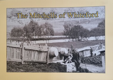
Book - The Mitchells of Whiteford, Paul Mitchell, 2020
... flooding of the valley by the construction of the Hume Weir. Mitta Mitta history Mitchell family history Whiteford Mitta Mitta Valley "Whiteford is a mystical place. A small farm in north-east Victoria, rising ..."Whiteford is a mystical place. A small farm in north-east Victoria, rising from the rich flats of the Mitta Mitta River a few kilometres upstream from its confluence with the mighty Murray River. Taken up in 1879 from the large Bethanga run, Whiteford was home to the Mitchell family until it was flooded by the Hume Weir around 1934. Through this collection of family photos and small stories, we might glimpse something of family and farming in the fertile Mitta Mitta Valley before it was flooded by the Hume Weir" - Paul Mitchell, author.A family history of the Mitchell family of Whiteford, Victoria. This publication includes stories and many black and white images of the Mitchell family and their home."Whiteford is a mystical place. A small farm in north-east Victoria, rising from the rich flats of the Mitta Mitta River a few kilometres upstream from its confluence with the mighty Murray River. Taken up in 1879 from the large Bethanga run, Whiteford was home to the Mitchell family until it was flooded by the Hume Weir around 1934. Through this collection of family photos and small stories, we might glimpse something of family and farming in the fertile Mitta Mitta Valley before it was flooded by the Hume Weir" - Paul Mitchell, author.mitta mitta history, mitchell family history, whiteford mitta mitta valley -
 8th/13th Victorian Mounted Rifles Regimental Collection
Photograph
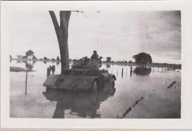
... Rising Sun badge. ' 1956 Staghound Armoured Car settling. Exercise in Chiltern/ Rutherglen area. " Black and white photograph of Staghound Armoured Car wheel-hub deep in flood water Photograph ...The 8th/13th Victorian Mounted Rifles was raised as a regiment of the Royal Australian Armoured Corps on 1 May 1948 with Headquarters in Melbourne and squadrons in Sale, Benalla/Wangaratta and Albury. In 1955 Regimental Headquarters moved to Wangaratta and a second squadron was located at Albury. The Sale squadron transferred to 4th/19th Prince of Wales’s Light Horse. In 1977 8/13 VMR Regiment was reduced to an independent squadron A Squadron 8th/13th Victorian Mounted Rifles and in 1991 was linked with 4th/19th Prince of Wales’s Light Horse forming the VMR Squadron of that regiment.Collection of photographs showing early evolution of an armoured regiment of the Citizen Forces as it progressed from WWII equipment and uniforms to post-war equipment and uniforms. Silver regimental hat badges are worn in place of Rising Sun badge.Black and white photograph of Staghound Armoured Car wheel-hub deep in flood water' 1956 Staghound Armoured Car settling. Exercise in Chiltern/ Rutherglen area. " -
 Kew Historical Society Inc
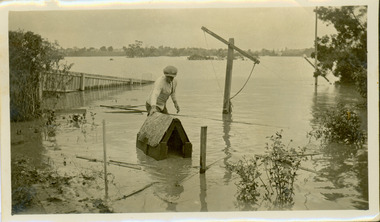
Photograph - Flooding of the Yarra River in North Kew, 1934
... Vivid photograph contrasting domestic life and relationships with natural disasters such as the flood of 1934. yarra river -- north kew floods -- yarra valley floods -- north kew floods -- 1934 natural disasters -- kew Verso: DAD SECURING NIPPY'S DOG KENNEL / Stamped 6414 Small sepia snapshot of the donors grandfather rescuing the family dog's kennel from rising floodwaters at the rear of 8 Kellett Grove, North Kew, . ...North Kew, now divided between Kew and Kew East, bordered the Yarra River. As such, it was a region subject to flooding in the Yarra Valley. Development beyond this point (ie Kellett Grove) was limited by the City of Kew's planning regulations. Prior to urban development, the area since European settlement and the first land sales in the district in the 1840s, had been used for dairy farming. Vivid photograph contrasting domestic life and relationships with natural disasters such as the flood of 1934.Small sepia snapshot of the donors grandfather rescuing the family dog's kennel from rising floodwaters at the rear of 8 Kellett Grove, North Kew, .Verso: DAD SECURING NIPPY'S DOG KENNEL / Stamped 6414yarra river -- north kew, floods -- yarra valley, floods -- north kew, floods -- 1934, natural disasters -- kew