Showing 202 items matching "river systems"
-
 Greensborough Historical Society
Map, The School Paper, Melbourne Water Supply Plan: showing the Yan Yean and Watts River Systems, 05/1899
... Melbourne Water Supply Plan: showing the Yan Yean and Watts River Systems...Map of Melbourne Water Supply Plan: showing the Yan Yean and Watts River Systems...Map of Melbourne Water Supply Plan: showing the Yan Yean and Watts River Systems the school paper MMBW melbourne water yan yean watts river maroondah aqueduct Black and white map laminated Melbourne Water Supply Plan: showing the Yan Yean and Watts River Systems Map Map The School Paper ...Map of Melbourne Water Supply Plan: showing the Yan Yean and Watts River SystemsBlack and white map laminatedthe school paper, mmbw, melbourne water, yan yean, watts river, maroondah aqueduct -
 Bendigo Historical Society Inc.
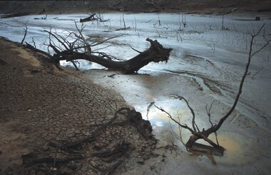
Slide - VAL DENSWORTH COLLECTION: DRY LAKE EPPALOCK, May 2004
... Mud pool in the River system....Mud pool in the River system. Slide VAL DENSWORTH COLLECTION: DRY LAKE EPPALOCK. ...Slide. Dry Lake Eppalock. Mud pool in the River system.slide, bendigo, dry lake eppalock., dry lake eppalock. -
 Federation University Historical Collection
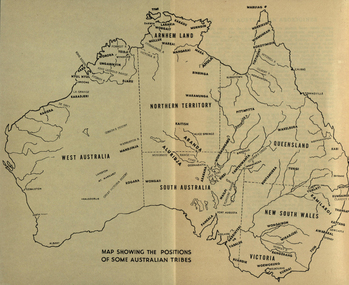
Map, Australia Showing Position of Some Australian Tribes, c1945, c1945
... Map of Australia showing states, river system and some Aboriginal Tribes....Elkin aboriginal aborigines kurnai worworung wongaibon wiradjuri dieri wakelbura pittapitta waramunga binbinga anula mara waral mulluk larakia worora djaru karadjerri kogara wongaii pankala tabalde buandie Map of Australia showing states, river system and some Aboriginal Tribes. Australia Showing Position of Some Australian Tribes, c1945 Map ...Digitised directly from "The Australian Aborigines: How to understand them" by A.P. ElkinMap of Australia showing states, river system and some Aboriginal Tribes.aboriginal, aborigines, kurnai, worworung, wongaibon, wiradjuri, dieri, wakelbura, pittapitta, waramunga, binbinga, anula, mara, waral, mulluk, larakia, worora, djaru, karadjerri, kogara, wongaii, pankala, tabalde, buandie -
Tatura Irrigation & Wartime Camps Museum
Booklet, Edmund D Gill, Rivers of History, 1970
... river systems...The series was produced in the Melbourne studios of the ABC by Ken Taylor river systems Beige cover. Australian river scene on front cover. ...A series of 10 ABC radio talks originally broadcast under the title "The Murray Darling System, 5000 Miles of history and prehistory. The series was produced in the Melbourne studios of the ABC by Ken TaylorBeige cover. Australian river scene on front cover. Information on the work of the author Edmund T. Gill on back cover.river systems -
Lakes Entrance Historical Society
Book, Synan Peter, Highways of Water- How shipping on the Lakes shaped Gippsland, 1989
... A history of the Gippsland Lakes Victoria as a transport system for trade with in the lakes and river systems, and coastal and interstate trade...Lakes Entrance Historical Society 4 Marine Parade Lakes Entrance gippsland Ships and Shipping Land Settlement Waterways A history of the Gippsland Lakes Victoria as a transport system for trade with in the lakes and river systems, and coastal and interstate trade Highways of Water- How shipping on the Lakes shaped Gippsland Book Synan Peter ...A history of the Gippsland Lakes Victoria as a transport system for trade with in the lakes and river systems, and coastal and interstate tradeships and shipping, land settlement, waterways -
Lakes Entrance Historical Society
Book, Synan Peter, Secrets of Ghost Towns of the High Country featuring 50 Ghost Towns in and around Victorias Alpine Region, 1989
... A history of the Gippsland Lakes Victoria as a transport system v for trade within the Lakes and River systems and coastal and interstate trade....Lakes Entrance Historical Society 4 Marine Parade Lakes Entrance gippsland Ships and Shipping Land Settlement Waterways A history of the Gippsland Lakes Victoria as a transport system v for trade within the Lakes and River systems and coastal and interstate trade. ...A history of the Gippsland Lakes Victoria as a transport system v for trade within the Lakes and River systems and coastal and interstate trade.ships and shipping, land settlement, waterways -
Lakes Entrance Historical Society
Book, Colwell, Max, The Big Rivers' Murray, Darling, Murrumbidgee, 1978
... The Murray-Darling basin river system - called the rivers of life. Victoria, New South Wales and South Australia. 32,000 Kms. along the system....Lakes Entrance Historical Society 4 Marine Parade Lakes Entrance gippsland Waterways Catchments Natural Disasters Bridges Commerce Land Settlement The Murray-Darling basin river system - called the rivers of life. Victoria, New South Wales and South Australia. 32,000 Kms. along the system. ...The Murray-Darling basin river system - called the rivers of life. Victoria, New South Wales and South Australia. 32,000 Kms. along the system.waterways, catchments, natural disasters, bridges, commerce, land settlement -
 Phillip Island and District Historical Society Inc.
Sketch
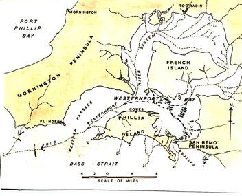
... Sketch map of Westernport Bay region showing probable drainage directions of the ancient river system. Drawn by Dr G Baker from original maps by E S Hills D.Sc....Phillip Island and District Historical Society Inc. phillip-island-and-the-bass-coast One of a collection of over 400 sketches & photographs in an album commenced in 1960 and presented to the Phillip Island & Westernport Historical Society by the Shire of Phillip Island local history illustrations pen & ink westernport bay region black & white sketch physiography Dr G Baker E S Hill D.Sc John Jenner Bryant West Sketch map of Westernport Bay region showing probable drainage directions of the ancient river system. Drawn by Dr G Baker from original maps by E S Hills D.Sc. ...One of a collection of over 400 sketches & photographs in an album commenced in 1960 and presented to the Phillip Island & Westernport Historical Society by the Shire of Phillip IslandSketch map of Westernport Bay region showing probable drainage directions of the ancient river system. Drawn by Dr G Baker from original maps by E S Hills D.Sc.local history, illustrations, pen & ink, westernport bay region, black & white sketch, physiography, dr g baker, e s hill d.sc, john jenner, bryant west -
Tatura Irrigation & Wartime Camps Museum
Program, Goulburn Weir Rehabilitation Works Opening Ceremony
... Includes weir construction history, aboriginal names of Victoria, map, Goulburn River system...Tatura Irrigation & Wartime Camps Museum 49 Hogan Street Tatura the-murray Includes weir construction history, aboriginal names of Victoria, map, Goulburn River system irrigation document program rural industry Program of Opening Ceremony. ...Includes weir construction history, aboriginal names of Victoria, map, Goulburn River systemProgram of Opening Ceremony. White paper, black writing, blue water wheel logo in plastic sleeveirrigation, document, program, rural, industry -
 Lakes Entrance Historical Society
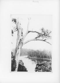
Photograph - Lake Tyers Victoria c1905, Caire, Nicholas John, 1905c
... View of one of the lakes on the Lake Tyers river system showing a calm waterway and timbered banks Small paddle boat 'Sunbeam' used as tourist launch...Lakes Entrance Historical Society 4 Marine Parade Lakes Entrance gippsland View of one of the lakes on the Lake Tyers river system showing a calm waterway and timbered banks Small paddle boat 'Sunbeam' used as tourist launch Waterways Boats and Boating Tourism Black and white photograph of a view of one of the lakes on the Lake Tyers system showing a calm waterway and densely timbered banks. ...View of one of the lakes on the Lake Tyers river system showing a calm waterway and timbered banks Small paddle boat 'Sunbeam' used as tourist launchBlack and white photograph of a view of one of the lakes on the Lake Tyers system showing a calm waterway and densely timbered banks. There is a small steamboat anchored in the lake. Lake Tyers Victoriawaterways, boats and boating, tourism -
Tatura Irrigation & Wartime Camps Museum
Book, The Supply of Water for Irrigation in Victoria 1881-1981, 1981
... Includes history of early irrigation schemes, Goulburn system, river Murray system, Post war expansion, drainage and salinity. ...Tatura Irrigation & Wartime Camps Museum 49 Hogan Street Tatura the-murray Includes history of early irrigation schemes, Goulburn system, river Murray system, Post war expansion, drainage and salinity. ...Includes history of early irrigation schemes, Goulburn system, river Murray system, Post war expansion, drainage and salinity. Change from State Rivers & Water Supply Commission to Rural CommissionCream cover, black writing. Cover photo of early days of irrigation, many channels constructed by teams of horses dragging scoops.sr & wscommision, books, rural, industry -
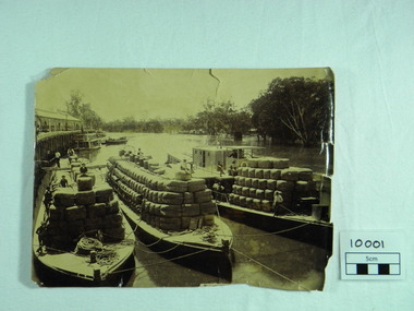 Port of Echuca
Photograph, P.S. Rodney with barges Horace & Nelson, c.1890
... P.S Rodney with barges Horace & Nelson laden with wool bales bought into the Port to be unloaded onto rail trucks to go to markets in Melbourne. c.1890 Paddlesteamers travelled the river systems to bring wool from out- lying properties into the Port of Echuca to be transported by rail to Melbourne. ...Port of Echuca 74 Murray Esplanade Echuca the-murray P.S Rodney with barges Horace & Nelson laden with wool bales bought into the Port to be unloaded onto rail trucks to go to markets in Melbourne. c.1890 Paddlesteamers travelled the river systems to bring wool from out- lying properties into the Port of Echuca to be transported by rail to Melbourne. ...P.S Rodney with barges Horace & Nelson laden with wool bales bought into the Port to be unloaded onto rail trucks to go to markets in Melbourne. c.1890 Paddlesteamers travelled the river systems to bring wool from out- lying properties into the Port of Echuca to be transported by rail to Melbourne. This was prior to road & rail transport in the 1800'sOne of thousands of photos taken depicting the transportation of wool from out- lying properties to the rail head at Port of Echuca using paddlesteamers. P.S.Rodney alongside barges Horace & Nelson, tied to historic Echuca Wharf, with Pride of the Murray paddlesteamer & barge in back ground all vessels loaded with wool bales and crew resting on these. Riverbank lined with red gums. Handwritten in pen on lower left back corner "Rodney with barges Horace & Nelson c. 1890"farming, economy, p s rodney, port of echuca, wool bales, wharf, barges, horrace, nelson, paddlesteamer rodney, echuca -
Tatura Irrigation & Wartime Camps Museum
Book, Irrigation and Water Supply Development in Victoria, 1954
... Reference to Eildon Reservoir, Goulburn Weir, Waranga Reservoir, River Murray irrigation systems...Reference to Eildon Reservoir, Goulburn Weir, Waranga Reservoir, River Murray irrigation systems irrigation water supply goulburn river books history local Buff and blue covered book, showing farmhouse, dairy cattle on front cover, cattle, trees and channel on back Irrigation and Water Supply Development in Victoria Book ...History of irrigaton in Victoria. Reference to Eildon Reservoir, Goulburn Weir, Waranga Reservoir, River Murray irrigation systemsBuff and blue covered book, showing farmhouse, dairy cattle on front cover, cattle, trees and channel on backirrigation, water supply, goulburn river, books, history, local -
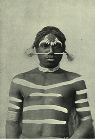 Federation University Historical Collection
Image - black and white, Barwon River Man (New South Wales)
... Digitised directly from 'The Native Races of the British Empire: Victoria' The Barwon River in New South Wales is formed through the confluence of the Macintyre River and Weir River (part of the Border Rivers system), north of Mungindi, in the Southern Downs region of Queensland. ...Barker Library (top floor) Mount Helen goldfields Digitised directly from 'The Native Races of the British Empire: Victoria' The Barwon River in New South Wales is formed through the confluence of the Macintyre River and Weir River (part of the Border Rivers system), north of Mungindi, in the Southern Downs region of Queensland. ...Digitised directly from 'The Native Races of the British Empire: Victoria' The Barwon River in New South Wales is formed through the confluence of the Macintyre River and Weir River (part of the Border Rivers system), north of Mungindi, in the Southern Downs region of Queensland. The Barwon River generally flows south and west, joined by 36 tributaries, including major inflows from the Boomi, Moonie, Gwydir, Mehi, Namoi, Macquarie, Bokhara and Bogan rivers. During major flooding, overflow from the Narran Lakes and the Narran River also flows into the Barwon. The confluence of the Barwon and Culgoa rivers, between Brewarrina and Bourke, marks the start of the Darling River.Black and white Image of an Aboriginal man from Barwon River, New South Wales. Aboriginal people from six language groups originally occupied the area of the Barwon River wetlands. These were the Ngemba, the Baranbinja, the Murrawari, the Ualayai, the Weilwan, and the Kamilaroi peoples. The Aboriginal people generally used the wetlands for hunting, fishing, and gathering uses, and for cultural association.(Wikipedia) The name "barwon" is derived from the Australian Aboriginal words of barwum or bawon, meaning great, wide, awful river of muddy water; and also baawan, a Ngiyambaa name for both the Barwon and Darling rivers. The history, culture and livelihoods of the local Aboriginal people are closely intertwined with the Barwon River and its associated tributaries and downstream flows. (Wikipedia)aborigine, aboriginal, barwon river -
Ringwood and District Historical Society
Envelope, Packet: Ringwood Area Environment - Land Conservation Council, 150 years of Victoria's Rivers 1989. Heritage Inventory
... Historic places, Land Conservation Council relating to past 150 years of Victoria's rivers, streams and water systems; Heritage inventory...Ringwood and District Historical Society 125A Warrandyte Road Ringwood North melbourne Historic places, Land Conservation Council relating to past 150 years of Victoria's rivers, streams and water systems; Heritage inventory Packet: Ringwood Area Environment - Land Conservation Council, 150 years of Victoria's Rivers 1989. ...Historic places, Land Conservation Council relating to past 150 years of Victoria's rivers, streams and water systems; Heritage inventory -
 Sunshine and District Historical Society Incorporated
Poster - Garry The Growling Grass Frog Poster, Trevor Marriott et al, April 2026
... The short‑finned eel (Anguilla australis) is a native, culturally significant, and historically abundant species in the Maribyrnong River system, including the Brimbank stretch. It is one of the two major eel species in Victoria and was a key food source for Wurundjeri Woi‑wurrung people....The short‑finned eel (Anguilla australis) is a native, culturally significant, and historically abundant species in the Maribyrnong River system, including the Brimbank stretch. It is one of the two major eel species in Victoria and was a key food source for Wurundjeri Woi‑wurrung people. ...Trevor Marriott, Creator / Artist created this poster with images and QR codes linked to voice media files. This poster has a unique way of trying an interactive approach of engaging youth with the history of Brimbank by means of QR codes. Garry the Growling Grass Frog refers to the Growling Grass Frog (Litoria raniformis), one of south‑eastern Australia’s most iconic and now vulnerable wetland species. The name “Garry” is often used informally in education programs, frog census activities, and community conservation projects to make the species more relatable, especially for kids and local engagement. The short‑finned eel (Anguilla australis) is a native, culturally significant, and historically abundant species in the Maribyrnong River system, including the Brimbank stretch. It is one of the two major eel species in Victoria and was a key food source for Wurundjeri Woi‑wurrung people.This project, described as "Know Your Place - Animation", was undertaken by Trevor Marriott, with the sponsorship of Brimbank City Council and the generous support of the Sunshine & District Historical Society, who served as the project’s benefactor.Scan QR codes to talk to Garry the Growling Grass frog and other fun Where to get your free freddo Augmented Reality Harvester history See my friend Ellie the Short finned Eel Talk to Sunny about the Fair Go rulesunshine and district historical society, growling grass frog, short fin eel -
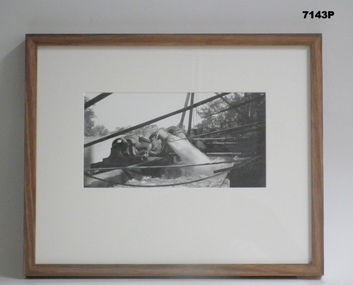 Bendigo Military Museum
Photograph - FRAMED WW1 PHOTOGRAPH, Wayne Eels, C.2008/2009
... Photograph - black and white photograph on paper depicting a pump outlet gushing water into an irrigation system. Background - river and trees. Frame - Timber, light varnish finish, Perspex front, cardboard backing....Photograph - black and white photograph on paper depicting a pump outlet gushing water into an irrigation system. Background - river and trees. Frame - Timber, light varnish finish, Perspex front, cardboard backing. ...The Grinton Collection. Life after 1919, shows an irrigation system. Refer Cat No 1280 for Jack Grintons service details.Photograph - Framed. Photograph - black and white photograph on paper depicting a pump outlet gushing water into an irrigation system. Background - river and trees. Frame - Timber, light varnish finish, Perspex front, cardboard backing."Group 6: Life after 1919". "L. Irrigation system".framed accesssories, camera on the somme, ww1, 38th bn, grinton -
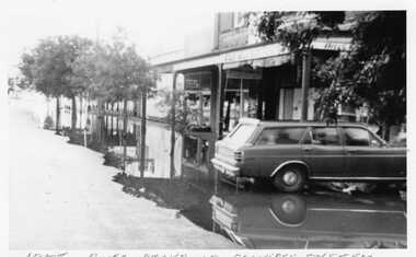 Charlton Golden Grains Museum Inc
Photograph
... Avoca River flooding 1975. River backs up drainage system - 1975. High Street looking from in front of Bill's Cafe towards monument. ...Charlton Golden Grains Museum Inc 1 High Street Charlton goldfields Avoca River flooding 1975. River backs up drainage system - 1975. High Street looking from in front of Bill's Cafe towards monument. ...Avoca River flooding 1975. River backs up drainage system - 1975. High Street looking from in front of Bill's Cafe towards monument. Ford Falcon station wagon in front right of picture.Unmounted black & white photoavoca river, floods -
 Warrnambool and District Historical Society Inc.
Administrative record - Warrnambool Waterworks Newspaper Cuttings, 1891 to 1917
... In 1891 the Warrnambool Waterworks Trust was formed using water from the Merri River. This system lasted until 1939 when the Warrnambool water supply came from the Otway ranges. ...In 1891 the Warrnambool Waterworks Trust was formed using water from the Merri River. This system lasted until 1939 when the Warrnambool water supply came from the Otway ranges. ...This ledger contains newspaper cuttings form The Warrnambool Standard newspaper from May 1891 to October 1917. The cuttings are reports of meetings of the Warrnambool Waterworks Trust. In the early days of Warrnambool domestic water and water for fire suppression was supplied by tanks, wells and springs. In the 1870s various schemes were proposed to find a better supply of water. In 1891 the Warrnambool Waterworks Trust was formed using water from the Merri River. This system lasted until 1939 when the Warrnambool water supply came from the Otway ranges. This system is still the water supply for Warrnambool today. The cuttings in this ledger will be useful for research.This is a ledger with a brown mottled cover and a leather spine and leather corners. The spine is partly detached. The front cover has a label pasted on it. The pages originally had hand written entries (The Minutes of a Warrnambool organisation). Newspaper cuttings have been pasted over the original writing. Warrnambool Waterworks Trust Newspaper Reports From 19th May 1891 To --- warrnambool waterworks trust, warrnambool water supply -
 Bendigo Historical Society Inc.
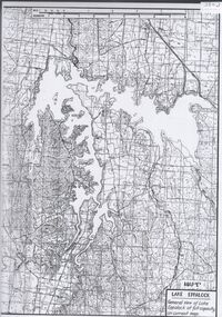
Map - Laminated map of Lake Eppalock at full capacity. Map 'E'
... Built between 1961 and 1964, Lake Eppalock remains the only water storage on the Campaspe River system....Built between 1961 and 1964, Lake Eppalock remains the only water storage on the Campaspe River system. Map Laminated map of Lake Eppalock at full capacity. ...John Perry Collection. Laminated map of Lake Eppalock at full capacity. Black and white. The dam was built by the State Rivers and Water Supply Commission of Victoria. The dam wall height is 45 metres (148 ft) and the main embankment is 1,041 metres (3,415 ft) long. At 100% capacity the dam wall was designed to hold back 304,651 megalitres (6.7014×10¹⁰ imp gal; 8.0480×10¹⁰ US gal) of water. The surface area of Lake Eppalock is 3,011 hectares (7,440 acres) and the catchment area is 2,124 square kilometres (820 sq mi). The controlled spillway is capable of discharging 8,040 cubic metres per second (284,000 cu ft/s). Lake Eppalock supplies both stock and domestic water to the Campaspe irrigation district. It also serves as a water supply to Bendigo and Heathcote and, in more recent times, Ballarat. The lake is a major attraction for those engaging in watersports, with a number of tourist parks and accommodation facilities available. Permissible activities on the lake include high-speed boating, water skiing, sailing, canoeing, fishing and swimming. The lake's water levels were low for approximately eight years between 2002 and 2010 during a prolonged drought, which restricted the amount of recreational activity until rainfall in the latter half of 2010 returned the lake to 100 percent capacity. Built between 1961 and 1964, Lake Eppalock remains the only water storage on the Campaspe River system.map, eppalock, water, dam, reservoir -
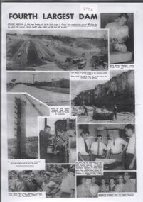 Bendigo Historical Society Inc.
Document - Collection of photographs from newspaper on a single page
... Built between 1961 and 1964, Lake Eppalock remains the only water storage on the Campaspe River system. ...Built between 1961 and 1964, Lake Eppalock remains the only water storage on the Campaspe River system. Document Collection of photographs from newspaper on a single page ...John Perry Collection. Laminated copy of page from 'Weekly Times' newspaper, February, 1962. Nine images relating to establishing and building Eppalock Reservoir, 15 miles from Bendigo. The dam was built by the State Rivers and Water Supply Commission of Victoria. The dam wall height is 45 metres (148 ft) and the main embankment is 1,041 metres (3,415 ft) long. At 100% capacity the dam wall was designed to hold back 304,651 megalitres (6.7014×10¹⁰ imp gal; 8.0480×10¹⁰ US gal) of water. The surface area of Lake Eppalock is 3,011 hectares (7,440 acres) and the catchment area is 2,124 square kilometres (820 sq mi). The controlled spillway is capable of discharging 8,040 cubic metres per second (284,000 cu ft/s). Lake Eppalock supplies both stock and domestic water to the Campaspe irrigation district. It also serves as a water supply to Bendigo and Heathcote and, in more recent times, Ballarat. The lake is a major attraction for those engaging in watersports, with a number of tourist parks and accommodation facilities available. Permissible activities on the lake include high-speed boating, water skiing, sailing, canoeing, fishing and swimming. The lake's water levels were low for approximately eight years between 2002 and 2010 during a prolonged drought, which restricted the amount of recreational activity until rainfall in the latter half of 2010 returned the lake to 100 percent capacity. Built between 1961 and 1964, Lake Eppalock remains the only water storage on the Campaspe River system. dam, engineering, water, eppalock -
 Bendigo Historical Society Inc.
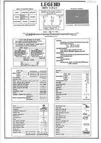
Document - Legend to maps A, B and C for Lake Eppalock
... Built between 1961 and 1964, Lake Eppalock remains the only water storage on the Campaspe River system....Built between 1961 and 1964, Lake Eppalock remains the only water storage on the Campaspe River system. Document Legend to maps A, B and C for Lake Eppalock. ...John Perry Collection. Laminated 'legend' for Maps A, B and C for Lake Eppalock also in this collection. Black and White definitions and descriptions of objects and markers found on maps. Circa 1951. The dam was built by the State Rivers and Water Supply Commission of Victoria. The dam wall height is 45 metres (148 ft) and the main embankment is 1,041 metres (3,415 ft) long. At 100% capacity the dam wall was designed to hold back 304,651 megalitres (6.7014×10¹⁰ imp gal; 8.0480×10¹⁰ US gal) of water. The surface area of Lake Eppalock is 3,011 hectares (7,440 acres) and the catchment area is 2,124 square kilometres (820 sq mi). The controlled spillway is capable of discharging 8,040 cubic metres per second (284,000 cu ft/s). Lake Eppalock supplies both stock and domestic water to the Campaspe irrigation district. It also serves as a water supply to Bendigo and Heathcote and, in more recent times, Ballarat. The lake is a major attraction for those engaging in watersports, with a number of tourist parks and accommodation facilities available. Permissible activities on the lake include high-speed boating, water skiing, sailing, canoeing, fishing and swimming. The lake's water levels were low for approximately eight years between 2002 and 2010 during a prolonged drought, which restricted the amount of recreational activity until rainfall in the latter half of 2010 returned the lake to 100 percent capacity. Built between 1961 and 1964, Lake Eppalock remains the only water storage on the Campaspe River system.map, water, dam, reservoir, eppalock -
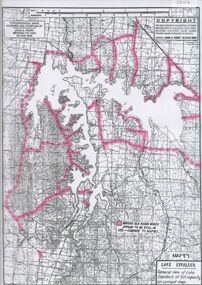
 Bendigo Historical Society Inc.
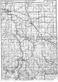
Map - General view of area of proposed construction of Lake Eppalock. Map 'A'
... Built between 1961 and 1964, Lake Eppalock remains the only water storage on the Campaspe River system....Built between 1961 and 1964, Lake Eppalock remains the only water storage on the Campaspe River system. Map General view of area of proposed construction of Lake Eppalock. ...John Perry Collection. Laminated map of proposed construction of Lake Eppalock. Map 'A'. Black and white map in laminate. Circa 1951. The dam was built by the State Rivers and Water Supply Commission of Victoria. The dam wall height is 45 metres (148 ft) and the main embankment is 1,041 metres (3,415 ft) long. At 100% capacity the dam wall was designed to hold back 304,651 megalitres (6.7014×10¹⁰ imp gal; 8.0480×10¹⁰ US gal) of water. The surface area of Lake Eppalock is 3,011 hectares (7,440 acres) and the catchment area is 2,124 square kilometres (820 sq mi). The controlled spillway is capable of discharging 8,040 cubic metres per second (284,000 cu ft/s). Lake Eppalock supplies both stock and domestic water to the Campaspe irrigation district. It also serves as a water supply to Bendigo and Heathcote and, in more recent times, Ballarat. The lake is a major attraction for those engaging in watersports, with a number of tourist parks and accommodation facilities available. Permissible activities on the lake include high-speed boating, water skiing, sailing, canoeing, fishing and swimming. The lake's water levels were low for approximately eight years between 2002 and 2010 during a prolonged drought, which restricted the amount of recreational activity until rainfall in the latter half of 2010 returned the lake to 100 percent capacity. Built between 1961 and 1964, Lake Eppalock remains the only water storage on the Campaspe River system.map, dam, water, weir, eppalock -
 Bendigo Historical Society Inc.
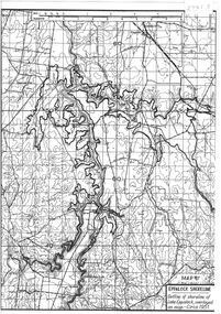
Map - Black and White map. Outline of Lake Eppalock. Map 'B'
... Built between 1961 and 1964, Lake Eppalock remains the only water storage on the Campaspe River system....Built between 1961 and 1964, Lake Eppalock remains the only water storage on the Campaspe River system. Map Black and White map. Outline of Lake Eppalock. ...John Perry Collection. Laminated copy black and white map. Map 'B'. Outline of Lake Eppalcok, overlayed on map. Circa 1951. The dam was built by the State Rivers and Water Supply Commission of Victoria. The dam wall height is 45 metres (148 ft) and the main embankment is 1,041 metres (3,415 ft) long. At 100% capacity the dam wall was designed to hold back 304,651 megalitres (6.7014×10¹⁰ imp gal; 8.0480×10¹⁰ US gal) of water. The surface area of Lake Eppalock is 3,011 hectares (7,440 acres) and the catchment area is 2,124 square kilometres (820 sq mi). The controlled spillway is capable of discharging 8,040 cubic metres per second (284,000 cu ft/s). Lake Eppalock supplies both stock and domestic water to the Campaspe irrigation district. It also serves as a water supply to Bendigo and Heathcote and, in more recent times, Ballarat. The lake is a major attraction for those engaging in watersports, with a number of tourist parks and accommodation facilities available. Permissible activities on the lake include high-speed boating, water skiing, sailing, canoeing, fishing and swimming. The lake's water levels were low for approximately eight years between 2002 and 2010 during a prolonged drought, which restricted the amount of recreational activity until rainfall in the latter half of 2010 returned the lake to 100 percent capacity. Built between 1961 and 1964, Lake Eppalock remains the only water storage on the Campaspe River system.map, water, dam, reservoir, eppalock -
 Bendigo Historical Society Inc.
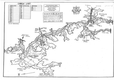
Map - Black and white map pertaining to Lake Eppalock
... Built between 1961 and 1964, Lake Eppalock remains the only water storage on the Campaspe River system....Built between 1961 and 1964, Lake Eppalock remains the only water storage on the Campaspe River system. Map Black and white map pertaining to Lake Eppalock ...John Perry Collection. Laminated copy of map relating to Lake Eppalock. Lists dwellings, ford crossings and bridges. The dam was built by the State Rivers and Water Supply Commission of Victoria. The dam wall height is 45 metres (148 ft) and the main embankment is 1,041 metres (3,415 ft) long. At 100% capacity the dam wall was designed to hold back 304,651 megalitres (6.7014×10¹⁰ imp gal; 8.0480×10¹⁰ US gal) of water. The surface area of Lake Eppalock is 3,011 hectares (7,440 acres) and the catchment area is 2,124 square kilometres (820 sq mi). The controlled spillway is capable of discharging 8,040 cubic metres per second (284,000 cu ft/s). Lake Eppalock supplies both stock and domestic water to the Campaspe irrigation district. It also serves as a water supply to Bendigo and Heathcote and, in more recent times, Ballarat. The lake is a major attraction for those engaging in watersports, with a number of tourist parks and accommodation facilities available. Permissible activities on the lake include high-speed boating, water skiing, sailing, canoeing, fishing and swimming. The lake's water levels were low for approximately eight years between 2002 and 2010 during a prolonged drought, which restricted the amount of recreational activity until rainfall in the latter half of 2010 returned the lake to 100 percent capacity. Built between 1961 and 1964, Lake Eppalock remains the only water storage on the Campaspe River system.map, water, dam, reservoir, eppalock -
 Bendigo Historical Society Inc.
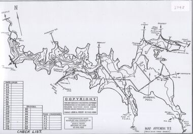
Map - Black and white map pertaining to Lake Eppalock
... Built between 1961 and 1964, Lake Eppalock remains the only water storage on the Campaspe River system....Built between 1961 and 1964, Lake Eppalock remains the only water storage on the Campaspe River system. Map Black and white map pertaining to Lake Eppalock ...John Perry Collection. Laminated copy of map pertaining to Lake Eppalock. Gives details of dwellings, bridges and ford crossings. The dam was built by the State Rivers and Water Supply Commission of Victoria. The dam wall height is 45 metres (148 ft) and the main embankment is 1,041 metres (3,415 ft) long. At 100% capacity the dam wall was designed to hold back 304,651 megalitres (6.7014×10¹⁰ imp gal; 8.0480×10¹⁰ US gal) of water. The surface area of Lake Eppalock is 3,011 hectares (7,440 acres) and the catchment area is 2,124 square kilometres (820 sq mi). The controlled spillway is capable of discharging 8,040 cubic metres per second (284,000 cu ft/s). Lake Eppalock supplies both stock and domestic water to the Campaspe irrigation district. It also serves as a water supply to Bendigo and Heathcote and, in more recent times, Ballarat. The lake is a major attraction for those engaging in watersports, with a number of tourist parks and accommodation facilities available. Permissible activities on the lake include high-speed boating, water skiing, sailing, canoeing, fishing and swimming. The lake's water levels were low for approximately eight years between 2002 and 2010 during a prolonged drought, which restricted the amount of recreational activity until rainfall in the latter half of 2010 returned the lake to 100 percent capacity. Built between 1961 and 1964, Lake Eppalock remains the only water storage on the Campaspe River system.eppalock, map, water, dam, reservoir -
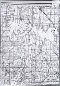 Bendigo Historical Society Inc.
Map - Map of overlay of lake Eppalock at full capacity. Map 'C'
... Built between 1961 and 1964, Lake Eppalock remains the only water storage on the Campaspe River system....Built between 1961 and 1964, Lake Eppalock remains the only water storage on the Campaspe River system. Map Map of overlay of lake Eppalock at full capacity. ...John Perry collection. Map 'C'. Laminated map of overlay of Lake Eppalock at full capacity. Circa 1951. The dam was built by the State Rivers and Water Supply Commission of Victoria. The dam wall height is 45 metres (148 ft) and the main embankment is 1,041 metres (3,415 ft) long. At 100% capacity the dam wall was designed to hold back 304,651 megalitres (6.7014×10¹⁰ imp gal; 8.0480×10¹⁰ US gal) of water. The surface area of Lake Eppalock is 3,011 hectares (7,440 acres) and the catchment area is 2,124 square kilometres (820 sq mi). The controlled spillway is capable of discharging 8,040 cubic metres per second (284,000 cu ft/s). Lake Eppalock supplies both stock and domestic water to the Campaspe irrigation district. It also serves as a water supply to Bendigo and Heathcote and, in more recent times, Ballarat. The lake is a major attraction for those engaging in watersports, with a number of tourist parks and accommodation facilities available. Permissible activities on the lake include high-speed boating, water skiing, sailing, canoeing, fishing and swimming. The lake's water levels were low for approximately eight years between 2002 and 2010 during a prolonged drought, which restricted the amount of recreational activity until rainfall in the latter half of 2010 returned the lake to 100 percent capacity. Built between 1961 and 1964, Lake Eppalock remains the only water storage on the Campaspe River system.map, water, eppalock, dam, reservoir -
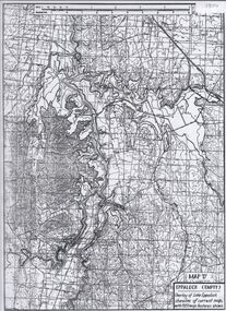 Bendigo Historical Society Inc.
Map - Laminated map of Lake Eppalock empty. Map 'D'
... Built between 1961 and 1964, Lake Eppalock remains the only water storage on the Campaspe River system....Built between 1961 and 1964, Lake Eppalock remains the only water storage on the Campaspe River system. Map Laminated map of Lake Eppalock empty. ...John Perry Collection. Laminated map of Lake Eppalock empty. Map 'D'. Circa 1951. The dam was built by the State Rivers and Water Supply Commission of Victoria. The dam wall height is 45 metres (148 ft) and the main embankment is 1,041 metres (3,415 ft) long. At 100% capacity the dam wall was designed to hold back 304,651 megalitres (6.7014×10¹⁰ imp gal; 8.0480×10¹⁰ US gal) of water. The surface area of Lake Eppalock is 3,011 hectares (7,440 acres) and the catchment area is 2,124 square kilometres (820 sq mi). The controlled spillway is capable of discharging 8,040 cubic metres per second (284,000 cu ft/s). Lake Eppalock supplies both stock and domestic water to the Campaspe irrigation district. It also serves as a water supply to Bendigo and Heathcote and, in more recent times, Ballarat. The lake is a major attraction for those engaging in watersports, with a number of tourist parks and accommodation facilities available. Permissible activities on the lake include high-speed boating, water skiing, sailing, canoeing, fishing and swimming. The lake's water levels were low for approximately eight years between 2002 and 2010 during a prolonged drought, which restricted the amount of recreational activity until rainfall in the latter half of 2010 returned the lake to 100 percent capacity. Built between 1961 and 1964, Lake Eppalock remains the only water storage on the Campaspe River system.map, water, dam, reservoir, eppalock -
 Bendigo Historical Society Inc.
Map - Laminated map of Lake Eppalock at full capacity
... Built between 1961 and 1964, Lake Eppalock remains the only water storage on the Campaspe River system....Built between 1961 and 1964, Lake Eppalock remains the only water storage on the Campaspe River system. Map Laminated map of Lake Eppalock at full capacity. ...John Perry Collection. Laminated copy of map of Lake Eppalock at full capacity. Had highlighter markings of old roads which appear to be still in use. The dam was built by the State Rivers and Water Supply Commission of Victoria. The dam wall height is 45 metres (148 ft) and the main embankment is 1,041 metres (3,415 ft) long. At 100% capacity the dam wall was designed to hold back 304,651 megalitres (6.7014×10¹⁰ imp gal; 8.0480×10¹⁰ US gal) of water. The surface area of Lake Eppalock is 3,011 hectares (7,440 acres) and the catchment area is 2,124 square kilometres (820 sq mi). The controlled spillway is capable of discharging 8,040 cubic metres per second (284,000 cu ft/s). Lake Eppalock supplies both stock and domestic water to the Campaspe irrigation district. It also serves as a water supply to Bendigo and Heathcote and, in more recent times, Ballarat. The lake is a major attraction for those engaging in watersports, with a number of tourist parks and accommodation facilities available. Permissible activities on the lake include high-speed boating, water skiing, sailing, canoeing, fishing and swimming. The lake's water levels were low for approximately eight years between 2002 and 2010 during a prolonged drought, which restricted the amount of recreational activity until rainfall in the latter half of 2010 returned the lake to 100 percent capacity. Built between 1961 and 1964, Lake Eppalock remains the only water storage on the Campaspe River system.map, water, dam, reservoir, eppalock -
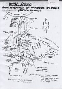 Bendigo Historical Society Inc.
Map - Laminated worksheet - identification of inundated artifacts at Lake Eppalock
... Built between 1961 and 1964, Lake Eppalock remains the only water storage on the Campaspe River system....Built between 1961 and 1964, Lake Eppalock remains the only water storage on the Campaspe River system. Map Laminated worksheet - identification of inundated artifacts at Lake Eppalock. ...John Perry Collection. Laminated copy of worksheet identifying inundated artifacts at Lake Eppalock when at 10% capacity. The dam was built by the State Rivers and Water Supply Commission of Victoria. The dam wall height is 45 metres (148 ft) and the main embankment is 1,041 metres (3,415 ft) long. At 100% capacity the dam wall was designed to hold back 304,651 megalitres (6.7014×10¹⁰ imp gal; 8.0480×10¹⁰ US gal) of water. The surface area of Lake Eppalock is 3,011 hectares (7,440 acres) and the catchment area is 2,124 square kilometres (820 sq mi). The controlled spillway is capable of discharging 8,040 cubic metres per second (284,000 cu ft/s). Lake Eppalock supplies both stock and domestic water to the Campaspe irrigation district. It also serves as a water supply to Bendigo and Heathcote and, in more recent times, Ballarat. The lake is a major attraction for those engaging in watersports, with a number of tourist parks and accommodation facilities available. Permissible activities on the lake include high-speed boating, water skiing, sailing, canoeing, fishing and swimming. The lake's water levels were low for approximately eight years between 2002 and 2010 during a prolonged drought, which restricted the amount of recreational activity until rainfall in the latter half of 2010 returned the lake to 100 percent capacity. Built between 1961 and 1964, Lake Eppalock remains the only water storage on the Campaspe River system.map, artifacts, eppalock, reservoir