Showing 11 items matching "riversdale avenue"
-
 Eltham District Historical Society Inc
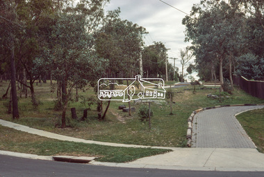
Photograph, Riversdale Avenue, Eltham North, Oct. 1980
... Riversdale Avenue, Eltham North......riversdale avenue...Infrastructure benchmark studies infrastructure roads eltham north dale avenue riversdale avenue 35mm colour positive transparency (1 of 24) Mount - Kodak Kodachrome Card Riversdale Avenue, Eltham North Photograph Photograph ...Diamond Valley Shire new street scheme. Infrastructure benchmark studies35mm colour positive transparency (1 of 24) Mount - Kodak Kodachrome Cardinfrastructure, roads, eltham north, dale avenue, riversdale avenue -
 Eltham District Historical Society Inc
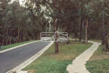
Photograph, Riversdale Avenue, Eltham North, Oct. 1980
... Riversdale Avenue, Eltham North......Riversdale Avenue...Infrastructure benchmark studies infrastructure roads eltham north Gracedale Avenue Riversdale Avenue 35mm colour positive transparency (1 of 24) Mount - Kodak Kodachrome Card Colour print enlargement 27 x 35.5 cm Riversdale Avenue, Eltham North Photograph Photograph ...Diamond Valley Shire new street scheme. Infrastructure benchmark studies35mm colour positive transparency (1 of 24) Mount - Kodak Kodachrome Card Colour print enlargement 27 x 35.5 cminfrastructure, roads, eltham north, gracedale avenue, riversdale avenue -
 Eltham District Historical Society Inc
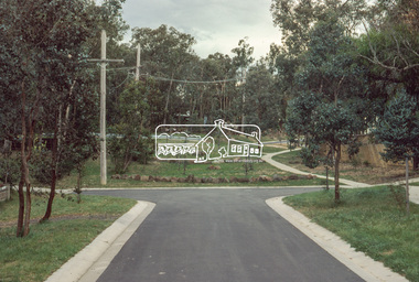
Photograph, Riversdale Avenue, Eltham North, Oct. 1980
... Riversdale Avenue, Eltham North......riversdale avenue...Infrastructure benchmark studies infrastructure roads eltham north gracedale avenue riversdale avenue 35mm colour positive transparency (1 of 24) Mount - Kodak Kodachrome Card Riversdale Avenue, Eltham North Photograph Photograph ...Diamond Valley Shire new street scheme. Infrastructure benchmark studies35mm colour positive transparency (1 of 24) Mount - Kodak Kodachrome Cardinfrastructure, roads, eltham north, gracedale avenue, riversdale avenue -
 Eltham District Historical Society Inc
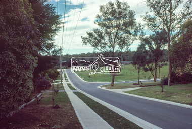
Photograph, Brixton Avenue, Eltham North, Oct. 1980
... ...Riversdale Avenue...Eltham District Historical Society Inc 728 Main Rd Eltham melbourne Diamond Valley Shire new street scheme infrastructure roads Brixton Avenue Eltham North Glendale reserve Riversdale Avenue 35mm colour positive transparency (1 of 24) Mount - Kodak Kodachrome Card Brixton Avenue, Eltham North Photograph Photograph ...Diamond Valley Shire new street scheme35mm colour positive transparency (1 of 24) Mount - Kodak Kodachrome Cardinfrastructure, roads, brixton avenue, eltham north, glendale reserve, riversdale avenue -
 Camberwell Historical Society
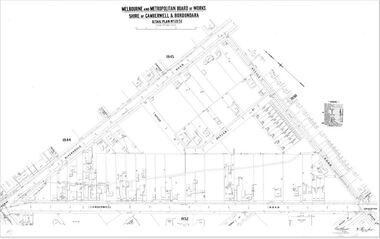
Map (Item) - MMBW map, Melbourne and Metropolitan Board of Works, Melbourne and Metropolitan Board of Works - Shire of Boroondara and Camberwell - Detail Plan no. 1851, July 1904
... MMBW Detail Plan showing Camberwell Junction, Camberwell Road, Riversdale Road and Avenue Road - dated July 1904...MMBW Detail Plan showing Camberwell Junction, Camberwell Road, Riversdale Road and Avenue Road - dated July 1904 Melbourne and Metropolitan Board of Works - Shire of Boroondara and Camberwell - Detail Plan no. 1851 Map MMBW map Melbourne and Metropolitan Board of Works ...Lithographer JEM, exd. JWD, July 1904, no. 81, 40P. 15W.melbourne and metropolitan board of works, map, camberwell, cartography -
 Robin Boyd Foundation
Letter, Melbourne and Metropolitan Board of Works, 31.03.1958
... Letter to Robin Boyd regarding his letter about the proposed Eastern Suburbs Freeway to cross Riversdale Rd and Woodlands Avenue (right beside 158 Riversdale Rd, the Boyd family home)....Robin Boyd Foundation 290 Walsh Street South Yarra melbourne Letter to Robin Boyd regarding his letter about the proposed Eastern Suburbs Freeway to cross Riversdale Rd and Woodlands Avenue (right beside 158 Riversdale Rd, the Boyd family home). ...Letter to Robin Boyd regarding his letter about the proposed Eastern Suburbs Freeway to cross Riversdale Rd and Woodlands Avenue (right beside 158 Riversdale Rd, the Boyd family home). -
Surrey Hills Historical Society Collection
Folder of real estate advertisements, Folders of real estate advertisements (Streets beginning with Q-R), Various
... riversdale road...robinson road...rose avenue...Surrey Hills Historical Society Collection 190A Canterbury Road Canterbury melbourne queen street redvers street riversdale road robinson road rose avenue ross street rostrevor parade rowland street royal lane russell street A4 folders with individual pockets for each property in streets beginning with Q-R located in Surrey Hills and Mont Albert. ...A4 folders with individual pockets for each property in streets beginning with Q-R located in Surrey Hills and Mont Albert. Folders are ordered by street name and then chronologically by property number. Each property has its own pocket. This may include multiple real estate advertisements collected from sales over time. It may also include copies of any research undertaken by Alan Holt and / or members of the SHNCHC team. These are augmented by cards in the Alan Holt index file and by his property registers of Surrey Hills and Mont Albert.queen street, redvers street, riversdale road, robinson road, rose avenue, ross street, rostrevor parade, rowland street, royal lane, russell street -
Surrey Hills Historical Society Collection
Document - Plans, Andrew Wood, Building plans associated with Andrew Wood, builder of Surrey Hills, 1920s
... .1: Specifications & plans for the kinder hall, Howard Street, Mont Albert for the Mont Albert Methodist Church, May 1925 .2 Plans for a proposed villa, 48 Payne's Paddock, Highfield Road, Canterbury for Mr E H Sillifant, dated 22/4/1920 .3 Plans for a timber villa for Mrs J A Burchell at Riversdale Road, Surrey Hills, stamped 9/5/1922 .4 Plan of a garage at Victoria avenue, Canterbury; stamped 14/2/1922 .5 Building permit & receipt from City of Hawthorn re Lot 16 Homebush Crescent; dated 7/4/1925 .6 Plans for a concrete house at Camberwell for Mr H W Field ...Andrew Wood builders Box Hill Cemetery kindergartens Mont Albert Methodist Church building plans Highfield Road Ernest Horatio Sillifant Victoria Avenue Canterbury Lot 16 Homebush Crescent Californian bungalows H W Field .1: Specifications & plans for the kinder hall, Howard Street, Mont Albert for the Mont Albert Methodist Church, May 1925 .2 Plans for a proposed villa, 48 Payne's Paddock, Highfield Road, Canterbury for Mr E H Sillifant, dated 22/4/1920 .3 Plans for a timber villa for Mrs J A Burchell at Riversdale Road, Surrey Hills, stamped 9/5/1922 .4 Plan of a garage at Victoria avenue, Canterbury; stamped 14/2/1922 .5 Building permit & receipt from City of Hawthorn re Lot 16 Homebush Crescent; dated 7/4/1925 .6 Plans for a concrete house at Camberwell for Mr H W Field Building plans associated with Andrew Wood, builder of Surrey Hills Document Plans Andrew Wood Robin Kelly Peter Bray ...These plans were associated with Mr Andrew Wood, a contract builder who worked in the 1920s and built many Californian bungalows in Surrey Hills and surrounding suburbs. Andrew Wood was born in Chiltern in 1861 to Andrew and Ellen Wood (MS: Green). His father had emigrated from Falkirk, Scotland. As a young man Andrew worked as a carpenter in the mines in South Africa (c 1899). He married Eleanor Agnes Stuchbery in Hamilton, Victoria in May 1901. They had 5 children - Doris (M Roberts), Robert Andrew, Donald Allen, Jean (M Cowan), and Gwenyth (M Bray). The first 2 children were born in Hawthorn; the other 3 in Surrey Hills. The family home at 286 Canterbury Road, Surrey Hills (on the corner of Middlesex Road) was built by Andrew. Andrew died in 1940; Eleanor died in 1977, aged 100 years. After Eleanor's death the house was sold and demolished. Surrey Lighting was established on the site. Gwenyth May Wood (3 May 1917, Surrey Hills - 5 Jan 2004) married Leslie David Charles Bray (1921-1983). Gwenyth was the donor's mother. Andrew, Eleanor and one son Robert are buried in Box Hill Cemetery - B-071-0028. .1: Specifications & plans for the kinder hall, Howard Street, Mont Albert for the Mont Albert Methodist Church, May 1925 .2 Plans for a proposed villa, 48 Payne's Paddock, Highfield Road, Canterbury for Mr E H Sillifant, dated 22/4/1920 .3 Plans for a timber villa for Mrs J A Burchell at Riversdale Road, Surrey Hills, stamped 9/5/1922 .4 Plan of a garage at Victoria avenue, Canterbury; stamped 14/2/1922 .5 Building permit & receipt from City of Hawthorn re Lot 16 Homebush Crescent; dated 7/4/1925 .6 Plans for a concrete house at Camberwell for Mr H W Field andrew wood, builders, box hill cemetery, kindergartens, mont albert methodist church, building plans, highfield road, ernest horatio sillifant, victoria avenue canterbury, lot 16 homebush crescent, californian bungalows, h w field -
Surrey Hills Historical Society Collection
Work on paper - Vertical file on Back Creek, Surrey Hills
... South Surrey Park runs along both sides of Back Creek from where the creek crosses Union Rd near Rose Avenue to where it crosses Riversdale Road just west of Through Road. ...South Surrey Park runs along both sides of Back Creek from where the creek crosses Union Rd near Rose Avenue to where it crosses Riversdale Road just west of Through Road. ...Back Creek is one of the tributaries of Gardiners Creek. It rises as a spring on the slopes of the hill at the corner of Canterbury Road and Elgar Road in Surrey Hills, the location of a Melbourne Water tower and reservoir. It has been channelled underground from this point in pipes as far as Union Road. South Surrey Park runs along both sides of Back Creek from where the creek crosses Union Rd near Rose Avenue to where it crosses Riversdale Road just west of Through Road. A vertical file containing information about Back Creek in Surrey Hills: 1. 4 colour photos taken in 1983 (1 page). 2. ‘Pipe dreams run their course’, (Boroondara Review ?) 17.4.2013 (1 page). 3. ‘Plan rainchecked for creek impact’, Boroondara Review, 13.3.2013 (2 pages). back creek -
Canterbury History Group
Letter - To the editor of The Age, Demaine, Mildred, 1/03/1931 12:00:00 AM
... Riversdale Road... St Barnabas Anglican Church... Shrublands... Carriages and Coaches... Wentworth Avenue...Canterbury Canterbury Road Hawthorn Surrey Hills Riversdale Road St Barnabas Anglican Church Shrublands Carriages and Coaches Wentworth Avenue Outer Circle Railway Demaine Family Kugelmann Store 6 A4 pages. ...Letter to The Age by Mrs Mildred Demaine describing life in early Canterbury . 6 A4 pages. Photocopy of the handwritten letter with a typed copycanterbury, canterbury road, hawthorn, surrey hills, riversdale road, st barnabas anglican church, shrublands, carriages and coaches, wentworth avenue, outer circle railway, demaine family, kugelmann store -
 Melbourne Tram Museum
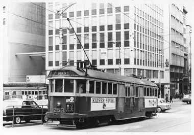
Photograph - Black and White photograph, Ellen Butland, Set of 53 photos, 1974 and 1998
... c1974 Ellen Butland.jpg EB10 W2 606 in St Kilda Road, Route 67. c1973 Ellen Butland.jpg EB11 W2 434 on a tour at South Melbourne Depot, c1974 Ellen Butand.jpg EB12 W2 433 in Riversdale Road, Route 74 service. c1969 Ellen Butand.jpg EB13 W2 418 in St Kida Road, c1974 Ellen Butland.jpg EB14 W2's 432 & 273 in Camberwell Depot, c1968 Ellen Butland.jpg EB15 W2 410, Cotham Road Kew c1968 Ellen Butland.jpg EB16 W2 415 in Riversdale Road, Route 74 service. c1969 Ellen Butland.jpg EB17 W2 418 in St Kilda Road, Route 4D service. c1968 Ellen Butand.jpg EB18 W6 992 in Camberwell Depot, with W2's on other roads c1975 Ellen Butand.jpg EB19 W6 983 in Bourke St, Route 96 service between Russell and Exhibition Streets. Hoys cinema Centre behind. Advertisement for Lloyd Triestino Line. late 1968 Ellen Butland.jpg EB20 W6 968 in Bourke St, Route 89 service. late 1968 Ellen Butand.jpg EB21 9B Truck under a W3 Class car, c1969 Ellen Butland.jpg EB22 Y1 611 at Batman Avenue...Trans Australia Airlines (TAA) Building in Franklin St. in the background. c1970 Ellen Butland.jpg EB5 W2's 470, 397, 273, 526, W5 811 Camberwell Depot, c1970 Ellen Butland.jpg EB6 W2 388 & SW6 852 in Riversdale Road, c1967 Ellen Butland.jpg EB7 W2 410 in Flinders St, Route 48 service. c1970 Ellen Butland.jpg EB8 W2 349 in Royal Park, c1973 Ellen Butland.jpg EB9 W2 385 and AEC MK.VI bus 720 in South Melbourne Depot, This Doncaster Depot bus is on a meal break from working East Malvern tram replacement. c1974 Ellen Butland.jpg EB10 W2 606 in St Kilda Road, Route 67. c1973 Ellen Butland.jpg EB11 W2 434 on a tour at South Melbourne Depot, c1974 Ellen Butand.jpg EB12 W2 433 in Riversdale Road, Route 74 service. c1969 Ellen Butand.jpg EB13 W2 418 in St Kida Road, c1974 Ellen Butland.jpg EB14 W2's 432 & 273 in Camberwell Depot, c1968 Ellen Butland.jpg EB15 W2 410, Cotham Road Kew c1968 Ellen Butland.jpg EB16 W2 415 in Riversdale Road, Route 74 service. c1969 Ellen Butland.jpg EB17 W2 418 in St Kilda Road, Route 4D service. c1968 Ellen Butand.jpg EB18 W6 992 in Camberwell Depot, with W2's on other roads c1975 Ellen Butand.jpg EB19 W6 983 in Bourke St, Route 96 service between Russell and Exhibition Streets. Hoys cinema Centre behind. Advertisement for Lloyd Triestino Line. late 1968 Ellen Butland.jpg EB20 W6 968 in Bourke St, Route 89 service. late 1968 Ellen Butand.jpg EB21 9B Truck under a W3 Class car, c1969 Ellen Butland.jpg EB22 Y1 611 at Batman Avenue ...Set of 53 black and white photographs collected or taken by Ellen Butland - 1964 to 1975 For a listing of the prints see htd5720list.pdf. Word file and scanning by Gary Davey 5/2021 EB1 W2 253 in Collins St, Route 11 service, W2 314 visible in Swanston St. bound for East Coburg. circa 1970 Ellen Butland.jpg EB2 W2 349 on a tour in Dandenong Road, circa 1975 Ellen Butland.jpg EB3 W2 249 in William St, Note the center poles, Route 56 service, Demolition of the Menzies Hotel in progress, c1970 Ellen Butland.jpg EB4 W2 399 in Elizabeth St, Route 59 service. Trans Australia Airlines (TAA) Building in Franklin St. in the background. c1970 Ellen Butland.jpg EB5 W2's 470, 397, 273, 526, W5 811 Camberwell Depot, c1970 Ellen Butland.jpg EB6 W2 388 & SW6 852 in Riversdale Road, c1967 Ellen Butland.jpg EB7 W2 410 in Flinders St, Route 48 service. c1970 Ellen Butland.jpg EB8 W2 349 in Royal Park, c1973 Ellen Butland.jpg EB9 W2 385 and AEC MK.VI bus 720 in South Melbourne Depot, This Doncaster Depot bus is on a meal break from working East Malvern tram replacement. c1974 Ellen Butland.jpg EB10 W2 606 in St Kilda Road, Route 67. c1973 Ellen Butland.jpg EB11 W2 434 on a tour at South Melbourne Depot, c1974 Ellen Butand.jpg EB12 W2 433 in Riversdale Road, Route 74 service. c1969 Ellen Butand.jpg EB13 W2 418 in St Kida Road, c1974 Ellen Butland.jpg EB14 W2's 432 & 273 in Camberwell Depot, c1968 Ellen Butland.jpg EB15 W2 410, Cotham Road Kew c1968 Ellen Butland.jpg EB16 W2 415 in Riversdale Road, Route 74 service. c1969 Ellen Butland.jpg EB17 W2 418 in St Kilda Road, Route 4D service. c1968 Ellen Butand.jpg EB18 W6 992 in Camberwell Depot, with W2's on other roads c1975 Ellen Butand.jpg EB19 W6 983 in Bourke St, Route 96 service between Russell and Exhibition Streets. Hoys cinema Centre behind. Advertisement for Lloyd Triestino Line. late 1968 Ellen Butland.jpg EB20 W6 968 in Bourke St, Route 89 service. late 1968 Ellen Butand.jpg EB21 9B Truck under a W3 Class car, c1969 Ellen Butland.jpg EB22 Y1 611 at Batman Avenue, c1964 Ellen Butland.jpg EB23 W2 588 at South Melbourne Siding, Albert Road. c1968 Ellen Butland.jpg EB24 W2 578 in Riversdale Road, at Glenferrie Road. Route 74 service. c1968 Ellen Butand.jpg EB25 W2 507 on route 7 service and SW6 851 at Camberwell Terminus Burke Road Deepdene, c1967 Ellen Butland.jpg EB26 W4 674 in Swanston St, Route 2A service. c1964 Ellen Butland.jpg EB27 W5 681 on Route 56 entering William St from Peel St. c1969 Ellen Butland.jpg EB28 W5 682 leaving River Street reserve track and swinging into Gordon St. Maribyrnong. Route 82 service. c1971 Ellen Buckland.jpg EB29 W5 772 in Elizabeth St. at Bourke St. Route 19 service. c1968 Ellen Butland.jpg EB30 W5 776 on Route 69 in Glenferrie Road at Henrietta St, Hawthorn. c1968 Ellen Buckland.jpg EB31 W5 786 in Leeds St Footscray Terminus, Route 82. c1972 Ellen Butland.jpg EB32 W3 667 in Swanston St, c1958 or earlier outside the State Library. Ellen Butland.jpg EB33 W2 267 in St Kilda Rd, on Route 8 service, c1935. Copy of a Murray View No.72 Postcard. Ellen Butland.jpg EB34 SW6 900 Advertising Car and a L class car at South Melbourne Depot, Jan 1975 Ellen Butland.jpg EB35 W7 1003 in Spring St, on Route 95 service. c1965 Ellen Butland.jpg EB36 SW6 958 Glen Huntley Road on Route 4, c1953 Ellen Butland.jpg EB37 Z Class 1 and 7 in Victoria Parade, 1975 Ellen Butland.jpg EB38 Z Class 3, 2 & 5 at Preston Workshops, 30-4-1975 Ellen Butland.jpg EB39 Z class 3 in Nicholson St, at Victoria Parade 30-4-1975 Ellen Butland.jpg EB40 Z class no 3 in Queens Parade, 30-4-1975 Ellen Butland.jpg EB41 X 217 in Coldblo Road Malvern Depot, 13-1-1974 Ellen Butland.jpg EB42 W2 220 in Collins St, Route 9 service. c1970 Ellen Butland.jpg EB43 W2 225 in Swanston St, Route 6 service. c1967 Ellen Butland.jpg EB44 W2 233 Road Line Marker Car in South Melbourne Per way yard, c1976 Ellen Butland.jpg EB45 W2 242 in Brunswick Depot, c1968 Ellen Butland.jpg EB46 W7 1007 in Collins St, at Market St. Route 9A service. c1970 Ellen Butland.jpg EB47 W7 1013 in Bourke St, The Southern Cross Hotel behind. Route 88 service. c1970 Ellen Butland.jpg EB48 W7 1020 in LaTrobe St, at Elizabeth St. Route 9E service. c1969 Ellen Butland.jpg EB49 W7 1025 in Collins St, Route 9A service. c1969 Ellen Butland.jpg EB50 W7 1037 in Bourke St. The Southern Cross Hotel behind, Route 97 service. c1970 Ellen Butland.jpg EB51 W5 838 in South Melbourne Depot, c1975 Ellen Butland.jpg EB52 W2's including 526, 653 and 588 plus the AEC Matador R10 recovery vehicle in Glenhuntly Depot, c1975 Ellen Butland.jpg EB53 W7 1001 in Bourke St, Between Swanston and Russell Streets. Route 97 service. c1970 Ellen Butland.jpgtrams, tramways, glenferrie road, collins st, elizabeth st, batman ave, nicholson st, victoria parade, preston workshops, malvern depot, glenhuntly depot, camberwell depot, riversdale road, flinders st, tram 253, tram 606, tram 434, tram 433, tram 418, tram 432, tram 273, tram 410, tram 415, tram 418, tram 992, tram 983, tram 349, tram 968, tram 611, tram 588, tram 578, tram 507, tram 674, tram 681, tram 682, tram 772, tram 249, tram 776, tram 786, tram 667, tram 267, tram 900, tram 1003, tram 958, tram 1, tram 7, tram 3, tram 2, tram 5, tram 399, tram 217, tram 220, tram 225, tram 233, tram 242, tram 1007, tram 1013, tram 1020, tram 1025, tram 1037, tram 838, tram 1001, w2 class, w3 class, w4 class, w5 class, sw6 class, w6 class, w7 class, y1 class, x class, z1 class, tram 811, tram 397, tram 526, tram 385, tram 653, r10 vehicle, route 11, route 56, route 59, route 48, route 74, route 7, route 4, route 9a, route 9e, route 97, swanston st, tram 314, dandenong road, st kilda road, william st, tram 470, royal park, bus 720, mmtb buses, aec mk.vi class, south melbourne depot, route 3, cotham road, route 4d, route 96, route 89, 9b trucks, albert road, burke road, tram 851, route 2a, route 5a, peel st, route 82, gordon st, river st, route 19, route 69, leeds st, route 1, advertising trams, route 8, spring st, route 95, glenhuntly road, queens parade, coldblo road, route 9, route 6, works cars, brunswick depot, market st, route 88, la trobe st