Showing 719 items matching "road damage"
-
 Ballarat Heritage Services
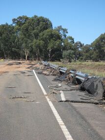
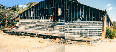
Photograph - Colour, Asphalt on Bridge, Floods, Carisbrook
... ...road damage...Ballarat Heritage Services PO Box 2209 Bakery Hill Post Office goldfields Carisbrook flood road damage asphalt Asphalt on Bridge, Floods, Carisbrook Photograph - Colour ...carisbrook, flood, road damage, asphalt -
 Eltham District Historical Society Inc
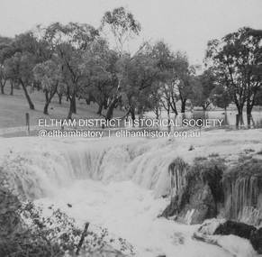
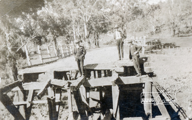
Album - Photograph Album, J.A. McDonald, Bridge and Road Reconstruction Works, Shire of Eltham, 1952-1962
... Road...Flood damage...Wood Fitzsimons Lane Bridge Flat Rock Road Flood damage floods Floodwater Footpaths and gutters Ford Service Garage G. ...J.A. McDonald produced this record in the course of his responsibilities as Shire Engineer for Eltham Shire Council.Record of various Shire of Eltham infrastructure works undertaken during the period of 1952-1962 involving bridge and road reconstruction projects, sometimes with Eltham Shire Council Project Reference numbers quoted. It was during this period that a number of significant improvements were made to roads and new bridges constructed within the shire that remain in place as of present day (2022). In many situations, the photos provide a tangible visible record of infrastructure that existed throughout the early days of the Shire. The album was put together by or under the direction of the Shire Engineer, J.A. McDonald.a. gillies, alistair knox park, benchmark studies, bend of islands, blease road, box hill state school, box hill teachers college, box hill tip, bridge construction, bridge street bridge, bridge, brisbane street, brougham steet, bulldozer, cecil street, charis pelling, cherry tree road, city of preston, cr. a. brinkkotter, cr. charis pelling, cranes, cromwell street, diamond creek (creek), diamond street, dixons creek bridge, dixon's creek road, drott, eltham leisure centre, eltham north, eltham police station, eltham, eltham-yarra glen road, f. wood, fitzsimons lane bridge, flat rock road, flood damage, floods, floodwater, footpaths and gutters, ford service garage, g. blair, garden hill, glen park bridge, glenauburn road, grand hotel, haldane road, healesville, healesville-yarra glen road, heidelberg-kinglake road, henley road bridge, henley road, hill property, hurstbridge water scheme, hurstbridge, hurstbridge-arthurs creek road, infrastructure, j. jolly, kangaroo ground, kangaroo ground-queenstown road, kangaroo ground-st andrews road, lilydale shire office, long gully bridge, long gully creek, long gully road, long gully, lower plenty bridge, lower plenty footbridge, lower plenty oval, lower plenty road, lower plenty, main road, methodist church, montmorency, mount pleasant road, new holland, old healesville road, opening ceremony, oxley bridge, para road, paul creek bridge, paul creek road, paul krafeznk, pinnacle lane, plaques, plenty river trail, plenty river, presbyterian church, prof donald thomson, pryor street, railway crossing, railway parade, rattray road, reconstruction works, reichelt avenue, research (vic.), research oval, road construction, rymers corner, shire of eltham, shire of whittlesea, silvan road bridge, silver street bridge, silver street, sir dallas brooks, smedley property, st andrews, steels creek, susan street, tarrawarra, tony carberry, uniting church, upper yarra dam, upper yarra reservoir, w.e. wolf, waterfall property, watsons creek, wattletree road bridge, wattletree road, wattletree road bridge, worlingworth, yarra glen, york street, yow yow creek -
 Eltham District Historical Society Inc
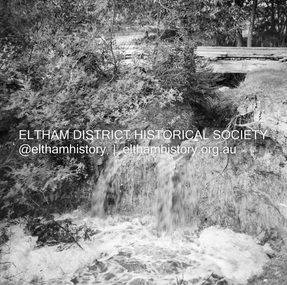
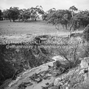
Album - Photograph, J.A. McDonald, Dixons Creek Road, 23 Sep. 1955
... Road...Flood damage...McDonald. 1955-09-23 bridge construction Dixons Creek Bridge Dixon's Creek Road Flood damage floods Infrastructure Road construction shire of eltham Black and white photo print (location of negative unknown) Adhered to a page in an album of 78 foolscap pages containing a sequence of photos, adhered via glue or sticky tape, with typed or handwritten headings and captions in pencil. ...Dixons Creek in floodRecord of various Shire of Eltham infrastructure works undertaken during the period of 1952-1962 involving bridge and road reconstruction projects, sometimes with Eltham Shire Council Project Reference numbers quoted. It was during this period that a number of significant improvements were made to roads and new bridges constructed within the shire that remain in place as of present day (2022). In many situations, the photos provide a tangible visible record of infrastructure that existed throughout the early days of the Shire. The album was put together by or under the direction of the Shire Engineer, J.A. McDonald.1955-09-23, bridge construction, dixons creek bridge, dixon's creek road, flood damage, floods, infrastructure, road construction, shire of eltham -
 Eltham District Historical Society Inc
Album - Photograph, J.A. McDonald, Dixons Creek Road, 23 Sep. 1955
... Road...Flood damage...McDonald. 1955-09-23 bridge construction Dixons Creek Bridge Dixon's Creek Road Flood damage floods Infrastructure Road construction shire of eltham Black and white photo print (location of negative unknown) Adhered to a page in an album of 78 foolscap pages containing a sequence of photos, adhered via glue or sticky tape, with typed or handwritten headings and captions in pencil. ...Dixons Creek in flood Temporary bridge washed outRecord of various Shire of Eltham infrastructure works undertaken during the period of 1952-1962 involving bridge and road reconstruction projects, sometimes with Eltham Shire Council Project Reference numbers quoted. It was during this period that a number of significant improvements were made to roads and new bridges constructed within the shire that remain in place as of present day (2022). In many situations, the photos provide a tangible visible record of infrastructure that existed throughout the early days of the Shire. The album was put together by or under the direction of the Shire Engineer, J.A. McDonald.1955-09-23, bridge construction, dixons creek bridge, dixon's creek road, flood damage, floods, infrastructure, road construction, shire of eltham -
 Eltham District Historical Society Inc
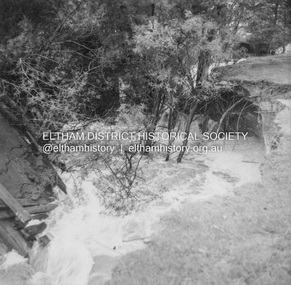
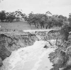
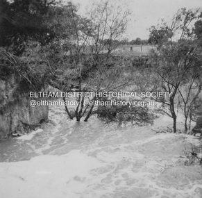
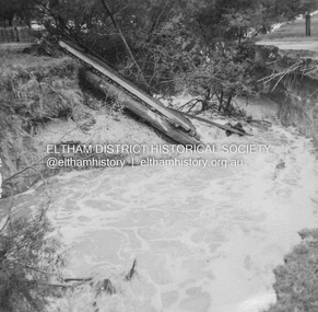
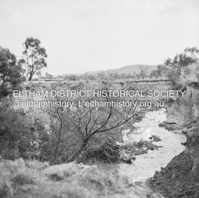
Negative - Photograph, J.A. McDonald, Dixons Creek, Sep. 1955
... Road...Flood damage...McDonald. 1955-09 Dixons Creek Bridge Dixon's Creek Road Flood damage floods Floodwater Infrastructure shire of eltham Medium format 120/Kodak 620 6x6 cm black and white negative (1 of 12) contained with Kodak processing envelope with various inscriptions and markings Originally inserted loose with other processing envelopes of negatives and prints within a binder of 78 foolscap pages containing a sequence of photos, adhered via glue or sticky tape, with typed or handwritten headings and captions in pencil, contained in a green foolscap binder with spring clasp spine for retaining loose pages. ...Record of various Shire of Eltham infrastructure works undertaken during the period of 1952-1962 involving bridge and road reconstruction projects, sometimes with Eltham Shire Council Project Reference numbers quoted. It was during this period that a number of significant improvements were made to roads and new bridges constructed within the shire that remain in place as of present day (2022). In many situations, the photos provide a tangible visible record of infrastructure that existed throughout the early days of the Shire. The album was put together by or under the direction of the Shire Engineer, J.A. McDonald.1955-09, dixons creek bridge, dixon's creek road, flood damage, floods, floodwater, infrastructure, shire of eltham -
 Eltham District Historical Society Inc
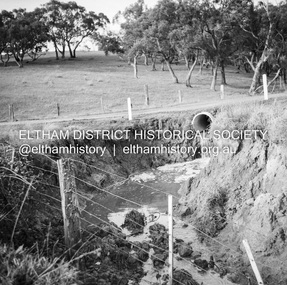
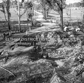
Negative - Photograph, J.A. McDonald, One Tree Hill Road Bridge, Christmas Hills, 2 July 1962
... Road...Property damage...McDonald. 1962-07-02 bridge construction Christmas Hills Infrastructure shire of eltham Victorian Bushfires - 1962 bush fires One Tree Hill Road Property damage Medium format 120/Kodak 620 6x6 cm black and white negative (1 of 12) contained in a Filmpro processing envelope with various inscriptions and markings. ...One Tree Hill Road Looking south 2/7/62 The bridge was destroyed by bushfires 15-16 January 1962. A temporary bridge was set up to the east sideRecord of various Shire of Eltham infrastructure works undertaken during the period of 1952-1962 involving bridge and road reconstruction projects, sometimes with Eltham Shire Council Project Reference numbers quoted. It was during this period that a number of significant improvements were made to roads and new bridges constructed within the shire that remain in place as of present day (2022). In many situations, the photos provide a tangible visible record of infrastructure that existed throughout the early days of the Shire. The album was put together by or under the direction of the Shire Engineer, J.A. McDonald.1962-07-02, bridge construction, christmas hills, infrastructure, shire of eltham, victorian bushfires - 1962, bush fires, one tree hill road, property damage -
 Eltham District Historical Society Inc
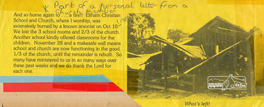
Photograph, Eltham Christian School, severely damaged by a deliberate fire, 10 October 1989, 1989
... road...fire damage...See also entries for each photograph. eltham christian school nyora road fire damage Typed letter printed on yellow paper with a black and white photograph Eltham Christian School, severely damaged by a deliberate fire, 10 October 1989 Photograph ...Part of a personal letter from a church member printed on yellow paper with a black and white photograph. Transcription: "And so home again to .. a fire!! Eltham Christina School and Church, where I worship was extensively burned by a known arsonist on Oct 10 (1998). We lost tthe 3 school rooms and 2/3 of the church. Another school kindly offered classrooms for the children. November 28 and a makesafe wall means school and church are now functioning in the good 1/3 of the church, until the remainder is rebuilt. So many have ministered to us in so many ways over these past weeks and we do thank the Lord for each one." The Stokes family settled in this area of Eltham in the 1940s and were associated with the Eltham Christian Church. In the 1970s this church had met in temporary premises in Eltham. Lots of the original 1920s subdivision remained south of Nyora Road and a number of these lots were utilized for the Eltham Christian School, which was established by the Eltham Christian Church in 1981. The school operated on this site until 2000. The premises were owned by the Nillumbik Community Church who were in operation till November 2010 when the Eltham Baptist Church commenced a lease arrangement until the site was purchased by them in April 2012. The building is constructed of brick and timber with a balcony on two sides that looks over an expanse of grass. Sources: STOKES ORCHARD – AN INCOMPLETE HISTORY February 28, 2015 http://www.elthamhistory.org.au/ Australian Christian Church Histories - Eltham Baptist Church http://www.churchhistories.net.au/church-catalog/eltham-vic-baptist/ From a magnetic spiral bound photo album featuring a series of photographs (some cropped) with captions relating to the staff, students and activities of the Eltham Christian School which operated as part of the Eltham Christian Church at Nyora Road, Eltham. See also entries for each photograph.Typed letter printed on yellow paper with a black and white photographeltham christian school, nyora road, fire damage -
 Eltham District Historical Society Inc
Photograph, Damage to the Eltham Christian School after a fire, 10 October 1989, Oct.1989
... road...fire damage...damaged until the remainder was rebuilt. The Stokes family settled in this area of Eltham in the 1940s and were associated with the Eltham Christian Church. In the 1970s this church had met in temporary premises in Eltham. Lots of the original 1920s subdivision remained south of Nyora Road...See also entries for each photograph. eltham christian school nyora road fire damage colour photograph Damage to the Eltham Christian School after a fire, 10 October 1989 Photograph ...Damage to the Eltham Christian School after a fire, 10 October 1989 On October 10, 1989, this building was extensively damaged by a known arsonist. The three school rooms and two thirds of the church were destroyed by fire. Another local school kindly offered the use of their classrooms for the children in the interim until repairs could be made. Six weeks later, on 28 November, a makesafe wall had been constructed allowing the school and church to continue functioning in the remaining one third of the church that had not been damaged until the remainder was rebuilt. The Stokes family settled in this area of Eltham in the 1940s and were associated with the Eltham Christian Church. In the 1970s this church had met in temporary premises in Eltham. Lots of the original 1920s subdivision remained south of Nyora Road and a number of these lots were utilized for the Eltham Christian School, which was established by the Eltham Christian Church in 1981. The school operated on this site until 2000. The premises were owned by the Nillumbik Community Church who were in operation till November 2010 when the Eltham Baptist Church commenced a lease arrangement until the site was purchased by them in April 2012. The building is constructed of brick and timber with a balcony on two sides that looks over an expanse of grass. Sources: STOKES ORCHARD – AN INCOMPLETE HISTORY February 28, 2015 http://www.elthamhistory.org.au/ Australian Christian Church Histories - Eltham Baptist Church http://www.churchhistories.net.au/church-catalog/eltham-vic-baptist/ From a magnetic spiral bound photo album featuring a series of photographs (some cropped) with captions relating to the staff, students and activities of the Eltham Christian School which operated as part of the Eltham Christian Church at Nyora Road, Eltham. See also entries for each photograph.colour photographeltham christian school, nyora road, fire damage -
 Charlton Golden Grains Museum Inc
Photograph, Cameron, Ian, 01/02/1973
... Highest flood since 1956, 25 feet 1 1/2 at the bridge, 4 inches of rain fell in the catchment. Road damage after the flood was estimated to be $74,800....Highest flood since 1956, 25 feet 1 1/2 at the bridge, 4 inches of rain fell in the catchment. Road damage after the flood was estimated to be $74,800. ...Taken by the editor of The Charlton Tribune Ian Cameron. Of the 1973 flood at Gordon Park and Croquet Club. Highest flood since 1956, 25 feet 1 1/2 at the bridge, 4 inches of rain fell in the catchment. Road damage after the flood was estimated to be $74,800.Large sepia photograph unframed, creased in top RH corner, surface torn on left edge. Unmountedgordon park, croquet club, charlton, floods -
 Federation University Historical Collection
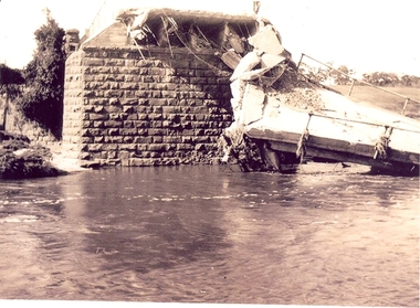
Photograph - Photographs, Richard Vincent, Washed Away Bridge at Garibaldi, c1933
... Newspaper clipping documents deputations to the Minister of Public Works for grants to be made available for repairs to bridges and roads damaged by heavy flooding in 1933, in particular, the replacement of a stone and concrete bridge over the Leigh River at Garibaldi in the Buninyong Shire. ...Three black and white photographs showing flood damage to the bridge over the Leigh River at Garibaldi, plus a photocopy of a newspaper clipping from The Argus December 1933 describing the extent of the flood damage. .1) shows blue stone buttress and collapsed bridge/road. .2) mirror image of above .3) unknown man waling an a girder of the Garibaldi bridge .4) photocopy of newspaper clipping about flood damage from The Argus December 1933...Barker Library (top floor) Mount Helen goldfields Newspaper clipping documents deputations to the Minister of Public Works for grants to be made available for repairs to bridges and roads damaged by heavy flooding in 1933, in particular, the replacement of a stone and concrete bridge over the Leigh River at Garibaldi in the Buninyong Shire. ...Newspaper clipping documents deputations to the Minister of Public Works for grants to be made available for repairs to bridges and roads damaged by heavy flooding in 1933, in particular, the replacement of a stone and concrete bridge over the Leigh River at Garibaldi in the Buninyong Shire. The concrete slabs were still in the water in the 1960s/70s or even later. Three black and white photographs showing flood damage to the bridge over the Leigh River at Garibaldi, plus a photocopy of a newspaper clipping from The Argus December 1933 describing the extent of the flood damage. .1) shows blue stone buttress and collapsed bridge/road. .2) mirror image of above .3) unknown man waling an a girder of the Garibaldi bridge .4) photocopy of newspaper clipping about flood damage from The Argus December 1933Damage by Floods: Bridges washed away (The Argus December 1933)leigh river, garibaldi, buninyong shire, richard vincent, garibaldi bridge -
 Orbost & District Historical Society
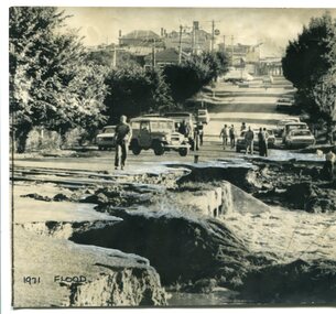
Photograph - 1971 flood, Orbost, The Herald, 8.2.1971
... This photo shows road damage at the southern end of Nicholson Street, adjacent to the Snowy River. ...A b/w photo showing severe damage to a roadway in the foreground, people walking on the intact roadway behind, and the road leading up a hill through buildings. ...This photo shows road damage at the southern end of Nicholson Street, adjacent to the Snowy River. ...This is one of many photos taken following the devastating Snowy River flood of 1971 which inflicted huge impact on the Orbost area, including access roads to Orbost. This photo shows road damage at the southern end of Nicholson Street, adjacent to the Snowy River. This was the main road leading in to Orbost and also the Princes Highway in 1971. Orbost was completely cut off for several days following this flood. This photo is significant because it shows the impact of the 1971 Snowy River flood on the main road leading into Orbost. A b/w photo showing severe damage to a roadway in the foreground, people walking on the intact roadway behind, and the road leading up a hill through buildings. Written in black ink below the photo: '1971 flood'. Written on the back of the photo: 'Orbost and its 3,000 people in East Gippsland were cut off today by 50 square miles of Snowy River floodway. The washed out Princes Highway a quarter mile on the Melbourne side of Orbost in East Gippsland, today. ln the background is Orbost's main street'.orbost, snowy river, 1971 flood damage -
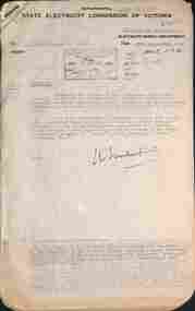 Ballarat Tramway Museum
Document - letter re, State Electricity Commission of Victoria (SECV), "Tramways Abandonment" and "Geelong Tramways - Review", 1953
... Set of letters and memos regarding road damage by buses in West Geelong and a report and notes regarding Geelong Tramways. ...Ballarat Tramway Museum South Gardens Reserve Wendouree Parade Ballarat Ballarat goldfields Set of letters and memos regarding road damage by buses in West Geelong and a report and notes regarding Geelong Tramways. ...Set of letters and memos regarding road damage by buses in West Geelong and a report and notes regarding Geelong Tramways. Includes Early history of Geelong, Creation of the SEC, acquisition by the SEC, agreements with Councils, proposed extensions, physical characteristics of Geelong, the Outlook for Geelong, attempts to define transport future, review of operations, with reference to financial statement, tramcars, fare schedules, employees, trams used, services supplied, passenger density, outlook, costs, possible improvements, and conclusions. Includes tables for income and expenses from 1935 to 1953, and statistics for operations.Demonstrates an extensive appraisal of the Geelong tram system in 1953.Document - 20 foolscap sheets with rounded corners and 1 quarto sheet - typed. held by a brass folding clip in the top left hand corner.tramways, tramcars, operations, secv, geelong, history -
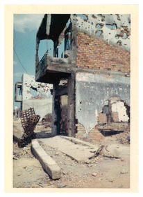 National Vietnam Veterans Museum (NVVM)
Photograph - Tet damage
... A coloured photograph showing a damaged building in the foreground with holes and debris in the front. Further down the road is another damaged building with debris filling the roadway....Medical Marshall Rosalind Radiographer Vietnam A coloured photograph showing a damaged building in the foreground with holes and debris in the front. Further down the road is another damaged building with debris filling the roadway. ...Photograph taken by Rosalind Marshall whilst a volunteer radiographer working in Bien Hoa South Vietnam as a civilian in a medical facility. This item contributes to an understanding of those involved in the war in Vietnam other than Australian servicemen.A coloured photograph showing a damaged building in the foreground with holes and debris in the front. Further down the road is another damaged building with debris filling the roadway.medical, marshall rosalind, radiographer, vietnam -
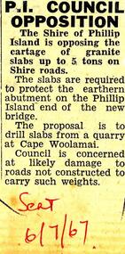 Phillip Island and District Historical Society Inc.
Newspaper clippings, 06/07/1967
... re opposition granite cartage; damage to roads; slabs are required to protect earthen abutment on P.I. end of new bridge....Dated 1960 - 1973 local history newspapers granite cartage phillip island cape woolamai granite jean jamieson re opposition granite cartage; damage to roads; slabs are required to protect earthen abutment on P.I. end of new bridge. ...Collected in Scrap book mostly, it is thought, from local newspapers - Wonthaggi 'Sentinel Times'. Dated 1960 - 1973re opposition granite cartage; damage to roads; slabs are required to protect earthen abutment on P.I. end of new bridge.local history, newspapers, granite cartage phillip island, cape woolamai granite, jean jamieson -
 Eltham District Historical Society Inc
Photograph, Main Road Bridge, Eltham, c.1924
... The wooden Main Road Bridge was substantially damaged in the 1924 flood and was replaced with a concrete structure Pages from a scrapbook belonging to Heather Jenkins (nee Cone) who lived as a child in the Police Residence at 728 Main Road, Eltham in the 1920s....Eltham District Historical Society Inc 728 Main Rd Eltham melbourne The wooden Main Road Bridge was substantially damaged in the 1924 flood and was replaced with a concrete structure Pages from a scrapbook belonging to Heather Jenkins (nee Cone) who lived as a child in the Police Residence at 728 Main Road, Eltham in the 1920s. ...The wooden Main Road Bridge was substantially damaged in the 1924 flood and was replaced with a concrete structure Pages from a scrapbook belonging to Heather Jenkins (nee Cone) who lived as a child in the Police Residence at 728 Main Road, Eltham in the 1920s.This photo shows the flood damage to the bridge structure or the dismantling of the bridge post 1924 flood. Heather Jenkins was the daughter of Constable John Thomas Cone, Badge #3935 served at Eltham Police Station 1 May 1911 to 9 July 1922.Glued on a brown paper scrapbook page (torn from scrapbook) with 9 black and white/sepia photos of varying sizes, 1 newspaper clipping and handwritten captions in ink.On verso in pencil "Const. W.C. Sargeant 1922-1927 - see Police list"eltham, main road, main road bridge -
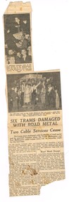 Melbourne Tram Museum
Newspaper, The Argus, "Six Trams Damaged with Road Metal", 15/03/1937 12:00:00 AM
... Newspaper Clipping - from The Argus Monday 15/3/1937, titled "Six Trams Damaged with Road Metal", about the damage caused at the time of the closure of the South Melbourne and Port Melbourne cable tram services - by souvenir hunters and people at the Port Melbourne depot who through road metal (stones) at the trams as they came into the depot. ...Melbourne Tram Museum 8 Wallen Road Hawthorn melbourne Trams tramways Collins St Port Melbourne South Melbourne Cable Trams Closure Buses Newspaper Clipping - from The Argus Monday 15/3/1937, titled "Six Trams Damaged with Road Metal", about the damage caused at the time of the closure of the South Melbourne and Port Melbourne cable tram services - by souvenir hunters and people at the Port Melbourne depot who through road metal (stones) at the trams as they came into the depot. ...Newspaper Clipping - from The Argus Monday 15/3/1937, titled "Six Trams Damaged with Road Metal", about the damage caused at the time of the closure of the South Melbourne and Port Melbourne cable tram services - by souvenir hunters and people at the Port Melbourne depot who through road metal (stones) at the trams as they came into the depot. The timeline gives the date of closure as Saturday 13/3/1937. Notes one of the Gripmen was a Mr. J. Armstrong. A comparison with the cutting as collected and the reproduction in The Argus on Trove, while the same photographs has a different text layout and text, possibly indicating two different editions of the paper.trams, tramways, collins st, port melbourne, south melbourne, cable trams, closure, buses -
 Canterbury History Group
Photograph - Demolition of Theatre in Maling Road, 1992
... The Maling Road theatre was badly damaged by fire in 1990 and demolished in 1993. ...Canterbury History Group 190A Canterbury Road Canterbury melbourne The Maling Road theatre was badly damaged by fire in 1990 and demolished in 1993. ...The Maling Road theatre was badly damaged by fire in 1990 and demolished in 1993. Built as a Hoyts Theatre in 1942 it later became the New Canterbury Ballroom and in 1971 the Immanuel Revival Centre. Part of a set of 8 coloured photographs taken by Jan Pigot to record the demolition of some shops and the old theatre to make way for new shops in Maling Road.Colour photocanterbury, maling road, maling theatre, new canterbury ballroom, immanuel revival centre -
 Ballarat Tramway Museum
Slide - 35mm slide/s - set of 5, John Theodore, 1973
... Set of 5 AGFA blue and white plastic mounts 27mm sq slides of work at the depot, following the completion of 1 road, c1974. .1 - 1 road looking towards the depot fan with 26 and 27 in the view. .2 - tram 28 out on 2 road with the damaged end showing. .3 - Checking 1 road with the trolley. ...Set of 5 AGFA blue and white plastic mounts 27mm sq slides of work at the depot, following the completion of 1 road, c1974. .1 - 1 road looking towards the depot fan with 26 and 27 in the view. .2 - tram 28 out on 2 road with the damaged end showing. .3 - Checking 1 road with the trolley. ...Yields information about depot activities of the BTPS in building the depot fan and access track.Set of 5 AGFA blue and white plastic mounts 27mm sq slides of work at the depot, following the completion of 1 road, c1974. .1 - 1 road looking towards the depot fan with 26 and 27 in the view. .2 - tram 28 out on 2 road with the damaged end showing. .3 - Checking 1 road with the trolley. Andrew Cook, Peter Rees and Graeme Jordan .4 - 28, 27 and 26 on the depot fan .5 - sawing rails on 1 road to join up with the depot tracks.Various notations by John as to the slide number and the trams in pencil and ink.tramways, trams, btps, depot, track construction, trams, tram 27, tram 26, tram 28 -
 Orbost & District Historical Society
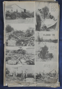
newspaper clippings, June 1978
... Extensive flooding in Eastern Victoria during June 1978, caused widespread damage to roads, road closures and hazards to traffic, particularly over the Queen's Birthday holiday weekend. ...Extensive flooding in Eastern Victoria during June 1978, caused widespread damage to roads, road closures and hazards to traffic, particularly over the Queen's Birthday holiday weekend. ...Orbost has been subject to major floods throughout its history, such as those which left the town isolated in 1934, 1952, 1971 and 1978. It is recorded that the Snowy River broke its banks and flooded the flats 104 times between 1884 and 1978. Extensive flooding in Eastern Victoria during June 1978, caused widespread damage to roads, road closures and hazards to traffic, particularly over the Queen's Birthday holiday weekend. These newspaper articles are contemporary records of a significant event in Orbost history.A collection of black/white newspaper clippings relating to the 1978 flood in Orbost. Some are original articles. others are photo-copies. They appear to be from the Snowy River Mail newspaper.floods-orbost-1978 newspaper-articles -
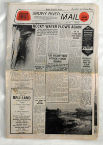 Orbost & District Historical Society
newspaper, Snowy River Mail, June 14 1978
... Extensive flooding in Eastern Victoria during June 1978, caused widespread damage to roads, road closures and hazards to traffic, particularly over the Queen's Birthday holiday weekend....Extensive flooding in Eastern Victoria during June 1978, caused widespread damage to roads, road closures and hazards to traffic, particularly over the Queen's Birthday holiday weekend. ...Orbost has been subject to major floods throughout its history, such as those which left the town isolated in 1934, 1952, 1971 and 1978. It is recorded that the Snowy River broke its banks and flooded the flats 104 times between 1884 and 1978. Extensive flooding in Eastern Victoria during June 1978, caused widespread damage to roads, road closures and hazards to traffic, particularly over the Queen's Birthday holiday weekend.Since 1890 the Snowy River Mail has been the local newspaper of the Orbost district.This local paper has been the means by which readers in Orbost were able to learn about newsworthy events and issues in their local community for over a century. This paper is a contemporary record of a significant event in Orbost's history of flooding.A newspaper, Snowy River Mail, which contains black / white photographs of the 1978 floods in Orbost.orbost-floods-1978 -
 Orbost & District Historical Society
black and white photograph, January 1934
... Extensive flooding in Eastern Victoria during June 1978, caused widespread damage to roads, road closures and hazards to traffic, particularly over the Queen's Birthday holiday weekend....Extensive flooding in Eastern Victoria during June 1978, caused widespread damage to roads, road closures and hazards to traffic, particularly over the Queen's Birthday holiday weekend. ...Orbost has been subject to major floods throughout its history, such as those which left the town isolated in 1934, 1952, 1971 and 1978. It is recorded that the Snowy River broke its banks and flooded the flats 104 times between 1884 and 1978. Extensive flooding in Eastern Victoria during June 1978, caused widespread damage to roads, road closures and hazards to traffic, particularly over the Queen's Birthday holiday weekend.This is a pictorial record of a significant event in Orbost's history.A very faded black / white photograph of flood water under the railway viaduct at watt's Gulch.orbost-flood-1934 railway-viaduct-orbost -
 Sunshine and District Historical Society Incorporated
Administrative record - City of Sunshine - Commissioner Mr Alexander Alex George Gillon Collection 1976 - 1982 - Report of committee meetings 25th November 1980, City of Sunshine, 25th November 1980
... Sassella Park ICI Oval Deer Park Primary School cleanup Traffic Lights Main Road West and Station Road intersection Damage to property by golf balls 5 Boa Court Sunshine West Proposed purchase of former part of discontinued road Bridge of Kororoit Creek at Billingham Road Shops at Hampshire Road footpath Rear access to Service Station corner Ballarat Road and Alford Street Selwyn Park Deer Park Cricket Club Kinder Smith Reserve Road Works Rowe Street Community Hall Housing Commission Coleman Street, Greenham Street and Gilder Street Maidstone School Hall St. ...Albans Sunshine United Cricket Club Sunshine Park Tennis Club Parsons Reserve Stanford Street Sunshine Errington Reserve Main Road East Sassella Park ICI Oval Deer Park Primary School cleanup Traffic Lights Main Road West and Station Road intersection Damage to property by golf balls 5 Boa Court Sunshine West Proposed purchase of former part of discontinued road Bridge of Kororoit Creek at Billingham Road Shops at Hampshire Road footpath Rear access to Service Station corner Ballarat Road and Alford Street Selwyn Park Deer Park Cricket Club Kinder Smith Reserve Road Works Rowe Street Community Hall Housing Commission Coleman Street, Greenham Street and Gilder Street Maidstone School Hall St. ...Sassella Park ICI Oval Deer Park Primary School cleanup Traffic Lights Main Road West and Station Road intersection Damage to property by golf balls 5 Boa Court Sunshine West Proposed purchase of former part of discontinued road Bridge of Kororoit Creek at Billingham Road Shops at Hampshire Road footpath Rear access to Service Station corner Ballarat Road and Alford Street Selwyn Park Deer Park Cricket Club Kinder Smith Reserve Road Works Rowe Street Community Hall Housing Commission Coleman Street, Greenham Street and Gilder Street Maidstone School Hall St. Albans Heights Primary School Playground Equipment Tallintyre Reserve Sunshine United Cricket Club Selwyn Park Sunshine Park Tennis Club Errington Reserve sassella park, station road, main road west, deer park primary school, ballarat road, deer park, boa court, sunshine west, kororoit creek, billingham road, alford street, sunshine north, selwyn park, selwyn street, albion, deer park cricket club, kinder smith reserve, braybrook, tallintyre reserve, kermeen street, st. albans heights primary school, norwich street, st. albans, sunshine united cricket club, sunshine park tennis club, parsons reserve, stanford street, sunshine, errington reserve, main road east -
 Warrnambool and District Historical Society Inc.
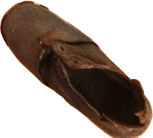
Footwear - Child's boot, 1940s
... At least five lives were lost, many small settlements and towns were isolated resulting in food shortages, onion and potato crops were ruined, 20 bridges were destroyed or damaged, roads were swept away, hundreds of farm animals perished and road and rail services were disrupted. ...road This small shoe (or boot) was found at Rosebrook, a small settlement between Warrnambool and Port Fairy, after the 1946 Western District floods. These floods are regarded as the worst in the history of European settlement in the Western District. At least five lives were lost, many small settlements and towns were isolated resulting in food shortages, onion and potato crops were ruined, 20 bridges were destroyed or damaged, roads were swept away, hundreds of farm animals perished and road and rail services were disrupted. ...This small shoe (or boot) was found at Rosebrook, a small settlement between Warrnambool and Port Fairy, after the 1946 Western District floods. These floods are regarded as the worst in the history of European settlement in the Western District. At least five lives were lost, many small settlements and towns were isolated resulting in food shortages, onion and potato crops were ruined, 20 bridges were destroyed or damaged, roads were swept away, hundreds of farm animals perished and road and rail services were disrupted. The floods were the result of a very high rainfall in five successive days (658 points of rain in one 24 hours) and there was more flooding a week after the first major impact of the rains. A link to a major weather event in the South west.This is a small child’s brown shoe made of leather with a lace-up upper part (no laces) and a leather sole. The sides of the upper part of the shoe have broken away at the edges. As the shoe has been water-logged (it was found after the 1946 Western District floods) it has become hard and brittle. warrnambool, rosebrook western district floods, 1946, 1940's shoe -
 Bendigo Historical Society Inc.
Document - MCCOLL, RANKIN AND STANISTREET COLLECTION: EAST CLARENCE GOLD MINING CO NL, 1932 - 1946
... Russell of 7 Willowbank Road N7, Melbourne. War Damage Commission receipts. Correspondence from The English Scottish & Australian Bank Limited regarding Treasury Bonds. ...Russell of 7 Willowbank Road N7, Melbourne. War Damage Commission receipts. Correspondence from The English Scottish & Australian Bank Limited regarding Treasury Bonds. ...Document. Envelope contains: - Insurance Policies, Receipts Hire agreement for Steam driven air compressor and site map and specifications. Tender for new compressor, treasure Bonds and Lease Agreements. Envelope with a 2 pence red postage stamp with the profile of King George 5th and a crown above his head addressed to Mrs. C. Russell of 7 Willowbank Road N7, Melbourne. War Damage Commission receipts. Correspondence from The English Scottish & Australian Bank Limited regarding Treasury Bonds. Receipt for Boiler Test, Certificate of inspection of Boiler.McColl, Rankin & Stanistreetorganization, business, gold mining - legal, mccoll, rankin & stanistreet, east clarence gmc nl, gold mining, insurance policies, treasury bonds